
GEOM-410 · Lesson 9 of 12 · 20 min
Indigenous lands and Canada Lands surveys
West and south of Lethbridge lies the Blood reserve, the home reserve of the Kainai Nation, one of the four nations of the Blackfoot Confederacy. At about 1,414 km² it is the largest reserve by area in Canada, filling most of the land between Lethbridge, Fort Macleod and Cardston, with the St. Mary and Belly rivers running through and along it. Several of the district's canals and the river reaches it draws from lie close to its boundaries, and the district works with the Nation on water, roads and drainage. Reserve land is not provincial land. It is part of Canada Lands, surveyed under federal law by Canada Lands Surveyors, recorded in federal registries, and governed by the Indian Act, treaties, modern agreements and the Nation's own laws. This lesson explains that system and how a provincial surveyor should work alongside it.
What Canada Lands are
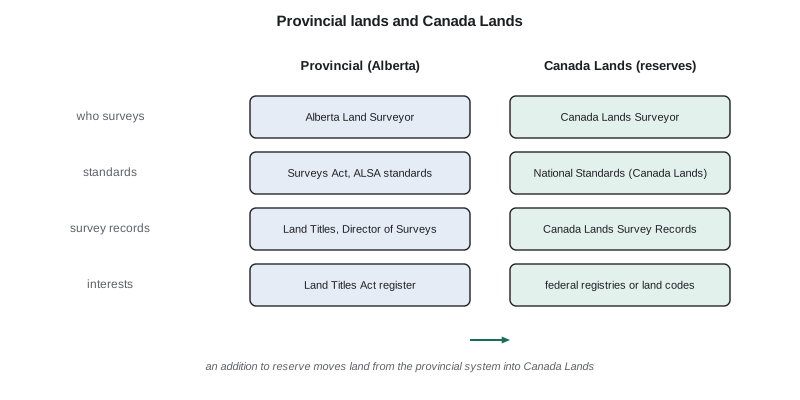
Canada Lands include all lands in Yukon, the Northwest Territories and Nunavut, more than 3,100 Indian reserves, national parks and national historic sites, and Canada's offshore areas. Their boundaries are defined under the Canada Lands Survey System, which is managed by the Surveyor General Branch of Natural Resources Canada under the Canada Lands Surveys Act. The Surveyor General defines, marks and describes the boundaries of Canada Lands, sets the National Standards for the Survey of Canada Lands, and checks the quality of surveys before they are accepted into the Canada Lands Survey Records, the federal archive of plans, field notes and reports. Natural Resources Canada does not manage provincial or municipal surveys or property rights; those stay with the provinces.
Field surveys on Canada Lands are carried out by Canada Lands Surveyors, who are licensed by the Association of Canada Lands Surveyors under the Canada Lands Surveyors Act. Private surveying companies do almost all of this work, including more than 99 % of the surveying for modern treaty land claims. Many Canada Lands Surveyors also hold a provincial commission, so the same person may survey a farm quarter under Alberta law in the morning and a reserve boundary under federal law in the afternoon, using different standards, plan requirements and record systems for each.
Reserve boundaries and their history
Most reserves on the prairies were set apart under the numbered treaties of the 1870s and surveyed in the decades that followed. The Blackfoot nations, including the Kainai, entered Treaty 7 in 1877, and their reserves were surveyed in the early 1880s. Reserve boundaries were often surveyed by Dominion land surveyors working to instructions that differed from those for homestead townships, and their monuments, field notes and plans are held in the Canada Lands Survey Records. Many boundaries follow rivers, which brings the water boundary questions of Lesson 5 into federal law.
Reserve boundaries are not only survey questions. Many First Nations have shown, through specific claims and litigation, that the reserves surveyed for them were smaller than their treaty entitled them to, or that land was later taken from reserves without proper consent or compensation. In 2019, the Federal Court found that the Blood Tribe was entitled under Treaty 7 to a larger reserve than the one surveyed in the 1880s, leaving the remedy to be decided later. A surveyor who works near a reserve boundary must therefore treat it with the same care as any boundary, and also with an understanding that its history may still be the subject of claims, negotiations and court cases between the Nation and Canada. It is not the surveyor's role to comment on those questions, but it is the surveyor's duty to get the evidence right.
Interests in reserve land
Reserve land is held by the Crown for the use and benefit of the First Nation, and interests in it are recorded in federal registries rather than at the provincial Land Titles Office. Under the Indian Act, individual members may hold lawful possession of reserve land, and leases, permits and other interests may be granted, with records kept in the Indian Lands Registry System. First Nations that have adopted their own land codes under the Framework Agreement on First Nation Land Management, and later the First Nations Land Management Act, manage their reserve lands under their own laws, and their interests are recorded in the First Nations Land Register. For such lands the Surveyor General Branch prepares legal descriptions of the lands covered by each land code, after research to identify and resolve issues such as conflicts between a reserve plan and its written description.
For the district, the practical points are clear. A canal, road or pipeline across reserve land needs an interest granted under federal law or the Nation's land code, surveyed by a Canada Lands Surveyor and recorded in the appropriate federal register. An Alberta right-of-way plan and a Land Titles registration do not apply. The district's surveyor may retrace the provincial side of a boundary, but cannot alter the reserve boundary and must not set monuments on reserve land without permission. Where the provincial and reserve surveys disagree about the position of a shared boundary, the question goes to the Surveyor General and the parties, not to the provincial surveyor alone.
The federal records are a resource for any surveyor near a reserve. Plans, field notes and reports in the Canada Lands Survey Records can be searched online through Natural Resources Canada's tools, and the original 1880s survey of a reserve boundary, with its monuments and its notes on rivers and trails, is often the best evidence of where the boundary and the adjoining township lines were run. Leah requests copies early, because the reserve survey and the township survey were sometimes made by different crews in different years, and the ties between them explain differences that would otherwise look like errors.
Additions to reserves and treaty land entitlement
Land also moves from the provincial system into Canada Lands. Under additions-to-reserve processes and treaty land entitlement settlements, which resolve historic shortfalls in reserve land, First Nations acquire land, often by purchase from willing sellers, and Canada sets it apart as reserve. Each addition needs a survey and a legal description that meet federal standards, and the Surveyor General Branch provides research, advice, survey management and legal descriptions for the transfer. Third-party interests on the land, such as a utility right of way or an irrigation district's canal, must be dealt with before or during the transfer, usually by converting them into permits or other interests under federal law.
Coulee Geomatics has worked on one such parcel: a quarter section beside a district lateral that a neighbouring First Nation bought for an addition to reserve. Ruth's role was limited and clear. She retraced the district's right of way across the quarter and prepared a plan of it under provincial law, so that the district, the Nation and Canada knew exactly what interest needed to be addressed. A Canada Lands Surveyor, working for the Nation under the Surveyor General's instructions, surveyed the parcel for the addition. The two surveyors shared their evidence and agreed the ties between their surveys before either plan was finished.
Métis Settlements
Alberta has a further land system that a surveyor in the province should know. The eight Métis Settlements in east-central and northern Alberta are held under letters patent by the Métis Settlements General Council, under provincial legislation, the Metis Settlements Land Protection Act and the Metis Settlements Act, which together protect the land base and set out how individual members hold interests in it. The Settlements are not Canada Lands; they are surveyed under provincial law, but the interests within them are governed by the Settlements' own rules and registry rather than by ordinary land titles. Like a reserve, a Settlement is a community's home and its governance must be respected; a surveyor working there begins by contacting the Settlement council and its land staff.
Reading the old field books
Both provincial and Canada Lands surveyors often work from field books of the 1880s, kept in chains and links. A chain is 66 feet, or 20.1168 m, divided into 100 links. Comparing the record with modern measurements shows how the old chain behaved and helps predict where unfound features, such as a creek crossing recorded in the notes, should be.
# Reading an 1880s field book: chains and links to m, and comparing record with measurement
CHAIN = 20.1168            # m; 100 links to the chain
def ch(chains, links=0):   # chains and links -> m
    return (chains + links / 100.0) * CHAIN

# Mile posts and line notes along an old boundary line (record, in chains and links)
record = [("post 1", 0, 0), ("post 2", 80, 0), ("creek, left bank", 112, 45), ("post 3", 160, 12), ("post 4", 240, 5)]
measured = {"post 2": 1609.88, "post 3": 3221.86, "post 4": 4829.95}   # m, from the 2026 GNSS survey

print("feature             record (m)   measured (m)   ratio")
for name, c, l in record:
    r = ch(c, l)
    m = measured.get(name)
    print(f"{name:18s} {r:10.2f}   " + (f"{m:10.2f}     {m / r:.5f}" if m else "      -"))
ratios = [measured[n] / ch(c, l) for n, c, l in record if n in measured]
k = sum(ratios) / len(ratios)
print(f"mean ratio {k:.5f}: the old chain ran about {(k-1)*1e4:+.1f} cm long per 100 m")
print(f"predicted creek bank from the record and the ratio: {ch(112, 45)*k:.2f} m from post 1")

# Area of a fractional lot recorded as 38.62 acres = ? ha
print(f"38.62 acres = {38.62*0.40468564224:.3f} ha; 10 square chains = 1 acre = {10*CHAIN**2:.2f} m2")feature record (m) measured (m) ratio post 1 0.00 - post 2 1609.34 1609.88 1.00033 creek, left bank 2262.13 - post 3 3221.10 3221.86 1.00024 post 4 4829.04 4829.95 1.00019 mean ratio 1.00025: the old chain ran about +2.5 cm long per 100 m predicted creek bank from the record and the ratio: 2262.71 m from post 1 38.62 acres = 15.629 ha; 10 square chains = 1 acre = 4046.86 m2
Along this boundary the old measurements run consistently short of the modern ones by about 2.5 parts in 10,000: the chain the 1880s crew used was a little long, so it recorded fewer chains than the true distance. The ratio is not a correction to apply to the boundary, which stays where its monuments are; it is a tool for finding things. Using it, the crew predicts the left bank of the creek recorded at 112 chains 45 links at about 2,262.7 m from post 1, and finds the old bank scarp within a metre of that position.
Worked problem
Chains and links to metres
A field book records a post at 39 chains 87 links from a corner. How far is that in metres and in feet?
Show solution
- \[39.87 \times 20.1168 = 802.06\ \text{m}\]
- \[39.87 \times 66 = 2631.4\ \text{ft}\]
Answer: About 802.06 m, or 2,631 ft.
Working respectfully
Survey work near or on reserve land is work in someone else's territory and under their governance. Good practice starts early: contact the Nation's lands department before field work, explain what the survey is for, ask about access and any cultural or environmental sites to avoid, and share results. Many Nations employ their own lands staff and surveyors, and some require their own permits for work on reserve. A surveyor who arrives unannounced at a reserve boundary with a crew and a metal detector damages trust that took years to build, however good the measurements are.
Common mistakes
MistakeRegistering a canal right of way over reserve land at the provincial Land Titles Office.
InsteadInterests in reserve land are granted under federal law or the Nation's land code and recorded in federal registers.
MistakeTreating a reserve boundary as if it were an ordinary farm boundary under provincial law.
InsteadIt is a Canada Lands boundary; changes and disputes go through the Surveyor General and the parties.
MistakeSetting monuments on reserve land without permission.
InsteadContact the Nation's lands department and follow its requirements.
MistakeUsing the chain ratio to move a boundary.
InsteadUse it to find evidence; monuments still control.
Summary and key terms
- Canada Lands include the territories, more than 3,100 reserves, national parks and offshore areas.
- The Surveyor General Branch manages the Canada Lands Survey System; Canada Lands Surveyors, licensed by the ACLS, do the field work.
- Reserve interests are recorded in federal registries, or under First Nations land codes, not at Land Titles.
- Reserve boundaries may be subject to claims; the surveyor's duty is to get the evidence right.
- Additions to reserves move land from the provincial system into Canada Lands; third-party interests must be addressed.
- Work near reserves starts with contact, permission and respect for the Nation's governance.
- Canada Lands
- Federal lands surveyed under the Canada Lands Survey System, including reserves.
- Surveyor General Branch
- The branch of Natural Resources Canada that manages surveys of Canada Lands.
- Canada Lands Surveyor
- A surveyor licensed by the ACLS to survey Canada Lands.
- Canada Lands Survey Records
- The federal archive of plans, notes and reports for Canada Lands.
- Addition to reserve
- The process by which land becomes part of a reserve.
- Land code
- A First Nation's own law for managing its reserve lands under the land management framework.
- Chain
- A unit of 66 feet (20.1168 m), divided into 100 links.
Practice problems
Work each problem on paper first, then reveal the answer to check.
Who licenses Canada Lands Surveyors?
Show answer
The Association of Canada Lands Surveyors.
Where are interests in reserve land recorded?
Show answer
In federal registries such as the Indian Lands Registry System or the First Nations Land Register.
Convert 80 chains 25 links to metres.
Show answer
80.25 × 20.1168 = 1614.37 m.
What happens to a district canal right of way when land is added to a reserve?
Show answer
It must be addressed in the transfer, often by converting it to an interest under federal law.
Name two steps of good practice before field work near a reserve.
Show answer
Contact the Nation's lands department, explain the work, ask about access and sites, and share results.
Lesson quiz · 5 questions
Score 60% or more to complete this lesson.
Create a free account to save your progress, take quizzes and earn a certificate.