
GEOM-410 · Lesson 1 of 12 · 22 min
Land tenure and the cadastre
For five courses Coulee Geomatics has measured the irrigation district's world: its control network, its canals, its reservoir and the fields it serves. This year the district asks a different kind of question. Its board wants to know, parcel by parcel, whether the district actually holds the land under its 600 km of canals and laterals, and on what terms. Some rights of way were registered by plan in the 1920s and 1950s; some were taken by agreement with farmers and never registered; a few cross land whose owners have changed a dozen times and whose fences no longer match any plan. Ruth Albrecht, the firm's principal and an Alberta Land Surveyor, takes the job. Ines Dahl will lead the field retracements, Leah Tran the research and plans, Theo Martel the computations and the database, and Grant Okonkwo the field crew. This course follows that project, from the first title search to the last plan signed.
Land tenure: who holds what
Land tenure is the set of rules by which a society decides who may use land, for what, for how long and under what conditions. In the common-law tradition that both Canada and the United States inherited from England, no private person owns land outright in the way one owns a book. A person owns an estate in land, which is a bundle of rights defined by law: the right to occupy and use it, to exclude others, to lease it, to mortgage it, to sell it and to leave it to heirs. The largest estate a private person can hold is the fee simple, which lasts indefinitely and passes freely by sale or will. Smaller estates include the life estate, which ends at the holder's death, and the leasehold, which lasts for a fixed term under a lease.
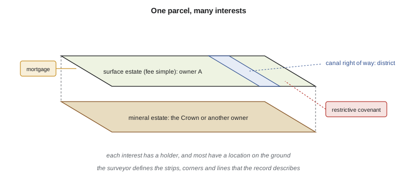
Beside estates sit lesser interests that other people hold in someone else's land. An easement gives a right to use land for a purpose, such as a road, a pipeline or a canal, without owning it. A mortgage gives a lender security over land. A restrictive covenant limits what an owner may build or do. A mineral interest may belong to someone other than the surface owner. A single parcel can therefore carry many interests at once, held by different people, and the land surveyor's work touches nearly all of them, because almost every interest has a location: a strip, a corner, a line or an area on the ground.
In Canada, all land was originally held by the Crown. Private titles began as grants from the Crown, called patents or grants, and land that has never been granted remains Crown land, which in Alberta is usually called public land. A large share of Alberta, especially in the north and along the Eastern Slopes of the Rockies, is still public land managed by the province, and the province also owns the beds and shores of most naturally occurring lakes and rivers. Federal Crown land includes national parks, military lands and Indian reserves, which follow their own survey and registration system. On the prairies, mineral rights were often kept by the Crown or by railway and land companies when the surface was granted, so it is common for a farmer in southern Alberta to hold the surface title while the Crown, or a freehold mineral owner, holds the rights to oil and gas beneath it.
What a cadastre is
A cadastre is an official, parcel-based record of land: where each parcel is, how big it is, and, in most systems, who holds what rights in it. The word comes through French from a Latin root for a register of taxable land, and the oldest cadastres were indeed tax rolls. The International Federation of Surveyors (FIG) describes a modern cadastre as a parcel-based, up-to-date land information system containing a record of interests in land, usually with a geometric description of each parcel linked to records of the rights, restrictions and responsibilities attached to it. Three roles are usually recognized. A fiscal cadastre supports property taxation by recording parcel areas and values. A juridical or legal cadastre supports the land market by recording rights and boundaries so that land can be bought, sold and mortgaged with confidence. A multipurpose cadastre adds other layers, such as land use, utilities and environmental constraints, so that the parcel fabric serves planning and administration.
Every cadastre has two halves that must agree. The textual half holds the rights: the registered owner, the mortgages, the easements, the caveats or liens. The spatial half holds the parcels: their boundaries, areas and identifiers. In older systems the spatial half was a set of survey plans, each drawn to its own local bearings; in modern systems it is a continuous digital parcel fabric, often adjusted to survey control so that parcels fit together without gaps or overlaps. A parcel fabric in a GIS is a picture of the legal boundaries, not the boundaries themselves: the legal boundary is defined by the survey evidence and the governing law, and the map is only as good as the surveys behind it.
Boundaries: fixed and general
Cadastral systems differ in how precisely boundaries are defined. A fixed boundary is one whose position has been precisely determined and recorded, usually by survey, so that it can be re-established on the ground from the record. A general boundary is one whose approximate position is recorded, while its exact line is left to physical features such as a hedge, wall or fence; England's land registry has long worked this way. North American practice relies mostly on surveyed boundaries marked by monuments: iron posts, pipes, caps and stones set at the corners of parcels and recorded on plans. Natural boundaries, such as the bank of a river, are an exception that every surveyor in irrigated country meets often: they are defined by a feature that moves, and the law decides how the boundary follows it.
It matters which kind of boundary a parcel has, because it decides what a surveyor's job is. On a fixed, monumented boundary the surveyor's task is to find the original monuments, or the best evidence of where they were, and to show the boundary they define. The surveyor does not invent a new line, even if the old one was badly measured. On a natural boundary the task is to locate the feature as it stands today, according to the legal definition, and to record it. On a parcel described only in words, without a survey, the surveyor must first interpret the words, then find evidence on the ground that fits them. Each of these tasks has its own rules, and the rest of this course works through them.
Who does what
In Alberta, the work is split among several bodies. The Land Titles Office, under the Land Titles Act, keeps the register of titles and the registered plans and guarantees the titles it issues. The Alberta Land Surveyors' Association regulates the profession: only an Alberta Land Surveyor may carry out surveys that define property boundaries. The Director of Surveys, under the Surveys Act, sets the standards for plans and monuments and keeps the survey control framework. Municipalities approve subdivisions under the Municipal Government Act. On federal lands, including reserves and national parks, the Surveyor General Branch of Natural Resources Canada manages surveys carried out by Canada Lands Surveyors, and separate registries record interests.
| Element | What it records | Alberta example |
|---|---|---|
| Rights register | Owners and interests | Certificates of title at the Land Titles Office |
| Survey record | Plans and monuments | Registered plans of survey, Director of Surveys standards |
| Parcel map | Geometry for search and planning | The province's cadastral mapping and the land titles spatial viewer |
| Valuation | Assessed value for tax | Municipal assessment rolls |
| Profession | Who may define boundaries | Alberta Land Surveyors |
The district's parcels
Leah starts the project with the district's GIS from GEOM-330, which already links 1,240 legal descriptions to fields and canal reaches. The GIS can show where the district believes its rights of way are. It cannot say whether the district holds them. For that, each parcel needs a title or record search, a check of the registered plans or recorded instruments, and, where the record is unclear or the canal has moved, a retracement survey on the ground. Ruth sorts the parcels into three groups: those with a registered or recorded right-of-way plan that matches the canal, those with a plan that the canal no longer follows, and those with nothing recorded at all. The second and third groups are where the work lies.
Theo's first computation is an area. The Kovac family's field was cut off from the rest of their quarter when Lateral 7 was built, leaving an irregular remnant bounded by two straight survey lines and the canal. The district wants to know the remnant's total area and how much of it lies inside the right-of-way strip. The coordinates come from Grant's survey of the found corners and the canal centreline. The area of any polygon defined by coordinates follows from the shoelace formula, which sums cross-products of consecutive vertices.
import math
# Corner coordinates of the Kovac remnant parcel, a field cut off by Lateral 7 (m, grid)
corners = [("NW", 1000.00, 2402.31), ("NE", 1402.18, 2398.64), ("canal N", 1405.07, 2251.90),
           ("canal bend", 1311.44, 2140.27), ("canal S", 1188.62, 2001.55), ("SW", 1003.95, 1997.02)]

def shoelace(pts):
    s = 0.0
    for i in range(len(pts)):
        x1, y1 = pts[i][1], pts[i][2]
        x2, y2 = pts[(i + 1) % len(pts)][1], pts[(i + 1) % len(pts)][2]
        s += x1 * y2 - x2 * y1
    return abs(s) / 2.0

def perimeter(pts):
    return sum(math.dist(pts[i][1:], pts[(i + 1) % len(pts)][1:]) for i in range(len(pts)))

a = shoelace(corners)
print(f"area {a:,.1f} m2 = {a/10000:.4f} ha = {a/4046.8564224:.3f} acres")
print(f"perimeter {perimeter(corners):,.2f} m")

# The same parcel described by the irrigation district's 1950s right-of-way plan, which takes a
# 30 m strip along the canal. Subtract the strip to get the farmer's net area.
strip_len = sum(math.dist(corners[i][1:], corners[i + 1][1:]) for i in (2, 3, 4))  # canal N to canal S
strip_area = 30.0 * strip_len   # ignores the small wedges at the bends
print(f"canal frontage {strip_len:,.2f} m; 30 m right-of-way strip about {strip_area/10000:.4f} ha")
print(f"net area outside the right of way about {(a - strip_area)/10000:.4f} ha")area 134,277.8 m2 = 13.4278 ha = 33.181 acres perimeter 1,469.98 m canal frontage 515.70 m; 30 m right-of-way strip about 1.5471 ha net area outside the right of way about 11.8807 ha
The remnant is about 13.43 ha (33.2 acres), and the strip along roughly 516 m of canal frontage takes about 1.55 ha of it. Theo labels the strip area as approximate: a proper computation would trim the strip at each bend, and the true right-of-way width can only be confirmed from the plan or instrument that created it. A coordinate area is also only as good as the corners behind it. If one corner is a disturbed post, the area is wrong however many decimals it carries.
Worked problem
Area of a triangular remnant
A triangular corner of a field is cut off by a canal. Its corners are at (E, N) = (0, 0), (250.00, 0) and (0, 180.00) m. Find its area in hectares and acres.
Show solution
- \[A = \tfrac{1}{2}\,\big|0\cdot 0 - 250\cdot 0 + 250\cdot 180 - 0\cdot 0 + 0\cdot 0 - 0\cdot 180\big| = 22\,500\ \text{m}^2\]
- \[22\,500\ \text{m}^2 = 2.25\ \text{ha} = 22\,500/4046.86 = 5.56\ \text{acres}\]
Answer: 2.25 ha, or about 5.56 acres. One hectare is 10,000 m²; one acre is 4,046.86 m².
Why the cadastre matters
A reliable cadastre lowers the cost of every land transaction. A buyer who can trust the register does not need to investigate the seller's ancestors; a lender who can trust a boundary will lend against it; a municipality that knows parcel areas can tax fairly. Where the cadastre is weak, disputes multiply and land is worth less, because no one can be sure what they are buying. The World Bank and FIG have both argued that secure tenure is a foundation of economic development, and land administration projects around the world spend much of their effort building or repairing cadastres. In North America the systems are mature, but they are not complete: old descriptions, lost monuments, moving rivers and unrecorded agreements still leave gaps, and the irrigation district's project is a small example of the work needed to close them.
The surveyor's role in all this is unusual among the professions. A land surveyor gathers evidence, weighs it and forms a professional opinion about where a boundary lies, much as a judge would. Unlike a judge, the surveyor cannot make that opinion binding. If neighbours disagree, only a court can decide the boundary, and the court will weigh the surveyor's evidence along with everything else. A good boundary survey is one that a court would uphold. Michigan's Justice Thomas Cooley made this point in an 1881 essay on the judicial functions of surveyors that is still widely read, and it is a useful test for every decision in this course: would the evidence and the reasoning stand up if a judge had to look at them?
Common mistakes
MistakeTreating a GIS parcel map as the legal boundary.
InsteadThe map is a picture of the boundary; the survey evidence and the law define it.
MistakeAssuming the surface owner also owns the minerals.
InsteadCheck the title or record: mineral and surface estates are often separate.
MistakeComputing an area to the square centimetre from uncertain corners.
InsteadReport area to a precision the corners support, and say how it was derived.
MistakeTreating an easement as ownership.
InsteadAn easement is a right to use land for a purpose; the underlying owner keeps the fee.
Summary and key terms
- Land tenure defines who may use land and how; common-law systems divide it into estates and lesser interests.
- The fee simple is the largest private estate; easements, mortgages, covenants and mineral rights are interests that others may hold.
- Private titles in Alberta began as Crown grants; much of the province remains public land, and mineral rights are often separate.
- A cadastre is a parcel-based record of land with a textual half (rights) and a spatial half (parcels).
- Fixed boundaries are defined by survey; general boundaries by physical features; natural boundaries follow water.
- The surveyor forms an opinion on boundary location from evidence; only a court can make it binding.
- Estate
- A bundle of rights to hold land, defined by how long it lasts and what it allows.
- Fee simple
- The largest private estate in land, lasting indefinitely and passing freely.
- Easement
- A right to use another person's land for a defined purpose.
- Cadastre
- An official parcel-based record of land, its boundaries and the rights in it.
- Parcel fabric
- A continuous digital map of parcels fitted together without gaps or overlaps.
- Fixed boundary
- A boundary whose position has been determined by survey and recorded.
- Split estate
- Ownership in which the surface and the minerals are held by different parties.
Practice problems
Work each problem on paper first, then reveal the answer to check.
Name the three roles of a cadastre.
Show answer
Fiscal (tax), juridical or legal (rights and transfers), and multipurpose (planning and administration).
Why can a surveyor's boundary opinion not settle a dispute on its own?
Show answer
Only a court can decide a disputed boundary; the surveyor's opinion is evidence.
Convert 13.4278 ha to acres.
Show answer
13.4278 × 10,000 / 4046.86 = 33.18 acres.
Give two interests a person other than the owner might hold in a farm parcel.
Show answer
An easement (canal, pipeline) and a mortgage; also a mineral interest or a covenant.
What is the difference between a fixed and a general boundary?
Show answer
A fixed boundary is defined by a recorded survey; a general boundary is left to a physical feature.
Lesson quiz · 5 questions
Score 60% or more to complete this lesson.
Create a free account to save your progress, take quizzes and earn a certificate.