
GEOM-410 · Lesson 9 of 12 · 20 min
Tribal lands and federal surveys
Montana is home to seven Indian reservations and twelve tribal nations, and much of the state's land history runs through treaties, reservations, allotment and federal surveys. Northwest of Great Falls lies the Blackfeet Reservation; north and east, Rocky Boy's and Fort Belknap. Federal land also surrounds the district: national forest in the mountains, BLM land on the breaks, and Bureau of Reclamation land along its own canals. Each of these is surveyed under federal law, by or under the authority of the Bureau of Land Management, and recorded in federal records rather than only at the county. This lesson explains how surveys of tribal and federal lands work, and how a private surveyor works alongside them.
Kinds of land on a reservation
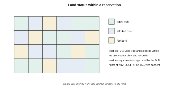
Land within a reservation's boundaries is not all held the same way. Tribal trust land is held by the United States in trust for a tribe. Individual trust land, often called allotted land, is held in trust for individual Indian owners. Restricted fee land is owned by a tribe or individual Indians but cannot be sold or encumbered without federal approval. Fee land, owned outright, may belong to tribal members or to non-members. The mixture comes from history: under the General Allotment Act of 1887 and related laws, many reservations were divided into allotments for individual members, and land found surplus was opened to non-Indian homesteaders, while many allotments later passed out of trust. The result on many reservations is a checkerboard of trust and fee land, and many trust allotments are now owned by dozens or hundreds of heirs in undivided fractions.
Title to trust and restricted land is recorded not at the county but by the Bureau of Indian Affairs, in its Land Title and Records Offices, which keep title status reports for each tract. A title search for a tract of trust land goes to the BIA; a search for fee land within the reservation goes to the county. A surveyor working on a reservation must therefore know the status of every tract the work touches.
Who surveys Indian and federal lands
The BLM is the federal government's official surveyor. Its Cadastral Survey program carries out the official surveys of the public lands and of Indian trust lands, approves surveys made under its authority, and files official plats and field notes, following the Manual of Surveying Instructions. Surveys of trust land boundaries for leases, rights of way, sales and land consolidation must meet federal standards. To expand the pool of qualified surveyors, the BLM created the Certified Federal Surveyor program, which trains and certifies state-licensed private surveyors to carry out surveys on Indian lands under federal standards, with the BLM reviewing and approving their work.
Rights of way over Indian land are granted by the Secretary of the Interior through the BIA under regulations in 25 CFR Part 169, which were substantially revised in a rule that took effect in 2016. A right of way over tribal land generally requires the tribe's consent, and over allotted land the consent of the required share of the owners, as well as an approved survey or legal description. A county right of way, a recorded easement deed or an irrigation district's own instrument does not work on trust land. The district has no canals on a reservation, but its sister water users' association has a rural water pipeline that crosses allotted trust land, and Ruth has worked with a Certified Federal Surveyor on its right-of-way surveys.
Federal survey records are open to everyone, and they are the starting point for any retracement near federal or trust land. The BLM's General Land Office records website provides scanned plats, field notes and patents for most of the public-land states, and the BLM state office in Billings holds Montana's official plats and the records of later resurveys. A patent found online gives the date, the patentee and the land described, and sometimes the reservations, such as the canal right of way under the 1890 act; the field notes give the line descriptions. Leah keeps a copy of each township's plat and notes in the project file, so that every decision on a corner can be traced back to what the original surveyor recorded.
Federal surveys of the public lands
Off the reservations, the BLM's role in the district's work is just as basic. Every PLSS corner in the district was set by a federal survey, and the official plats and field notes are federal records. Where land is still federal, such as Reclamation land along the canals or BLM land on the breaks, the BLM alone can make an official survey of its boundaries, though private surveyors routinely retrace those boundaries for adjoining owners and file their findings. When the BLM carries out a dependent resurvey in a township, the restored corners become official for federal purposes, and private surveyors retracing adjoining private land are expected to follow them unless strong evidence shows otherwise.
For the district's own canals, the federal story continues. Many canals near Great Falls were built by the Reclamation Service early in the 1900s, and title to some of the rights of way may still rest with the United States, while operation passed to the irrigation district by contract. Leah's research must find out, for each reach, whether the right of way is held by the district or by the United States, because a federally held right of way cannot be lost to adverse possession or prescription, and any change to it needs federal approval.
Fractionation and consolidation
Allotment created a problem that survey and title work still meet daily. When an allottee died without a will, the allotment passed to all the heirs in undivided shares, and over several generations many allotments came to be owned by dozens or hundreds of people, some holding tiny fractions. Fractionated tracts are hard to lease, develop or grant rights of way over, because each action needs the consent of a required share of the owners. Federal programs, including the Land Buy-Back Program for Tribal Nations funded by the Cobell settlement, have purchased fractional interests from willing sellers and returned them to tribal trust ownership, and tribes run their own consolidation programs. Each consolidation needs accurate title status and, often, a survey of the tract.
Jurisdiction and the surveyor
Land status also decides which government regulates the land. On trust land, tribal and federal law govern; on fee land within a reservation, the line between tribal and state authority has been the subject of many court decisions, including the US Supreme Court's 1981 decision in Montana v. United States about a tribe's authority over non-members on fee land. A surveyor does not decide those questions, but must know them well enough to ask the right ones: which permits apply, whose consent is needed, and which office records the result. On a single pipeline across a reservation, the answers can change from one quarter section to the next.
The surveys themselves follow federal standards wherever trust land is involved. A boundary of an allotment is a PLSS boundary in most cases, retraced under the Manual of Surveying Instructions, but the decision to accept or restore a corner on trust land is made under the BLM's authority, and the survey is filed with the BLM and the BIA. A private surveyor retracing the fee side of the same line uses the same evidence and the same rules, so the two surveys should agree; when they do not, the surveyors share their evidence before either plat is finished.
Reading the old field books
Federal and private surveyors alike work from field books of the 1800s kept in chains and links. A chain is 66 ft, or 20.1168 m, divided into 100 links. Comparing the record with modern measurements shows how the old chain behaved and helps predict where unfound features, such as a creek crossing recorded in the notes, should be.
# Reading an 1880s field book: chains and links to m, and comparing record with measurement
CHAIN = 20.1168            # m; 100 links to the chain
def ch(chains, links=0):   # chains and links -> m
    return (chains + links / 100.0) * CHAIN

# Mile posts and line notes along an old boundary line (record, in chains and links)
record = [("post 1", 0, 0), ("post 2", 80, 0), ("creek, left bank", 112, 45), ("post 3", 160, 12), ("post 4", 240, 5)]
measured = {"post 2": 1609.88, "post 3": 3221.86, "post 4": 4829.95}   # m, from the 2026 GNSS survey

print("feature             record (m)   measured (m)   ratio")
for name, c, l in record:
    r = ch(c, l)
    m = measured.get(name)
    print(f"{name:18s} {r:10.2f}   " + (f"{m:10.2f}     {m / r:.5f}" if m else "      -"))
ratios = [measured[n] / ch(c, l) for n, c, l in record if n in measured]
k = sum(ratios) / len(ratios)
print(f"mean ratio {k:.5f}: the old chain ran about {(k-1)*1e4:+.1f} cm long per 100 m")
print(f"predicted creek bank from the record and the ratio: {ch(112, 45)*k:.2f} m from post 1")

# Area of a fractional lot recorded as 38.62 acres = ? ha
print(f"38.62 acres = {38.62*0.40468564224:.3f} ha; 10 square chains = 1 acre = {10*CHAIN**2:.2f} m2")feature record (m) measured (m) ratio post 1 0.00 - post 2 1609.34 1609.88 1.00033 creek, left bank 2262.13 - post 3 3221.10 3221.86 1.00024 post 4 4829.04 4829.95 1.00019 mean ratio 1.00025: the old chain ran about +2.5 cm long per 100 m predicted creek bank from the record and the ratio: 2262.71 m from post 1 38.62 acres = 15.629 ha; 10 square chains = 1 acre = 4046.86 m2
Along this line the old measurements run consistently short of the modern ones by about 2.5 parts in 10,000: the chain the 1880s crew used was a little long, so it recorded fewer chains than the true distance. The ratio is not a correction to apply to the boundary, which stays where its corners are; it is a tool for finding things. Using it, the crew predicts the left bank of the creek recorded at 112 chains 45 links at about 2,262.7 m from post 1, and finds the old bank scarp within a meter of that position.
Worked problem
Chains and links to meters
A field book records a corner at 39 chains 87 links from a quarter corner. How far is that in meters and in feet?
Show solution
- \[39.87 \times 20.1168 = 802.06\ \text{m}\]
- \[39.87 \times 66 = 2631.4\ \text{ft}\]
Answer: About 802.06 m, or 2,631 ft.
Working respectfully
Tribal nations are sovereign governments, and their lands are governed by tribal law as well as federal law. Good practice for any survey on or near a reservation starts early: contact the tribe's land department or realty office, explain what the survey is for, obtain any tribal permits and the landowners' consent where needed, ask about cultural and environmental sites to avoid, and share results. Many tribes have their own land staff, GIS offices and surveyors. A surveyor who arrives unannounced on trust land with a crew and a metal detector damages trust that took years to build, however good the measurements are. Results should go back to the tribe as well as to the client: a recovered allotment corner, with its photographs and coordinates, is useful to the tribe's own land office, and sharing it is part of a working relationship that makes the next project easier for everyone.
Common mistakes
MistakeSearching only the county records for land within a reservation.
InsteadFind each tract's status; title to trust land is recorded by the BIA.
MistakeUsing a recorded easement deed for a pipeline across trust land.
InsteadRights of way over Indian land are granted under 25 CFR Part 169 with the required consents.
MistakeIgnoring a BLM dependent resurvey when retracing adjoining private land.
InsteadFollow the official restored corners unless strong evidence shows otherwise.
MistakeUsing the chain ratio to move a boundary.
InsteadUse it to find evidence; corners still control.
Summary and key terms
- Montana has seven reservations and twelve tribal nations; land within them may be tribal trust, allotted trust, restricted fee or fee.
- Title to trust land is recorded by the BIA's Land Title and Records Offices; fee land by the county.
- The BLM makes or approves official surveys of public and Indian trust lands; Certified Federal Surveyors work under its standards.
- Rights of way over Indian land are granted under 25 CFR Part 169 with tribal or owner consent.
- Federally held rights of way, including some Reclamation canals, follow federal rules.
- Work on or near reservations starts with contact, permits, consent and respect for tribal sovereignty.
- Trust land
- Land held by the United States in trust for a tribe or individual Indians.
- Allotment
- A parcel of reservation land assigned to an individual under the allotment laws.
- Fee land
- Land owned outright, which may lie within a reservation.
- Land Title and Records Office
- The BIA office that records title to Indian trust and restricted land.
- Certified Federal Surveyor (CFedS)
- A state-licensed surveyor certified by the BLM to survey Indian lands.
- Dependent resurvey
- A BLM resurvey that restores original corners from the best evidence.
- Chain
- A unit of 66 feet (20.1168 m), divided into 100 links.
Practice problems
Work each problem on paper first, then reveal the answer to check.
Where is title to an allotted trust tract recorded?
Show answer
With the BIA's Land Title and Records Office.
Under which regulations are rights of way over Indian land granted?
Show answer
25 CFR Part 169.
Convert 80 chains 25 links to feet.
Show answer
80.25 × 66 = 5296.5 ft.
Why does it matter whether a canal right of way is held by the United States?
Show answer
Federal land cannot be lost to adverse possession or prescription, and changes need federal approval.
What is the Certified Federal Surveyor program?
Show answer
A BLM program certifying state-licensed surveyors to survey Indian lands under federal standards.
Lesson quiz · 5 questions
Score 60% or more to complete this lesson.
Create a free account to save your progress, take quizzes and earn a certificate.