
GEOM-410 · Lesson 4 of 12 · 20 min
Retracement surveys
A retracement survey re-establishes boundaries that were created by an earlier survey or description. It does not create new boundaries; it finds the old ones. Most of the district's project is retracement: for each canal reach, Ines must find the section and quarter corners and the right-of-way monuments that the original surveys set, decide which are original and undisturbed, restore those that are lost by the rules that apply, and show the result on a plan. This lesson walks through how a retracement is planned and carried out, and how lost corners are restored by proportionate measurement.
Following in the footsteps
The guiding idea of every retracement is that the surveyor follows in the footsteps of the original surveyor. The question is never where the line should be by modern measurement, but where the original surveyor actually ran it. That requires understanding how the original survey was made: the instruments and methods of the time, the order in which lines were run, the instructions the surveyor worked under, and the conditions recorded in the field notes. An 1883 township line run by chain and solar compass will have random errors of a few links per mile and bearings referenced to the true meridian as determined that day; a 1952 right-of-way plan run by transit and steel tape from the section corners will be more precise but will inherit any errors in the corners it started from.
Retracing the footsteps also means working in the right order. A right-of-way plan registered against a quarter section was surveyed from the corners of that quarter as they stood when the plan was made. If one of those corners was later restored in a different position, the right-of-way plan still follows the old position, and the retracing surveyor must find out what the plan's surveyor actually used. Senior surveys and conveyances have priority over junior ones: a later plan cannot move a boundary that an earlier plan or patent fixed.
Research before the field
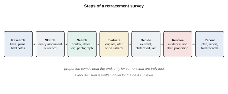
Leah's research for each parcel follows a set routine. She pulls the current certificate of title and any historical titles needed to trace the right of way, the registered plans affecting the quarter, the original township plan and field notes, and any later plans of survey and real property reports filed against adjoining land. She checks the Director of Surveys' records for monument restorations and the Alberta Land Surveyors' Association's resources for known issues in the township. She reads each plan for its ties: which monuments it started from, what it found and what it set. Then she builds a research sketch showing every monument of record in the area, with its source, its type, and what later surveyors said about it.
The research sketch tells the field crew what to look for and where. It also reveals conflicts before anyone digs: two plans that claim to have found the same corner at positions three metres apart, a road widening plan that ties to a monument no one else mentions, a corner that every later survey calls lost. Each conflict is a question to answer in the field. A surveyor who goes to the field without this research will find monuments without knowing what they are, and will be tempted to accept the first post that fits.
Searching and evaluating
In the field, Grant's crew first establishes control, usually by GNSS tied to the provincial or state network, so that every find can be placed in one coordinate system and compared with every record. Then the search begins at each expected corner position, worked out from the research sketch and the best-fitting found monuments nearby. The crew uses metal detectors, probes and shovels, and works carefully: an iron post may lie under 30 cm of cultivated soil, its top bent by a cultivator, and a pit and mound may show only as a faint ring of different grass. Every find is photographed, described and measured before it is touched.
Each find is then evaluated. Is it the type of monument the original survey set, or a later one? Is it marked with a surveyor's number, and whose? Is it plumb and firm in undisturbed soil, or leaning in loose ground beside a fence brace? Does its position agree with the others within the accuracy the original methods could achieve? Does its history, from plans, records and testimony, support its being undisturbed? The answers lead to one of three conclusions for each corner: existent, with an accepted monument; obliterated, with its position recoverable from other evidence; or lost.
Bearings, units and the record
Comparing the record with the ground needs care with the record's own reference frame. Old plans and field notes give bearings referenced to whatever meridian the surveyor used: astronomic north on the day, magnetic north corrected by an estimated declination, or an assumed bearing along one line of the plan. Distances may be in chains and links, in feet, or in metres, measured on the ground surface rather than on a grid. Before a found monument can be judged against the record, the surveyor rotates the record into the modern system using lines between accepted monuments, applies the appropriate scale, and converts units. This is why the best-fit comparison in Lesson 3 includes a rotation and a scale: an old plan that is 40 seconds off modern grid north and 100 parts per million long is not wrong, only different, and the comparison must remove that difference before deciding that any monument is out of place. A surveyor who skips this step can easily condemn a perfectly good original post.
Restoring lost corners by proportion
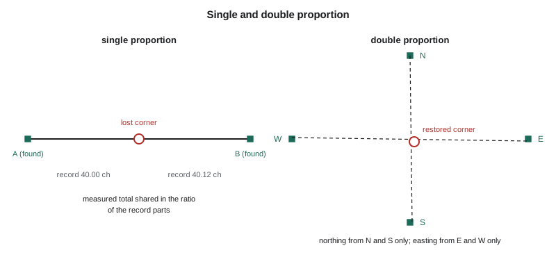
When a corner is lost, the law provides rules for restoring it by measurement from existent corners. The underlying idea is that the original surveyor's errors were spread along the lines in proportion to their length, so a lost corner should be placed so that the record distances on each side of it are stretched or shrunk in the same ratio as the measured distance between the controlling corners. This is called proportionate measurement.
Single proportion is used for corners on a line between two existent corners, such as a quarter corner on a section line. The lost corner is placed on the straight line between them, at a distance from one end that bears the same ratio to the measured total as its record distance bears to the record total. Double proportion is used for corners where lines from four directions meet, such as a section corner in the interior of a township: its north–south position comes from proportion between the existent corners north and south, and its east–west position from proportion between those east and west. The Surveys Act and the Manual of Standard Practice say which method applies to which kind of DLS monument; in some situations the rules call for other methods, such as restoring a corner on a road allowance from both sides, and a surveyor must apply the rule for the specific case.
import math
# 1) Single proportion: restore a lost quarter corner on a line between two found corners
rec_1, rec_2 = 40.00 * 20.1168, 40.12 * 20.1168        # record lengths, chains -> m (west part, east part)
A = (2000.000, 5000.000); B = (3612.410, 5003.882)      # found corners at the two ends (E, N in m)
meas = math.dist(A, B); rec = rec_1 + rec_2
k = rec_1 / rec
lost = (A[0] + k * (B[0] - A[0]), A[1] + k * (B[1] - A[1]))
print(f"record {rec:.3f} m, measured {meas:.3f} m, ratio {meas/rec:.6f}")
print(f"lost quarter corner placed {k*meas:.3f} m from A, at E {lost[0]:.3f}  N {lost[1]:.3f}")

# 2) Double proportion: a lost corner common to four townships or sections,
#    with found control on all four sides (record distances to each, in m)
N = (2804.20, 6611.75); S = (2806.95, 3392.48); W = (1196.30, 5003.10); E = (4415.85, 5006.90)
rN, rS, rW, rE = 1609.34, 1610.15, 1609.34, 1608.90
north_k = rS / (rN + rS)                  # northing from the north-south line only
northing = S[1] + north_k * (N[1] - S[1])
east_k = rW / (rW + rE)                   # easting from the east-west line only
easting = W[0] + east_k * (E[0] - W[0])
print(f"double proportion: E {easting:.3f}  N {northing:.3f}")

# 3) Closure of the retracement traverse (bearings in degrees-minutes-seconds, distances in m)
legs = [((89, 52, 10), 804.66), ((0, 5, 40), 805.10), ((269, 51, 55), 804.42), ((180, 6, 5), 804.98)]
dE = dN = tot = 0.0
for (d, m, s), dist in legs:
    az = math.radians(d + m / 60 + s / 3600)
    dE += dist * math.sin(az); dN += dist * math.cos(az); tot += dist
mis = math.hypot(dE, dN)
print(f"misclosure dE {dE:+.3f} dN {dN:+.3f} = {mis:.3f} m over {tot:.2f} m: 1 in {tot/mis:,.0f}")record 1611.758 m, measured 1612.415 m, ratio 1.000407 lost quarter corner placed 805.000 m from A, at E 2804.998 N 5001.938 double proportion: E 2806.295 N 5002.520 misclosure dE +0.143 dN +0.062 = 0.156 m over 3219.16 m: 1 in 20,671
In the single-proportion case, the record line is 80.12 chains, or 1611.758 m, and the measured distance between the found corners is 1612.415 m, so every record metre is stretched by a factor of 1.000407. The lost quarter corner, 40.00 chains from the west end in the record, is placed 805.000 m from it. In the double-proportion case, the northing comes only from the north and south corners and the easting only from the east and west corners, so the restored corner may not lie exactly on either straight line between opposite corners; that is intended. The traverse that ties the four corners closes to 0.156 m in 3.2 km, about 1 in 20,700, which is ample for the decision but not a substitute for checking the found corners themselves.
Worked problem
Single proportion by hand
Record distances along a section line are 40.00 chains from the west corner to the quarter corner and 40.00 chains from the quarter corner to the east corner. The measured distance between the found west and east corners is 1610.12 m. Where does the lost quarter corner go?
Show solution
- \[D_{\text{rec}} = 80.00 \times 20.1168 = 1609.34\ \text{m}\]
- \[d = 1610.12 \times \frac{40.00}{80.00} = 805.06\ \text{m from the west corner}\]
Answer: At 805.06 m from the west corner, on the straight line to the east corner. Equal record parts give equal measured parts.
Plans, reports and records
A retracement is not finished until its evidence is on the record. The plan shows every monument found, with its description and whether it was accepted, every corner restored and how, and the measured and record distances side by side. A written report, where required or prudent, explains the evidence and the reasoning, especially for decisions that a later surveyor or a court might question. Field notes record everything seen and done, with sketches and photographs. And the surveyor files whatever records the jurisdiction requires.
In Alberta, monuments set or restored are recorded on the registered plan or reported to the Director of Surveys as the Surveys Act and the standards require, so that the provincial record keeps pace with the ground. The Alberta Land Surveyors' Association's standards also set out what a retracement plan and its notes must show. For the district project, each reach will end in a plan that can be registered at the Land Titles Office if the district decides to register or confirm the right of way.
Good records also protect the surveyor. If a neighbour challenges a restored corner ten years later, the field notes, photographs and report are the surveyor's evidence that the decision was made carefully and for good reason. Lesson 10 returns to this point.
Common mistakes
MistakeRestoring a corner by proportion before searching for evidence.
InsteadSearch, evaluate and consider obliteration first; proportion only for truly lost corners.
MistakeUsing modern record distances instead of those of the original survey.
InsteadProportion with the record of the survey that created the corner.
MistakeForcing a double-proportioned corner onto the straight line between opposite corners.
InsteadDouble proportion takes northing and easting from different lines; the result need not lie on either.
MistakeLeaving decisions undocumented.
InsteadRecord every find, decision and reason in notes, plan and report.
Summary and key terms
- A retracement re-establishes existing boundaries by following the original surveyor's footsteps.
- Thorough research comes first: titles or deeds, plans, field notes, earlier retracements and records.
- Each find is evaluated as original, later or disturbed; each corner is existent, obliterated or lost.
- Lost corners are restored by proportion: single on a line, double for interior corners.
- Proportion shares out the difference between measured and record distances in the ratio of the record parts.
- Plans, reports, field notes and filed records preserve the evidence for the next surveyor.
- Retracement survey
- A survey that re-establishes existing boundaries from earlier evidence.
- Proportionate measurement
- Restoring a lost corner so that record distances are scaled to the measured distance between controlling corners.
- Single proportion
- Proportionate restoration along a line between two existent corners.
- Double proportion
- Restoration of an interior corner using separate north–south and east–west proportions.
- Research sketch
- A compilation of every monument of record, with source and history, before field work.
- Senior rights
- The priority of earlier surveys and conveyances over later ones.
- Misclosure
- The amount by which a traverse fails to return to its starting point.
Practice problems
Work each problem on paper first, then reveal the answer to check.
A record line is 1609.34 m; measured, 1608.70 m. Where does a lost corner recorded at 402.34 m from one end go?
Show answer
402.34 × 1608.70 / 1609.34 = 402.18 m from that end.
Why must a retracement follow the order in which the original surveys were made?
Show answer
Later surveys inherit the corners as they stood when they were made; senior rights prevail.
What is the first thing a crew does at a site before searching for monuments?
Show answer
Establish control so every find can be compared in one coordinate system.
Why might a double-proportioned corner not lie on the straight line between its north and south corners?
Show answer
Its easting comes from the east–west line, not the north–south line.
Give two things a retracement plan should show.
Show answer
Monuments found and their descriptions, corners restored and how, and measured beside record distances.
Lesson quiz · 5 questions
Score 60% or more to complete this lesson.
Create a free account to save your progress, take quizzes and earn a certificate.