
GEOM-410 · Lesson 7 of 12 · 20 min
Land titles and registry systems
Every question the district asks ends at the Land Titles Office. Does the district hold a registered right of way over this quarter, or only a caveat? Who is the registered owner the district must deal with? Is there a mortgage whose holder must consent to a new right of way? Alberta's land titles system answers those questions quickly and with a guarantee, and it is one of the main reasons survey work in Alberta looks the way it does. This lesson explains how land registration works in Canada, with a close look at Alberta's Torrens system, and what it means for surveyors.
Two families of registration
Land registration systems fall into two families. In a deeds registry, the government records copies of the documents that transfer and burden land, such as deeds, mortgages and easements, in the order they are received, and anyone can search them. The registry does not say who owns the land; it only records the documents, and the searcher must read the chain of documents back to a good root of title, judge whether each one was valid, and form an opinion on who holds what. In a title registration system, the government examines each transaction and records the result: a register, or certificate of title, that states who owns the land and what interests burden it. The register itself is the evidence of title, and the state stands behind it.
Canada has both. The four western provinces and the territories use title registration, based on the system Robert Torrens introduced in South Australia in 1858, which spread through the British Empire. Ontario historically had two systems side by side, a registry system and a land titles system, and has converted most of its parcels to land titles as part of automating its records. The Atlantic provinces used deeds registries, and Nova Scotia and New Brunswick have since moved to parcel-based registration with greater certainty. Quebec has its own land register under the Civil Code. A surveyor moving between provinces must learn not only a new survey system but a new way of proving who holds land.
The Torrens principles in Alberta
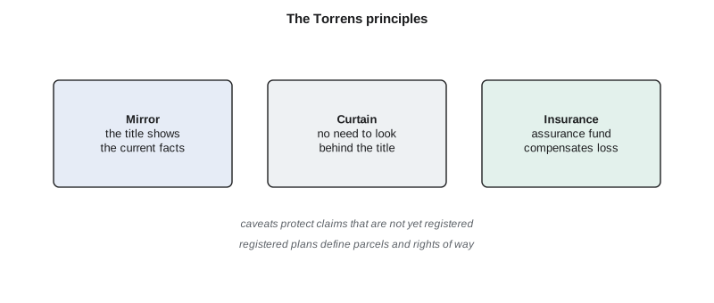
Alberta's system operates under the Land Titles Act and has been in use since 1887, before the province was created. The Land Titles Office keeps the original titles, documents and plans and is responsible for their validity and security. Three principles describe how it works. The mirror principle says that the certificate of title accurately and completely reflects the current facts about a person's title, with some exceptions set out in the Act, such as certain public rights, taxes and fraud. The curtain principle says that the current title contains all the relevant information, so a buyer usually does not need to look behind it at earlier titles. The insurance principle says that if the operation of the system causes someone to lose an interest in land, they can be compensated from the province's assurance fund.
Two practical consequences follow. First, a registered owner's title is, with limited exceptions, indefeasible: it cannot be defeated by an unregistered claim, so a buyer who relies on the register is protected. Second, an interest that is not on the register is at risk. That is why Alberta practice relies on caveats. A caveat, from the Latin for let him beware, is a notice registered against a title that warns anyone dealing with the land that someone other than the registered owner claims an interest. A caveat does not prove the claim, but it protects its priority and forces anyone who wants to deal with the land to address it. Many of the district's older right-of-way agreements were caveated rather than registered by plan, and Leah's first task for each parcel is to sort registered rights of way, caveated agreements and those with nothing on title.
Plans in the land titles system
Because the title, not the deed, is the evidence of ownership, the boundaries in Alberta are tied closely to registered plans. A subdivision is not complete until a plan of survey prepared by an Alberta Land Surveyor is registered, after municipal approval, and new titles are issued that describe the new parcels by lot, block and plan. Rights of way are registered by plan too. The Land Titles Office reviews plans for compliance with the Surveys Act and its own requirements before registering them and assigns each a plan number. Since 1999, plans have been submitted and stored electronically, and the province's spatial information system lets users search survey plans by plan number, legal description or map.
The guarantee covers the title, not the ground. A certificate of title tells a buyer who owns Lot 2, Block 1, Plan 0212345, and what is registered against it. It does not say whether the house is inside the lot, whether the neighbour's garage crosses the line, or whether the fence matches the plan. In Alberta those questions are answered by a Real Property Report (RPR): a legal document prepared by an Alberta Land Surveyor that shows the location of visible improvements relative to the property boundaries, as found at the date of survey, with the surveyor's opinion on any problems. RPRs are commonly required in residential sales, and municipalities review them for compliance with their land use bylaws and stamp them if they comply. The Alberta Land Surveyors' Association's Manual of Standard Practice sets out what an RPR must show.
When the curtain lifts
The curtain principle has limits that matter to the district. When a right of way was granted in the 1920s and the quarter has been transferred many times since, the current title may show the right of way only as a registration number, and the details of what was granted live in the original instrument and plan. Leah retrieves those documents, and sometimes the historical titles too, to see exactly when the district's interest was registered, what it covered, and whether any later transfer excepted it. Historical searches also help when a title was split by an exception, such as a quarter less a road widening and a railway plan, because the sequence of exceptions shows how the parcel was carved up and which plan's corners each later plan relied on. The register makes the present clear; the surveyor still needs the history to retrace the ground.
Mineral titles add another layer. In southern Alberta it is common for the surface and the minerals of a quarter to be held under separate titles, with the minerals belonging to the Crown, to a freehold mineral owner or to the successors of a railway or land company. A canal right of way registered against the surface title does not touch the minerals, and an oil company drilling under the canal deals with the mineral owner and the surface owner, not with the district. The district's GIS records which titles it searched, so that no one assumes a surface search answered a mineral question.
The register is also only as safe as the people who deal with it. Alberta, like other provinces, has strengthened identity checks for registrations after a series of mortgage and title frauds in Canada, and the Land Titles Act deals with how a fraudulently registered title is corrected and who bears the loss. For the district, the lesson is to deal with the registered owner shown on a current title, confirmed close to the date of signing, not with whoever has farmed the land for years.
Not every interest needs to be on the title to bind a buyer. The Land Titles Act lists a small number of exceptions, such as certain public rights of way, rights reserved in the original Crown grant and some statutory interests, that take effect whether registered or not. Road allowances from the original survey are an example a surveyor meets often. The district cannot rely on such exceptions for its canals, but a surveyor must know them, because they explain why a public road can cross a title that never mentions it.
Plan examination is a quiet but important part of the system. Before a plan is registered, the Land Titles Office checks that it closes, that its areas and dimensions agree, that it ties properly to existing surveys and that it meets the plan requirements set under the Surveys Act. A plan with an arithmetic error or a missing tie is returned for correction. That check does not replace the surveyor's responsibility for the boundaries shown, but it does mean that a registered plan has been through an independent review, which is part of why Alberta surveyors and lawyers place so much trust in registered plans.
The district's register search
For the 1,240 legal descriptions in the district's GIS, Leah orders title searches in batches. She records for each title the registered owner, every registered instrument that names the district or its predecessors, every caveat, every mortgage and every plan affecting the quarter. Then she compares that list with the district's own files. In the first batch of 300 titles, 212 show a registered right of way by plan that matches the district's records, 46 show a caveat for an unregistered agreement, 31 show nothing at all, and 11 show a right of way plan for a canal alignment that no longer exists. Each group needs a different response, and the field surveys focus on the last three.
How precise the plan must be
For the new right-of-way plans, the district's specification adopts a precision test widely used in North American boundary practice: the relative positional precision between any two corners, at 95 % confidence, must not exceed 2 cm plus 50 parts per million of the distance between them. Relative precision is about the uncertainty of one corner with respect to another, which is what matters to a neighbour or a future retracement, rather than the uncertainty of each corner in an absolute frame. It comes from the covariance of the coordinate differences in the network adjustment, and the test uses the semi-major axis of the relative error ellipse.
import math
# Relative positional precision between pairs of boundary corners from the network adjustment.
# Each pair: distance (m) and the covariance of the coordinate DIFFERENCE (m^2): var_E, var_N, cov_EN
pairs = {
    "C1-C2": (183.41, 0.0000310, 0.0000270, 0.0000060),
    "C2-C3": (402.77, 0.0000520, 0.0000610, -0.0000110),
    "C3-C7": (61.08,  0.0000900, 0.0000450, 0.0000300),
    "C1-C7": (512.30, 0.0001600, 0.0001250, 0.0000400),
}
K95 = math.sqrt(-2 * math.log(0.05))      # 2.4477: scales a 1-sigma 2D ellipse to 95 % confidence
print("pair     dist (m)  95% semi-major (m)  allowed (m)  result")
for name, (d, ve, vn, cen) in pairs.items():
    mean = (ve + vn) / 2; rad = math.sqrt(((ve - vn) / 2) ** 2 + cen ** 2)
    a95 = K95 * math.sqrt(mean + rad)                 # semi-major axis of the relative error ellipse
    allowed = 0.020 + 50e-6 * d                       # 2 cm plus 50 parts per million
print(f"{name} {d:7.2f} {a95:.4f} {allowed:.4f} {'pass' if a95 <= allowed else 'FAIL'}")pair dist (m) 95% semi-major (m) allowed (m) result C1-C2 183.41 0.0145 0.0292 pass C2-C3 402.77 0.0202 0.0401 pass C3-C7 61.08 0.0251 0.0231 FAIL C1-C7 512.30 0.0334 0.0456 pass
Three of the four pairs pass. The short line from C3 to C7, only 61 m long, fails: its allowance is just 2.3 cm, and C7 was tied by a single short GNSS session under trees. The test catches exactly the kind of weak tie that a plan should not rely on. Grant goes back for a second, independent tie to C7, which brings its relative ellipse well inside the limit.
Worked problem
Allowance for a long line
Two corners are 1,200 m apart. What relative positional precision is allowed under a 2 cm plus 50 ppm rule?
Show solution
- \[\text{allowed} = 0.020 + 50 \times 10^{-6} \times 1200 = 0.020 + 0.060 = 0.080\ \text{m}\]
Answer: 8.0 cm at 95 % confidence. Short lines are held tightly; the ppm term only matters over longer distances.
Common mistakes
MistakeAssuming a certificate of title guarantees where the boundaries are on the ground.
InsteadThe title guarantees the interests registered; the plan and a survey show the ground.
MistakeIgnoring caveats when listing the district's rights.
InsteadCaveats warn of unregistered claims; each needs follow-up.
MistakeTreating a Real Property Report as a new boundary survey.
InsteadAn RPR shows improvements relative to existing boundaries at the date of survey.
MistakeTesting absolute coordinate accuracy when the rule is relative.
InsteadUse the covariance of coordinate differences between the two corners.
Summary and key terms
- Deeds registries record documents; title registration records the result and guarantees it.
- Western Canada uses Torrens title registration; Ontario has largely converted to land titles; the Atlantic provinces have moved to parcel-based systems.
- Alberta's system follows the mirror, curtain and insurance principles under the Land Titles Act, with an assurance fund.
- Caveats protect unregistered claims; registered plans define parcels and rights of way.
- A Real Property Report shows improvements relative to boundaries; it is commonly used in Alberta sales.
- Relative positional precision tests the uncertainty between corners, not each corner alone.
- Torrens system
- A title registration system in which the state records and guarantees ownership.
- Certificate of title
- The register entry stating who owns a parcel and what burdens it.
- Indefeasibility
- The protection of a registered title against unregistered claims.
- Caveat
- A registered notice that someone claims an interest in land.
- Assurance fund
- The provincial fund that compensates people who lose interests through the system.
- Real Property Report (RPR)
- An Alberta survey document showing improvements relative to property boundaries.
- Relative positional precision
- The uncertainty of one surveyed point with respect to another, at stated confidence.
Practice problems
Work each problem on paper first, then reveal the answer to check.
State the three Torrens principles.
Show answer
Mirror, curtain and insurance.
Why are caveats important in Alberta?
Show answer
They protect unregistered claims against later dealings with the land.
What is the 95 % allowance for corners 300 m apart under 2 cm + 50 ppm?
Show answer
0.020 + 0.015 = 0.035 m.
What does a Real Property Report show that a title does not?
Show answer
The location of improvements relative to the boundaries.
Name two provinces that historically used deeds registries.
Show answer
Ontario (registry system), Nova Scotia, New Brunswick and other Atlantic provinces.
Lesson quiz · 5 questions
Score 60% or more to complete this lesson.
Create a free account to save your progress, take quizzes and earn a certificate.