
GEOM-410 · Lesson 12 of 12 · 21 min
Case studies
The district project ends its first season with a stack of files. Most reaches were straightforward: a registered or recorded right of way, monuments found, the canal where the instrument put it. A few were not. This lesson works through four of the harder cases in detail, the way Ruth presents them to the district's board, drawing on everything in the course: tenure and the cadastre, survey systems, evidence, retracement, water boundaries, easements, the land records, subdivision, federal lands, liability and professional judgment. For each case the questions are the same. What does the record say? What did the field work find? What rules apply? What should the district do?
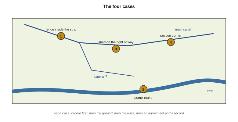
Case 1: the Haugen fence
On the Haugen quarter, the district's right-of-way plan of 1958 puts the north limit of the canal strip 15 m from the canal centreline. The Haugens' fence runs 4 m south of that, inside the strip, for about 600 m, and has done since at least 1968, according to aerial photographs. Mr. Haugen farms right up to the fence and says his father and the district's ditch rider agreed the line in the 1960s. The district wants to know whether it still holds the full strip. The record is clear: the right of way is registered by plan against the title, and the plan's monuments were found and accepted in Lesson 3. The field work is clear too: the fence is 4 m inside the strip. The law decides the rest. Since Alberta's 2022 amendments, long occupation cannot defeat a registered owner's title or a registered interest, so the Haugens' 50 years of farming the strip do not give them the land. An agreed line from the 1960s could matter only if it amounted to a conventional boundary, which needs real uncertainty about the true line; here the registered plan and its monuments were never in doubt. Ruth's advice to the board is that the district holds the full strip, and that the practical question is whether it needs the 4 m. If not, it can leave the fence and give the Haugens a written licence, so that nothing turns on the fence later; if it does, it can ask for the fence to be moved at an agreed time.
Case 2: the pump intake
At the new pump intake, Lesson 5 showed that the river has moved 40 to 100 m south since the 1958 plan, and that dividing the new bank in proportion to old frontage would put the boundary between the Kovac parcel and the district's own parcel 13.5 m east of where a straight extension of the side line would meet it. The pump station is designed to sit in that 13.5 m. Before anything is built, Ruth's team looks for evidence of how the river moved. The aerial photographs from 1950 to 2025 show gradual migration, except in one place: after the 1995 flood, a short reach upstream of the Kovac parcel jumped about 30 m into a new channel. That reach is outside the four parcels, so within them the change appears gradual, and the boundaries have followed the bank by accretion. The method of dividing the new land is a legal question.
The province owns the bed and shore, so the legal bank is also the line between Crown land and the riparian parcels, and the intake pipe that crosses the bed needs provincial authorization under the public lands rules as well as the district's own approvals. Ruth recommends that the district and the Kovacs agree on the boundary between their parcels on the new bank, document it by a plan of survey registered with both owners' consent, and only then site the station; if they cannot agree, the district should site the station clear of the disputed 13.5 m.
Case 3: the machine shed
The landowner's machine shed from Lesson 10 sits 0.6 m inside the right of way. The firm's file showed that its plan was right and that the contractor measured from the water's edge. The district must still decide what to do. Removing a new building over 0.6 m would cost the landowner far more than the strip is worth to the district, and the canal does not need that 0.6 m: the maintenance road runs on the other bank. The district negotiates an encroachment agreement that lets the shed stay for its life, records that it does not change the right of way, requires the owner to keep the canal side clear, and lets the district remove anything that interferes with an emergency repair. Coulee prepares a sketch for the agreement showing the shed's corners and the right-of-way limit, tied to the plan's monuments. The case also prompts a district policy: before any building permit is issued within 30 m of a canal, the municipality or county will refer it to the district, and the district will provide the right-of-way plan to the applicant.
Case 4: the lost section corner
The hardest case is a section corner beside the main canal, which the canal's 1952 right-of-way plan used as its starting point. Every survey since the 1960s has called the corner lost. The four corners around it, north, south, east and west, are existent, so the corner can be restored by double proportion, as in Lesson 4. But during the search, the landowner's son mentions that his grandfather set a fence-corner post on the old stake when he fenced the section line in the 1940s, and the post is still there. Theo computes both positions.
import math
# Case 4: a lost section corner beside the canal, restored and checked before the right-of-way plan is signed
CHAIN = 20.1168
found = {"N": (2804.21, 6611.80), "S": (2806.92, 3392.45), "W": (1196.27, 5003.12), "E": (4415.88, 5006.86)}
rec = {"N": 80 * CHAIN, "S": 80.05 * CHAIN, "W": 80 * CHAIN, "E": 79.98 * CHAIN}
kN = rec["S"] / (rec["N"] + rec["S"]); kE = rec["W"] / (rec["W"] + rec["E"])
corner = (found["W"][0] + kE * (found["E"][0] - found["W"][0]), found["S"][1] + kN * (found["N"][1] - found["S"][1]))
print(f"restored corner E {corner[0]:.3f}  N {corner[1]:.3f}")
# Evidence found later: a fence-corner post the farmer says his father set "on the old stake"
post = (2805.87, 5003.61)
d = math.dist(post, corner)
print(f"fence post is {d:.2f} m from the proportioned position")
print("decision rule: proportion only when no reliable evidence of the original position exists")
print("  -> collect testimony, look for the original pits and mound or the remains of a post, then decide")

# Area of the district's right of way through the quarter after the corner is fixed (30 m strip)
strip = [(corner[0] - 15.0, corner[1]), (corner[0] + 15.0, corner[1]),
         (found["N"][0] + 15.0, found["N"][1] - 805.0), (found["N"][0] - 15.0, found["N"][1] - 805.0)]
a = abs(sum(strip[i][0] * strip[(i+1) % 4][1] - strip[(i+1) % 4][0] * strip[i][1] for i in range(4))) / 2
print(f"right-of-way strip from the corner to the quarter line: {a/10000:.4f} ha")restored corner E 2806.276 N 5002.628 fence post is 1.06 m from the proportioned position decision rule: proportion only when no reliable evidence of the original position exists -> collect testimony, look for the original pits and mound or the remains of a post, then decide right-of-way strip from the corner to the quarter line: 2.4125 ha
The proportioned position is 1.06 m from the fence post. If the post was set on the original stake, the corner is not lost at all but obliterated, and the post is the best evidence of its position; restoring it by proportion would move the corner by a metre and move every boundary that depends on it, including the canal right of way. If the post was set by eye somewhere near a rotted stake, it is weak evidence and proportion may be right. The decision rule from Lesson 3 applies: proportion only when no reliable evidence of the original position exists.
Ines's crew digs carefully around the fence post. Beneath it, at about 40 cm, they find a dark stain in the soil and fragments of decayed wood in a square pattern, the remains of a wooden post; nearby, the outline of a pit appears in the cut face of the soil, matching the pattern the original survey instructions called for at section corners. The fence post sits within 0.15 m of the centre of the stain. The testimony, the stain, the wood and the pit together are reliable evidence of the original position. Ines accepts the corner as obliterated, sets a new monument at the centre of the stain, records the evidence with photographs and sketches, and files the records the jurisdiction requires. The canal right of way is then retraced from the restored corner, and its strip through the quarter, about 2.41 ha by the computation with the proportioned corner, is recomputed from the accepted one; the area changes by less than 0.01 ha, but the strip's limits on the ground move by about a metre, which matters to the farmer and to the district.
Worked problem
Proportion or evidence?
A proportioned corner falls 1.06 m from a fence post said to mark the old stake. Excavation finds the remains of a wooden post 0.15 m from the fence post, with a pit matching the original instructions. Which position should be used, and how far does it differ from the proportioned one?
Show solution
- The remains and pit are physical evidence of the original corner; with the testimony, they show the corner is obliterated, not lost.
- \[\text{difference} \approx 1.06\ \text{m} \pm 0.15\ \text{m}\ \ (\text{between about } 0.9 \text{ and } 1.2\ \text{m})\]
Answer: The evidence position. Proportion applies only to lost corners; here it would have moved the corner about a metre from where the original survey put it.
What the cases have in common
| Case | Record | Field evidence | Rule applied | Recommendation |
|---|---|---|---|---|
| 1 Haugen fence | Right of way of record, monuments accepted | Fence inside the strip since about 1968 | No adverse possession against registered interests in Alberta since 2022 | Confirm holding; licence or move fence by agreement |
| 2 Pump intake | Bank on the 1958 survey | Gradual migration; avulsion only upstream | Accretion moves the boundary; division method is a legal question | Agree and document the boundary before building |
| 3 Machine shed | Right of way of record, plan correct | Shed 0.6 m inside the strip | Encroachment does not change the right of way | Encroachment agreement; permit referral policy |
| 4 Section corner | Corner called lost since the 1960s | Testimony, post remains and pit | Obliterated, not lost: evidence over proportion | Restore at the evidence; retrace the right of way |
Three lessons run through all four cases. First, the record and the ground must both be read, and they must be read in the right order: research first, then field evidence, then the rules. In every case, the answer depended on something only research could find, such as the registration of a plan, a 1995 flood photograph, a contractor's measurement method, or a grandfather's fence. Second, the surveyor's job is to find and document the evidence and to apply the survey rules, while legal questions, such as whether an easement was extinguished or which method divides accreted land, go to lawyers and, if necessary, courts. The surveyor's plan and report make those questions answerable. Third, almost every case ends with an agreement and a record: a licence, a boundary agreement, an encroachment agreement, a filed corner record. The cadastre stays reliable because each resolved question is written down where the next person will find it.
The district's project, one season in
Ruth's report to the board at the end of the season summarizes the work so far. Of the reaches researched, most are secure as recorded; a smaller group rests on agreements or long use that should be put on the record; a few follow canals that have moved off their rights of way and need new instruments; and a handful raise questions that need legal advice, like cases 1 and 2. The report recommends a program for the next three seasons, starting with the reaches where the district's rights are least secure and where development pressure is highest, and it recommends that the district take every subdivision and building referral as a chance to correct its records. It also recommends that the district's GIS store, for every reach, the instrument, the plan, the retracement and any agreement, so that the next board does not have to ask the same question.
For Theo, the season was also preparation. He prepared the retracement report for case 4 under Ruth's supervision, from the research sketch to the final record, and he will use it in his professional examination. For the course, the cases are a reminder that cadastral surveying is a profession of judgment exercised on evidence, under law, on behalf of the public's confidence in where land begins and ends. A good surveyor, like the original surveyors whose footsteps the work follows, leaves the ground and the record clearer than they found them.
Common mistakes
MistakeAnswering a boundary question from the record alone.
InsteadRead the record and the ground, in that order, then apply the rules.
MistakeRestoring a corner by proportion while testimony about its original position is unexplored.
InsteadInvestigate the testimony and dig; evidence comes before proportion.
MistakeTreating every encroachment as something to remove.
InsteadWeigh what the district needs; an agreement may serve better than removal.
MistakeDeciding legal questions in a survey report.
InsteadDocument the evidence and refer legal questions to counsel.
Summary and key terms
- Each case was solved by reading the record, then the ground, then applying the rules.
- Long occupation no longer defeats registered interests in Alberta; agreements resolve practical issues.
- Gradual river change moves boundaries; the method of division and any sudden change need careful evidence.
- Encroachments do not change rights of way; agreements and referral policies manage them.
- An obliterated corner is restored from evidence, even when proportion is available.
- Every resolved question should end in a record the next person will find.
- Encroachment agreement
- An agreement allowing a structure to stay on land subject to another's rights, on stated terms.
- Licence
- Permission to use land that does not create an interest in it.
- Boundary agreement
- An agreement between neighbours documenting where their boundary lies.
- Obliterated corner
- A corner whose monument is gone but whose position is shown by evidence.
- Referral
- A municipal or county practice of sending applications to an affected body for comment.
- Retracement report
- A written account of the evidence and reasoning for a boundary survey.
- Corner record
- A filed record of a corner found, restored or reset.
Practice problems
Work each problem on paper first, then reveal the answer to check.
In case 4, why was the corner not restored by proportion?
Show answer
Testimony, post remains and a pit showed its original position, so it was obliterated, not lost.
In case 3, why did the district not demand the shed's removal?
Show answer
The canal did not need the 0.6 m, and removal would cost far more than the strip is worth; an agreement protects the district.
In case 2, what evidence showed whether the river moved gradually?
Show answer
Aerial photographs from 1950 to 2025, showing an avulsion only upstream of the parcels.
Name the three lessons common to the cases.
Show answer
Read record then ground then rules; leave legal questions to lawyers; end each case with an agreement and a record.
Why should the district store instruments, plans and agreements for every reach in its GIS?
Show answer
So future boards can see the basis of each right without repeating the research.
Lesson quiz · 5 questions
Score 60% or more to complete this lesson.
Create a free account to save your progress, take quizzes and earn a certificate.