
GEOM-410 · Lesson 2 of 12 · 21 min
Land survey systems in Canada
Every field in the irrigation district has a legal description that looks like a code: NE-22-9-22-W4, or LSD 9 of section 15 in township 8, range 21, west of the fourth meridian. These descriptions come from the Dominion Land Survey, the rectangular system Canada laid over the prairies after it acquired Rupert's Land from the Hudson's Bay Company in 1870. To retrace a canal right of way, Ines must first understand the grid it was cut into: how big a section is, where the road allowances run, why townships shrink as they go north and why the lines jog at correction lines. This lesson explains that grid and the other survey systems that divide land in the rest of Canada.
Many systems, one country
Canada has no single survey system. Each colony and later each province developed its own, and the boundaries of land in a Quebec village, an Ontario township, a Nova Scotia farm and an Alberta quarter section were laid out under different rules that still govern them. Along the St. Lawrence, the French seigneurial system produced long narrow lots running back from the river, so that each holding had water frontage; the pattern is still visible from the air. In Ontario, townships were laid out in concessions and lots by several different methods over the late 1700s and 1800s, and a surveyor retracing an Ontario lot must know which method its township used, because each sets different rules for where lost corners go. The Maritime provinces relied largely on metes and bounds descriptions and grants of irregular shape. British Columbia used district lots and its own rectangular township system in the Railway Belt.
On the prairies, the federal government chose a single rectangular system for the whole of the North-West Territories, which then included what became Manitoba, Saskatchewan and Alberta. The Dominion Land Survey began in 1871 and was designed for rapid settlement: every homestead could be described by a few numbers, and surveyors could lay out vast areas quickly with chain and compass, later with transit and chain. The system was revised several times in its early years, so surveyors speak of the first, second and third systems, which differ in the widths and positions of road allowances. Most of southern Alberta, including the irrigation district, was surveyed under the third system, adopted in 1881.
Meridians, ranges and townships
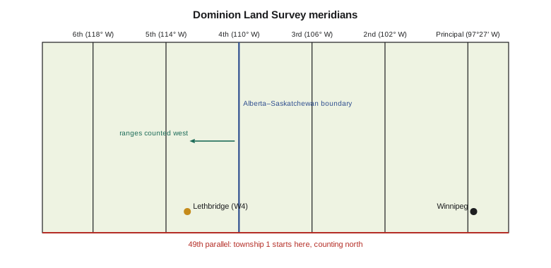
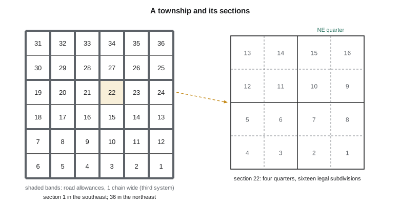
The Dominion Land Survey starts from a series of meridians. The First or Principal Meridian runs just west of Winnipeg, at about 97°27′ W. Further meridians, called the second through sixth, were placed at 102°, 106°, 110°, 114° and 118° west longitude, with a seventh in British Columbia's Peace River Block. The fourth meridian at 110° W became the boundary between Alberta and Saskatchewan. Townships are counted northward from the 49th parallel, the international boundary, starting with township 1. Ranges are counted westward from each meridian, starting again at range 1 on every meridian. A township is nominally six miles square and contains 36 sections, each nominally one mile square, or 640 acres. Sections are numbered from 1 in the southeast corner, running west along the bottom row to 6, then back east along the next row, and so on in a back-and-forth pattern to 36 in the northeast corner.
Each section is divided into four quarter sections of 160 acres, the size of the classic homestead, and into sixteen legal subdivisions (LSDs) of 40 acres each, numbered 1 to 16 in the same back-and-forth pattern starting in the southeast. Alberta's descriptions combine these parts in a fixed order, which the province calls the Alberta Township System (ATS): quarter or LSD, section, township, range and meridian. NE-22-9-22-W4 is the northeast quarter of section 22, township 9, range 22, west of the fourth meridian, which is just east of Lethbridge. The ATS is also the indexing system for land titles, oil and gas wells and many provincial databases.
Road allowances and correction lines
Under the third system, road allowances one chain wide (66 feet, or 20.1168 m) were laid out along all north–south section lines and along every second east–west line. They were part of the original survey and belong to the Crown or, in Alberta, are generally vested in the municipality, not in the adjoining owners. A field that seems to run to the road actually stops at the edge of the road allowance, and a canal built in a road allowance occupies public land, not farmland. Retracing the district's right of way often means finding both the section corner and the road allowance that offsets the survey line from the fence.
Meridians converge as they run north, so a township that is six miles wide at its south boundary is narrower at its north boundary. The survey dealt with this by fixing the width of townships along base lines and correction lines. Base lines were run east–west at intervals of four townships; townships on either side of a base line were laid out at full width from it, so that the shortfall accumulated toward the correction lines that run midway between base lines. At a correction line the north–south lines jog sideways, which is why prairie roads take sudden doglegs. In southern Alberta the convergence across one township is about 17 m, small enough that a farmer never notices it but large enough that a surveyor who ignores it will set corners in the wrong place.
import math
# Dominion Land Survey township near Lethbridge: the theory behind the grid
CHAIN = 20.1168                     # one Gunter's chain in metres (66 ft)
R = 6371000.0                       # mean Earth radius, m (good enough for this check)
sec_side = 80 * CHAIN               # a section is 80 chains (1 mile) on a side, before road allowances
road = 1 * CHAIN                    # third-system road allowances are 1 chain wide
print(f"section side {sec_side:.2f} m; road allowance {road:.4f} m")
print(f"section area {sec_side**2/10000:.2f} ha; legal subdivision (1/16) {sec_side**2/16/10000:.2f} ha")

# Meridians converge: the north edge of a township is shorter than its south edge
def east_west(lat_deg, dlon_deg):
    return math.radians(dlon_deg) * R * math.cos(math.radians(lat_deg))
lat_s = 49.0 + 8 * 6 * 80 * CHAIN / 111_200.0   # south boundary of township 9, ignoring road allowances
lat_n = lat_s + 6 * 80 * CHAIN / 111_200.0
for lat in (lat_s, lat_n):
    print(f"latitude {lat:.4f}: width of 0.1 deg of longitude {east_west(lat, 0.1):.1f} m")
shrink = (math.cos(math.radians(lat_s)) - math.cos(math.radians(lat_n))) * 6 * 80 * CHAIN / math.cos(math.radians(lat_s))
print(f"a township 6 miles wide at its south edge is about {shrink:.1f} m narrower at its north edge")

# Reading an Alberta Township System description
desc = "NE-22-9-22-W4"
q, sec, twp, rge, mer = desc.split("-")
print(f"{desc}: {q} quarter of section {sec}, township {twp}, range {rge}, west of the {mer[1]}th meridian")section side 1609.34 m; road allowance 20.1168 m section area 259.00 ha; legal subdivision (1/16) 16.19 ha latitude 49.6947: width of 0.1 deg of longitude 7192.8 m latitude 49.7815: width of 0.1 deg of longitude 7179.9 m a township 6 miles wide at its south edge is about 17.3 m narrower at its north edge NE-22-9-22-W4: NE quarter of section 22, township 9, range 22, west of the 4th meridian
The code shows the numbers a surveyor keeps in mind: a section is 1609.34 m on a side before road allowances, a legal subdivision is about 16.19 ha, and a township in the Lethbridge area loses about 17 m of width from south to north. Real townships rarely match the theory. The original surveyors worked with chains that stretched, compasses affected by local attraction, and terrain that made chaining hard, and the lines they ran are the lines that count. When a found original monument disagrees with the theory, the monument wins, a rule Lesson 3 explains.
Worked problem
Width shrinkage across a township
A township's south boundary is at latitude 49.6947° N and its north boundary is 9.656 km further north. Estimate how much shorter the north boundary is than the 9656 m south boundary, using a spherical Earth of radius 6371 km.
Show solution
- \[\Delta\varphi = 9656/111\,200 = 0.0868^\circ \quad\Rightarrow\quad \varphi_N = 49.7815^\circ\]
- \[\Delta L = 9656\,\Big(1 - \frac{\cos 49.7815^\circ}{\cos 49.6947^\circ}\Big) = 9656 \times 0.001788 = 17.3\ \text{m}\]
Answer: About 17 m. The survey placed this shortfall in the townships that run up to each correction line.
Monuments of the Dominion Land Survey
The original surveyors marked section and quarter corners with whatever the instructions of the day required: wooden posts in mounds of earth with pits dug beside them, later iron posts, and at township corners larger mounds or stones. Most wooden posts have long since rotted, but the pits and mounds sometimes survive in unbroken prairie, and a careful surveyor can still find them by their pattern and the change in vegetation. Later resurveys and subdivision surveys set iron posts, then steel bars with caps stamped with the surveyor's commission number. Each kind of monument has a recorded description, and knowing what the original surveyor was told to set, and where, is essential to recognizing it when the shovel strikes something.
Legal descriptions in Alberta titles follow a strict pattern. A whole quarter is written as the quarter, section, township, range and meridian; a part of a quarter is often described by reference to a registered plan, such as Lot 2, Block 1, Plan 0212345, or by an exception, such as all that portion of the quarter lying north of the canal right of way on Plan 5240 FX. Some old titles describe land by metes and bounds from a section corner. A title that excepts a road widening, a canal plan and a railway plan from a quarter tells the surveyor exactly which later plans to retrieve, and in what order the quarter was carved up. Leah reads the exceptions first, because they map the history of the parcel.
Original field notes, plans and survey instructions for the Dominion Land Survey are kept by the federal and provincial governments, and Alberta's Director of Surveys keeps the records of later provincial surveys. Leah's research for each district parcel starts with the township plan, which shows the original survey and any later resurveys, and the field notes of the line in question. Field notes record what the surveyor saw and set: distances along the line to creeks, trails and changes in soil, and the bearing trees or mounds at each corner. They are the best guide to where the original survey actually ran.
Other surveys on the prairie
Not everything in the district fits the grid. Before the Dominion Land Survey, Métis and other settlers along rivers in what became Manitoba and Saskatchewan held narrow river lots, and the government surveyed many of these as they were found rather than forcing them into sections; settlement surveys at a few places in Alberta follow the same pattern. Indian reserves were surveyed to their own boundaries under treaty and are part of the Canada Lands survey system, covered in Lesson 9. Railway and irrigation rights of way, highways and townsites were surveyed later as separate plans registered against the sections they cross. A single quarter section near Lethbridge may carry the original section survey, a railway plan, a canal right-of-way plan and a highway widening plan, each of which a retracement must respect.
| System | Where | Typical unit | Retracement clue |
|---|---|---|---|
| Seigneurial lots | Quebec along the St. Lawrence | Long narrow lot from the river | Lot lines run back from the shore at a fixed bearing |
| Township and concession | Ontario | Lot in a concession | The township's survey method sets where lost corners go |
| Metes and bounds grants | Maritime provinces | Irregular grant | Description and adjoiners carry most weight |
| Dominion Land Survey | Prairies, parts of BC | Section, quarter, LSD | Original monuments, road allowances, correction lines |
| River and settlement lots | Along prairie rivers | Narrow lot to the river | Surveyed to existing occupation |
The lesson for the district project is simple to state and slow to apply: every parcel must be retraced in the system that created it. A canal right-of-way plan from 1952 was laid out from the section corners as they stood in 1952, which may not be where the theory or a modern GIS puts them. Ines will retrace from the monuments the 1952 surveyor tied to, in the order the plan was built.
Common mistakes
MistakeAssuming every section is exactly one mile square.
InsteadSections vary; the original monuments, not the theory, define them.
MistakeCounting ranges east from the meridian.
InsteadIn the Dominion Land Survey ranges are counted west from each meridian.
MistakeTreating the road allowance as part of the adjoining farm.
InsteadThe road allowance is public land; the farm boundary is its edge.
MistakeApplying Ontario restoration rules to an Alberta section.
InsteadEach system has its own rules; use the ones that created the parcel.
Summary and key terms
- Canada uses several survey systems: seigneurial lots, Ontario townships, Maritime grants, the Dominion Land Survey and river lots.
- The Dominion Land Survey counts townships north from the 49th parallel and ranges west from each meridian.
- A township is nominally 36 sections; a section is 640 acres, a quarter 160 acres and an LSD 40 acres.
- Third-system road allowances are one chain wide and belong to the public, not to adjoining owners.
- Meridians converge; correction lines absorb the shortfall, and roads jog where they cross them.
- Original monuments and field notes, not the theoretical grid, govern where lines are.
- Dominion Land Survey (DLS)
- The federal rectangular survey of the prairies, begun in 1871.
- Meridian (DLS)
- A north–south reference line from which ranges are counted westward.
- Township
- A block of land nominally six miles square containing 36 sections.
- Legal subdivision (LSD)
- One sixteenth of a section, nominally 40 acres.
- Road allowance
- A strip of public land, one chain wide in the third system, reserved for roads.
- Correction line
- An east–west line where north–south survey lines jog to restore township width.
- Alberta Township System (ATS)
- Alberta's standard form of legal description based on the DLS.
Practice problems
Work each problem on paper first, then reveal the answer to check.
Describe NW-15-8-21-W4 in words.
Show answer
The northwest quarter of section 15, township 8, range 21, west of the fourth meridian.
Which section is in the northeast corner of a DLS township?
Show answer
Section 36.
How wide is a third-system road allowance in metres?
Show answer
One chain, 20.1168 m.
Why do prairie roads jog at correction lines?
Show answer
North–south survey lines are offset there to restore township width lost to convergence.
Which meridian forms the Alberta–Saskatchewan boundary?
Show answer
The fourth meridian, at 110° W.
Lesson quiz · 5 questions
Score 60% or more to complete this lesson.
Create a free account to save your progress, take quizzes and earn a certificate.