
GEOM-410 · Lesson 11 of 12 · 20 min
Licensing: provincial associations and ACLS
Theo has worked at Coulee Geomatics for two years since finishing his geomatics engineering degree. He runs computations, field crews and parts of the district project, but every plan he prepares must be signed by Ruth, because only a registered Alberta Land Surveyor may carry out and certify surveys that define property boundaries in Alberta. This year he starts the last stage toward registration. This lesson explains how land surveyors are licensed in Canada, provincially and federally, and what the path looks like for someone in Theo's position.
Why the profession is licensed
Boundary surveying is licensed because the public cannot easily judge it. A buyer cannot tell a sound retracement from a careless one, and the consequences of a bad one may not appear for decades. So each province gives a self-regulating professional body the power to set entry standards, register qualified surveyors, set standards of practice, investigate complaints and discipline members, in return for a duty to protect the public interest. Only registered members may practise cadastral surveying or use the protected title, and plans for registration at land titles must be signed by one.
Each province and territory has its own body and its own register, reflecting the provincial survey systems and land laws: in Alberta, the Alberta Land Surveyors' Association; in British Columbia, the Association of British Columbia Land Surveyors; in Saskatchewan, the Saskatchewan Land Surveyors' Association; in Ontario, the Association of Ontario Land Surveyors; in Quebec, the Ordre des arpenteurs-géomètres du Québec; and so on. Surveys of Canada Lands are a separate jurisdiction, regulated by the Association of Canada Lands Surveyors under the federal Canada Lands Surveyors Act. Professional Surveyors Canada speaks for the profession nationally.
The academic standard: CBEPS
Most of the Canadian surveying bodies share an academic standard set by the Canadian Board of Examiners for Professional Surveyors (CBEPS). CBEPS publishes a national syllabus covering the knowledge a land surveyor needs, such as survey measurement, adjustment, geodesy, cadastral law, land use planning and professional practice, and assesses candidates against it. A graduate of an accredited geomatics degree is usually exempted from most of the syllabus, while candidates from other backgrounds write CBEPS examinations to fill gaps. A CBEPS certificate of completion is the academic entry point to registration in most provinces and with the ACLS, which makes moving between jurisdictions easier.
Candidates without an accredited degree meet the syllabus by writing CBEPS examinations, subject by subject, usually while working in the profession. The examinations are demanding, and many candidates take several years to finish them alongside a full-time job. Theo's degree, from an accredited geomatics engineering program, exempted him from all of them; a colleague at the firm who trained as a technologist is working through four CBEPS examinations, one each term, with the firm paying her fees and giving her study time before each sitting. Both routes lead to the same certificate, and both are recognized across the provinces.
Registration in Alberta
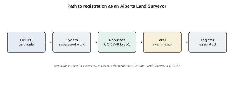
In mid-2026 the Alberta Land Surveyors' Association came under Alberta's Professional Governance Act, which replaced the Land Surveyors Act as its governing statute and brought a common framework for registration, complaints and discipline shared with other professions. With the change came a new registration process for people who have never been registered as land surveyors anywhere. A land surveyor in training must hold a CBEPS certificate of completion, complete two years of land surveying experience under the direction, supervision and control of a registered surveyor, pass four competency courses, and then pass the oral qualifying examination. Experience is reported on a form for each supervising surveyor and tracked by the Association, which tells the candidate when it is complete.
The four competency courses, offered through the University of Calgary's continuing education unit and taught by subject experts, replace much of the earlier articling program's self-study and examinations. They are COR 748 Measurement Sciences and COR 749 Evidence, Standards and Practice 1, run in the fall term starting in September 2026, and COR 750 Communication, Ethics and Professional Governance and COR 751 Evidence, Standards and Practice 2, run in the winter term. Each course is valid for four years. Candidates who were already articling when the new process began follow a transition plan. The oral examination, the same one articling pupils take, tests the candidate's judgment on real survey problems in front of experienced surveyors.
# Theo's path to registration as an Alberta Land Surveyor, and his weekly study hours for the courses
steps = [  # (step, when, evidence of completion)
    ("CBEPS certificate of completion (degree or exams)",          "done",              "certificate on file"),
    ("two years of supervised land surveying experience",          "2025-2027",         "experience forms from each supervisor"),
    ("COR 748 Measurement Sciences",                               "fall term 2026",    "course pass"),
    ("COR 749 Evidence, Standards and Practice 1",                 "fall term 2026",    "course pass"),
    ("COR 750 Communication, Ethics and Professional Governance",  "winter term 2027",  "course pass"),
    ("COR 751 Evidence, Standards and Practice 2",                 "winter term 2027",  "course pass"),
    ("oral qualifying examination",                                "after all of the above", "pass, then registration"),
]
for s, when, ev in steps:
    print(f"{s:58s} {when:22s} ({ev})")
# Weekly hours for each term's two courses, weighted by how weak Theo rates himself (1 strong ... 5 weak)
weak = {"fall": {"COR 748": 2, "COR 749": 5}, "winter": {"COR 750": 3, "COR 751": 5}}
budget = 10.0   # hours per week he can give to study while working
for term, courses in weak.items():
    tot = sum(courses.values())
print(term + ": " + ", ".join(f"{c} {budget * w / tot:.1f} h/week" for c, w in courses.items()))CBEPS certificate of completion (degree or exams) done (certificate on file) two years of supervised land surveying experience 2025-2027 (experience forms from each supervisor) COR 748 Measurement Sciences fall term 2026 (course pass) COR 749 Evidence, Standards and Practice 1 fall term 2026 (course pass) COR 750 Communication, Ethics and Professional Governance winter term 2027 (course pass) COR 751 Evidence, Standards and Practice 2 winter term 2027 (course pass) oral qualifying examination after all of the above (pass, then registration) fall: COR 748 2.9 h/week, COR 749 7.1 h/week winter: COR 750 3.8 h/week, COR 751 6.2 h/week
Theo's plan puts the fall courses in the 2026 term, the winter courses in 2027, and the oral examination after his two years of experience are complete. He rates himself weakest in evidence and standards, so the plan gives the two evidence courses about two-thirds of his study hours in each term. Ruth adds one thing the plan does not show: she will have him prepare, under her supervision, the retracement report for one complete district reach, because the oral examination will ask him to defend exactly that kind of judgment.
Worked problem
Splitting study time
A candidate has 9 hours a week for two courses and rates herself 2 on one and 4 on the other, where higher means weaker. How should she split her time?
Show solution
- \[\text{course 1} = 9 \times \frac{2}{2+4} = 3\ \text{h}\]
- \[\text{course 2} = 9 \times \frac{4}{2+4} = 6\ \text{h}\]
Answer: 3 hours and 6 hours a week. Weighting by weakness puts the effort where it is needed.
What the experience must teach
Two years of supervised experience is not just time served. It is meant to show that the candidate can bridge theory and practice: research a parcel's history, plan and run a retracement, evaluate found monuments, restore lost ones by the rules, prepare plans that meet the standards, and explain the decisions. Ruth keeps a list for Theo of the kinds of work he must see and do before she will sign his experience forms: retracements in the DLS and in at least one plan of subdivision, a water boundary, a road widening, a right-of-way plan, a Real Property Report, a descriptive plan, and the preparation of plans for registration. She also makes sure he spends time with the Land Titles Office's plan requirements and sees plans returned for correction, because learning why a plan fails examination teaches as much as drafting one that passes.
Supervision is a responsibility for the supervising surveyor too. A registered surveyor who signs a candidate's work, or certifies a candidate's experience, is vouching for it. Ruth reviews Theo's research sketches and field decisions before they go into any plan, and she records her review, partly to protect the firm and partly because explaining her reasons is the best way to teach them.
The oral examination
The oral qualifying examination is the profession's last check that a candidate can be trusted to work alone. Experienced surveyors question the candidate on real problems: a found post that does not fit, a conflict between two plans, a client who wants a boundary moved, a river that has shifted, a request to sign a plan prepared by someone else. The examiners are less interested in the right answer to a computation than in the candidate's reasoning, judgment and awareness of the limits of their role. Candidates prepare by working through cases with their supervisors, reviewing the Manual of Standard Practice and the Surveys Act, and practising explaining their decisions aloud.
Ethics and the firm
Registration brings duties beyond technical competence. The Association's code of ethics and conduct requires members to hold the public interest first, to practise only within their competence, to avoid and disclose conflicts of interest, to be honest and objective, and to respect the work of other surveyors, including by not criticizing it unfairly. Survey firms offering cadastral services to the public need a permit to practise from the Association, and a registered surveyor must take responsibility for the firm's professional work. For a candidate, this means that the habits formed during the experience years, such as careful records, honest reporting and respect for other surveyors' evidence, become professional obligations on the day of registration.
Canada Lands Surveyors
Surveys of Canada Lands, including reserves, national parks, the territories and offshore areas, must be made by a Canada Lands Surveyor licensed by the ACLS. The ACLS also requires a CBEPS certificate and sets its own experience and professional examination requirements, focused on the Canada Lands survey system, its standards and the legislation that governs interests in Canada Lands. Many surveyors in western Canada hold both a provincial registration and an ACLS licence, so that they can serve clients on both sides of a reserve boundary. Ruth does not; when the district's work touches a reserve, the firm works with a Canada Lands Surveyor, as Lesson 9 described.
Practising across borders
A registered surveyor who moves to another province does not start again from nothing. The Canadian Free Trade Agreement and agreements among the surveying bodies support labour mobility, and a surveyor registered in one province can usually register in another by showing knowledge of the new province's survey system, legislation and standards, often by examination. Practice in the United States requires a state license, and Canadian surveyors who work near the border sometimes hold one. Within a province, a firm offering cadastral surveying must usually hold a permit from the association, and at least one registered surveyor must take responsibility for its work.
Continuing competence
Registration is not the end of learning. Surveying associations require members to keep their competence current through continuing professional development: courses, conferences, self-study and mentoring, reported each year or cycle. The standards themselves change, as do the tools, from GNSS networks to the datums that underpin them, and the law changes too, as Alberta's 2022 abolition of adverse possession and its 2026 move to the Professional Governance Act show. A surveyor who registered in 2000 and stopped learning would be retracing boundaries under rules that no longer apply.
Common mistakes
MistakeSigning a plan for registration before being registered.
InsteadOnly a registered Alberta Land Surveyor may sign it; candidates work under supervision.
MistakeAssuming a provincial registration covers reserve land.
InsteadSurveys of Canada Lands need a Canada Lands Surveyor licence.
MistakeTreating the competency courses as a formality.
InsteadThey prepare for the oral examination, which tests real professional judgment.
MistakeAssuming registration in one province allows practice in another.
InsteadRegister in each province where you practise, usually after showing local knowledge.
Summary and key terms
- Each province licenses land surveyors through a self-regulating association; the ACLS licenses Canada Lands Surveyors.
- CBEPS sets a shared national academic standard and issues certificates of completion.
- Since mid-2026 the ALSA operates under the Professional Governance Act.
- Alberta registration requires a CBEPS certificate, two years of supervised experience, four competency courses and an oral examination.
- Mobility between provinces is supported, but each jurisdiction requires local knowledge.
- Continuing professional development keeps registered surveyors current.
- Alberta Land Surveyor (ALS)
- A surveyor registered with the ALSA to carry out cadastral surveys in Alberta.
- CBEPS
- The Canadian Board of Examiners for Professional Surveyors, which sets the national academic standard.
- Canada Lands Surveyor (CLS)
- A surveyor licensed by the ACLS to survey Canada Lands.
- Professional Governance Act
- The Alberta statute under which the ALSA and other professions are regulated.
- Competency course
- One of four required courses in the ALSA registration process.
- Oral qualifying examination
- The final ALSA examination of a candidate's professional judgment.
- Continuing professional development
- Ongoing learning required to keep registration current.
Practice problems
Work each problem on paper first, then reveal the answer to check.
What are the four steps to registration as an ALS for a new candidate?
Show answer
CBEPS certificate, two years of supervised experience, four competency courses and the oral examination.
Who licenses surveyors to work on reserves?
Show answer
The Association of Canada Lands Surveyors.
What does CBEPS do?
Show answer
Sets the national academic syllabus and assesses candidates, issuing certificates of completion.
Why must a surveyor keep learning after registration?
Show answer
Standards, tools, datums and the law change.
Under which Act has the ALSA operated since mid-2026?
Show answer
The Professional Governance Act.
Lesson quiz · 5 questions
Score 60% or more to complete this lesson.
Create a free account to save your progress, take quizzes and earn a certificate.