
GEOM-410 · Lesson 3 of 12 · 22 min
Evidence and boundary law
On the third day of field work, Grant's crew finds five iron posts along the old canal right of way on the Haugen quarter. Four of them fit the 1958 plan to within a centimetre after a best-fit transformation. The fifth sits three-quarters of a metre away from where the others say it should be, beside a fence brace and a cattle trail. Is it the original post, knocked sideways by cattle and pushed back by a farmer? A replacement set by someone who measured from the wrong place? Or the true corner, with the other four slightly off? The answer is not in the coordinates alone. It depends on what the evidence shows and on the rules of law that tell a surveyor how to weigh it. This lesson sets out those rules.
Boundaries are questions of evidence
A property boundary is where the parties to the original conveyance or survey intended it to be, as shown by the best available evidence. It is not where a modern measurement would put it if the survey were done again, and it is not where the area or the theory says it ought to be. When a parcel was created by a survey, the boundaries are where that survey placed them on the ground, as marked by its monuments. When a parcel was created by a description without a survey, the boundaries are where the words, read in light of the circumstances at the time, put them. In both cases the surveyor's job is historical: to reconstruct what was done, from what survives.
Evidence comes in many forms. Physical evidence includes monuments, their remains, pits and mounds, bearing trees, fences, hedges, old roads and buildings. Documentary evidence includes plans and plats, field notes, deeds, titles, previous surveys, aerial photographs, and the correspondence and diaries of earlier surveyors. Testimony includes what landowners, neighbours and former workers remember about where corners were and when fences were built. Measurement evidence includes the distances and bearings between found monuments, compared with those of record. A surveyor collects all of it, judges each piece for reliability and relevance, and forms an opinion in which the pieces fit together.
The order of importance
Courts in both Canada and the United States have developed, over a long history of boundary cases, a general order in which conflicting elements of a description or survey are usually given weight. The order is a guide to intent, not a mechanical rule; where it would defeat the evident intention of the parties, it gives way. With that caution, the common order is: natural boundaries and original monuments first, then artificial monuments and the lines of adjoining parcels, then courses (bearings or directions), then distances, and last, area. The logic is that people are least likely to be mistaken about what they could see and touch, and most likely to be mistaken about numbers they wrote down.
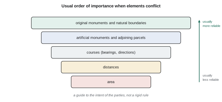
An original monument is one set by the surveyor who created the boundary, in the course of that survey. If it can be identified and is undisturbed, it controls, even if the distances to it are wrong. A purchaser bought the land as marked on the ground, not as written in a field book, and the law protects that reliance. A monument set later, in a retracement, is evidence of where an earlier surveyor believed the original was, and it is only as good as that surveyor's work. Distinguishing original from later monuments is therefore one of the most important skills in boundary surveying, and it rests on knowing the instructions, materials and markings of each period.
Canadian courts have long held that monuments planted by the original surveyor govern over measurements. A Supreme Court of Canada decision of the 1880s, Grasett v. Carter, is often cited for the principle, and every province's surveys legislation builds on it: in Alberta, the Surveys Act treats monuments placed in an original survey as defining the boundaries they mark. A surveyor who finds an undisturbed original post holds it, records it and shows it on the plan, even if it is a metre from where the plan's measurements put it.
Obliterated and lost corners
When the original monument cannot be found, the surveyor must decide whether its position can still be determined from other evidence. If acceptable evidence of the original position survives, such as witness marks, bearing trees, the remains of a pit and mound, a fence built to the original corner, or reliable testimony from someone who saw it, the corner is said to be obliterated, and the surveyor restores it at the position the evidence shows. Only when no such evidence exists is a corner truly lost, and then it is restored by measurement from other corners, usually by proportion as Lesson 4 explains. The distinction matters, because restoring by proportion a corner whose position was in fact known from other evidence moves the boundary.
Alberta's Surveys Act sets out how lost monuments of the original Dominion Land Survey and of later plans are to be re-established, and the Alberta Land Surveyors' Association's Manual of Standard Practice gives detailed guidance. The principle is the same as everywhere: proportion is a last resort, used only after a thorough search for evidence of the original position has failed.
Occupation, fences and agreements
Fences, hedges and walls are not boundaries in themselves, but they can be strong evidence of where a boundary was believed to be, especially if they were built soon after the original survey, when the monuments were still visible. A fence built in 1920 to a post that has since vanished may be the best evidence of where that post stood. A fence built in 1990 by a farmer who guessed is weak evidence. The surveyor investigates: who built it, when, from what, and whether neighbours treated it as the line. That investigation often matters more than any measurement.
Sometimes neighbours who were unsure where their common boundary lay agreed on a line and lived by it for many years. Courts in both countries have recognized such conventional or agreed boundaries in some circumstances, binding the owners and their successors even if the line differs from the original survey. The requirements vary by jurisdiction and are usually strict: genuine uncertainty about the true line, an agreement, and conduct consistent with it over time. A surveyor who suspects a conventional boundary does not decide the question, but documents the evidence and flags the possibility for the client and their lawyer.
Adverse possession is a different doctrine: a person in open, exclusive and continuous possession of land for a statutory period could, under the old law, extinguish the owner's title. The Supreme Court of Canada summarized the traditional requirements in Nelson (City) v. Mowatt in 2017, a British Columbia case about a lot that a family had used for decades, where the claim failed because the trial judge found a gap in possession. Alberta abolished adverse possession against registered owners with the Property Rights Statutes Amendment Act, 2022, which received royal assent in December 2022. Since then, a person who has occupied a neighbour's land, even for decades, cannot acquire title by that occupation. Instead, under the amended Law of Property Act, a court may deal with a lasting improvement on the wrong land by ordering it removed, ordering the land sold to the improver at a price the court fixes, granting an easement, or ordering compensation. Claims already under way under the old rules may proceed. For the district, this means a farmer's shed that has stood on the canal right of way since 1975 does not give the farmer title to the strip, though it may still need to be resolved.
Weighing the posts on the Haugen quarter
Back to the five posts. Theo computes a best-fit similarity transformation from the 1958 plan coordinates to the field coordinates, first using all five posts, then leaving out the one that fits worst. A transformation with rotation, scale and shift allows for the old plan's own bearing reference and chaining scale, so that only real disagreements show up as misfits.
import math
# Record coordinates (1958 plan, local plan grid) and field coordinates of the found iron posts
record = {"A": (0.00, 0.00), "B": (402.34, 0.00), "C": (402.34, 201.17), "D": (0.00, 201.17), "E": (201.17, 201.17)}
found  = {"A": (5000.012, 2999.992), "B": (5402.347, 3000.157), "C": (5402.289, 3201.331),
          "D": (4999.917, 3201.172), "E": (5201.725, 3200.841)}

def fit(names):
    """Best-fit 2D similarity (rotation, scale, shift) from record to field, by least squares."""
    n = len(names)
    xr = sum(record[p][0] for p in names) / n; yr = sum(record[p][1] for p in names) / n
    xf = sum(found[p][0] for p in names) / n;  yf = sum(found[p][1] for p in names) / n
    sa = sb = ss = 0.0
    for p in names:
        x, y = record[p][0] - xr, record[p][1] - yr
        X, Y = found[p][0] - xf, found[p][1] - yf
        sa += x * X + y * Y; sb += x * Y - y * X; ss += x * x + y * y
    a, b = sa / ss, sb / ss
    def to_field(p):
        x, y = record[p][0] - xr, record[p][1] - yr
        return xf + a * x - b * y, yf + b * x + a * y
    return a, b, to_field

def report(names, label):
    a, b, to_field = fit(names)
    print(f"{label}: scale {(math.hypot(a, b)-1)*1e6:+.0f} ppm, rotation {math.degrees(math.atan2(b, a))*3600:+.1f} arc-seconds")
    worst = None; mis = {}
    for p in record:
        E, N = to_field(p)
        d = math.hypot(found[p][0] - E, found[p][1] - N)
        mis[p] = d
        print(f"   {p}: misfit {d:.3f} m" + ("" if p in names else "   (not used in the fit)"))
        if p in names and (worst is None or d > worst[1]): worst = (p, d)
    return worst, mis

worst, _ = report(list(record), "all five posts")
if worst[1] > 0.10:
    keep = [p for p in record if p != worst[0]]
    _, mis = report(keep, f"without post {worst[0]}")
print(f"post {worst[0]} sits about {mis[worst[0]]:.2f} m from where the others say it should be: treat it as suspect, not as proof")all five posts: scale -123 ppm, rotation +32.9 arc-seconds A: misfit 0.121 m B: misfit 0.136 m C: misfit 0.175 m D: misfit 0.189 m E: misfit 0.574 m without post E: scale +34 ppm, rotation +82.1 arc-seconds A: misfit 0.008 m B: misfit 0.011 m C: misfit 0.011 m D: misfit 0.007 m E: misfit 0.747 m (not used in the fit) post E sits about 0.75 m from where the others say it should be: treat it as suspect, not as proof
With all five posts the misfits are spread over every post, from 0.12 m to 0.57 m, because the one bad post drags the fit. Without post E, the other four fit to within about a centimetre, and post E sits about 0.75 m from where they say it should be. The arithmetic shows that post E is inconsistent with the rest of the survey. It does not show that post E is wrong. Ines examines it: the post is the right type for 1958, but its stamp is worn and the ground around it is disturbed; the fence brace beside it was replaced in the 1990s, according to Mr. Haugen; and the 1958 field notes describe the post as set in undisturbed sod. Taken together, the evidence suggests the post was knocked out and reset by eye when the brace was built. Ines treats it as disturbed, restores the corner from the other four, records her reasons in her field notes and on the plan, and leaves the old post in place, noted, so that anyone who disagrees later can see the evidence for themselves.
Worked problem
Choosing between a monument and a measurement
A plan shows a lot line 100.00 m long between two corners. A surveyor finds both original iron posts undisturbed, 100.42 m apart. A neighbour argues that the line should be 100.00 m. Where is the corner?
Show solution
- The original posts are undisturbed and were set in the original survey, so they define the corners.
- The record distance of 100.00 m is evidence of intent, but it ranks below the monuments it describes.
- \[\text{difference} = 100.42 - 100.00 = 0.42\ \text{m}\ \ (0.42\,\%)\]
Answer: At the posts. The 0.42 m difference is shown on the plan as the measured distance beside the record distance.
The surveyor's role, and its limits
Boundary decisions are professional opinions. A surveyor forms one from the evidence, shows it on a plan, explains it in a report and stands behind it. A surveyor who finds conflicting evidence that cannot be reconciled, such as two sets of monuments for the same corner, each with some claim to be original, should show both, explain the conflict and advise the client that the matter may need to be settled by agreement or by a court. It is never the surveyor's role to resolve a genuine conflict by setting a third monument halfway between, or to move a boundary to suit a client. The surveyor serves the evidence, and through it the public's confidence in the cadastre.
Common mistakes
MistakeSetting a corner where the record distances put it, ignoring an undisturbed original monument.
InsteadThe original monument controls; show the measured distance beside the record.
MistakeTreating any found post as original.
InsteadCheck its type, markings, setting and history; later monuments are only evidence of where someone thought the corner was.
MistakeCalling a corner lost without a thorough search for other evidence.
InsteadSearch for witnesses, pits, fences and testimony first; proportion is a last resort.
MistakeDeciding a conventional boundary or possession claim yourself.
InsteadDocument the evidence and refer the legal question to the client's lawyer.
Summary and key terms
- A boundary is where the original survey or conveyance put it, as shown by the best available evidence.
- Evidence is physical, documentary, testimonial and measured; the surveyor weighs all of it.
- The usual order of importance is monuments and natural boundaries, adjoiners, courses, distances, then area.
- Undisturbed original monuments control over measurements.
- An obliterated corner is restored from evidence; only a lost corner is restored by proportion.
- Alberta abolished adverse possession against registered owners in 2022; courts now deal with improvements on the wrong land.
- Original monument
- A monument set by the surveyor who created the boundary, in that survey.
- Obliterated corner
- A corner whose monument has gone but whose position can be recovered from evidence.
- Lost corner
- A corner whose position cannot be recovered from evidence and must be restored by measurement.
- Order of importance
- The usual ranking of conflicting elements of a description, as a guide to intent.
- Conventional boundary
- A line agreed by neighbours who were uncertain of the true line, recognized in some circumstances.
- Adverse possession
- Acquisition of title by long, open, exclusive possession, where the law still allows it.
- Testimony
- Evidence given by people about where monuments or lines were.
Practice problems
Work each problem on paper first, then reveal the answer to check.
Rank these from usually most to least weighty: distance, original monument, area, bearing.
Show answer
Original monument, bearing, distance, area.
What is the difference between an obliterated and a lost corner?
Show answer
An obliterated corner can be recovered from other evidence; a lost corner cannot and is restored by measurement.
A fence was built in 1921 to a corner post that has since rotted away. How might it be used?
Show answer
As evidence of the original corner position, if its history and construction support that.
Why does a best-fit transformation help when comparing found posts with a plan?
Show answer
It removes the plan's own rotation, scale and shift, so only real disagreements show as misfits.
What should a surveyor do with two conflicting sets of monuments for one corner?
Show answer
Show both, explain the conflict and advise that it may need agreement or a court.
Lesson quiz · 5 questions
Score 60% or more to complete this lesson.
Create a free account to save your progress, take quizzes and earn a certificate.