
GEOM-410 · Lesson 7 of 12 · 20 min
Deeds, records and title insurance
Every question the district asks ends at a county courthouse. Does the district hold a recorded easement over this quarter, or only an old agreement in a filing cabinet? Who owns the land today, and through what chain of deeds? Is there a mortgage whose lender must consent to a new easement? In Montana, as in most states, no government office answers those questions with a guarantee. The public record holds the documents, and title companies and lawyers interpret them and insure the result. This lesson explains how that system works and how it shapes the surveyor's role, including the ALTA/NSPS Land Title Survey.
Recording, not registering
Land records in the United States are kept by counties under each state's recording laws. In Montana, deeds, mortgages, easements, plats and certificates of survey are recorded with the county clerk and recorder, who stamps each document with the date and time of receipt and a reference number and indexes it, traditionally by the names of the grantor and grantee and increasingly by parcel. The recorder does not judge whether a deed is valid or whether the grantor owned the land. The record gives notice to the world of what has been recorded, and it is up to anyone dealing with the land to search the record and draw conclusions.
Recording acts decide who wins when the same land is conveyed twice. States follow one of three patterns. Under a race statute, whoever records first wins. Under a notice statute, a later buyer who paid value and had no notice of an earlier unrecorded deed wins. Under a race-notice statute, a later buyer wins only if they had no notice and also recorded first. Most states use notice or race-notice statutes. Whatever the pattern, the practical lesson is the same: an unrecorded easement is at risk against a buyer who did not know of it, and the district's unrecorded agreements are exactly that risk.
Chains of title and title insurance
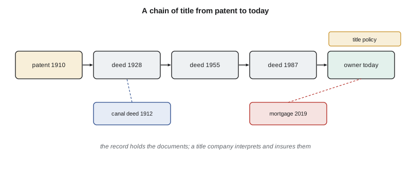
To decide who owns a parcel, a searcher traces its chain of title: the sequence of conveyances from the original federal patent, or another good root, down to the current owner, checking that each grantee became the next grantor and noting every easement, mortgage, lien and restriction recorded along the way. Because no government stands behind the result, buyers and lenders protect themselves with title insurance. A title company searches the record, issues a commitment listing the requirements to be met and the exceptions it will not insure, and at closing issues a policy insuring the owner or lender against loss if title turns out to be other than as insured, subject to those exceptions.
The exceptions matter to surveyors. A standard owner's policy excepts matters that an accurate survey would disclose, such as encroachments, boundary line disputes and easements visible on the ground but not of record. To remove that survey exception, the insurer and the lender usually require a survey to their standard. A few states once offered Torrens-style title registration, and a small number of counties, notably in Minnesota, still maintain it for some parcels, but in Montana title rests on the record and on insurance.
The ALTA/NSPS Land Title Survey
For commercial transactions, the usual standard is the ALTA/NSPS Land Title Survey, prepared to the Minimum Standard Detail Requirements adopted jointly by the American Land Title Association and the National Society of Professional Surveyors. The current version, the 2026 standards, took effect on February 23, 2026, replacing the 2021 version. The standards require the surveyor to review the title commitment and the record documents provided, to locate and show the boundaries, the improvements, the easements of record that can be located and evidence of unrecorded use, and to certify the survey to the parties named. An optional list, Table A, lets the client order additional items, such as flood zone classification, zoning information, utilities or building measurements. The standards also set a precision requirement for boundary corners, expressed as relative positional precision.
The certification on an ALTA/NSPS survey names the parties who may rely on it, such as the buyer, the lender and the title company, and states the standards and Table A items to which the survey was made. That certification defines to whom the surveyor owes the survey's accuracy, a point Lesson 10 returns to when it discusses liability to third parties. A surveyor who adds names to the certification without thought widens the circle of people who can claim against the survey.
An ALTA/NSPS survey is not the same as a boundary survey for a homeowner, though it includes one. It is built around the title commitment: for every exception listed in Schedule B, the surveyor states whether it affects the property and, if it can be located, shows it on the plat. That is why the district's lawyer asks for ALTA/NSPS surveys on the two reaches where it plans to buy land outright for a new pump station and a realigned canal.
Plats, certificates of survey and descriptions
Surveys enter the Montana record in two main forms. A subdivision plat, approved under state law and the local subdivision regulations, creates lots that can then be conveyed by lot and block. A certificate of survey records a boundary survey, or a division of land that is exempt from subdivision review, and shows the parcels, monuments and measurements found or set. State law requires final plats and certificates of survey to be filed with the county clerk and recorder before the land they show is transferred, and recording a plat establishes the identity of the lands shown on it. A deed may then describe a parcel by reference to the recorded certificate of survey, which is far more reliable than a long metes and bounds description copied from one deed to the next with each copyist's errors.
Old deeds in the district often describe parcels by aliquot parts with exceptions, such as the NE1/4 of section 22 except the canal right of way of the United States and except the county road. Each exception points to another document, and the order of the conveyances decides which owner bore which exception. Leah traces those exceptions back to their sources, because a canal strip that was excepted from a 1928 deed may still belong to the grantor's heirs if the district never received a deed for it, or to the United States if the strip was reserved by the patent or acquired by the Reclamation Service and never transferred. Untangling which is often the slowest part of the project.
The title company's commitment for each parcel the district plans to buy lists the recorded easements, mortgages, liens and reservations in Schedule B. The district's lawyer asks Ruth to plot every locatable exception so that the board can see, on one drawing, what lies inside the proposed pump station site: a 1912 Reclamation canal right of way, a buried telephone line easement from 1964, and a road easement to the county. That plot is part of the ALTA/NSPS survey and shapes the purchase.
Montana also maintains a statewide cadastral layer, built from county records by the Montana State Library, that shows parcel boundaries, owners and tax information for the whole state. It is invaluable for planning the district's research, because it links each field to a parcel number and an owner of record, but it is a map for finding documents, not a substitute for them. Its lines are compiled from deeds, plats and certificates of survey of varying quality and fitted to the PLSS framework, and they can be tens of meters from the boundaries on the ground. Many counties now accept electronic recording, and the indexes increasingly allow searches by parcel as well as by name, which makes chains of title faster to trace. For older documents, Leah still goes to the clerk and recorder's books, where a 1912 deed may be a handwritten copy whose description must be read carefully, word by word, against the original if the copy is unclear.
The district's record search
For the 1,240 legal descriptions in the district's GIS, Leah works with a title company to obtain ownership and encumbrance reports in batches. She records the current owner, every recorded instrument that names the district or its predecessors, every mortgage and every plat or certificate of survey affecting the quarter, and the federal patent, which may reserve canal rights of way. In the first batch of 300, 198 show a recorded easement or deed that matches the district's records, 52 rely on the patent reservation or an unrecorded agreement, 39 show nothing at all, and 11 show an easement for a canal alignment that no longer exists. Each group needs a different response, and the field surveys focus on the last three.
How precise the corners must be
The ALTA/NSPS standards define relative positional precision as the length of the semi-major axis of the error ellipse representing the uncertainty of the position of one boundary corner with respect to another, at 95 % confidence, and have long set the allowable value at 2 cm (0.07 ft) plus 50 parts per million of the distance between the corners. Relative precision is what matters to a neighbor or a future retracement. It comes from the covariance of the coordinate differences in a least-squares network adjustment, and the district adopts the same test for all its new easement surveys.
import math
# Relative positional precision between pairs of boundary corners from the network adjustment.
# Each pair: distance (m) and the covariance of the coordinate DIFFERENCE (m^2): var_E, var_N, cov_EN
pairs = {
    "C1-C2": (183.41, 0.0000310, 0.0000270, 0.0000060),
    "C2-C3": (402.77, 0.0000520, 0.0000610, -0.0000110),
    "C3-C7": (61.08,  0.0000900, 0.0000450, 0.0000300),
    "C1-C7": (512.30, 0.0001600, 0.0001250, 0.0000400),
}
K95 = math.sqrt(-2 * math.log(0.05))      # 2.4477: scales a 1-sigma 2D ellipse to 95 % confidence
print("pair     dist (m)  95% semi-major (m)  allowed (m)  result")
for name, (d, ve, vn, cen) in pairs.items():
    mean = (ve + vn) / 2; rad = math.sqrt(((ve - vn) / 2) ** 2 + cen ** 2)
    a95 = K95 * math.sqrt(mean + rad)                 # semi-major axis of the relative error ellipse
    allowed = 0.020 + 50e-6 * d                       # 2 cm plus 50 parts per million
print(f"{name} {d:7.2f} {a95:.4f} {allowed:.4f} {'pass' if a95 <= allowed else 'FAIL'}")pair dist (m) 95% semi-major (m) allowed (m) result C1-C2 183.41 0.0145 0.0292 pass C2-C3 402.77 0.0202 0.0401 pass C3-C7 61.08 0.0251 0.0231 FAIL C1-C7 512.30 0.0334 0.0456 pass
Three of the four pairs pass. The short line from C3 to C7, only 61 m long, fails: its allowance is just 2.3 cm, and C7 was tied by a single short GNSS session under trees. The test catches exactly the kind of weak tie a survey should not rely on. Grant goes back for a second, independent tie to C7, which brings its relative ellipse well inside the limit.
Worked problem
Allowance for a long line
Two corners are 1,200 m apart. What relative positional precision is allowed under the 2 cm plus 50 ppm rule?
Show solution
- \[\text{allowed} = 0.020 + 50 \times 10^{-6} \times 1200 = 0.020 + 0.060 = 0.080\ \text{m} = 0.26\ \text{ft}\]
Answer: 8.0 cm, or about 0.26 ft, at 95 % confidence. Short lines are held tightly; the ppm term only matters over longer distances.
Common mistakes
MistakeAssuming the county record says who owns the land.
InsteadThe record holds documents; the searcher or title company draws the conclusion.
MistakeRelying on an unrecorded easement.
InsteadRecord it; an unrecorded interest is at risk against a buyer without notice.
MistakeTreating an ALTA/NSPS survey as a simple boundary survey.
InsteadIt must address the title commitment and its exceptions, and the Table A items ordered.
MistakeTesting absolute coordinate accuracy when the rule is relative.
InsteadUse the covariance of coordinate differences between the two corners.
Summary and key terms
- US land records are kept by counties; recording gives notice but does not guarantee title.
- Recording acts follow race, notice or race-notice patterns; unrecorded interests are at risk.
- Ownership is traced through a chain of title from a good root such as a federal patent.
- Title insurance protects owners and lenders, subject to exceptions, including a survey exception.
- The ALTA/NSPS Land Title Survey standards (2026 version, effective February 23, 2026) govern surveys for many transactions.
- Relative positional precision is tested at 95 % against 2 cm plus 50 ppm.
- Recording act
- A state law that decides priority between competing conveyances.
- Chain of title
- The sequence of conveyances from a good root of title to the current owner.
- Title commitment
- A title company's statement of the requirements and exceptions for a policy.
- Schedule B exception
- A matter listed in a commitment that the policy will not insure.
- Survey exception
- A standard exception for matters an accurate survey would disclose.
- ALTA/NSPS Land Title Survey
- A survey to the joint ALTA and NSPS minimum standards for title insurance.
- Relative positional precision
- The 95 % uncertainty of one boundary corner with respect to another.
Practice problems
Work each problem on paper first, then reveal the answer to check.
What does a county recorder do with a deed?
Show answer
Records and indexes it, giving notice; it does not judge its validity.
Under a race-notice statute, what must a later buyer show to win?
Show answer
That they bought without notice of the earlier deed and recorded first.
What is the 95 % allowance for corners 300 m apart under 2 cm + 50 ppm?
Show answer
0.020 + 0.015 = 0.035 m, about 0.11 ft.
Why must an ALTA/NSPS surveyor read the title commitment?
Show answer
To address each Schedule B exception and show those that can be located.
What is the root of most chains of title in Montana?
Show answer
A federal patent from the public domain.
Lesson quiz · 5 questions
Score 60% or more to complete this lesson.
Create a free account to save your progress, take quizzes and earn a certificate.