
GEOM-410 · Lesson 2 of 12 · 20 min
The Public Land Survey System
Every field in the irrigation project has a legal description that looks like a code: NE1/4 of section 22, township 20 north, range 3 east, Montana Principal Meridian. These descriptions come from the Public Land Survey System (PLSS), the rectangular system the United States used to survey the public domain in 30 states. To retrace a canal right of way, Ines must first understand the grid it was cut into: how big a section is, how sections are numbered, why townships shrink as they go north and why the lines jog at standard parallels. This lesson explains that grid and how it was created.
Where the system came from
After the American Revolution, the new national government held vast western lands ceded by the states and acquired by treaty. It needed a way to sell that land to settlers in parcels that could be described simply and conveyed without dispute. The Land Ordinance of 1785 set out a rectangular system: land would be surveyed into townships six miles square before sale, divided into numbered sections one mile square. The first surveys under the ordinance began in eastern Ohio, in an area known as the Seven Ranges. Over the following century the system spread west with settlement, refined by a series of manuals of instructions issued by the General Land Office and, after 1946, by the Bureau of Land Management (BLM). The original thirteen colonies, Texas and a few other areas never used the PLSS; land there is described by metes and bounds or by state systems.
The PLSS was a cadastral survey made before settlement, not after. Its corners were set first and titles were then issued by reference to them through patents. This sequence gives the original corners great legal weight: the patent conveyed the land as surveyed, so the corners as originally set, not the theoretical grid, define each section. A section that the original surveyor made 81 chains wide is 81 chains wide.
The contrast with the eastern states is worth keeping in mind. In a metes and bounds state, a parcel is described by a sequence of courses and distances around its perimeter, beginning at a stated point and often calling for adjoining owners, trees, stones or streams along the way. There is no grid to fall back on, so the description itself and the evidence of its monuments carry the whole weight of the boundary. In a PLSS state, every parcel ultimately ties back to the grid of original corners, and even a metes and bounds description of a farmstead in Montana usually begins at a section or quarter corner. When Leah reads a deed in the district that begins at the southwest corner of section 14, she knows that the corner itself must be recovered, or properly restored, before any of the description can be followed.
Initial points, meridians and base lines
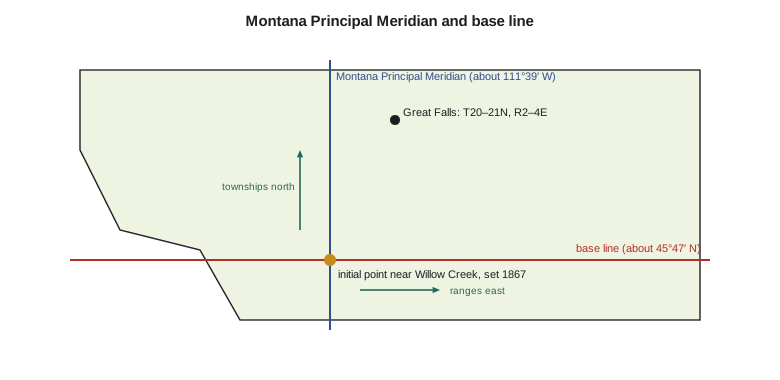
Each PLSS survey region begins at an initial point, through which a principal meridian runs north–south and a base line runs east–west. There are 37 principal meridians in the system. Montana's survey begins at an initial point on a limestone hill near Willow Creek, southwest of Three Forks, set in 1867; the Montana Principal Meridian runs north and south from it at about 111°39′ W, and the base line runs east and west at about 45°47′ N. Townships are counted north and south from the base line in tiers, and ranges east and west from the principal meridian. A township is identified by both, such as township 20 north, range 3 east, written T20N, R3E.
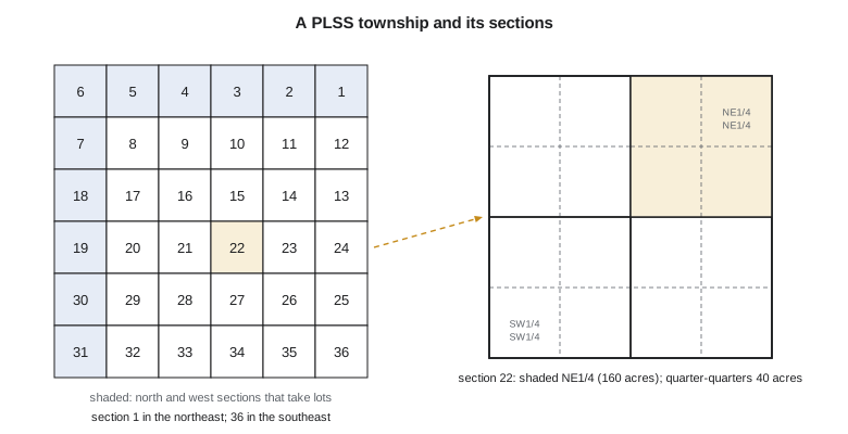
Each township is divided into 36 sections numbered from 1 in the northeast corner, running west along the top row to 6, then back east along the second row from 7 to 12, and so on in a back-and-forth pattern ending with section 36 in the southeast corner. Each section of about 640 acres can be divided into aliquot parts: quarters of 160 acres, quarter-quarters of 40 acres, and so on, described by compass direction, such as the NE1/4 NE1/4 of section 22. Where a section is irregular, because of convergence, water bodies or survey errors, the excess or deficiency is placed in fractional lots, usually along the north and west sides of the township, and these lots are given numbers and recorded areas.
Standard parallels and guide meridians
Meridians converge northward, so a township six miles wide at its south boundary is narrower at its north boundary. The PLSS controls this with standard parallels, also called correction lines, run east–west at intervals of 24 miles north of the base line, and guide meridians run north from the base line and each standard parallel at intervals of 24 miles east and west of the principal meridian. Each block of 16 townships bounded by these lines is surveyed from its south and east sides, so that the shortfall from convergence and the errors of measurement are thrown into the northern and western sections. Where a standard parallel is reached, new township and section lines start again at full width, which is why roads in Montana jog where they cross a correction line. Near Great Falls the convergence across one township is about 16 m, or about 52 ft.
import math
# Public Land Survey System township near Great Falls: the theory behind the grid
CHAIN = 20.1168                     # one Gunter's chain in meters (66 ft)
R = 6371000.0                       # mean Earth radius, m (good enough for this check)
sec_side = 80 * CHAIN               # a regular section is 80 chains (1 mile) on a side
print(f"section side {sec_side:.2f} m = {80*66} ft; area {sec_side**2/4046.8564224:.1f} acres")
print(f"quarter-quarter (aliquot 1/16) {sec_side**2/16/4046.8564224:.1f} acres")

# Sections are numbered back and forth, starting in the northeast corner
def section_number(row, col):        # row 0 = north tier, col 0 = west column
    return row * 6 + (6 - col if row % 2 == 0 else col + 1)
for row in range(6):
    print(" ".join(f"{section_number(row, c):2d}" for c in range(6)))

# Meridians converge: the north line of a township is shorter than its south line
base = 45 + 47 / 60 + 13 / 3600     # Montana base line latitude
lat_s = base + 19 * 6 * 80 * CHAIN / 111_200.0   # south line of T20N, ideal
lat_n = lat_s + 6 * 80 * CHAIN / 111_200.0
shrink = (math.cos(math.radians(lat_s)) - math.cos(math.radians(lat_n))) * 6 * 80 * CHAIN / math.cos(math.radians(lat_s))
print(f"T20N south line at about {lat_s:.4f} deg N; north line about {shrink:.1f} m ({shrink/0.3048:.0f} ft) shorter")

desc = "NE1/4 Sec. 22, T20N, R3E, M.P.M."
print(desc, "-> northeast quarter of section 22, township 20 north, range 3 east, Montana Principal Meridian")section side 1609.34 m = 5280 ft; area 640.0 acres quarter-quarter (aliquot 1/16) 40.0 acres 6 5 4 3 2 1 7 8 9 10 11 12 18 17 16 15 14 13 19 20 21 22 23 24 30 29 28 27 26 25 31 32 33 34 35 36 T20N south line at about 47.4368 deg N; north line about 15.9 m (52 ft) shorter NE1/4 Sec. 22, T20N, R3E, M.P.M. -> northeast quarter of section 22, township 20 north, range 3 east, Montana Principal Meridian
The code shows the numbers a surveyor keeps in mind: a regular section is 80 chains, or 5,280 ft, on a side and contains 640 acres; a quarter-quarter contains 40 acres; and sections are numbered from the northeast. It also shows that convergence alone makes a township near Great Falls about 52 ft narrower at its north line. Real townships rarely match the theory. The original surveyors worked with chains that stretched, solar compasses and terrain that made chaining hard, and some surveys were careless or even fraudulent. The lines as they ran them are the lines that count, a rule Lesson 3 explains.
Worked problem
Width shrinkage across a township
A township's south line is at latitude 47.4368° N and its north line is 9.656 km further north. Estimate how much shorter the north line is than the 9656 m south line, using a spherical Earth of radius 6371 km.
Show solution
- \[\Delta\varphi = 9656/111\,200 = 0.0868^\circ \quad\Rightarrow\quad \varphi_N = 47.5236^\circ\]
- \[\Delta L = 9656\,\Big(1 - \frac{\cos 47.5236^\circ}{\cos 47.4368^\circ}\Big) = 9656 \times 0.00165 = 15.9\ \text{m}\]
Answer: About 16 m, or 52 ft. The PLSS places this shortfall in the northern tier of sections of each township.
Corners and their monuments
Original PLSS surveyors marked township, section and quarter-section corners with the materials the instructions of the day required: wooden posts, stones, mounds of earth with pits, and bearing trees blazed and scribed so that a later surveyor could find the corner from the trees. Later surveys set iron pipes, and modern BLM surveys set brass or aluminum caps stamped with the corner's identity. Each kind of monument has a recorded description in the field notes, and knowing what the original surveyor was told to set, and where, is essential to recognizing it in the ground. Many states, including Montana, require that corner records be filed when a surveyor finds, restores or resets a PLSS corner, so that the next surveyor can follow the evidence.
The original plats and field notes of the PLSS are held by the BLM, and many are available online through the agency's General Land Office records. The plat shows the township as surveyed, with section lines, lots and their acreages; the field notes record what the surveyor saw and set along each line: distances to creeks, trails and changes in soil, and the bearing trees at each corner. Leah's research for every parcel in the district starts with the township plat and the field notes of the lines in question.
Protraction, resurveys and the BLM
Not every township was surveyed on the ground. In rugged or remote country, especially in the mountains west of Great Falls, many townships were protracted: the BLM drew their section lines on paper from the surveyed lines around them, without setting corners. Protracted descriptions are valid for leases and land management, but before land can be patented or its boundaries defended, the protracted lines must be surveyed. Where an original survey has been found grossly defective, or its corners largely lost, the BLM may carry out a resurvey. A dependent resurvey restores the original corners from the best available evidence and protects the rights of those who bought land by the original survey; an independent resurvey, used rarely and with care, creates new lines for land still held by the government while protecting the boundaries of patented parcels. The current rules for all of this are in the BLM's Manual of Surveying Instructions, published in 2009, which state and private surveyors also follow when they restore lost PLSS corners.
Lots, homesteads and later surveys
The PLSS was the framework for patents under the Homestead Act of 1862 and later land laws, which granted 160 acres and later larger units to settlers who lived on and improved the land. In the Sun River country, irrigation brought further surveys: the federal Reclamation Service, later the Bureau of Reclamation, surveyed canal rights of way across the sections and townsites at canal headquarters. A quarter section near Great Falls may carry the original PLSS survey, a railroad right of way, a Reclamation canal, a highway and a certificate of survey dividing a farmstead, each of which a retracement must respect.
| Unit | Nominal size | Described as | Retracement clue |
|---|---|---|---|
| Township | 6 × 6 miles, 36 sections | T20N, R3E, M.P.M. | Exterior lines surveyed first, often by a different contract |
| Section | 1 mile square, 640 acres | Sec. 22 | Corners at section and quarter positions |
| Aliquot part | 160, 40 acres and smaller | NE1/4 NE1/4 | Defined by protraction from corners |
| Government lot | Irregular | Lot 3 | Recorded acreage on the original plat |
| Mineral or homestead entry survey | Irregular | Survey No. | Own monuments, tied to the PLSS |
The lesson for the district project is simple to state and slow to apply: every parcel must be retraced in the system that created it. A Reclamation right-of-way plat from 1912 was laid out from the section corners as they stood in 1912, which may not be where the theory or a modern GIS puts them. Ines will retrace from the corners the original survey set, following the BLM's rules for restoring those that are lost.
Common mistakes
MistakeAssuming every section is exactly one mile square.
InsteadSections vary; the original corners, not the theory, define them.
MistakeNumbering sections from the southeast.
InsteadPLSS sections are numbered from 1 in the northeast corner.
MistakePlacing a quarter-quarter by assuming equal 40-acre parts in a fractional section.
InsteadCheck the original plat for lots and their acreages.
MistakeUsing a modern GIS grid in place of the original field notes.
InsteadRetrace from the original evidence, in the order the survey was made.
Summary and key terms
- The PLSS, created by the Land Ordinance of 1785, surveyed the public domain before sale into townships and sections.
- Each region has an initial point, a principal meridian and a base line; Montana's initial point dates from 1867.
- Townships are counted north or south of the base line and ranges east or west of the meridian.
- Sections are numbered from the northeast; aliquot parts and lots subdivide them.
- Standard parallels every 24 miles absorb convergence; roads jog where they cross them.
- Original corners and field notes, not the theoretical grid, govern where lines are.
- Public Land Survey System (PLSS)
- The rectangular survey of the US public domain into townships and sections.
- Initial point
- The origin of a PLSS region, where its principal meridian and base line cross.
- Township (PLSS)
- A block nominally six miles square containing 36 sections.
- Aliquot part
- A fractional part of a section described by direction, such as NE1/4.
- Government lot
- An irregular fractional part of a section with a recorded acreage.
- Standard parallel
- An east–west correction line where township lines restart at full width.
- Bearing tree
- A tree marked by the original surveyor to witness a corner.
Practice problems
Work each problem on paper first, then reveal the answer to check.
Describe the SW1/4 of Sec. 15, T21N, R2E, M.P.M. in words.
Show answer
The southwest quarter of section 15, township 21 north, range 2 east, Montana Principal Meridian.
Which section is in the southeast corner of a PLSS township?
Show answer
Section 36.
How many acres in a quarter-quarter section?
Show answer
About 40 acres.
Why do Montana roads jog at standard parallels?
Show answer
Township lines restart at full width there to correct for convergence.
Where do excess and deficiency usually fall in a PLSS township?
Show answer
In lots along the north and west sides.
Lesson quiz · 5 questions
Score 60% or more to complete this lesson.
Create a free account to save your progress, take quizzes and earn a certificate.