
GEOM-410 · Lesson 11 of 12 · 20 min
Licensing: state boards and NCEES FS and PS exams
Theo has worked at Coulee Geomatics for two years since finishing his geomatics degree. He runs computations, field crews and parts of the district project, but every plat and certificate of survey he prepares must be signed by Ruth, because only a licensed Professional Land Surveyor may establish property boundaries in Montana. This year he starts the last stage toward his license. This lesson explains how land surveyors are licensed in the United States, with the national examinations and Montana's requirements.
Why the profession is licensed
Boundary surveying is licensed because the public cannot easily judge it. A buyer cannot tell a sound retracement from a careless one, and the consequences of a bad one may not appear for decades. Every state therefore licenses land surveyors through a state board, which sets entry standards, issues licenses, adopts rules of professional conduct and standards of practice, investigates complaints and disciplines licensees. In Montana the board is the Board of Professional Engineers and Professional Land Surveyors, which licenses both professions and adopts the uniform standards for certificates of survey and subdivision plats.
Each state's license is valid only in that state. A surveyor who works in Montana and Idaho needs both licenses, and each state may require knowledge of its own laws and survey history, usually through a state-specific examination. The National Council of Examiners for Engineering and Surveying (NCEES), whose members are the state boards, develops the national examinations that every state uses, keeps records that help licensees move between states, and publishes a model law that many states follow in part.
The national examinations
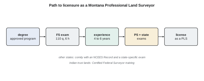
The path to licensure has two national examinations. The Fundamentals of Surveying (FS) exam is usually taken near the end of a degree or soon after; passing it, together with the state's requirements, qualifies a candidate as a surveyor in training. The Principles and Practice of Surveying (PS) exam is taken after several years of experience and tests the candidate's ability to practice competently. Both are computer-based and offered year-round at testing centers, closed book with an electronic reference handbook.
| Exam | Questions | Time | Knowledge areas |
|---|---|---|---|
| FS | 110 | 6 hours, including tutorial and break | Surveying processes and methods; mapping; boundary law and real property; surveying principles; computations and computer applications; business concepts; applied mathematics and statistics |
| PS | 100 | 7 hours, including tutorial and break | Legal principles; professional survey practices; standards and specifications; business practices; areas of practice |
The FS specification gives each knowledge area a range of questions rather than a fixed count. Boundary law and real property principles has the largest range, 19 to 29 questions, followed by survey computations and computer applications at 17 to 26, and surveying processes and methods at 16 to 24. The PS exam, in US customary units, puts the most weight on areas of practice, 24 to 36 questions, and professional survey practices, 22 to 33. Every state then adds its own state-specific examination on local law and practice.
Passing the FS early has practical advantages. The material is fresh near the end of a degree, the surveyor-in-training designation signals commitment to an employer, and the years of experience that follow can be planned around the PS exam. Theo passed the FS in his final semester and has spent his first two years at Coulee on field and computation work. Some candidates come into surveying from other fields, such as engineering, GIS or forestry, and take the FS after a degree in another discipline; Montana's education requirements mean that such candidates usually need additional surveying coursework, such as a minor in land surveying from an approved program, before they can qualify.
Montana's requirements
Montana's statute sets the qualifications. Every applicant must pass the FS exam. A graduate of a board-approved bachelor's program in land surveying then needs four years of office and field work under a licensed surveyor, with at least three years of progressive project experience. A graduate of a board-approved associate degree in land surveying, or of a bachelor's program with a minor in land surveying, needs six years, with at least four and a half years of progressive project experience. A route for applicants without a degree, requiring ten years of experience, was open only to applications made before October 1, 2022. With the experience and the board's references and project exhibits, the candidate is admitted to the PS exam and the Montana state-specific land surveyor examination; passing both leads to the license.
# Theo's study plan for the FS exam, weighted by the NCEES specification and his own weak areas
areas = {  # knowledge area: (min questions, max questions, self-rating 1 strong ... 5 weak)
    "Surveying processes and methods":          (16, 24, 2),
    "Mapping processes and methods":            (14, 21, 2),
    "Boundary law and real property principles": (19, 29, 5),
    "Surveying principles":                     (13, 20, 3),
    "Survey computations and computer applications": (17, 26, 2),
    "Business concepts":                        (11, 17, 4),
    "Applied mathematics and statistics":       (10, 15, 3),
}
total_hours = 240                          # about 20 hours a month for a year
weights = {a: (lo + hi) / 2 * r for a, (lo, hi, r) in areas.items()}
W = sum(weights.values())
mid = sum((lo + hi) / 2 for lo, hi, _ in areas.values())
print(f"midpoint of the ranges sums to {mid:.1f} of 110 questions")
for a, w in sorted(weights.items(), key=lambda x: -x[1]):
    lo, hi, r = areas[a]
print(f"{a:46s} {lo:2d}-{hi:2d} q rating {r} {total_hours * w / W:5.1f} h")midpoint of the ranges sums to 126.0 of 110 questions Boundary law and real property principles 19-29 q rating 5 75.6 h Business concepts 11-17 q rating 4 35.3 h Surveying principles 13-20 q rating 3 31.2 h Survey computations and computer applications 17-26 q rating 2 27.1 h Surveying processes and methods 16-24 q rating 2 25.2 h Applied mathematics and statistics 10-15 q rating 3 23.6 h Mapping processes and methods 14-21 q rating 2 22.0 h
Theo has 240 hours over the year. The plan weights each area by the midpoint of its question range times his self-rating, so boundary law, which is both the largest area and his weakest, gets about 76 hours, nearly a third of the total, while mapping, where he is strong, gets 22. The midpoints of the ranges add up to 126, more than the 110 questions on the exam, because the ranges overlap; the plan uses them only as relative weights. Ruth adds one thing the plan does not show: she will have him prepare, under her supervision, the retracement report for one complete district reach, because the PS exam and his later practice will ask him to defend exactly that kind of judgment.
Worked problem
Splitting study time
A candidate has 9 hours a week for two topics and rates herself 2 on one and 4 on the other, where higher means weaker. If both topics carry equal exam weight, how should she split her time?
Show solution
- \[\text{topic 1} = 9 \times \frac{2}{2+4} = 3\ \text{h}\]
- \[\text{topic 2} = 9 \times \frac{4}{2+4} = 6\ \text{h}\]
Answer: 3 hours and 6 hours a week. Weighting by weakness puts the effort where it is needed.
What the experience must teach
The years of supervised experience are not just time served. The board asks for references and project exhibits because it wants evidence that the candidate has done progressively responsible work: research of records and chains of title, retracement of PLSS corners under the BLM Manual, boundary decisions with documented evidence, certificates of survey and plats to Montana's uniform standards, and the filing of corner records. Ruth keeps a list for Theo of the kinds of work he must see and do before she will vouch for him: retracements in the PLSS and in at least one platted subdivision, a water boundary, a road right of way, an easement description, an ALTA/NSPS survey, and a full certificate of survey from research to filing.
Supervision is a responsibility for the supervising surveyor too. A licensed surveyor who signs a candidate's work, or provides a reference, is vouching for it. Ruth reviews Theo's research sketches and field decisions before they go into any certificate of survey, and she records her review, partly to protect the firm and partly because explaining her reasons is the best way to teach them.
Ethics and professional conduct
Licensure brings duties beyond technical competence. The board's rules of professional conduct require licensees to hold the public's safety, health and welfare first, to practice only in areas of competence, to sign and seal only work they prepared or directly supervised, to avoid and disclose conflicts of interest, to be objective and truthful in reports and testimony, and to report violations by others. A surveyor who seals a plat prepared by an unlicensed person without proper supervision, sometimes called plan stamping, risks discipline. For a candidate, this means the habits formed during the experience years, such as careful records, honest reporting and respect for other surveyors' evidence, become legal obligations on the day of licensure.
The PS exam itself reflects this. Its largest areas, professional survey practices and areas of practice, test whether a candidate can apply standards, plan surveys, evaluate evidence and handle the business and ethical situations of real practice, not just compute. Candidates prepare by working through cases with their supervisors, reviewing the BLM Manual and state law, and practicing the kind of written reasoning a certificate of survey or a report needs.
Licensure in other states
A licensed surveyor who wants to practice in another state applies for licensure by comity, also called endorsement. The new state checks that the applicant's education, experience and examinations meet its standards, often using the applicant's NCEES Record, which collects verified transcripts, experience, references and exam results in one place. Most states require their own state-specific examination even for experienced surveyors, because boundary law and survey history differ so much from state to state: a surveyor from a metes and bounds state needs to learn the PLSS and the BLM Manual before retracing in Montana. Firms offering surveying services usually need a business registration or certificate of authorization as well.
Montana's state-specific examination is where local knowledge is tested. Candidates should expect questions on Montana statutes about boundaries, water and easements, the subdivision laws and the certificate of survey exemptions, the uniform standards for plats, corner recordation, and how the PLSS was carried out in Montana, including the Montana Principal Meridian and the state's particular survey history. A surveyor licensed in another state who moves to Montana takes the same examination, which is one reason Ruth advises Theo to keep a notebook of every Montana-specific rule he meets on the district project.
Federal and continuing qualifications
For work on Indian trust lands, a state license is not enough on its own; as Lesson 9 described, the BLM's Certified Federal Surveyor program certifies state-licensed surveyors to work under federal standards. And after licensing, the learning continues. Many state boards require licensees to complete continuing professional development, reported each renewal period, and every licensee needs to keep up with changing standards, tools and law: the 2026 ALTA/NSPS standards, the new National Spatial Reference System and its datums, and Montana's 2023 Land Use Planning Act are recent examples. Theo plans to complete the Certified Federal Surveyor training once he is licensed, because the district's neighbors include tribal nations and federal land.
Common mistakes
MistakeSigning a certificate of survey before being licensed.
InsteadOnly a licensed Professional Land Surveyor may sign it; candidates work under supervision.
MistakeAssuming a Montana license allows practice in Idaho.
InsteadObtain a license in each state, usually by comity plus a state-specific exam.
MistakeStudying every FS area equally.
InsteadWeight study by the specification and by your own weaknesses.
MistakeAssuming a state license covers Indian trust land surveys.
InsteadTrust land surveys are made or approved under BLM authority; consider CFedS certification.
Summary and key terms
- Each state licenses land surveyors through a board; Montana's board licenses engineers and land surveyors.
- NCEES develops the FS (110 questions, 6 hours) and PS (100 questions, 7 hours) exams used by all states.
- Montana requires the FS, board-approved education and experience, the PS and a state-specific exam.
- Boundary law is the largest area of the FS specification.
- Licensure in other states is by comity, usually with a state-specific exam; NCEES Records simplify it.
- Federal certification and continuing development extend and maintain competence.
- Professional Land Surveyor (PLS)
- A surveyor licensed by a state board to establish property boundaries.
- NCEES
- The National Council of Examiners for Engineering and Surveying, which develops the national exams.
- FS exam
- The Fundamentals of Surveying exam, usually taken near the end of a degree.
- PS exam
- The Principles and Practice of Surveying exam, taken after experience.
- Surveyor in training (SIT)
- A candidate who has passed the FS exam and meets the state's requirements.
- Comity
- Licensure in another state based on an existing license.
- State-specific exam
- An exam on a state's own laws and survey practice.
Practice problems
Work each problem on paper first, then reveal the answer to check.
How many questions are on the FS exam, and how long is it?
Show answer
110 questions, 6 hours including tutorial and break.
Which FS knowledge area has the largest range of questions?
Show answer
Boundary law and real property principles, 19 to 29.
How many years of experience does Montana require after a bachelor's in land surveying?
Show answer
Four years, with at least three of progressive project experience.
Why do most states require a state-specific exam?
Show answer
Boundary law and survey history differ by state.
What is an NCEES Record used for?
Show answer
To collect verified credentials for licensure in other states.
Lesson quiz · 5 questions
Score 60% or more to complete this lesson.
Create a free account to save your progress, take quizzes and earn a certificate.