
GEOM-450 · Lesson 9 of 12 · 21 min
Plans of subdivision
Everything in the previous lessons leads to one document. The plan of subdivision is the legal instrument that turns a single parcel into hundreds of lots, dedicates the streets and parks to the public and records the easements that will govern the land for generations. It is prepared and certified by a licensed land surveyor, approved by the municipality, examined by the land titles office and, once registered, becomes the basis of every title, mortgage and building permit in the neighbourhood. Errors in it are expensive and hard to fix, because they become part of the legal record. This lesson covers what the document contains, how its geometry is checked and how it is approved, using the phase 1 plan of Coulee Ridge.
What the document does
In Alberta, a plan of subdivision is a plan of survey prepared under the Surveys Act and registered under the Land Titles Act. When it is registered, the Registrar cancels the existing certificate of title and issues new titles for each lot, with roads vesting in the Crown in right of Alberta, under the direction of the municipality, and reserve and public utility lots vesting in the municipality. Some subdivisions that create only a few large parcels can be done with a descriptive plan instead, which describes the new parcels without a full survey, but a residential subdivision like Coulee Ridge needs a surveyed plan with monuments on the ground.
The document has to serve three audiences at once. The land titles or recording office needs it to describe each new parcel unambiguously. Future surveyors need it to retrace every boundary from the monuments on the ground. And buyers, builders and the city need it to know what they own, where they can build and what rights others hold over their land.
Contents
The required contents are set by the Land Titles Act and its plan regulations, the Surveys Act and the Alberta Land Surveyors' Association's standards, but they are broadly similar everywhere. The drawing shows the boundary of the land being subdivided and every new parcel, with bearings and distances on every line and full curve data on every arc. It shows the monuments found and placed, their type and how they relate to the boundary. It shows the area of each lot and of each parcel being dedicated. It shows the streets with their names and widths, the easements and rights of way with their purposes, and any reserves or open spaces. And it carries the certificates and signatures that make it legal.
| Element | Plan of subdivision (Alberta) |
|---|---|
| Title and location | Plan title with the legal description of the land |
| Bearings | Basis of bearings and coordinate system stated |
| Parcels | Lots and blocks with dimensions and areas |
| Public land | Roads; reserve lots marked MR, SR, MSR or ER; public utility lots |
| Monuments | Statutory survey posts found and placed |
| Certificates | Surveyor's affidavit; endorsement by the subdivision authority |
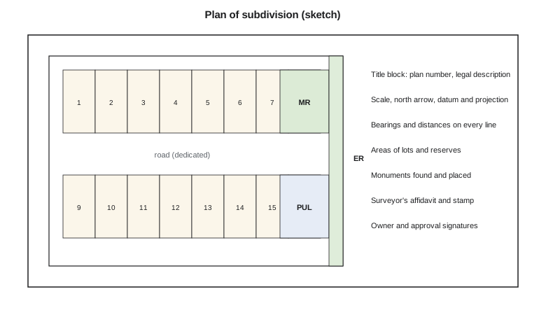
Geometry that closes
Every figure on the plan must close: the bearings and distances around each lot, each block and the whole boundary must return to the starting point. The plan dimensions are computed from the adjusted coordinates of the survey and of the design, so a correctly prepared plan closes to a few millimetres or hundredths of a foot around any figure, limited only by rounding. A larger misclosure means an error: a mistyped distance, a transposed bearing, a curve with the wrong radius. Checking closure figure by figure is therefore the first and most important quality check on the drawing.
Curved lines need special care. Each arc on the drawing carries its radius, arc length and central angle, and often its chord length and chord bearing, usually in a curve table. The values must be mutually consistent: the arc length must equal the radius times the central angle, and the chord must equal twice the radius times the sine of half the angle. A closure computation that uses the chord of each curve, rather than its arc, then checks the figure. Lots on the cul-de-sac bulb, with their short arcs and long radial sides, are where these checks most often catch a mistake.
Closure is also checked on the field survey that ties the plan to the ground. Grant's crew runs a traverse around the boundary of Block 3, measuring angles and distances between the found monuments. Theo's script computes the misclosure of the field traverse, adjusts it by the compass rule, which distributes the error in proportion to the length of each leg, and computes the area of the adjusted figure by coordinates.
import math
# Closure and area of the Block 3 boundary from the plan's bearings and distances
legs = [  # bearing (deg, min, sec) as an azimuth, distance (m)
    ((90, 0, 0), 186.420),
    ((180, 0, 12), 72.390),
    ((270, 0, 30), 186.405),
    ((0, 0, 0), 72.430),
]
E = N = 0.0; pts = [(0.0, 0.0)]; perim = 0.0
for (d, m, s), dist in legs:
    az = math.radians(d + m / 60 + s / 3600)
    E += dist * math.sin(az); N += dist * math.cos(az); perim += dist
    pts.append((E, N))
mis = math.hypot(E, N)
print(f"misclosure dE {E:+.3f} dN {N:+.3f} -> {mis:.3f} m, precision 1 in {perim / mis:,.0f}")
# Compass (Bowditch) adjustment, then area by coordinates
adj = []; run = 0.0
for k, ((d, m, s), dist) in enumerate(legs):
    run += dist
    x, y = pts[k + 1]
    adj.append((x - E * run / perim, y - N * run / perim))
area = 0.0
poly = [(0.0, 0.0)] + adj[:-1]
for (x1, y1), (x2, y2) in zip(poly, poly[1:] + poly[:1]):
    area += x1 * y2 - x2 * y1
area = abs(area) / 2
print(f"adjusted area {area:,.1f} m2 = {area / 10000:.4f} ha")misclosure dE +0.011 dN +0.067 -> 0.068 m, precision 1 in 7,615 adjusted area 13,498.1 m2 = 1.3498 ha
The traverse misses closure by 68 mm over a perimeter of about 518 m, a precision of about 1 in 7,600. The firm's own standard for urban boundary traverses is much tighter, so Ruth does not accept it. The size and direction of the error, almost all in the north component, point to the north-south legs; Grant checks his field notes and finds that the west leg was recorded as 72.430 m when the instrument recorded 72.363 m. With the correct distance the traverse closes within a few millimetres, and only then are the plan dimensions computed.
The compass rule is a simple adjustment suited to traverses with similar accuracy in angles and distances. Modern practice usually adjusts the whole survey network by least squares, which weights each observation by its precision and gives coordinates with stated uncertainties, as an earlier adjustment course showed. Whatever the method, the plan's dimensions come from the adjusted coordinates, not from the raw measurements.
Monuments
Monuments are the physical evidence of the plan on the ground. Alberta's Surveys Act requires survey posts to be placed at the corners of the new parcels, of a type set out in the regulations, with the plan showing each post found or placed. Because construction disturbs the ground, the exterior boundary and control monuments are placed first, and lot corner monuments are often placed after the roads and utilities are built, so that they are not destroyed by the work. The plan shows which monuments exist at the time of registration.
Future surveys rest on these monuments. When a homeowner wants a fence built or a lender wants a real property report years from now, the surveyor will start from the monuments on the plan. A missing or misplaced monument causes confusion for decades, which is why the placement and the record of each one deserve care.
Approval and examination
Before the plan can be registered, it must be endorsed by the subdivision authority, which checks that it matches the approved tentative plan and that the conditions of approval have been met or secured. The Land Titles Office then examines it for compliance with the plan regulations and survey standards and checks its consistency with the existing titles and plans. Only when both are satisfied is the plan registered and are the new titles issued. The endorsement must be followed by registration within the time the Act allows, or the approval lapses.
Worked problem
Area of a lot with a corner cut
Corner lot 1, Block 1, is a rectangle 15.0 m wide and 33.5 m deep, with a 3.0 m by 3.0 m corner cut at the intersection taken as road. What area is shown on the plan?
Show solution
- \[A_\text{rect} = 15.0 \times 33.5 = 502.5 \text{ m}^2\]
- \[A_\text{cut} = \tfrac{1}{2} \times 3.0 \times 3.0 = 4.5 \text{ m}^2\]
- \[A = 502.5 - 4.5 = 498.0 \text{ m}^2\]
Answer: 498.0 m², or 0.0498 ha.
Easements, covenants and other documents
The plan rarely travels alone. Easements and rights of way for utilities, drainage swales, the walkway storm sewer and the pipeline crossing are granted by separate documents registered against the new titles at the same time as the plan, each with a sketch or description that matches the drawing exactly. Restrictive covenants record the limits that the approvals require, such as the basement and irrigation restrictions on the coulee lots, the lot grading plan and the architectural controls the developer wants. A caveat may protect the city's interest under the servicing agreement until the works are accepted.
These documents are where many errors hide, because they are prepared by different people at different times from the drawing. The surveyor's job is to make sure that every strip shown on the plan is described in a document, that every document refers to a strip that exists on the drawing, and that the widths, lot numbers and plan references agree. A swale easement described as 3 m wide on a lot where the drawing shows 2 m is the kind of mismatch that ends in a dispute between neighbours years later.
Names, addresses and digital submission
Street names must be approved by the city, which checks them against existing names to avoid duplicates and confusion for emergency services. House numbers are assigned by the city's addressing staff from the lot layout, so the plan and the addressing map must use the same lot and block numbers. Increasingly, cities and land titles offices also ask for a digital version of the subdivision: lot lines and dimensions in a CAD or GIS format on the stated coordinate system, so that the parcel fabric can be updated directly rather than redrawn. Theo exports the phase 1 parcels from the design model with their attributes, checks that every polygon closes and that their areas match the drawing to the last digit, and includes the file with the submission.
Phasing, remainders and future plans
Because Coulee Ridge is built in phases, the phase 1 plan creates the lots of phase 1 and leaves the rest of the land as a remainder parcel. Its boundary must be described as carefully as any lot, because the phase 2 plan will start from it. Roads that will continue into later phases end at the phase boundary with a temporary turnaround, protected by an easement over the remainder. Utility easements over the remainder protect the trunk mains that run through it. The control network and the boundary monuments are designed once for the whole project, so that each phase ties seamlessly to the last.
Coulee Geomatics: the phase 1 submission
The phase 1 plan has 118 lots in four blocks, the park, the pond lot, the walkways and the roads. Before it goes to the city, it is checked by a second surveyor in the firm who did not prepare it. She recomputes every closure and every area, compares the drawing with the approved tentative plan and with the engineering drawings, checks every street name with the city's addressing staff and reads every certificate. Her checklist finds nine small errors, among them a lot area off by 2 m², a missing curve radius and an easement shown on the drawing but not described in the accompanying documents. Each is fixed before submission. Independent checking of this kind, before the document leaves the office, is the cheapest quality control a surveyor can buy.
Common mistakes
MistakeAccepting a field traverse because it nearly closes.
InsteadCompare its precision with the standard and find the cause of any large misclosure.
MistakeComputing plan dimensions from raw field measurements.
InsteadCompute them from adjusted coordinates so that every figure closes.
MistakePlacing every lot corner monument before construction.
InsteadPlace boundary and control monuments first; place lot corners after the works, as the rules allow.
MistakeLetting the person who drew the plan be its only checker.
InsteadHave an independent surveyor recompute closures, areas and certificates.
Summary and key terms
- A registered plan of subdivision creates new titles and vests roads and reserves.
- The document shows boundaries, dimensions, curve data, areas, monuments, public land, easements and certificates.
- Every figure must close; plan dimensions come from adjusted coordinates.
- Field traverses are checked against a precision standard, and errors are traced before acceptance.
- Monuments are the evidence future surveys rely on; boundary monuments go first, lot corners often after construction.
- Endorsement by the subdivision authority and examination at Land Titles precede registration.
- Plan of subdivision
- A plan of survey that, when registered, divides land into new parcels with new titles.
- Descriptive plan
- A plan describing new parcels without a full survey, used for some simple subdivisions.
- Survey post
- A statutory monument marking a parcel corner.
- Endorsement
- The subdivision authority's confirmation that a plan conforms to its approval.
- Misclosure
- The distance by which a traverse or figure fails to return to its starting point.
- Compass rule
- An adjustment that distributes misclosure in proportion to leg length.
Practice problems
Work each problem on paper first, then reveal the answer to check.
Why should computed plan dimensions close almost perfectly?
Show answer
They come from adjusted coordinates, so only rounding remains; larger errors indicate mistakes.
What does a misclosure mostly in the north component suggest?
Show answer
An error in the north-south legs, such as a mistyped distance.
Why are lot corner monuments often placed after construction?
Show answer
Road and utility work would disturb or destroy them.
What happens to a remainder parcel in a phased subdivision?
Show answer
It is described on the plan and later subdivided in its own phase.
Who should check the plan before submission?
Show answer
An independent surveyor who did not prepare it.
What is the area of a 12.0 by 33.5 lot with no corner cut, in the same units squared?
Show answer
402.0.
Lesson quiz · 5 questions
Score 60% or more to complete this lesson.
Create a free account to save your progress, take quizzes and earn a certificate.