
GEOM-450 · Lesson 2 of 12 · 21 min
Planning law and approvals
Land cannot be divided simply because an owner wants to sell it in pieces. Every state and province controls the creation of new parcels, because subdivision commits a community to roads, pipes, schools and services for generations. The rules set out who decides, what plans must be in place first, what the applicant must provide, what the approving body must consider and what land or money the developer must give to the public in return. This lesson walks through those rules in Alberta as Coulee Ridge moves from concept to approval.
Why subdivision is regulated
Before modern planning law, land was often divided into lots with no roads, no water and no drainage, and the cost of fixing these fell on later owners and the public. Speculative plats were drawn on paper far beyond any real demand, leaving scattered lots that could not be serviced efficiently. Subdivision control grew out of these problems. Its purposes are to make sure that new lots are suitable for their use, that they can be served with roads and utilities at reasonable public cost, that development fits the community's plans, and that the new parcels are described precisely enough to be registered and insured.
The planning framework in Alberta
In Alberta, planning and subdivision are governed by the Municipal Government Act, Part 17, together with the Subdivision and Development Regulation and provincial land use policies. The Act sets up a hierarchy of plans. A municipal development plan sets the long-range policy for the whole city: where growth will go, how dense it will be and how it will be serviced. For a new neighbourhood, council usually adopts an area structure plan that fixes the road network, land uses, school and park sites, servicing concepts and phasing for a larger area. Below the plans sits the land use bylaw, which divides the city into districts and sets the permitted and discretionary uses, lot sizes, setbacks and building heights in each.
The key idea is conformity. A subdivision application must be consistent with the statutory plans and the land use bylaw. If the land is still zoned for agriculture, as Coulee Ridge is, the developer must first apply to council to redistrict it, and if no area structure plan covers it, one must be prepared and adopted. These are political decisions made by council after a public hearing, and they often take longer than the subdivision itself.
Zoning standards that shape the lots
Zoning sets the dimensions within which lots must be designed. For single-detached housing the main controls are minimum lot width, often called frontage, minimum lot depth, minimum lot area, front, side and rear setbacks, maximum site coverage and building height. Corner lots usually need extra width because the side yard facing the flanking street has a larger setback. Lots on curves and cul-de-sacs are usually measured at the front setback line, where the house will sit, rather than at the curved property line, which can be much shorter.
| District rule (course values) | Low-density residential |
|---|---|
| Minimum interior frontage | 12.0 m |
| Minimum corner frontage | 13.5 m |
| Minimum depth | 30.0 m |
| Minimum area | 360 m² |
| Front setback | 6.0 m |
| Side setbacks | 1.2 m each side |
These values are typical of single-detached districts in prairie cities but are course values, not quotations from any bylaw. The point is the method: every draft lot is checked against every rule before the plan goes to the city. Theo writes a short script to do this for the lots Leah has drafted, and adds a check of the reserve dedication described below.
# Check draft lots against the low-density district rules used in this course
MIN_FRONT, MIN_FRONT_CORNER, MIN_AREA, MIN_DEPTH = 12.0, 13.5, 360.0, 30.0   # m, m, m2, m
lots = [  # name, frontage at the front setback line (m), depth (m), area (m2), corner?
    ("B1-1", 15.0, 33.5, 502, True),
    ("B1-2", 13.4, 33.5, 449, False),
    ("B1-9", 12.2, 33.5, 409, False),
    ("B2-1", 12.8, 33.5, 429, True),
    ("B3-4", 10.9, 36.0, 512, False),   # pie lot on the cul-de-sac bulb
    ("B3-7", 13.0, 27.5, 357, False),   # shallow lot at the coulee edge
]
for name, f, d, a, corner in lots:
    need = MIN_FRONT_CORNER if corner else MIN_FRONT
    problems = []
    if f < need: problems.append(f"frontage {f} < {need}")
    if a < MIN_AREA: problems.append(f"area {a} < {MIN_AREA:.0f}")
    if d < MIN_DEPTH: problems.append(f"depth {d} < {MIN_DEPTH}")
    print(f"{name:5} {'corner' if corner else 'interior':8} {'OK' if not problems else '; '.join(problems)}")

# Reserve owing: 10 % of the land being subdivided, less environmental reserve
gross, er = 24.6, 2.9
owing = 0.10 * (gross - er)
provided = 1.62 + 0.38          # neighbourhood park + linear park beside the coulee
short = owing - provided
print(f"reserve owing {owing:.2f} ha, land provided {provided:.2f} ha")
if short > 0:
    rate = 210000               # appraised value per hectare, illustrative
print(f"shortfall {short:.2f} ha, money in place of land about {short * rate:,.0f} dollars")B1-1 corner OK B1-2 interior OK B1-9 interior OK B2-1 corner frontage 12.8 < 13.5 B3-4 interior frontage 10.9 < 12.0 B3-7 interior area 357 < 360; depth 27.5 < 30.0 reserve owing 2.17 ha, land provided 2.00 ha shortfall 0.17 ha, money in place of land about 35,700 dollars
Three of the six lots fail. The second corner lot is too narrow for its flanking side yard, the pie lot on the cul-de-sac is too narrow at the setback line, and the shallow lot at the coulee edge fails both area and depth. Each failure has a different fix: widen the corner lot by taking width from its neighbour, move the front setback line deeper on the pie lot so it is measured where the lot is wider, and merge the shallow lot with the one beside it. Running the checks on every lot each time the layout changes catches problems long before the city's reviewer does.
Reserves and dedications
The Municipal Government Act allows the subdivision authority to require land for public purposes. Environmental reserve may be taken for land that is unsuitable for development, such as a swamp, gully, ravine, coulee or natural drainage course, land subject to flooding or that is unstable, and a strip along the bank of a water body. It stays in its natural state or is used as a public park. The owner may instead be required to register an environmental reserve easement that leaves the land in private hands but protects it.
Municipal reserve, school reserve or a combination may also be required, up to 10 percent of the land being subdivided after environmental reserve is deducted. The authority may take land, money in place of land based on the land's market value, or a mix. Land is usually taken where it is needed for a park or school site, and money where a small subdivision would give only a useless sliver. The Act also allows an additional amount in higher-density subdivisions. Reserve land is transferred to the municipality on the plan of subdivision and shown with the designation MR, SR or MSR.
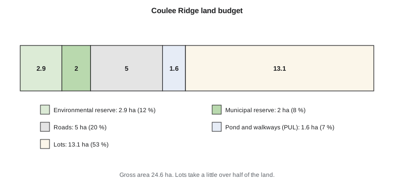
At Coulee Ridge, the coulee slope and a setback strip at the top of bank, 2.9 ha in all, qualify as environmental reserve. Municipal reserve owing is 10 percent of the remaining 21.7 ha, or 2.17 ha. The concept provides a 1.62 ha neighbourhood park and a 0.38 ha linear park, 2.00 ha in total, so about 0.17 ha is owed as money in place of land, which Theo's script estimates at about 36,000 dollars using an illustrative appraised value.
The application and its review
A complete subdivision application in Alberta typically includes the tentative plan showing the proposed lots, roads, reserves and utility lots; the certificate of title and any encumbrances; the applicant's authorization; and supporting studies the authority asks for, such as geotechnical, environmental, traffic and servicing reports. The Subdivision and Development Regulation lists matters the authority must consider, including the topography, soil, drainage, servicing, the use of land nearby and required setbacks from things such as wastewater plants, landfills and sour gas facilities. The application is referred to agencies including school boards, utility companies and provincial departments where provincial interests are involved, such as highways or water bodies.
The subdivision authority must make a decision within a time limit set in the Act, unless the applicant agrees to extend it. The decision may be an approval with conditions, which is usual, or a refusal. Conditions typically require a servicing or development agreement, payment of off-site levies, provision of reserves, registration of easements and restrictive covenants, and a lot grading plan. Appeals go to the subdivision and development appeal board or, in specified cases such as provincial interests, to the Land and Property Rights Tribunal.
Rights and interests already on the land
Planning approval is not the only permission a subdivision needs. The title search at the start of the project shows the interests already registered against the land, and each one shapes the layout. At Coulee Ridge the list includes a right of way for a high-pressure gas pipeline across the north edge, a utility right of way for an overhead power line along the south road, and the irrigation district's right of way for a lateral canal, with the district's rights to deliver water to the farms beyond it. The pipeline operator sets rules for crossings, setbacks and ground disturbance, and must consent to any road or utility that crosses its right of way. The irrigation district must agree to any change to its lateral, and in practice the lateral will be piped where it passes through the new neighbourhood.
Other approvals sit with provincial agencies. Work near the coulee may need approval under the Water Act for any change to a natural drainage course, and a clearance under the Historical Resources Act if the land has heritage potential. Each of these has its own timeline, and each condition is listed in Ruth's tracking sheet so that none is forgotten at the end, when the plan is ready and only a missing consent stands in the way.
Off-site costs
New development draws on infrastructure outside its boundary: arterial roads, trunk sewers, reservoirs, treatment plants. Alberta municipalities may charge off-site levies by bylaw to pay for new or expanded facilities that serve the development, calculated by a published method and usually charged per hectare at subdivision approval. The levy is a significant cost; lesson 11 includes it in the Coulee Ridge estimate.
Worked problem
Reserve owing on a small subdivision
A 9.6 ha parcel includes 1.1 ha of ravine taken as environmental reserve. The authority requires municipal reserve at the maximum rate and accepts land for 0.55 ha of a park, with money for the rest at 190,000 dollars per hectare. How much money is owed?
Show solution
- \[\text{MR} = 0.10 \times (9.6 - 1.1) = 0.85 \text{ ha}\]
- \[\text{shortfall} = 0.85 - 0.55 = 0.30 \text{ ha}\]
- \[\text{money} = 0.30 \times 190\,000 = 57\,000 \text{ dollars}\]
Answer: 57,000 dollars in place of 0.30 ha.
Coulee Geomatics: the approvals path
Claire's pre-application notes set out the path for Coulee Ridge: an area structure plan amendment to bring the land into the neighbourhood plan, redistricting from agricultural to residential districts, then the subdivision application for phase 1 with the full set of studies. She asks for a geotechnical setback line at the coulee before the reserve boundary is fixed, and for a traffic study of the new collector's connection to the arterial road. Ruth builds the schedule backward from Dana's target sales date and finds that the planning amendments, not the subdivision, are the critical path.
Common mistakes
MistakeSubmitting a subdivision for land whose zoning does not allow the proposed lots.
InsteadConfirm the plans and zoning first; amend them before applying.
MistakeMeasuring the frontage of a cul-de-sac lot along its curved front line.
InsteadMeasure where the bylaw says, usually at the front setback line.
MistakeCalculating municipal reserve on the gross area.
InsteadDeduct environmental reserve first; reserve is a share of the remaining land.
MistakeTreating conditions of approval as a formality.
InsteadConditions are binding; the plan cannot be registered or filed until they are met.
Summary and key terms
- Subdivision control ensures that new lots are usable, serviceable, consistent with plans and precisely described.
- In Alberta, the Municipal Government Act sets up statutory plans, land use bylaws and subdivision approval.
- Zoning sets lot frontage, depth, area and setbacks, which every lot must be checked against.
- Environmental reserve protects unsuitable land; municipal and school reserve take up to 10 percent of the rest as land or money.
- Approvals come with conditions on agreements, levies or fees, easements and technical approvals.
- Planning amendments are often the longest step in the schedule.
- Municipal development plan
- A statutory plan setting long-range land use and growth policy for a municipality.
- Area structure plan
- A statutory plan for a new area fixing land uses, roads, servicing and phasing.
- Land use bylaw
- The bylaw dividing a municipality into districts with permitted uses and development rules.
- Environmental reserve
- Land unsuitable for development dedicated to the municipality, such as a coulee or flood-prone land.
- Municipal reserve
- Land or money provided for parks, schools and recreation, up to 10 percent of the developable land.
- Off-site levy
- A charge for new or expanded infrastructure outside a development that serves it.
Practice problems
Work each problem on paper first, then reveal the answer to check.
Why must zoning be in place before the subdivision application?
Show answer
The lots must conform to the zoning; without it the approving body cannot approve them.
Where is the frontage of a pie lot usually measured?
Show answer
At the front setback line, not along the curved front property line.
What land can be taken as environmental reserve?
Show answer
Land such as a swamp, gully, ravine, coulee, natural drainage course, flood-prone or unstable land, and a strip along a water body.
What is a typical condition of subdivision approval?
Show answer
A servicing agreement with the city and payment of off-site levies.
A corner lot is 12.8 wide where the corner rule asks for 13.5 (same units). Name a fix.
Show answer
Take width from the neighbouring interior lot if it stays above its own minimum, or reduce the number of lots on the face.
Why did the Coulee Ridge schedule depend most on the planning stage?
Show answer
Plan amendments and zoning are political decisions with public hearings that often take longer than subdivision review.
Lesson quiz · 5 questions
Score 60% or more to complete this lesson.
Create a free account to save your progress, take quizzes and earn a certificate.