
GEOM-450 · Lesson 6 of 12 · 21 min
Grading
Grading is the shaping of the ground surface so that a subdivision drains, its streets and lots fit together, and every house sits at a sensible elevation. It is where the road profiles of lesson 5, the drainage concept of lesson 7 and the sewer depths of lesson 8 meet the lots of lesson 4. Bad grading shows up for decades as wet basements, icy driveways, water flowing from one yard into the next and arguments between neighbours. Good grading is invisible: water simply goes where it should. This lesson covers the principles, the lot grading types, the computations for lot elevations and the overall earthwork of Coulee Ridge.
Goals of grading
Grading has five goals, roughly in order of importance. Water must flow away from every building. Water from each lot must reach the street, a swale or a pond without crossing a neighbouring lot in a way that harms it. Major storm flows must have a safe overland route through the neighbourhood, usually along the streets, so that when pipes are overwhelmed water does not enter houses. Streets, driveways and walks must have grades that are safe and accessible. And the earthwork should balance, so that soil does not have to be hauled to or from the site at great cost.
These goals conflict. A steep fall away from a house is good for drainage but makes a steep driveway; a balanced earthwork might leave a low lot that cannot drain. The designer works through the conflicts by setting a grading plan for the whole neighbourhood first, then fitting each lot into it.
Lot grading types
Most residential lots fall into three types. A back-to-front lot drains entirely to the street: the rear yard is higher than the front, and water flows along the sides of the house and out to the gutter. A split-drainage lot has a high point at the house: the front yard drains to the street and the rear yard drains to a swale along the rear lot line, shared with the lot behind. A front-to-back lot drains entirely to the rear, toward a lane, a swale or an open space. The type is chosen for each lot from the street profile and the natural slope, and it is shown on the lot grading plan.
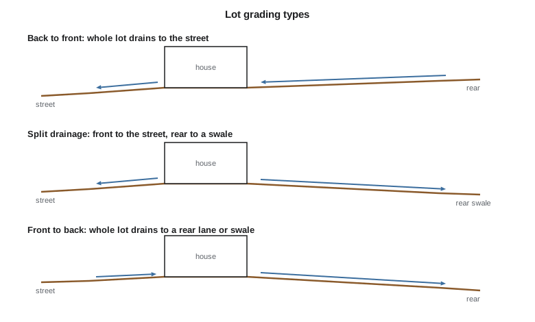
On land that falls gently away from the street, as on the east side of the collector at Coulee Ridge, split drainage or front-to-back lots fit naturally. On land that rises from the street, back-to-front lots fit. A rear-lot swale must have somewhere to go: it is graded to a side-yard swale between two houses or to a walkway, and from there to the street or the pond. Swales running behind many lots are usually protected by an easement so that fences and sheds do not block them.
Slopes that make grading work
A small set of slopes controls most lot grading. Around the foundation, the ground must fall steeply for the first few metres so that roof and surface water moves away quickly. Municipal lot grading standards in Alberta commonly ask for a steep fall near the foundation; this course uses 10 percent over the first 2 m, then at least 2 percent across the rest of the yard. Grassed swales need at least about 1 percent, preferably more, or they stay wet. Side slopes of berms and banks are kept to about 3 horizontal to 1 vertical or flatter so they can be mowed and do not erode; steeper changes need retaining walls.
| Element | Course value | Reason |
|---|---|---|
| Fall away from the foundation | 10 % over the first 2 m | Moves water away quickly |
| Yard surfaces | 2 % minimum | Grass drains without ponding |
| Grassed swales | 1 % minimum, 1.5 % preferred | Avoids wet, soft swales |
| Driveways | 2 % to about 8 % | Drainage and winter safety |
| Landscaped slopes | 3:1 or flatter | Mowing and erosion |
Setting lot elevations
The lot grading plan gives, for each lot, the elevations at the property corners, the design grade at the house, the swale elevations and the drainage arrows. The design grade at the house sets the top of foundation, usually a fixed height above grade, and so the basement floor elevation, which must sit above the sewer service and preferably above the seasonal groundwater. The front of the lot is tied to the street: the top of curb comes from the road profile, and the boulevard and sidewalk rise from the curb at a set cross slope to the property line.
Theo's script works through one back-to-front lot and one split-drainage lot on Coulee Ridge Drive, starting from the top of curb and building the elevations back across the lot.
# Lot grading: back-to-front lots and a split-drainage lot (elevations in m)
curb_front = 906.42          # top of curb at the middle of the lot
blvd = 0.16                # boulevard and sidewalk fall toward the curb (rise from curb)
lot_depth = 33.5
house_front, house_depth = 6.0, 14.0     # front setback and house depth
fall_house = 0.20          # fall away from the foundation over the first part of the yard
fall_dist = 2.0
yard_slope = 0.02            # minimum slope across the rest of the lot
# back-to-front: the whole lot drains to the street
prop_front = curb_front + blvd
house_front_grade = prop_front + yard_slope * house_front
grade_at_house = house_front_grade + fall_house       # ground at the foundation
rear_wall = grade_at_house
rear_lot = rear_wall + yard_slope * (lot_depth - house_front - house_depth)
print("back-to-front lot:")
print(f"  property line {prop_front:.2f}, ground at front wall {grade_at_house:.2f}, rear corner {rear_lot:.2f}")
# split drainage: front half to the street, rear half to a rear-lot swale
swale_start, swale_end, swale_len = 907.05, 906.48, 54.0
s = (swale_start - swale_end) / swale_len
print("split-drainage rear swale:")
print(f"  slope {100 * s:.2f} %  ({'OK' if s >= 0.01 else 'too flat'}, minimum {100 * 0.01:.1f} %)")
rear_split = swale_start + fall_house
print(f"  ground at rear wall needs to be at least {rear_split:.2f}")
# simple foundation fall check
print(f"fall away from the foundation: {fall_house:.2f} over {fall_dist} = {100 * fall_house / fall_dist:.1f} %")back-to-front lot: property line 906.58, ground at front wall 906.90, rear corner 907.17 split-drainage rear swale: slope 1.06 % (OK, minimum 1.0 %) ground at rear wall needs to be at least 907.25 fall away from the foundation: 0.20 over 2.0 = 10.0 %
For the back-to-front lot, the property line sits 0.16 m above the curb, the yard rises at 2 percent to the house, and the ground at the front wall is set 0.20 m higher still to give the required fall away from the foundation. The rear corner, rising at 2 percent from the back of the house, ends at 907.17. For the split-drainage lot, the rear swale behind the block falls from 907.05 to 906.48 over 54 m, a slope of just over 1 percent, which meets the minimum but leaves little margin. Sunil asks for the swale to be split into two lengths draining to the walkways at each end, which raises its slope to about 2 percent.
Grade transitions and retaining walls
Where the design grade on one lot is much higher than on its neighbour, the difference must be taken up somewhere. A gentle landscaped slope within a side yard or along a rear lot line is the cheapest answer, at 3 horizontal to 1 vertical or flatter. Where there is no room for a slope, a retaining wall is needed. Walls over a certain height usually require engineering design and a building permit, and walls on lot lines raise questions of who owns and maintains them. Good neighbourhood grading avoids walls between lots wherever possible, by stepping street profiles and choosing lot types so that adjoining lots are at similar elevations.
Grading at the coulee edge
The first row of lots along the trail at Coulee Ridge needs special care. The geotechnical report forbids fill within the setback strip and asks that no water be directed toward the bank. These lots are therefore graded back-to-front or split to a swale that runs parallel to the bank and discharges to the walkways, and the rear yards slope gently toward that swale, away from the trail. Roof leaders must discharge to the front. The restriction is written into the lot grading plan and the restrictive covenant so that later owners cannot quietly regrade their yards toward the coulee.
Overland flow and the major system
Pipes are sized for frequent storms, but rare storms exceed them. When that happens, water flows on the surface, and the grading must give it a safe path. Streets are the main overland routes: their profiles must carry water to the pond or another safe outlet without trapping it in a sag where houses are low. At any sag that cannot drain overland, the houses around it must be set high enough above the ponding level, and an emergency overflow route must be graded between houses or through a walkway. The designer traces each overland route on the grading plan and checks the depth of water in the street against the city's limits.
At Coulee Ridge the collector carries overland flow east to the pond, and two walkways carry flow from the cul-de-sacs, whose bulbs are low points, to the trail and down to the pond. The lowest house openings around each bulb are set at least 0.3 m above the ponding level in a rare storm. Lesson 7 sizes the pond for that storm.
Earthwork
Grading the whole site means moving soil. The topsoil is stripped first and stockpiled for reuse on lots and boulevards. The subsoil is then cut where the design is below the existing ground and filled where it is above, with the volumes computed by comparing the design surface to the existing terrain model, as an earlier surveying course showed. Fill is placed in layers and compacted, and lots built on deep fill may need engineered fill with testing. Trench spoil from pipes and basement excavations adds more soil later, so designers usually aim for a slight surplus of cut on the overall grading to allow for it, or for fill if the basements will produce a lot of spoil.
At Coulee Ridge the first design had too much fill in the low southeast corner. Lowering two local streets by about 0.2 m and steepening their grades from 1.5 to 2 percent brought the cut and fill within a few percent of each other, saving an estimated 20,000 m³ of imported fill. Grant's crew will later survey the stripped surface and the finished grades so that the quantities can be paid and the lots certified.
Worked problem
Elevations along a lot
A back-to-front lot is 33.5 m deep. The property line at the front is at 905.80. The front setback is 6.0 m, the house is 14.0 m deep, the yard slopes at 2 percent and the ground falls 0.20 m over the first 2 m away from the foundation. Find the ground elevation at the front wall and at the rear corner.
Show solution
- \[\text{at the setback line: } 905.80 + 0.02 \times 6.0 = 905.92\]
- \[\text{at the front wall: } 905.92 + 0.20 = 906.12\]
- \[\text{rear corner: } 906.12 + 0.02 \times (33.5 - 6.0 - 14.0) = 906.39\]
Answer: 906.12 at the front wall and 906.39 at the rear corner.
Certifying the grading
Grading plans mean little unless they are built. Many Alberta municipalities require a rough grade certificate after the house is framed and backfilled and a final grade certificate after landscaping, each prepared by a land surveyor or engineer, comparing surveyed elevations with the approved lot grading plan. Grant's crew will survey hundreds of these at Coulee Ridge over the build-out, and the tolerance, usually a few centimetres or a tenth of a foot, decides whether a builder's deposit is returned.
Common mistakes
MistakeSetting the house grade from the natural ground alone.
InsteadSet it from the street profile, the lot type and the required falls, then check sewer and groundwater.
MistakeDraining a rear swale onto the next block.
InsteadCarry swales to side-yard swales, walkways or the street within an easement.
MistakeIgnoring where water goes when the pipes are full.
InsteadTrace overland routes and set openings above ponding levels at sags.
MistakeBalancing earthwork on the design surface without allowing for trench and basement spoil.
InsteadPlan a deliberate surplus or deficit that accounts for spoil.
Summary and key terms
- Grading moves water away from buildings, carries it to safe outlets and fits streets, lots and houses together.
- Lots are back-to-front, split-drainage or front-to-back, chosen from the street profile and natural slope.
- Steep falls near foundations, 2 percent yards and at least 1 percent swales are typical working values.
- Lot elevations are built back from the top of curb through the boulevard, setback and house.
- Major storm flows need overland routes, usually the streets, with houses set above ponding levels.
- Earthwork should nearly balance, allowing for topsoil, compaction and later spoil.
- Lot grading plan
- A plan showing design elevations, drainage types and swales for every lot.
- Split drainage
- A lot that drains from a high point at the house to both the street and the rear.
- Swale
- A shallow grassed channel that carries surface water.
- Major system
- The overland flow routes that carry storms exceeding pipe capacity.
- Top of foundation
- The elevation of the top of the foundation wall, set from the design grade.
- Grade certificate
- A surveyed check that a lot was graded as approved.
Practice problems
Work each problem on paper first, then reveal the answer to check.
Why might a split-drainage lot suit land that falls away from the street?
Show answer
The rear yard can follow the natural fall to a rear swale while the front drains to the street.
What happens if a swale is too flat?
Show answer
It stays wet, grass dies and water may pond against houses.
Where does overland flow go when the storm sewer is full?
Show answer
Along the streets and graded routes to the pond or another safe outlet.
Why are houses around a cul-de-sac bulb often set higher?
Show answer
The bulb may be a low point where water ponds in a rare storm.
Why is topsoil stripped and stockpiled?
Show answer
It is reused for lawns and boulevards and is unsuitable as structural fill.
What does a grade certificate compare?
Show answer
Surveyed elevations with the approved lot grading plan.
Lesson quiz · 5 questions
Score 60% or more to complete this lesson.
Create a free account to save your progress, take quizzes and earn a certificate.