
GEOM-450 · Lesson 4 of 12 · 22 min
Lot layout
With the site understood and the rules known, the design of the neighbourhood itself can begin. Lot layout is where planning, engineering and market judgement meet on one drawing. The street pattern decides how people move and how pipes run; the block shape decides how many lots fit and how efficient the roads are; the lot dimensions decide what houses can be built and what they will sell for. This lesson works through the layout of Coulee Ridge from the street pattern down to individual lots, and shows the computations a surveyor uses to make every dimension work.
Street patterns
The street pattern is the skeleton of a subdivision. A grid of straight streets and rectangular blocks is efficient, easy to navigate and gives many route choices; it suits flat land and is the historical pattern of most prairie cities. A curvilinear pattern of loops and bays follows the contours, slows traffic and creates quieter streets, but can confuse visitors and lengthen walking trips. Cul-de-sacs give the quietest streets and are popular with buyers, but they reduce connectivity, push traffic onto collectors and make walking and transit less convenient.
Modern practice usually blends these. A modified grid keeps short, connected blocks but bends streets to fit the land; cul-de-sacs are kept short and linked by walkways so that pedestrians can pass through even where cars cannot. Many cities now set maximum block lengths, often a few hundred metres, and minimum connectivity measures such as the number of intersections per square kilometre, to keep neighbourhoods walkable. At Coulee Ridge the collector follows the gentle ridge from the west entrance, local streets run roughly north and south across the slope so that their gutters can drain toward the collector and the pond, and two short cul-de-sacs reach toward the coulee to give view lots, each with a walkway to the trail.
Blocks
A block is the land bounded by streets. Its depth is usually two lot depths back to back, sometimes with a lane or a utility strip between them. Its length is set by the street spacing and by walkability standards. Long blocks reduce the number of intersections and the length of road per lot, so they are cheaper, but they make walking trips longer. Very short blocks are walkable but road-hungry. A useful efficiency measure is the length of road frontage needed per lot: with lots on both sides of a street, each metre of street serves two metres of frontage.
Block ends matter. The lots at the ends of a block are corner lots, which need extra width, and the end of each block wastes some land where the side yard faces the flanking street. Blocks that end on a curve or at an angle create irregular lots that are harder to sell and to build on. Experienced designers try to place the irregular geometry in parks, walkways and utility lots rather than in house lots.
Lot types and dimensions
The lot dimension follows from the house type the market wants. Front-drive single-detached houses with attached garages need wider lots, typically 12 to 15 m or more, because the garage takes much of the front. Laned lots, where garages face a rear lane, can be narrower, often 9 to 11 m, with the street front left to porches and trees. Semi-detached and townhouse lots are narrower again. Depth is usually 30 to 36 m for single-detached lots. Mixing types in one neighbourhood helps reach density targets and broadens the market.
Lot orientation also counts. Lots with the long side running north and south get good winter sun on the main living spaces and suit rooftop solar. View lots along the coulee command a premium, which is why the developer wants as many as the setback line allows. Lots backing onto arterial roads need deeper rear yards or noise walls. Through lots, with frontage on two streets, are usually avoided because both frontages need treatment and neither is clearly the front.
| Lot type | Typical frontage | Notes |
|---|---|---|
| Single-detached, front drive | 12 to 15 m | Garage dominates the front; wide lot |
| Single-detached, laned | 9 to 11 m | Garage at the rear; needs a lane |
| Semi-detached, per unit | 7.5 to 9 m | Shared wall on the lot line |
| Townhouse, per unit | 6 to 7.5 m | Rear lane or shared parking |
| Pie lot on a cul-de-sac | 9 m at the curb | Wide at the rear; measured at the setback |
Dividing a block face
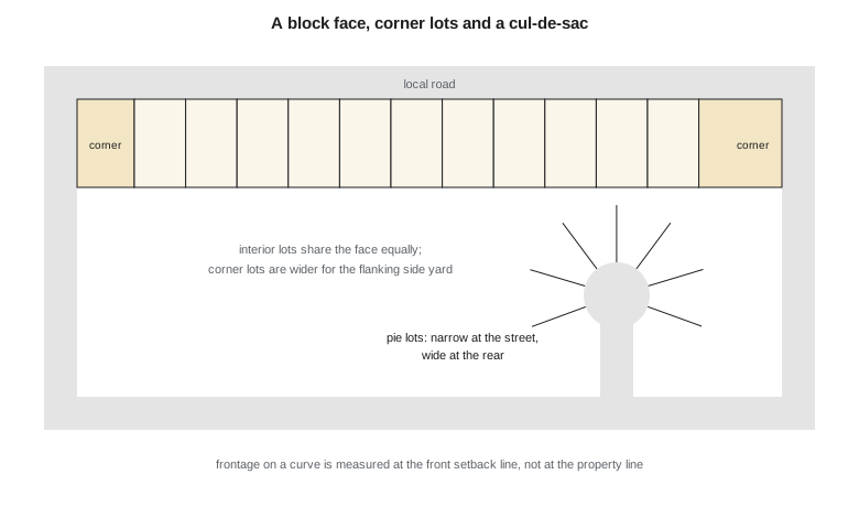
Once a block is drawn, its face is divided into lots. The usual approach is to set the corner lots first, wider by the extra side yard, and then divide the rest equally among interior lots that meet the minimum and come as close as possible to the target width. Equal interior lots keep the plan simple and the construction staking efficient. If the remainder does not divide neatly, the designer chooses between slightly wider lots and one more lot at the minimum width, which is a business decision as much as a design one.
Theo's script below divides a 242 m block face along the collector with a target interior frontage of 13.4 m and then checks the area of a pie lot on the cul-de-sac by the coordinate method.
# Divide a block face into lots, then check an irregular lot by coordinates
face = 242.0            # length of the block face between street lines (m)
corner_extra = 1.5      # corner lots are wider for the flanking side yard
typical = 13.4          # target interior frontage (m)
minimum = 12.0          # district minimum interior frontage
n = int((face - 2 * corner_extra) // typical)
while True:
    interior = (face - 2 * corner_extra) / n
    if interior >= minimum and interior < typical + 0.5 * typical:
        break
    n -= 1
corner = interior + corner_extra
print(f"{n} lots on a {face} m face: 2 corner lots of {corner:.2f} m, interior lots of {interior:.2f} m")
n2 = int((face - 2 * corner_extra) // minimum)
print(f"at the district minimum the face would hold {n2} lots of {(face - 2 * corner_extra) / n2:.2f} m")

def area(pts):           # shoelace formula
    s = 0.0
    for (x1, y1), (x2, y2) in zip(pts, pts[1:] + pts[:1]):
        s += x1 * y2 - x2 * y1
    return abs(s) / 2
pie = [(0.0, 0.0), (9.4, -2.1), (25.8, 31.6), (-5.6, 35.2)]              # pie-shaped lot on the bulb, corners in local coordinates (m)
a = area(pie)
print(f"pie lot area {a:.1f} m2")17 lots on a 242.0 m face: 2 corner lots of 15.56 m, interior lots of 14.06 m at the district minimum the face would hold 19 lots of 12.58 m pie lot area 718.2 m2
At the target width the face holds 17 lots, with interior lots a little wider than the target. If all interior lots were cut to the district minimum, two more lots would fit. Dana asks the question every developer asks: are two extra lots worth narrower houses on the whole block? For this view-side block, Ruth recommends the wider lots, because buyers here will pay for frontage, and suggests putting narrow-lot product near the park in phase 2 where it can help with the density target.
Lots on curves and cul-de-sacs
On a curved street, lot lines are usually drawn radial to the curve, so that each lot is a wedge. The front property line is an arc, and the frontage measured along it is shorter on the inside of a curve than on the outside. Because a house sits behind the front setback, bylaws usually measure the frontage of such lots at the setback line, where the arc has a larger radius. The surveyor computes this frontage from the central angle of the lot: the arc length at any radius is the radius times the angle in radians.
Cul-de-sac bulbs give the most extreme wedges. The bulb's property line arc is short, so the lots are narrow at the street and wide at the rear. Their frontage at the setback line, their area and their buildable envelope must each be checked. The shoelace formula used in the script gives the area of any lot from the coordinates of its corners, and the same coordinates feed the plan of subdivision in lesson 9.
Worked problem
Frontage at the setback line of a pie lot
A pie lot on a bulb of radius 17.0 m has a 9.0 m arc along its front property line. The front setback is 6.0 m. What is its frontage at the setback line, and does it meet a 12.0 m minimum?
Show solution
- \[\theta = \frac{9.0}{17.0} = 0.529 \text{ rad}\]
- \[f = \theta \,(17.0 + 6.0) = 0.529 \times 23.0 = 12.2 \text{ m}\]
Answer: About 12.2 m, which meets the 12.0 m minimum.
From sketch to dimensioned layout
A concept layout is a sketch; a subdivision plan is a set of exact dimensions. Leah builds the layout in the design software as a geometric model: street centrelines with tangents and curves, right-of-way lines offset from them, block boundaries, and lot lines defined by frontage and direction. Every lot is then a closed figure whose corners have coordinates, so its dimensions, area and closure can be computed. Changes are made to the model, not to individual lines, so that a widened street or a moved curve updates every affected lot.
The dimensioned layout is checked against the rules from lesson 2, against the servicing concept from Brightwater and against the grading. Sunil's first comments are typical: one local street is too flat to drain and needs to move a few metres uphill; two lots sit over the trunk sewer and must become a walkway; the pond lot needs more room for maintenance access. Each change costs a lot or two, and the yield drops from the first estimate of about 265 lots to 254 in the plan that goes to the city.
Density and housing mix
A layout of identical front-drive lots rarely meets a modern density target, and it narrows the market to one kind of buyer. Mixing lot types is the usual answer. A few blocks of laned lots near the park, a row of semi-detached lots along the collector and a townhouse site at the entrance can lift the density of a neighbourhood by a quarter or more without changing its character. Each type needs its own geometry: lanes need their own right of way, usually 6 to 8 m wide, with utility poles or pedestals placed so that garbage trucks and plows can pass; townhouse sites are usually left as larger parcels for a builder to subdivide later, often as a condominium.
At Coulee Ridge the mix also helps the business case. Dana's sales advisers tell her that the view lots will sell slowly but at a premium, and that narrower lots near the park will sell quickly to first-time buyers. Ruth's team therefore keeps the coulee-side blocks at 14 m or more and puts 10 m laned lots and two townhouse sites in phase 2. The final plan has 252 single-detached and semi-detached lots and two townhouse sites, 254 residential parcels designed for about 310 homes, which brings the density close to 14 units per net hectare, much nearer the city's expectation.
Utility lots, walkways and easements
Not every parcel on the plan is a house lot. Public utility lots hold the stormwater pond, a lift station if one is needed, and walkways that link cul-de-sacs to the trail. Each needs enough width for its purpose and for maintenance vehicles: a walkway that also carries a storm sewer may need 6 m or more, not the 3 m a path alone would need. Where a pipe or overland drainage route must cross private lots, an easement or right of way is registered over a strip of each lot instead, and the strip is shown on the plan. The designer tries to keep such strips at the rear of lots and as short as possible, because buyers dislike them and they constrain fences, sheds and landscaping.
Coulee Geomatics: the layout review
Before the layout goes in, Ruth runs a review meeting with the whole team. They walk through the plan street by street, asking the same questions each time: does every lot meet the rules, does every lot drain, can every lot be serviced from the street, is every walkway useful, and is there any lot that a buyer would struggle to build on? Three lots are adjusted after the meeting, and the layout is frozen for the application.
Common mistakes
MistakeDividing the face equally among all lots, including the corners.
InsteadSet the wider corner lots first and divide the remainder among interior lots.
MistakeMeasuring cul-de-sac frontage along the curved front line.
InsteadMeasure at the front setback line, where the house will be.
MistakePutting awkward geometry into house lots.
InsteadPush irregular remnants into parks, walkways and utility lots.
MistakeEditing individual lot lines when the street geometry changes.
InsteadEdit the geometric model so that all lots update consistently.
Summary and key terms
- The street pattern sets connectivity, traffic, drainage and servicing; modern layouts blend grids with short cul-de-sacs and walkways.
- Block length balances road cost against walkability; block ends create corner lots.
- Lot widths follow the house type: front-drive lots are wider than laned or attached lots.
- Corner lots are set first; interior lots share the rest of the face as equally as possible.
- Frontage on curves is measured at the setback line using arc length equals radius times angle.
- A dimensioned geometric model lets every lot be checked for rules, area and closure.
- Block face
- The length of one side of a block along a street.
- Corner lot
- A lot at the intersection of two streets, with a flanking side yard.
- Pie lot
- A wedge-shaped lot on a curve or cul-de-sac bulb.
- Through lot
- A lot with frontage on two streets, usually avoided.
- Laned lot
- A lot served by a rear lane, allowing a narrower street frontage.
- Shoelace formula
- A formula giving the area of a polygon from the coordinates of its vertices.
Practice problems
Work each problem on paper first, then reveal the answer to check.
Why are cul-de-sacs often linked by walkways?
Show answer
To keep pedestrian connectivity while limiting through traffic.
Why do long blocks lower servicing cost?
Show answer
Fewer intersections and less road length are needed per lot.
What is the advantage of laned lots?
Show answer
Garages move to the rear, so lots can be narrower and the street front is greener.
Why are lot lines usually radial on a curved street?
Show answer
Radial lines give regular wedge-shaped lots with right angles to the street.
How does a change to street geometry propagate in a good layout model?
Show answer
The lots are defined from the street geometry, so they update automatically.
Why did the Coulee Ridge yield fall from the first estimate?
Show answer
Engineering review moved a street, turned lots over the trunk sewer into a walkway and enlarged the pond lot.
Lesson quiz · 5 questions
Score 60% or more to complete this lesson.
Create a free account to save your progress, take quizzes and earn a certificate.