
GEOM-450 · Lesson 1 of 12 · 22 min
The development process
A quarter section of dry cropland on the edge of a city looks simple from the road. It is flat, it has a view of the coulee, and a highway runs past it. Turning it into a neighbourhood of a few hundred homes takes years of work by planners, engineers, surveyors, lawyers, lenders and council, and a geomatics engineer sits close to the centre of that work. The surveyor defines the land at the start, measures the ground the designers rely on, lays out the lots and roads, stakes them for construction and, at the end, prepares the plan that creates the new parcels in law. This course follows one project from first sketch to registered plan and uses it to teach the design and approval skills that land development needs.
The project is Coulee Ridge, a 24.6 ha parcel on the west edge of Lethbridge, Alberta, where the prairie breaks into a steep coulee above the river. Prairie Hearth Communities, a regional developer, has an option to buy the land. Its development manager, Dana Whitford, has asked Coulee Geomatics for a feasibility study before she commits. Ruth Albrecht, the firm's principal and a licensed land surveyor, will run the job with Leah Tran on design and GIS, Theo Martel on computations and code, and Grant Okonkwo leading the field crew. Sunil Mehta of Brightwater Engineering will design the roads and pipes, and Claire Fontaine, the city's subdivision planner, will review everything that comes in.
What land development is
Land development is the process of converting land from one use to another, here from agriculture to housing, and of creating the legal parcels, public roads, utilities and open space that the new use needs. It joins three kinds of work. The planning work decides what may be built and where, through the city's plans and zoning. The engineering work designs how the land will drain, how traffic will move and how water, sewer and power will reach each lot. The legal and survey work creates new titles that can be sold, mortgaged and insured.
Each kind of work constrains the others. A road layout that looks efficient on paper may need a sewer too deep to build. A lot pattern that meets the zoning may leave a pond with nowhere to drain. A grading plan that balances cut and fill may push water onto a neighbour. Good subdivision design is the search for a layout that satisfies all of these at once and still makes money, and that search is the subject of this course.
The people involved
The developer owns or controls the land, takes the financial risk and makes the final business decisions. Lenders finance the work and watch the budget and the sales pace. The municipality approves the plans, takes over the roads, pipes and parks when they are finished, and maintains them for decades, so its standards are written with long-term cost in mind. Utility companies for power, gas and telecommunications design their own networks in coordination with the engineer.
The consultants carry out the design. Planners prepare the concept and the planning applications. Civil engineers design grading, roads, stormwater, water and sewer. Geotechnical engineers advise on soils, slope stability and groundwater, which matter a great deal beside a coulee. Environmental consultants assess wetlands, wildlife and contamination. Landscape architects design parks and streetscapes. The land surveyor provides the base survey, the legal boundaries, the plan of subdivision and the construction staking, and is often the first consultant on site and the last to leave.
| Role | Main concern | Typical deliverable |
|---|---|---|
| Developer | Profit, risk and timing | Pro forma, decisions on phasing and product |
| Municipal planner | Conformity with plans and bylaws | Review comments, conditions of approval |
| Civil engineer | Grading, drainage, roads and pipes | Servicing design drawings and reports |
| Geotechnical engineer | Soils, slopes, groundwater | Geotechnical report, setback recommendation |
| Land surveyor | Boundaries, topography, legal parcels | Base plan, plan of subdivision, staking |
| Utility companies | Power, gas, communications | Utility layouts and servicing agreements |
The stages of a project
Every jurisdiction has its own procedure, but the sequence is broadly similar. It starts with due diligence: title searches, a review of planning documents, a look at existing services and a first estimate of how many lots the land might yield. If the numbers work, the land is bought or optioned and the planning stage begins. In Alberta, a new neighbourhood usually needs an area structure plan adopted by council and a land use bylaw amendment before subdivision. A pre-application meeting with the city follows, where the planner explains what the application must include.
The subdivision application itself is supported by a tentative layout, technical studies and an engineering concept. After review, the approving authority approves it with conditions, refuses it or asks for changes. The conditions are then met: a development or servicing agreement is signed with the city, securities are posted and the roads and pipes are built. Finally the surveyor prepares the plan of subdivision, which is endorsed by the municipality and registered at the Land Titles Office, and the new lots legally exist.
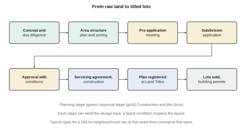
The timeline is long. A neighbourhood of a few hundred lots may take two to five years from concept to first sales, and longer if planning documents must be amended or a market downturn intervenes. Most of the developer's money is spent before any lot is sold, which is why the financial analysis in lesson 11 and lesson 12 matters so much.
Phasing
Large subdivisions are built in phases so that the developer does not have to finance all the roads and pipes at once. Each phase must work on its own: it needs a complete road connection, a sewer outlet, a water loop that meets fire flow, and drainage to a pond that is already built or temporary. The order of phases is usually set by the trunk services. At Coulee Ridge the sanitary sewer leaves the site at the west boundary, so phase 1 starts there and later phases march east toward the coulee.
Phasing affects the surveyor directly. Each phase gets its own plan of subdivision, its own construction staking and its own set of monuments. Remainder parcels between phases must be described clearly, and the overall boundary and control network must be designed so that later phases fit the earlier ones without gaps or overlaps.
The surveyor's work across the project
It helps to list the survey tasks in order, because they recur in almost every lesson. At the start come the title search and the boundary survey, which confirm what land the developer is actually buying and what rights of way and caveats or easements cross it. Next is the topographic survey, combining GNSS and total station work with an airborne lidar terrain model, on a control network that will serve the whole project. During design the surveyor checks the layout geometry, computes lot dimensions and areas and confirms that the plan will close. During construction the crew stakes the roads, pipes and lots, measures quantities for progress payments and records as-built locations. At the end the surveyor places the legal monuments and prepares and certifies the plan of subdivision. No other consultant touches the project so often.
Gross and net areas
Not all of the land becomes lots. A first estimate of yield starts from the gross area and subtracts land that cannot be built on, which gives the net developable area. In Alberta, land such as a coulee slope or a watercourse margin is typically taken as environmental reserve, and the municipal reserve dedication is calculated on the remainder. From the net area come the dedications for parks, the roads, the stormwater pond and walkways. What is left is divided into lots.
Road area depends on the street pattern and lot depth, but for a typical suburban layout local roads take about a fifth to a quarter of the net area. Lots are never perfectly regular, because of corners, curves and the edges of the site, so a layout loss of several percent is subtracted before dividing by the typical lot size. Theo's script below produces the first estimate that Dana will use to decide whether the land is worth buying.
# Coulee Ridge: first gross-to-net yield estimate (areas in hectares)
gross = 24.6           # titled area being subdivided
er = 2.9               # coulee slope and top-of-bank setback, environmental reserve
net = gross - er       # net developable area, the base for municipal reserve
mr = 0.10 * net        # municipal reserve at the 10 percent maximum
pond = 1.45            # stormwater pond, a public utility lot
walk = 0.15            # walkways and utility corridors
roads = 0.23 * net     # local roads at about 23 percent of net area
lots_area = net - mr - pond - walk - roads
lot = 13.4 * 33.5 / 10000          # typical lot, 13.4 m x 33.5 m, in hectares
layout_loss = 0.08                 # corner, curve and odd-shaped lots
n_lots = int(lots_area * (1 - layout_loss) / lot)
print(f"net developable area      {net:6.2f} ha")
print(f"municipal reserve (10 %)  {mr:6.2f} ha")
print(f"roads                     {roads:6.2f} ha")
print(f"area left for lots        {lots_area:6.2f} ha ({lots_area / gross:.0%} of gross)")
print(f"typical lot               {lot * 10000:6.0f} m2")
print(f"estimated lots            {n_lots:6d}")
print(f"density                   {n_lots / net:6.1f} units per net ha")
for target in (17, 22):
print(f"lots needed for {target} u/ha {round(target * net):6d}")net developable area 21.70 ha municipal reserve (10 %) 2.17 ha roads 4.99 ha area left for lots 12.94 ha (53% of gross) typical lot 449 m2 estimated lots 265 density 12.2 units per net ha lots needed for 17 u/ha 369 lots needed for 22 u/ha 477
The estimate gives about 265 lots on 21.7 ha of net developable area, or 12.2 units per net hectare. Roughly half of the gross area ends up in lots, which is normal for a suburban subdivision with a large natural area. Claire tells Ruth that the city's planning documents for new neighbourhoods expect higher densities than a single-detached layout gives; the course uses 17 units per net hectare as an illustrative target, which would need about 370 units. Meeting that would mean adding townhouses or narrower lots, a question the layout work in lesson 4 returns to.
Worked problem
A quick yield check
A 16.0 ha parcel has 1.2 ha of environmental reserve. Municipal reserve is 10 percent of the net area, roads are 24 percent of the net area and a pond takes 0.8 ha. Lots average 420 m², with a 7 percent layout loss. Estimate the number of lots.
Show solution
- \[A_\text{net} = 16.0 - 1.2 = 14.8 \text{ ha}\]
- \[A_\text{lots} = 14.8 - 1.48 - 0.24(14.8) - 0.8 = 8.97 \text{ ha}\]
- \[n = \frac{8.97 \times 10\,000 \times 0.93}{420} = 198.6\]
Answer: About 198 lots, or 13.4 units per net hectare.
Constraints and opportunities
Before any layout is drawn, the team lists what the land offers and what it forbids. At Coulee Ridge the opportunities are the view, the trail potential along the top of bank and a gentle slope toward the west that suits gravity drainage. The constraints are the coulee itself, where slopes exceed 15 percent and slope stability is a concern, an existing gas pipeline right of way crossing the north edge, a gravel road on the south boundary that will need upgrading, and the irrigation district's lateral, whose right of way and drainage rights must be respected. Lesson 3 turns this list into maps.
A good feasibility study also flags the unknowns. Ruth's list includes the depth to groundwater near the coulee, whether the city's trunk sewer has capacity, and whether the provincial archaeology database records any sites. Each unknown carries a risk to cost or schedule, and the developer needs to know about them before buying.
Coulee Geomatics: the feasibility memo
Ruth's memo to Dana sets out the yield estimate, the land budget, a first look at the approvals path and a list of studies needed: a topographic survey and lidar-based terrain model, a geotechnical report on the coulee setback, a biophysical assessment of the slopes, a servicing study by Brightwater and a traffic impact assessment. It estimates that the first lots could be sold about two and a half years after the land is bought. Dana takes the memo to her board, which approves the purchase, and the work of the following lessons begins.
Common mistakes
MistakeEstimating yield by dividing gross area by lot size.
InsteadSubtract reserves, roads, ponds and layout losses first; lots are usually about half of the gross area.
MistakeDesigning the layout before checking where the sewer can drain.
InsteadFind the servicing outlets first; they set phasing and often the street pattern.
MistakeTreating each phase as a fragment of the final plan.
InsteadEach phase must stand alone with roads, water, sewer and drainage.
MistakeLeaving the surveyor out until the plan must be registered.
InsteadBring the surveyor in at the start; boundaries, topography and title issues shape the design.
Summary and key terms
- Land development converts land to a new use and creates the parcels, roads, utilities and open space it needs.
- Planning, engineering and legal survey work constrain one another, and design must satisfy all three.
- Projects pass through due diligence, planning approval, subdivision approval, construction and registration of the plan.
- Phasing spreads cost over time, but each phase must function independently.
- Yield estimates move from gross area to net area to lot area, with allowances for roads and layout losses.
- The geomatics engineer is involved from the base survey at the start to the final plan and staking at the end.
- Gross area
- The total area of the parcel being developed.
- Net developable area
- The gross area less land that cannot be developed, such as steep slopes and watercourses.
- Yield
- The number of lots or dwelling units a site can produce.
- Phasing
- Building a development in stages, each with its own services and plan.
- Density
- Dwelling units per unit of area, usually net area.
- Due diligence
- Investigation of title, planning, servicing and site conditions before buying land.
Practice problems
Work each problem on paper first, then reveal the answer to check.
Why is road area expressed as a share of net area rather than gross area?
Show answer
Roads serve only the developable land; slopes and reserves left natural need no roads.
What sets the order of phases most often?
Show answer
The trunk services, especially the sanitary sewer outlet and the water connection.
Name three studies a subdivision beside a coulee will need.
Show answer
A geotechnical slope study, a biophysical or environmental assessment and a stormwater or servicing study.
What is the layout loss in a yield estimate?
Show answer
An allowance for corner, curved and irregular lots that make the actual lot area larger than the typical lot.
Why does the developer care so much about the timeline?
Show answer
Most costs are paid before sales begin, so delay increases financing cost and risk.
Which plan creates the new parcels in law?
Show answer
The plan of subdivision registered at the Land Titles Office.
Lesson quiz · 5 questions
Score 60% or more to complete this lesson.
Create a free account to save your progress, take quizzes and earn a certificate.