
GEOM-450 · Lesson 3 of 12 · 21 min
Site analysis
A subdivision design is only as good as the understanding of the land beneath it. Site analysis is the systematic study of a parcel's physical, environmental, legal and human characteristics before any lot is drawn. Its product is a set of maps and a short report that say where development is easy, where it is costly and where it should not happen at all. For a geomatics engineer this is familiar ground: the data come from surveys, lidar, imagery and public databases, and they are combined in a GIS exactly as in earlier courses. What is new is the purpose. Every layer is read for what it means for lots, roads, pipes and drainage.
The base survey
Site analysis starts with a reliable base. Grant's crew establishes a control network of six monuments around Coulee Ridge, tied to the provincial integrated survey network and to the city's control. They survey the boundary, recover existing monuments and locate fences, roads, power poles, the pipeline markers and the irrigation lateral. Ines processes a recent airborne lidar flight into a bare-earth terrain model on a 1 m grid, checked against 45 ground check points that Grant surveys with RTK GNSS on open, flat ground. The vertical accuracy, reported as an RMSE, is about 4 cm, good enough for planning and preliminary grading but not for final pipe design, which will rely on detailed ground surveys along the alignments.
The base plan shows the legal boundary, the registered rights of way and easements, the existing features, contours at 0.5 m intervals and spot elevations at key points such as the low corners and the top of the coulee bank. It is the drawing every other consultant will design on, so its datum, units, projection and accuracy are stated in its title block.
Slope and landform
Slope is the single most important physical factor in residential layout. Very flat land, below about 1 to 2 percent, is hard to drain: water sits in yards and gutters, and sewers have to be deep to get enough fall. Gentle slopes of 2 to 5 percent are ideal; roads, lots and pipes all fit without much grading. Slopes of 5 to 10 percent are workable but need more careful grading and may suit walkout basements. Slopes of 10 to 15 percent are expensive to build on and limit road grades. Above about 15 percent, building is usually avoided, both for cost and because steep slopes in soft sediments may be unstable.
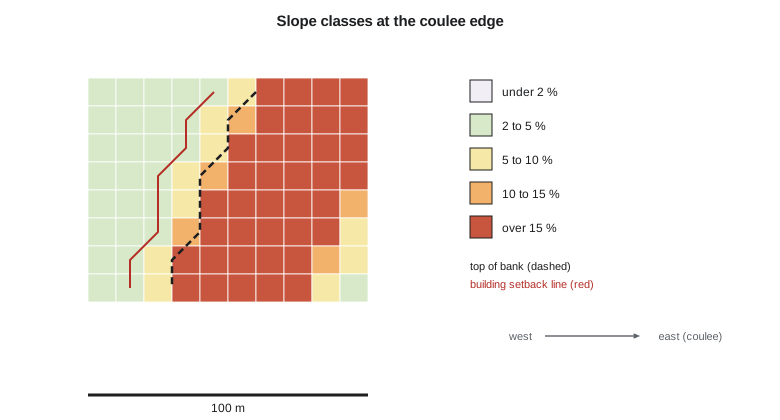
Slope is computed from the terrain model as the magnitude of the elevation gradient, using differences between neighbouring cells. The result is classified into ranges that match these design thresholds. Theo's script below does this for a small grid near the coulee edge and finds the top of bank, the line where the land steepens beyond 15 percent.
# Slope classes from a small elevation grid near the coulee edge
import math
CELL = 10.0                          # grid spacing (m)
rows, cols = 10, 12
def z(r, c):                           # a plateau that breaks into the coulee on the east
    x = c * CELL; y = r * CELL
    base = 912.0 - 0.035 * x - 0.010 * y
    drop = 28.0 / (1 + math.exp(-(x - 95.0 + 0.45 * y) / 6.0))   # the coulee edge bends
    return base - drop
Z = [[z(r, c) for c in range(cols)] for r in range(rows)]
classes = [(2, "under 2 %: too flat, drainage hard"), (5, "2-5 %: ideal for lots and roads"),
           (10, "5-10 %: workable with grading"), (15, "10-15 %: costly, walkout lots"),
           (1e9, "over 15 %: steep, avoid building")]
count = [0] * len(classes)
for r in range(1, rows - 1):
    for c in range(1, cols - 1):
        dzdx = (Z[r][c + 1] - Z[r][c - 1]) / (2 * CELL)
        dzdy = (Z[r + 1][c] - Z[r - 1][c]) / (2 * CELL)
        s = 100 * math.hypot(dzdx, dzdy)
        k = next(i for i, (lim, _) in enumerate(classes) if s < lim)
        count[k] += 1
tot = sum(count)
for (lim, name), n in zip(classes, count):
    print(f"{name:38} {n:3d} cells  {100 * n / tot:5.1f} %")
# top of bank: first cell in each row where the slope steepens past 15 %
tob = []
for r in range(1, rows - 1):
    for c in range(1, cols - 1):
        if 100 * (Z[r][c] - Z[r][c + 1]) / CELL > 15:
            tob.append(c * CELL); break
print(f"top of bank from the west line: {min(tob):.0f} to {max(tob):.0f} m")
print(f"building line with a {15} m setback: {min(tob) - 15:.0f} m from the west line")under 2 %: too flat, drainage hard 0 cells 0.0 % 2-5 %: ideal for lots and roads 27 cells 33.8 % 5-10 %: workable with grading 10 cells 12.5 % 10-15 %: costly, walkout lots 5 cells 6.2 % over 15 %: steep, avoid building 38 cells 47.5 % top of bank from the west line: 40 to 70 m building line with a 15 m setback: 25 m from the west line
About a third of this sample is in the ideal 2 to 5 percent class, and nearly half is steeper than 15 percent: the cells east of the bank, where the land drops toward the coulee floor. The top of bank wanders across the sample because the coulee edge bends. A straight building line drawn 15 m west of the farthest-west point of the bank would be simple to administer, but it would waste land where the bank swings east. In practice the setback line follows the bank, offset by the distance the geotechnical engineer recommends.
Soils, geology and groundwater
The coulees of the Oldman valley are cut into glacial and post-glacial deposits: clay till, silts and sands, with lake clays in places. These soils can be stable on gentle slopes but may slump on steep ones, especially when wetted by leaking pipes, irrigation or poor drainage. The geotechnical engineer drills boreholes, installs standpipes to measure groundwater, tests the soils and analyses the stability of the bank. The report recommends a setback from the top of bank within which no buildings, and sometimes no irrigation or stormwater discharge, should occur.
Many Alberta municipalities, including those along coulees and river valleys, require such a geotechnical setback before they fix the environmental reserve boundary. At Coulee Ridge the report recommends a setback of 15 m from the top of bank for the trail and open space, with a further restriction on deep basements in the first row of lots. The report also flags expansive clay in the north half, which affects foundation design and the subgrade for roads, and a perched water table in spring at about 2.5 m depth near the coulee, which affects basement elevations and pipe bedding.
Hydrology and drainage
Water shapes every subdivision. The site analysis maps the existing drainage: which way each part of the land drains, where water leaves the site, where it enters from upstream, and where it ponds. Drainage areas are delineated from the terrain model by flow direction and accumulation, then checked in the field. At Coulee Ridge almost all of the land drains east toward the coulee, through a shallow draw that becomes a small gully at the bank. A culvert under the south road carries some runoff from the neighbouring field onto the site.
Two facts follow. First, the new neighbourhood must not send more water down the coulee than the land does now, or the gully will erode and the bank may fail; a stormwater pond is needed, and lesson 7 sizes it. Second, the upstream runoff must be carried through or around the site in a safe overland route. These drainage paths constrain the street layout: roads and swales should follow the natural fall of the land wherever possible.
Environment, heritage and existing uses
A biophysical assessment records native prairie, wetlands, wildlife and rare plants. The coulee slopes at Coulee Ridge are native grassland with a few shrubs in the draws, used by deer and nesting birds. The upland is cultivated and has little natural value. Provincial databases are checked for species at risk and for recorded heritage sites; the coulee edges of the region were used for thousands of years, and finds are possible.
Existing and planned uses next to the site matter too. A gravel pit to the south, an arterial road with truck traffic and the farmland that will remain to the north all affect the layout, through setbacks, buffers, noise and access. The Subdivision and Development Regulation also require minimum distances from certain facilities, such as sewage lagoons, landfills and some oil and gas facilities, which the site analysis must check.
| Layer | Source | What it controls |
|---|---|---|
| Boundary and title | Survey, title search | What can be subdivided; existing interests |
| Terrain model | Lidar, ground survey | Slopes, drainage, grading, road grades |
| Top of bank and setback | Survey, geotechnical report | Natural area boundary, building limits |
| Soils and groundwater | Boreholes, standpipes | Foundations, basements, pipe bedding |
| Drainage areas | Terrain model, field check | Pond site, overland routes, street grades |
| Rights of way | Title, utility records | Crossings, setbacks, lot layout |
| Ecology and heritage | Assessments, databases | Natural areas, timing of work |
Views, sun and wind
Some site factors affect value and comfort rather than feasibility. The view east across the coulee is the main selling point of Coulee Ridge, and the layout should give it to as many lots and public spaces as possible, which argues for a trail and a row of lots along the top of bank rather than backyards that hide it. The strong chinook and westerly winds of the region favour streets and fences that give some shelter, and tree planting along the west edge. Sun matters for snow melt on streets and driveways and for rooftop solar. None of these is a hard constraint, but together they help decide among layouts that all meet the rules.
Overlay and suitability
Once the layers are mapped, they are combined. The simplest approach is a constraints map: an overlay of all the areas that cannot be developed, such as the steep slopes, the setback strip, the pipeline right of way and any wetlands. What remains is the developable area. A richer approach is a suitability analysis, in which each layer is scored on a common scale for each cell, from very suitable to unsuitable, and the scores are combined with weights that reflect their importance. The result highlights the best land for different uses: lots, roads, the park or the pond.
The weights are judgements, and they should be stated and tested. Leah runs the suitability analysis twice, once with slope weighted heavily and once with drainage weighted heavily, and shows Dana that the best area for the pond is the same in both: the low ground in the southeast, where the natural draw leaves the site. Robust conclusions, ones that do not change when reasonable weights change, are the ones to build on.
Worked problem
Slope from contours
On the base plan, the 908.0 m and 907.5 m contours are 11.5 m apart, measured perpendicular to the contours, and the 904 m and 902 m contours near the bank are 9.0 m apart. Find both slopes and classify them.
Show solution
- \[s_1 = \frac{908.0 - 907.5}{11.5} = 0.043 = 4.3\,\%\]
- \[s_2 = \frac{904 - 902}{9.0} = 0.222 = 22\,\%\]
Answer: The first is in the ideal 2 to 5 percent class; the second is steeper than 15 percent and lies inside the natural area.
Coulee Geomatics: the site analysis report
The site analysis report has twelve maps and four pages of text. Its conclusions shape everything that follows: the natural area boundary follows the setback line from the geotechnical report; the pond goes at the low southeast corner; the collector road enters from the west and runs along the gentle ridge in the middle of the site; the pipeline right of way becomes a linear park; and the first row of lots at the coulee gets restrictions on basements and irrigation, to be registered as a restrictive covenant. Dana adds the costs of the extra studies and the pipeline crossing to her budget.
Common mistakes
MistakeDesigning on an old topographic map without checking it.
InsteadBuild a current base from survey and lidar, with stated datum and accuracy.
MistakeDrawing a straight setback line regardless of how the bank bends.
InsteadOffset the actual top of bank by the recommended setback.
MistakeIgnoring runoff that enters the site from upstream.
InsteadMap external drainage areas and carry their flow safely through the site.
MistakePresenting a suitability map without stating the weights.
InsteadState and test the weights; build on conclusions that are robust to them.
Summary and key terms
- Site analysis maps physical, environmental, legal and human factors before layout begins.
- The base survey provides control, boundaries, features and a terrain model of known accuracy.
- Slope classes guide layout: 2 to 5 percent is ideal, over about 15 percent is usually avoided.
- Geotechnical studies fix setbacks from steep banks and identify soil and groundwater issues.
- Existing drainage sets the pond location and overland routes and constrains street patterns.
- Constraint overlays and weighted suitability analysis combine the layers into design guidance.
- Base plan
- The survey drawing of boundaries, features and topography that all design is done on.
- Top of bank
- The line where gentle upland slopes break into a steep valley or coulee side.
- Geotechnical setback
- A distance from the top of bank within which building is restricted for stability.
- Drainage area
- The land that drains to a given point.
- Constraints map
- An overlay of all areas where development cannot occur.
- Suitability analysis
- A weighted combination of scored layers that ranks land for a use.
Practice problems
Work each problem on paper first, then reveal the answer to check.
Why is very flat land hard to develop?
Show answer
Water does not drain well, and sewers must be deep to get enough fall.
What does the RMSE of check points tell you about a terrain model?
Show answer
Its typical vertical error, which decides whether it is fit for planning or for final design.
Why might lots near a coulee have restrictions on irrigation?
Show answer
Extra water can raise groundwater and reduce slope stability.
What should happen to runoff that enters the site from upstream?
Show answer
It must be carried through or around the site in a safe route without flooding lots.
Why run a suitability analysis with different weights?
Show answer
To see which conclusions are robust and which depend on judgement.
Where did the Coulee Ridge team put the stormwater pond, and why?
Show answer
At the low southeast corner, where the natural draw leaves the site.
Lesson quiz · 5 questions
Score 60% or more to complete this lesson.
Create a free account to save your progress, take quizzes and earn a certificate.