
GEOM-450 · Lesson 7 of 12 · 21 min
Stormwater management
Cultivated land absorbs most of the rain that falls on it. Roofs, driveways and streets absorb almost none. When a field becomes a neighbourhood, the volume of runoff rises and, because water now flows quickly through gutters and pipes, the peak rate rises much more. Left unmanaged, that extra water floods downstream properties and, at Coulee Ridge, would scour the gully and threaten the coulee bank. Stormwater management is the design of the pipes, channels, ponds and landscape features that collect, convey, store and treat this runoff. Hydrology and hydraulics are taught in depth in civil engineering courses; this lesson covers what a land development designer must know to plan the system and check its size.
Minor and major systems
Urban drainage is designed as two systems working together. The minor system is the piped storm sewer, with catch basins in the gutters, sized for a frequent storm, commonly the 1:5 year event in Alberta cities. It keeps streets passable during ordinary rains. The major system is everything that carries water when the minor system is full: the streets themselves, overland routes between houses and walkways, and the pond. It is designed for a rare storm, usually the 1:100 year event, so that no house floods even when the pipes are overwhelmed. Lesson 6 traced the overland routes; this lesson sizes the flows and the storage.
The rational method
For small urban catchments, the peak flow is commonly estimated by the rational method. It assumes that the peak occurs when the whole catchment contributes, which happens when the storm lasts as long as the time of concentration, the time water takes to travel from the farthest point to the outlet. The rainfall intensity for that duration and return period is read from the intensity-duration-frequency curve for the area.
The runoff coefficient C is the fraction of rainfall that runs off. Cultivated land on clay till has a C of about 0.2; a single-detached neighbourhood about 0.45 to 0.55; pavement and roofs about 0.9. A composite C is the area-weighted average of its parts. Development raises C and shortens the time of concentration, and both raise the peak, because a shorter duration means a higher intensity. The method is simple and widely used for sizing pipes in catchments up to a few tens of hectares or about a hundred acres; larger systems and ponds are checked with hydrograph models.
| Surface | Runoff coefficient C (typical range) |
|---|---|
| Cultivated field, clay soils | 0.15 to 0.25 |
| Parks and lawns | 0.10 to 0.25 |
| Single-detached residential | 0.40 to 0.55 |
| Townhouses and multi-family | 0.55 to 0.70 |
| Pavement and roofs | 0.85 to 0.95 |
Release criteria
Alberta's provincial stormwater guidelines and the standards for municipal storm drainage systems, applied through each city's design standards and the approvals for the outfall, require that development not increase the risk of flooding or erosion downstream and that it improve the quality of the runoff. In practice the city sets an allowable release rate for each watershed, often as a rate per hectare of development, and the pond must store whatever exceeds it in the design storm. This course uses 2.5 L/s per hectare as an illustrative release rate.
Quality matters as well as quantity. Runoff from streets carries sediment, oils, metals, salt and nutrients. The provincial guidelines expect stormwater facilities to remove a large share of the suspended sediment before discharge, and wet ponds with a permanent pool and a forebay are the usual way to do it. At Coulee Ridge the discharge goes down the coulee to the river, so both erosion at the outfall and sediment in the water matter.
Sizing the pond
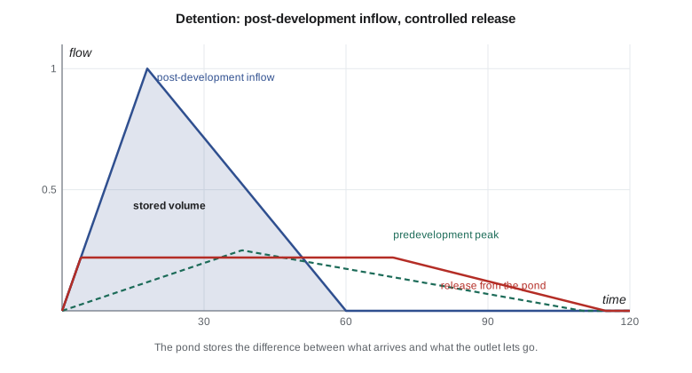
The storage a pond needs is the difference between the volume that arrives and the volume that leaves during the design storm. The modified rational method gives a simple estimate. For a series of storm durations, it computes the inflow volume as the post-development peak for that duration times the duration, and the outflow volume as the allowable release times the duration. The storm duration that gives the largest difference is the critical duration, and that difference is the storage needed. Longer storms have lower intensities but more volume, so the critical duration is often much longer than the time of concentration when the release rate is small.
# Rational method peaks and modified rational pond storage (SI)
A = 24.6                     # catchment area, ha
C_pre, C_post = 0.20, 0.50   # runoff coefficients before and after development
tc_pre, tc_post = 38.0, 18.0 # times of concentration, min
def i100(t):                 # illustrative 1:100 year IDF curve, mm/h
    return 1650 / (t + 9.5) ** 0.85
def i5(t):                   # illustrative 1:5 year IDF curve, mm/h
    return 820 / (t + 8.0) ** 0.85
def Q(C, i, A): return C * i * A / 360     # m3/s
for name, f in (("1:5 year", i5), ("1:100 year", i100)):
    print(f"{name:10} pre {Q(C_pre, f(tc_pre), A):5.2f} m3/s   post {Q(C_post, f(tc_post), A):5.2f} m3/s")
release = 2.5 * A / 1000     # allowable release, 2.5 L/s per ha in this course
print(f"allowable release {release * 1000:.0f} L/s")
best = (0, 0)
for t in range(10, 24 * 60, 5):
    inflow = Q(C_post, i100(t), A) * t * 60          # volume in during a storm of length t
    outflow = release * t * 60                        # constant release (conservative)
    if inflow - outflow > best[0]:
        best = (inflow - outflow, t)
print(f"storage needed {best[0]:,.0f} m3 for a {best[1]} min storm")
depth = 1.5
print(f"live storage depth {depth} m -> pond area at the water line about {best[0] / depth / 10000:.2f} ha")1:5 year pre 0.43 m3/s post 1.76 m3/s 1:100 year pre 0.85 m3/s post 3.37 m3/s allowable release 62 L/s storage needed 6,672 m3 for a 375 min storm live storage depth 1.5 m -> pond area at the water line about 0.44 ha
Development quadruples the peaks: the 1:100 year peak rises from 0.85 to 3.37 m³/s. With a release of only 62 L/s, the critical storm is long, about six hours, and the pond must hold about 6,700 m³ above its normal water level. At a live storage depth of 1.5 m that needs roughly 0.45 ha of water surface at the top of the active storage. The pond lot in the land budget is 1.45 ha because a wet pond also needs its permanent pool, a forebay to trap sediment, side slopes of 5:1 or flatter at the water's edge for safety, freeboard, a maintenance access road and a buffer to the nearest lots.
Outlets and controls
The release is controlled by an outlet structure, usually an orifice plate or a small pipe at the bottom of a manhole, sized so that at the maximum water level it passes no more than the allowable rate. Above the active storage, an emergency spillway carries flows from storms larger than the design storm safely past the pond without overtopping its berm. The outlet pipe then carries the water to the outfall, here down the coulee, where it must be protected from erosion with riprap or a drop structure. Outfalls in steep coulees are among the most delicate structures in a prairie subdivision.
Worked problem
Sizing an orifice
The Coulee Ridge pond must release no more than 62 L/s at a head of 1.5 m above the orifice centre. With a discharge coefficient of 0.60, what orifice diameter is needed?
Show solution
- \[A = \frac{Q}{C_d\sqrt{2gh}} = \frac{0.062}{0.60\sqrt{2 \times 9.81 \times 1.5}} = 0.0190 \text{ m}^2\]
- \[D = \sqrt{\frac{4A}{\pi}} = \sqrt{\frac{4 \times 0.0190}{\pi}} = 0.156 \text{ m}\]
Answer: An orifice of about 155 mm, rounded down so that the release is not exceeded.
Designing the pipes
The storm sewer network is designed reach by reach from the top of each catchment down to the pond. For each inlet, the engineer finds the area draining to it, its composite runoff coefficient and the time of concentration to that point, which grows downstream as the travel time in the pipes is added. The rational method gives the design flow at each point, and Manning's equation gives the pipe size and slope that carry it flowing full, with velocities high enough to keep sediment moving but not so high that they damage the pipe. The hydraulic grade line, the level the water would rise to in each manhole, is then checked against the pond's maximum water level, because a full pond backs water up the pipes. If the grade line rises above the catch basin grates in the lowest street, the pipes or the pond must change.
Catch basins are spaced along the gutters so that the spread of water across the pavement stays within the city's limit in the minor storm, and at every sag. Their leads to the main need enough cover to stay out of frost and enough slope to drain. The survey supports all of this: the street profiles and gutter grades come from Leah's design surfaces, and every catch basin, manhole and pipe end will be staked by Grant's crew and surveyed again as built.
Snowmelt, frozen ground and prairie storms
Prairie drainage has seasonal quirks. Many of the largest runoff events come not from summer thunderstorms but from spring snowmelt, sometimes with rain, on ground that is still frozen and absorbs nothing. Catch basins can be blocked by ice and snow, so overland routes carry more of the flow than the design storm suggests. Ponds may still be frozen when melt begins, and their outlets can be iced shut. Designers in the region therefore check ponds for a spring melt volume as well as for the summer design storm, keep outlet structures accessible for clearing, and avoid sags in streets where meltwater would freeze into ice sheets. Summer convective storms, on the other hand, can be very intense over small areas, which is exactly what the rational method's short durations are meant to capture.
Ponds as public places
A stormwater pond in a neighbourhood is also a park feature, and it must be safe. Side slopes near the water's edge are kept gentle, often 5 horizontal to 1 vertical or flatter for a bench around the normal water level, so that anyone who slips in can walk out. Signs warn that water levels rise quickly in storms. Native planting around the edge filters runoff, discourages geese and looks better than mown grass to the water. The city takes over the pond after a maintenance period and will dredge its forebay every several years, so the design includes an access road and a place to dewater sediment.
Low impact development
Ponds deal with the effects of runoff at the end of the pipe. Low impact development tries to reduce runoff at its source by letting more water soak in or evaporate where it falls: deeper topsoil on lots, roof leaders draining to lawns rather than driveways, bioretention cells in boulevards and parks, permeable pavement in lanes and parking areas, and swales instead of pipes where grades allow. On the prairies, clay soils, frozen ground in spring and the risk of wetting slopes near coulees limit infiltration, so these measures usually supplement rather than replace a pond. At Coulee Ridge the team specifies 300 mm of topsoil on lots and a bioretention strip in the collector's median, and avoids any infiltration within the geotechnical setback.
Coulee Geomatics: the stormwater plan
Brightwater's stormwater report is the engineering heart of the application, but the survey feeds it at every step: the drainage areas come from Ines's terrain model, the pond volumes from Leah's grading surfaces, the outfall route from Grant's survey of the coulee draw, and the pond lot boundary from the layout. When the city asks for the pond to be moved 10 m west to keep it out of the setback, Leah regrades the pond in an afternoon and Theo reruns the storage check; the pond loses a little volume and Sunil deepens it by 0.1 m to compensate.
Common mistakes
MistakeUsing the predevelopment time of concentration for the developed site.
InsteadDevelopment shortens tc; recompute it for the new flow paths.
MistakeSizing the pond for the storm duration equal to tc.
InsteadTest a range of durations; with small releases the critical storm is much longer.
MistakeTreating the pond lot area as the storage area.
InsteadAllow for the permanent pool, forebay, safe side slopes, freeboard, access and buffers.
MistakeEncouraging infiltration close to a coulee bank.
InsteadKeep infiltration out of the geotechnical setback; extra water can destabilize slopes.
Summary and key terms
- The minor system of pipes handles frequent storms; the major system of streets and overland routes handles rare ones.
- The rational method gives peak flow as C i A for small catchments, with intensity for a duration equal to tc.
- Development raises C and shortens tc, raising peaks several times.
- Release criteria limit post-development discharge; ponds store the excess.
- The modified rational method finds the critical storm duration and storage volume.
- Outlets control release, spillways pass larger storms, and low impact measures reduce runoff at its source.
- Minor system
- The piped storm sewer designed for frequent storms.
- Time of concentration
- The time for runoff to travel from the farthest point of a catchment to its outlet.
- Runoff coefficient
- The fraction of rainfall that becomes runoff in the rational method.
- IDF curve
- A relation giving rainfall intensity for each duration and return period.
- Live storage
- The pond volume between the normal water level and the maximum design level.
- Low impact development
- Measures that reduce runoff at its source by infiltration, evaporation and reuse.
Practice problems
Work each problem on paper first, then reveal the answer to check.
Why does development raise the peak flow more than the runoff volume?
Show answer
Runoff travels faster through gutters and pipes, shortening tc and raising intensity.
What is a composite runoff coefficient?
Show answer
The area-weighted average of the coefficients of the surfaces in a catchment.
Why can the critical storm for a pond be several hours long?
Show answer
With a small release rate, long storms deliver more volume than the outlet can pass.
What does an emergency spillway do?
Show answer
Carries flows larger than the design storm past the pond without overtopping the berm.
Why is a forebay used in a wet pond?
Show answer
It traps coarse sediment where it can be removed easily.
Why avoid infiltration near the coulee?
Show answer
Wetting the soils can raise groundwater and reduce slope stability.
Lesson quiz · 5 questions
Score 60% or more to complete this lesson.
Create a free account to save your progress, take quizzes and earn a certificate.