
GEOM-450 · Lesson 2 of 12 · 21 min
Zoning and subdivision regulations
Land cannot be divided simply because an owner wants to sell it in pieces. Every state and province controls the creation of new parcels, because subdivision commits a community to roads, pipes, schools and services for generations. The rules set out who decides, what plans must be in place first, what the applicant must provide, what the approving body must consider and what land or money the developer must give to the public in return. This lesson walks through those rules in Montana as Coulee Ridge moves from concept to approval.
Why subdivision is regulated
Before modern planning law, land was often divided into lots with no roads, no water and no drainage, and the cost of fixing these fell on later owners and the public. Speculative plats were drawn on paper far beyond any real demand, leaving scattered lots that could not be serviced efficiently. Subdivision control grew out of these problems. Its purposes are to make sure that new lots are suitable for their use, that they can be served with roads and utilities at reasonable public cost, that development fits the community's plans, and that the new parcels are described precisely enough to be registered and insured.
The planning framework in Montana
In Montana, subdivision is governed by the Montana Subdivision and Platting Act and, for larger cities, by the Montana Land Use Planning Act of 2023. The newer Act applies to cities of at least 5,000 people in counties of at least 70,000, which includes Great Falls. It requires such cities to adopt a land use plan, to bring their zoning and subdivision regulations into line with it and to concentrate public participation at the planning stage. A subdivision that complies with the adopted plan and regulations is then reviewed largely on technical grounds. Smaller towns and unincorporated county land remain under the older Act, which requires local governments to adopt subdivision regulations and review each subdivision against a set of statutory criteria.
The key idea is conformity. A subdivision must comply with the land use plan, the zoning and the subdivision regulations. If the land is outside the city, as part of Coulee Ridge is, it must first be annexed, and if its zoning does not allow the proposed lots, it must be rezoned. Zoning is a legislative decision made by the city commission after public process, and annexation and zoning often take longer than the subdivision review itself.
Zoning standards that shape the lots
Zoning sets the dimensions within which lots must be designed. For single-detached housing the main controls are minimum lot width, often called frontage, minimum lot depth, minimum lot area, front, side and rear setbacks, maximum site coverage and building height. Corner lots usually need extra width because the side yard facing the flanking street has a larger setback. Lots on curves and cul-de-sacs are usually measured at the front setback line, where the house will sit, rather than at the curved property line, which can be much shorter.
| District rule (course values) | Single-family residential |
|---|---|
| Minimum interior frontage | 40 ft |
| Minimum corner frontage | 45 ft |
| Minimum depth | 100 ft |
| Minimum area | 4,000 ft² |
| Front setback | 20 ft |
| Side setbacks | 5 ft each side |
These values are typical of single-detached districts in prairie cities but are course values, not quotations from any bylaw. The point is the method: every draft lot is checked against every rule before the plan goes to the city. Theo writes a short script to do this for the lots Leah has drafted, and adds a check of the park dedication described below.
# Check draft lots against the single-family district rules used in this course
MIN_FRONT, MIN_FRONT_CORNER, MIN_AREA, MIN_DEPTH = 40.0, 45.0, 4000.0, 100.0   # ft, ft, ft2, ft
lots = [  # name, frontage at the front setback line (ft), depth (ft), area (ft2), corner?
    ("B1-1", 50.0, 110, 5500, True),
    ("B1-2", 44.0, 110, 4840, False),
    ("B1-9", 40.0, 110, 4400, False),
    ("B2-1", 42.0, 110, 4620, True),
    ("B3-4", 36.0, 118, 5600, False),   # pie lot on the cul-de-sac bulb
    ("B3-7", 43.0, 90, 3870, False),    # shallow lot at the coulee edge
]
for name, f, d, a, corner in lots:
    need = MIN_FRONT_CORNER if corner else MIN_FRONT
    problems = []
    if f < need: problems.append(f"frontage {f} < {need}")
    if a < MIN_AREA: problems.append(f"area {a} < {MIN_AREA:.0f}")
    if d < MIN_DEPTH: problems.append(f"depth {d} < {MIN_DEPTH}")
    print(f"{name:5} {'corner' if corner else 'interior':8} {'OK' if not problems else '; '.join(problems)}")

# Park dedication on the sliding scale: 11 % of the area in lots of 1/2 acre or less
lots_area = 32.1                 # acres in residential lots, all under 1/2 acre
owing = 0.11 * lots_area
provided = 4.0 + 0.9             # neighborhood park + trail corridor beside the coulee
print(f"park owing {owing:.2f} ac, land provided {provided:.2f} ac")
short = owing - provided
if short > 0:
    print(f"shortfall {short:.2f} ac, cash in lieu at fair market value")
else:
print(f"surplus {-short:.2f} ac")B1-1 corner OK B1-2 interior OK B1-9 interior OK B2-1 corner frontage 42.0 < 45.0 B3-4 interior frontage 36.0 < 40.0 B3-7 interior area 3870 < 4000; depth 90 < 100.0 park owing 3.53 ac, land provided 4.90 ac surplus 1.37 ac
Three of the six lots fail. The second corner lot is too narrow for its flanking side yard, the pie lot on the cul-de-sac is too narrow at the setback line, and the shallow lot at the coulee edge fails both area and depth. Each failure has a different fix: widen the corner lot by taking width from its neighbor, move the front setback line deeper on the pie lot so it is measured where the lot is wider, and merge the shallow lot with the one beside it. Running the checks on every lot each time the layout changes catches problems long before the city's reviewer does.
Parks and dedications
Under the Subdivision and Platting Act, a subdivision must dedicate land for parks, or pay cash in lieu, on a sliding scale based on lot size: 11 percent of the area in lots of half an acre or less, 7.5 percent for lots over half an acre up to one acre, 5 percent for lots over one acre up to three acres and 2.5 percent for lots over three acres up to five acres. Minor subdivisions, lots over five acres and nonresidential subdivisions are exempt. Cities under the newer Land Use Planning Act set their own parkland rules in their regulations, so the Coulee Ridge team uses the sliding scale as its planning figure and confirms the current requirement with Claire.
Land for streets, alleys, trails and drainage is dedicated to the public on the final plat. Easements for utilities, drainage and access are shown and described on the plat or in recorded documents. The steep coulee slope at Coulee Ridge is not developable; the city prefers that it be dedicated as open space along with a trail corridor at the top of bank, and the parkland review decides how much of it counts toward the park requirement.
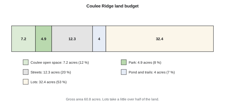
At Coulee Ridge, about 32 acres will be in lots of less than half an acre, so the sliding scale gives about 3.5 acres of park. The concept provides a 4.0-acre neighborhood park and a 0.9-acre trail corridor, 4.9 acres in all, a surplus of about 1.4 acres that the developer could offer as credit toward the next phase or reduce in a revised layout.
The application and its review
In Montana a subdivision begins with a pre-application meeting, followed by a preliminary plat with supporting information: an environmental assessment for larger subdivisions, a summary of probable impacts, a drainage plan and the documents needed for the state sanitation review. Under the Subdivision and Platting Act the governing body must consider the impact on agriculture, agricultural water user facilities, local services, the natural environment, wildlife and wildlife habitat, and public health and safety, and the subdivision must comply with the survey requirements, regulations and the sanitation rules. Under the Land Use Planning Act, a subdivision that complies with the plan, zoning and regulations is reviewed administratively within set deadlines, with the city's role focused on whether the standards are met.
Approval of the preliminary plat usually comes with conditions: improvements to be built or guaranteed, easements to be granted, covenants to be recorded and agency approvals to be obtained. The state Department of Environmental Quality reviews the water, wastewater, solid waste and storm drainage for each lot under the Sanitation in Subdivisions Act and issues a certificate of subdivision approval; its stormwater circular sets the design standards. Only when the conditions are met is the final plat approved and filed.
Rights and interests already on the land
Planning approval is not the only permission a subdivision needs. The title search at the start of the project shows the interests already registered against the land, and each one shapes the layout. At Coulee Ridge the list includes a right of way for a high-pressure gas pipeline across the north edge, a utility right of way for an overhead power line along the south road, and the irrigation district's right of way for a lateral canal, with the district's rights to deliver water to the farms beyond it. The pipeline operator sets rules for crossings, setbacks and ground disturbance, and must consent to any road or utility that crosses its right of way. The irrigation district must agree to any change to its lateral, and in practice the lateral will be piped where it passes through the new neighborhood.
Other approvals sit with state agencies. Work near the coulee may need a floodplain or stream permit if work affects the drainage, and consultation with the State Historic Preservation Office if federal money or permits are involved. Each of these has its own timeline, and each condition is listed in Ruth's tracking sheet so that none is forgotten at the end, when the plat is ready and only a missing consent stands in the way.
Off-site costs
New development draws on infrastructure outside its boundary: arterial streets, trunk sewers, storage tanks, treatment plants. Montana local governments may charge impact fees under the state impact fee law, based on a study showing the share of capacity the development uses, usually charged per dwelling unit at building permit or plat. The fees are a significant cost; lesson 11 includes them in the Coulee Ridge estimate.
Worked problem
Park dedication on a mixed subdivision
A subdivision creates 18 acres of lots of 0.4 acres each and 6 acres of lots of 1.5 acres each. Using the sliding scale, how much park area is owed?
Show solution
- \[\text{small lots: } 0.11 \times 18 = 1.98 \text{ acres}\]
- \[\text{large lots: } 0.05 \times 6 = 0.30 \text{ acres}\]
- \[\text{total} = 1.98 + 0.30 = 2.28 \text{ acres}\]
Answer: About 2.3 acres of park, or cash in lieu of equal value.
Coulee Geomatics: the approvals path
Claire's pre-application notes set out the path for Coulee Ridge: annexation of the part of the land still in the county, zoning under the city's code consistent with its land use plan, then the preliminary plat for phase 1 with the drainage plan and sanitation documents. She asks for a geotechnical setback line at the coulee before the open space boundary is fixed, and for a traffic study of the new collector's connection to the arterial street. Ruth builds the schedule backward from Dana's target sales date and finds that annexation and zoning, not the plat review, are the critical path.
Common mistakes
MistakeSubmitting a subdivision for land whose zoning does not allow the proposed lots.
InsteadConfirm the plans and zoning first; amend them before applying.
MistakeMeasuring the frontage of a cul-de-sac lot along its curved front line.
InsteadMeasure where the bylaw says, usually at the front setback line.
MistakeAssuming the sliding scale always applies inside a city.
InsteadCities under the newer Act may set their own parkland rules; confirm with the planner.
MistakeTreating conditions of approval as a formality.
InsteadConditions are binding; the plan cannot be registered or filed until they are met.
Summary and key terms
- Subdivision control ensures that new lots are usable, serviceable, consistent with plans and precisely described.
- In Montana, the Subdivision and Platting Act and the Land Use Planning Act govern subdivision, depending on the size of the city and county.
- Zoning sets lot frontage, depth, area and setbacks, which every lot must be checked against.
- Park dedication follows a sliding scale by lot size under the older Act, or the city's rules under the newer one.
- Approvals come with conditions on agreements, levies or fees, easements and technical approvals.
- Planning amendments are often the longest step in the schedule.
- Land use plan
- The plan a city must adopt under the Montana Land Use Planning Act to guide zoning and subdivision.
- Zoning
- Regulations dividing land into districts with permitted uses and dimensional standards.
- Preliminary plat
- The proposed subdivision layout submitted for review and conditional approval.
- Final plat
- The surveyed plat, approved and filed with the county, that creates the new lots.
- Park dedication
- Land or cash in lieu provided for parks as a condition of subdivision.
- Impact fee
- A charge for capital facilities outside a development that its residents will use.
Practice problems
Work each problem on paper first, then reveal the answer to check.
Why must zoning be in place before the subdivision application?
Show answer
The lots must conform to the zoning; without it the approving body cannot approve them.
Where is the frontage of a pie lot usually measured?
Show answer
At the front setback line, not along the curved front property line.
Which lots are exempt from the sliding-scale park dedication?
Show answer
Lots over five acres, minor subdivisions and nonresidential subdivisions, among others.
What is a typical condition of subdivision approval?
Show answer
An improvements agreement with a financial guarantee and state sanitation approval.
A corner lot is 12.8 wide where the corner rule asks for 13.5 (same units). Name a fix.
Show answer
Take width from the neighboring interior lot if it stays above its own minimum, or reduce the number of lots on the face.
Why did the Coulee Ridge schedule depend most on the planning stage?
Show answer
Plan amendments and zoning are political decisions with public hearings that often take longer than subdivision review.
Lesson quiz · 5 questions
Score 60% or more to complete this lesson.
Create a free account to save your progress, take quizzes and earn a certificate.