
GEOM-200 · Lesson 2 of 12 · 20 min
Shape of the Earth and datums
To say where something is, we first need a model of the thing it sits on. For a small building site a flat plane is good enough. For a highway, a pipeline, a national map or a satellite orbit it is not, and the curvature, the flattening and even the lumpy gravity field of the Earth start to matter. This lesson describes the three surfaces geomatics engineers use to model the Earth, explains how an ellipsoid is defined and how its curvature varies with latitude, and introduces the datums and reference frames that turn those mathematical models into coordinates people can share. CIV-250 lesson 9 applies these ideas to field surveying; here we look at where they come from and why they keep changing.
From sphere to ellipsoid
The Greek scholar Eratosthenes estimated the size of a spherical Earth in about 240 BCE by comparing the Sun's angle at noon in two Egyptian cities, and his result was within about 10 to 15 percent of the modern value. For almost two thousand years the sphere was the working model. In the late seventeenth century Isaac Newton argued that a rotating, fluid Earth should bulge at the equator and flatten at the poles. The question was settled in the 1730s when French expeditions measured the length of a degree of latitude in Lapland and near the equator in present-day Ecuador: a degree was longer in the north, which meant the Earth was flatter there. The best simple model of the Earth is therefore an oblate ellipsoid, a flattened sphere formed by rotating an ellipse about its shorter axis.
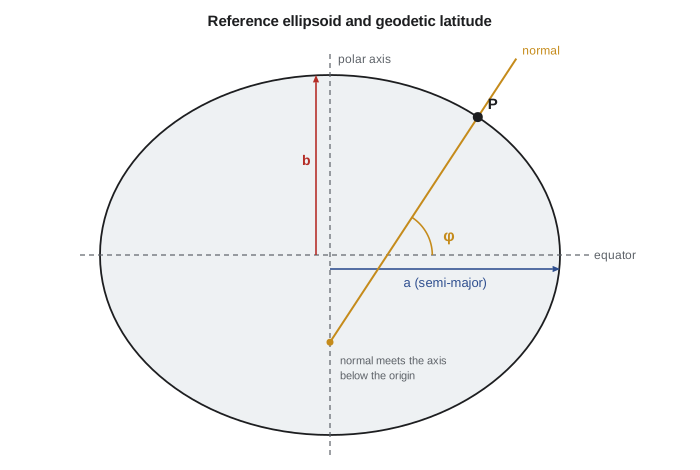
An ellipsoid is fixed by two numbers. Geodesists usually give the semi-major axis \(a\), the equatorial radius, and the flattening \(f\), which says how much shorter the polar semi-axis \(b\) is. Two other quantities, the first eccentricity squared \(e^2\) and the polar radius \(b\), follow from them:
The ellipsoid used in North America today is the Geodetic Reference System 1980 (GRS80), with \(a = 6\,378\,137\) m and \(1/f = 298.257\,222\,101\). The WGS84 ellipsoid used by GPS has the same semi-major axis and a flattening that differs only in the ninth significant figure, so for all practical purposes the two are identical. The polar radius is about 21.4 km shorter than the equatorial radius: a difference of only one part in 298, which is why the Earth looks perfectly round from space.
Curvature changes with latitude
Because the ellipsoid is flattened, its curvature is not the same everywhere or in every direction. Two radii of curvature describe it at a point of geodetic latitude \(\varphi\). The meridian radius \(M\) applies to north–south lines, and the prime vertical radius \(N\) applies to the east–west direction:
At the equator \(M\) is smallest, about 6,335 km, because the surface is most sharply curved north–south there; at the poles both radii are equal at about 6,400 km, because the surface is flattest. The geometric mean \(\sqrt{MN}\) is often used as a local radius of the Earth for reducing distances. These radii also tell us how long a degree is: one degree of latitude spans \(M \times \pi/180\), and one degree of longitude spans \(N \cos\varphi \times \pi/180\), which shrinks to zero at the poles.
Worked problem
How long is a degree at the project site?
Coulee Geomatics's Great Falls office is at latitude 47.50° N. Using GRS80, find \(M\), \(N\) and the ground lengths of one degree of latitude and one degree of longitude.
Show solution
- \[e^2 = 2f - f^2 = 0.006\,694\,380\]
- \[W = \Big(1 - e^2 \sin^2 47.50°\Big)^{1/2} = 0.998\,179\]
- \[N = a / W = 6\,389\,774\ \text{m} \qquad M = a(1-e^2)/W^3 = 6\,370\,179\ \text{m}\]
- \[1° \text{ of latitude} = M\pi/180 = 111.18\ \text{km} \qquad 1° \text{ of longitude} = N\cos\varphi\,\pi/180 = 75.34\ \text{km}\]
Answer: A degree of latitude is about 111.2 km and a degree of longitude about 75.3 km at Great Falls. One second of latitude is therefore about 30.9 m, so a coordinate given to five decimal places of a degree is good to about a meter.
The geoid: the Earth's true level surface
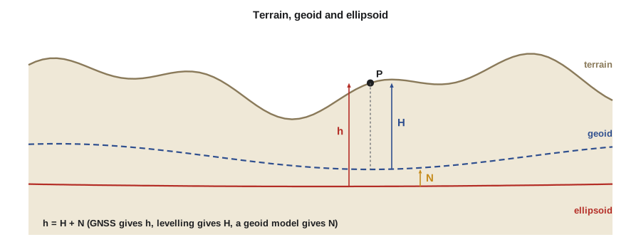
The ellipsoid is a mathematical convenience, but water does not follow it. Water follows gravity, and because mass inside the Earth is unevenly distributed, the surfaces of equal gravity potential are slightly lumpy. The geoid is the equipotential surface that best fits global mean sea level. It is the surface a still ocean would take if it could flow under the continents through narrow canals, and at every point it is perpendicular to the direction of a plumb line. Relative to the GRS80 ellipsoid, the geoid rises to about +85 m near Indonesia and falls to about −105 m south of India. Under southern Alberta and Montana it lies roughly 14 to 17 m below the ellipsoid.
The geoid matters because people care about heights that relate to water. A canal flows downhill only if the water surface drops in terms of gravity potential, not ellipsoid height. Elevations used in engineering, called orthometric heights \(H\), are measured from the geoid. GNSS measures ellipsoid heights \(h\). The geoid height \(N\) links them, and a geoid model computed from gravity measurements, satellite gravity missions and terrain data supplies \(N\) everywhere:
The symbol \(N\) is used for both the geoid height and the prime vertical radius; the meaning is always clear from context, but it is worth watching for when reading formulas.
What a datum does
An ellipsoid by itself floats in space. A geodetic datum fixes it to the Earth: it states where the ellipsoid's center is, how its axes are oriented, and what scale is used, and it is made usable by a network of monuments and permanent GNSS stations whose coordinates are published. Older, classical datums were fixed at a single origin point on the surface and fitted to one continent. The North American Datum of 1927 (NAD27) used the Clarke 1866 ellipsoid and an origin at Meades Ranch in Kansas. It fitted North America well but its center was hundreds of meters from the Earth's center of mass.
Modern datums are geocentric: the ellipsoid's center is placed at the Earth's center of mass, determined from satellite orbits. The North American Datum of 1983 (NAD83), adopted jointly by Canada and the United States, uses GRS80 and was originally designed to be geocentric, although later measurements showed its center to be about 2 m from the true center of mass. The same point can have NAD27 and NAD83 coordinates that differ by tens to more than a hundred meters, so every old plan must be read with its datum in mind.
Reference frames and a moving Earth
The Earth's crust is broken into plates that move by a few centimeters a year, and the ground also rises and falls with post-glacial rebound, earthquakes, groundwater pumping and tides. A modern datum is therefore realized as a reference frame: a set of station coordinates and velocities at a stated reference date called the epoch. The International Terrestrial Reference Frame (ITRF), computed from several space-geodetic techniques, is the global standard. Its latest version, ITRF2020, gives coordinates in which North American stations move by roughly 2 cm a year as the plate rotates. WGS84, the frame used by GPS, is kept aligned with ITRF to within a few centimeters.
For everyday use on one continent, a frame that moves with the plate is more convenient, because coordinates of stable monuments then stay nearly constant for decades. NAD83 is such a plate-fixed frame. Each time it is refined with better data it gets a new realization label, written in parentheses after the name.
In the United States the current realization is NAD83(2011), epoch 2010.00, maintained by the National Geodetic Survey (NGS) through the National Spatial Reference System (NSRS) and its network of Continuously Operating Reference Stations. Vertically, the official datum is still the North American Vertical Datum of 1988 (NAVD 88), realized by leveled benchmarks held to one tide station, which is known to contain errors of tens of centimeters to more than a meter across the country.
Modernization under way
NAD83 has known distortions and its center is offset from the true center of mass, so NGS is replacing NAD83 and NAVD 88 with a modernized NSRS. The North American Terrestrial Reference Frame of 2022 (NATRF2022), aligned with ITRF, will replace NAD83 and shift coordinates by roughly 1 to 2 m horizontally and up to a few meters in ellipsoid height. The North American-Pacific Geopotential Datum of 2022 (NAPGD2022), defined by a gravity-based geoid model, will replace NAVD 88. NGS released beta versions of the new frames and tools on September 15, 2026, for a public testing period of about six months, after which it plans to review feedback and approve the modernized system. Until then NAD83(2011) and NAVD 88 remain official.
| Item | Older system | Current system | Coming |
|---|---|---|---|
| Horizontal frame | NAD27 (Clarke 1866) | NAD83(2011), epoch 2010.00 | NATRF2022, aligned with ITRF |
| Vertical datum | NGVD 29 (leveling) | NAVD 88 (leveling) | NAPGD2022 (geoid-based) |
| Ellipsoid | Clarke 1866 | GRS80 | GRS80 |
Transformations between datums
Moving coordinates from one datum or frame to another is done with a transformation. Between two modern geocentric frames a seven-parameter Helmert transformation is common: three translations, three small rotations and a scale change, sometimes with time rates of each so that the epoch can be changed too. Between a classical datum and a modern one, the distortions in the old network are irregular, so national agencies publish grid-based transformations that interpolate shifts from a model. Geomatics engineers must use the official tools for the jurisdiction and record which transformation was applied, because two different transformations can give answers that differ by more than the accuracy of the survey.
# GRS80 ellipsoid: derived constants, radii of curvature and the length of a degree
import math

a = 6378137.0
f = 1 / 298.257222101
b = a * (1 - f)
e2 = 2 * f - f * f
print(f"b = {b:.3f} m, a - b = {(a - b) / 1000:.3f} km, e^2 = {e2:.9f}")

def radii(lat_deg):
    phi = math.radians(lat_deg)
    W = math.sqrt(1 - e2 * math.sin(phi) ** 2)
    N = a / W
    M = a * (1 - e2) / W ** 3
    return M, N

for lat in (0.0, 47.5, 49.7, 90.0):
    M, N = radii(lat)
    deg_lat = M * math.pi / 180 / 1000
    deg_lon = N * math.cos(math.radians(lat)) * math.pi / 180 / 1000
    print(f"lat {lat:5.2f}: M = {M:,.0f} m, N = {N:,.0f} m, "
          f"1 deg lat = {deg_lat:7.3f} km, 1 deg lon = {deg_lon:7.3f} km, "
f"sqrt(MN) = {math.sqrt(M * N):,.0f} m")b = 6356752.314 m, a - b = 21.385 km, e^2 = 0.006694380 lat 0.00: M = 6,335,439 m, N = 6,378,137 m, 1 deg lat = 110.574 km, 1 deg lon = 111.319 km, sqrt(MN) = 6,356,752 m lat 47.50: M = 6,370,179 m, N = 6,389,774 m, 1 deg lat = 111.181 km, 1 deg lon = 75.344 km, sqrt(MN) = 6,379,968 m lat 49.70: M = 6,372,624 m, N = 6,390,591 m, 1 deg lat = 111.223 km, 1 deg lon = 72.141 km, sqrt(MN) = 6,381,601 m lat 90.00: M = 6,399,594 m, N = 6,399,594 m, 1 deg lat = 111.694 km, 1 deg lon = 0.000 km, sqrt(MN) = 6,399,594 m
The output shows the flattening at work: the meridian radius grows from about 6,335 km at the equator to about 6,400 km at the pole, and a degree of longitude shrinks from about 111 km at the equator to nothing at the pole.
Common mistakes
MistakeTreating the ellipsoid as the surface that water follows.
InsteadWater follows the geoid; use orthometric heights for anything involving drainage.
MistakeAssuming WGS84 and NAD83 coordinates are the same because the ellipsoids match.
InsteadThe frames differ by about 1 to 2 m today; the datum and epoch, not just the ellipsoid, define coordinates.
MistakeUsing a single radius of 6,371 km for precise work.
InsteadUse M, N or their mean for the latitude and direction concerned.
MistakeTransforming between datums with an unofficial or unrecorded method.
InsteadUse the agency's published transformation and record it in the metadata.
Summary and key terms
- The Earth is modeled as an oblate ellipsoid; GRS80 has a = 6,378,137 m and 1/f = 298.257222101.
- The meridian radius M and prime vertical radius N vary with latitude; one degree of latitude is about 111 km.
- The geoid is the equipotential surface that best fits mean sea level; h = H + N links ellipsoid and orthometric heights.
- A datum fixes an ellipsoid to the Earth; modern datums are geocentric and realized as reference frames with an epoch.
- NAD83 is plate-fixed; ITRF and WGS84 are global and move relative to North America by about 2 cm a year.
- NATRF2022 and related systems are being introduced; NGS released beta versions in September 2026.
- Ellipsoid
- A surface formed by rotating an ellipse about its minor axis, used as a smooth model of the Earth.
- Flattening
- The ratio (a − b)/a describing how much an ellipsoid is flattened at the poles.
- Geoid
- The equipotential surface of the Earth’s gravity field that best fits global mean sea level.
- Geodetic datum
- A definition of the position, orientation and scale of an ellipsoid relative to the Earth.
- Reference frame
- The realization of a datum by station coordinates and velocities at an epoch.
- Epoch
- The date to which coordinates in a moving frame refer.
- Helmert transformation
- A seven-parameter similarity transformation between two three-dimensional frames.
Practice problems
Work each problem on paper first, then reveal the answer to check.
Find the polar radius b of an ellipsoid with a = 6,378,137 m and f = 1/298.257.
Show answer
\(b = a(1-f) = 6\,356\,752\) m.
At what latitude is a degree of longitude half as long as at the equator (sphere approximation)?
Show answer
Where \(\cos\varphi = 0.5\), at 60°.
A GNSS ellipsoid height is 1,032.40 m and the geoid height is −16.10 m. Find H.
Show answer
\(H = h - N = 1048.50\) m.
Why does a coordinate in ITRF need an epoch but a NAD83 coordinate of a stable monument changes little?
Show answer
ITRF is global, so the plate moves through it; NAD83 moves with the North American plate.
What are the seven parameters of a Helmert transformation?
Show answer
Three translations, three rotations and one scale factor.
Lesson quiz · 5 questions
Score 60% or more to complete this lesson.
Create a free account to save your progress, take quizzes and earn a certificate.