
GEOM-200 · Lesson 11 of 12 · 21 min
Land surveying and the profession in the US
Of all the work geomatics engineers do, land surveying is the part most closely tied to law. A boundary survey decides where one person's property ends and another's begins, and that decision affects mortgages, building permits, neighbors, counties and sometimes the courts. For that reason boundary surveying in the US is a licensed profession in every state: only professional land surveyors may carry out surveys that define or re-establish legal boundaries, and they are accountable to a state licensing board. This lesson explains how land in the US was divided, the Public Land Survey System of the West, how deeds and plats are recorded, the main kinds of boundary survey, how a land surveyor weighs evidence, and the route to licensure as a professional land surveyor through the national examinations and a state board. The detail of retracing and monumenting boundaries belongs to GEOM-410 Cadastral Surveying and Land Law; the field techniques are in CIV-250.
Why boundaries need surveyors
A legal boundary is not a line on a map but a relationship between people and land, created by a grant, a subdivision, a deed or a plan and fixed on the ground by monuments. Maps and GIS parcel layers, as lesson 9 explained, only represent boundaries. When the paper record and the ground disagree, as they often do after a century of fences, roads, lost monuments and changing technology, someone with knowledge of both measurement and law must decide where the boundary is. That person is the land surveyor, and the decision rests on evidence, not on coordinates alone.
The basic principle, shared across North American common-law jurisdictions, is that original monuments set in the original survey, and accepted by the parties, control over measurements and over coordinates computed later. A surveyor retracing a boundary looks for the footsteps of the original surveyor. Where original monuments are found undisturbed, they mark the boundary even if the distances between them differ from those on the plan. Where they are lost, the surveyor restores their positions from the best available evidence, in an order of priority that the courts have developed: natural boundaries, original monuments, fences and occupation of long standing, and finally measurements recorded on plans.
Dividing the land: the Public Land Survey System
In the original thirteen colonies, Texas, and other areas settled early, land was described by metes and bounds, a sequence of bearings, distances and natural features around each parcel, often with irregular results. For the public domain west of the original states, Congress adopted the Land Ordinance of 1785, which created the Public Land Survey System (PLSS). It divides land into a rectangular grid and now covers 30 states, including all of Montana. The Bureau of Land Management (BLM), through its cadastral survey program, remains responsible for surveys of federal lands under the Manual of Surveying Instructions.
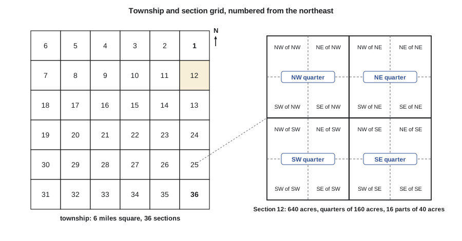
The PLSS divides land into townships six miles square, each containing 36 sections of one square mile (640 acres). Townships are numbered north or south from a baseline, and ranges east or west from a principal meridian; there are 37 principal meridians, each with its own initial point. Montana uses the Montana Principal Meridian, whose initial point was established in 1867 on a hill near Willow Creek. Sections are numbered from 1 in the northeast corner of the township, running west along the top row and then back and forth to 36 in the southeast corner. Sections are divided into quarter sections of 160 acres, and into quarter-quarter sections of 40 acres, which are the units in many legal descriptions. Because meridians converge toward the pole, the grid is adjusted along standard parallels (correction lines) every few townships, and the excess or deficiency of area is placed in the north and west tiers of each township, which is why some lots there are irregular.
Worked problem
Reading a legal land description
The Coulee Ridge subdivision is being created from the northeast quarter of Section 12, Township 20 North, Range 3 East, Montana Principal Meridian, written NE¼ Sec. 12, T20N, R3E, M.P.M. How large is the parent parcel, and roughly where is it relative to the baseline and the principal meridian?
Show solution
- \[\text{area} = \frac{640}{4} = 160\ \text{acres} \approx 64.7\ \text{ha}\]
- \[\text{north of the baseline} \approx (20 - 1) \times 6 = 114\text{–}120\ \text{miles}\]
- \[\text{east of the principal meridian} \approx (3 - 1) \times 6 = 12\text{–}18\ \text{miles}\]
- \[\text{Section 12} \to \text{east column, second row from the north}\]
Answer: The description locates the parent parcel uniquely and gives its nominal area. The actual area, and the exact positions of the quarter corners, come from the original survey monuments and any later surveys, which Ruth's crew must find and tie before the subdivision plan can be prepared.
Recording land: deeds, plats and title insurance
Most of the US uses a recording system, in which deeds, plats, easements and other documents are filed with the county recorder, and anyone claiming an interest searches the records. The government does not guarantee title; instead, buyers and lenders rely on title insurance, and title companies often require an ALTA/NSPS Land Title Survey for commercial property. In Montana, plats of subdivision and certificates of survey prepared by a professional land surveyor are filed with the county clerk and recorder under the Montana Subdivision and Platting Act, after review by the local government where required.
Kinds of legal survey
Professional land surveyors in the US carry out several kinds of boundary survey. Subdivision plats create new lots and streets and set monuments at their corners. Retracement surveys find or restore existing boundaries described in deeds and plats. Right-of-way surveys define corridors for pipelines, power lines, highways and railroads. ALTA/NSPS Land Title Surveys, carried out to national standards jointly adopted by the American Land Title Association and the National Society of Professional Surveyors, show boundaries, improvements, easements and encroachments for commercial transactions; the current 2026 standards took effect on February 23, 2026. Mortgage inspections, condominium plats and surveys of mining claims and federal lands complete the list.
Every legal survey ends with a plan or plat that shows the boundaries, monuments found and placed, measurements, the coordinate system and any evidence of conflict. The surveyor signs and seals it, taking professional responsibility for its correctness. In most jurisdictions the plan must meet published standards for content, accuracy and monumentation.
Evidence and judgment
Boundary decisions combine measurement with weighing evidence. A surveyor retracing an old lot will search the records for the original plan and any later surveys, look on the ground for iron posts, stones, wooden posts or their remains, measure fences and buildings, interview neighbors and compare everything with the record. Modern GNSS and total station measurements locate the evidence precisely, but they do not decide which piece of evidence governs. When the evidence conflicts, the surveyor applies the rules of priority and, where the conflict cannot be resolved by survey, advises the clients that the matter may require agreement or a court decision.
# Comparing found monuments with the record: which one is out of place?
import math

# Record (plan) distances and bearings around a lot, from corner A clockwise
record = [("A", "B", 90.0, 30.480), ("B", "C", 180.0, 45.720),
          ("C", "D", 270.0, 30.480), ("D", "A", 0.0, 45.720)]
# Coordinates of monuments found in the field (project coordinates, m)
found = {"A": (1000.000, 5000.000), "B": (1030.471, 5000.012),
         "C": (1030.493, 4954.284), "D": (1000.266, 4954.243)}

def inverse(p, q):
    dx, dy = q[0] - p[0], q[1] - p[1]
    return math.degrees(math.atan2(dx, dy)) % 360, math.hypot(dx, dy)

print("Line  record az/dist        measured az/dist        diff (m)")
for a, b, az_r, d_r in record:
    az_m, d_m = inverse(found[a], found[b])
    print(f"{a}-{b}   {az_r:7.3f} {d_r:8.3f}     {az_m:8.4f} {d_m:8.3f}     {d_m - d_r:+.3f}")

# Area by the shoelace formula from found monuments and from the record
pts = [found[k] for k in "ABCD"]
area = abs(sum(x1 * y2 - x2 * y1 for (x1, y1), (x2, y2) in zip(pts, pts[1:] + pts[:1]))) / 2
print(f"Area from found monuments {area:.1f} m2, record area {30.480 * 45.720:.1f} m2")

# Where would D be if placed from A by record measurements?
D_record = (found["A"][0], found["A"][1] - 45.720)
dx, dy = found["D"][0] - D_record[0], found["D"][1] - D_record[1]
print(f"Found D differs from record position by {math.hypot(dx, dy):.3f} m (E {dx:+.3f}, N {dy:+.3f})")Line record az/dist measured az/dist diff (m) A-B 90.000 30.480 89.9774 30.471 -0.009 B-C 180.000 45.720 179.9724 45.728 +0.008 C-D 270.000 30.480 269.9223 30.227 -0.253 D-A 0.000 45.720 359.6669 45.758 +0.038 Area from found monuments 1388.2 m2, record area 1393.5 m2 Found D differs from record position by 0.269 m (E +0.266, N -0.037)
Lines A–B and B–C agree with the record within a centimeter, which is normal for an old survey, but C–D is 25 cm short, D–A is 4 cm long and turned by about 20 minutes of arc, and the found D sits about 27 cm east of where the record puts it. Both lines that are wrong meet at D, which points to D rather than to the other corners. The numbers alone do not decide what to do. If the monument at D is an original, undisturbed and accepted by the neighbors, it may still govern; if there is evidence it was moved, perhaps by a fence builder or a road grader, the surveyor may restore D from the record and the other corners. The calculation tells the surveyor where to look harder.
The profession in the US
Land surveying in the US is regulated by the states. Every state licenses professional land surveyors (PLS, also called PS or RLS in some states) through a state board, sets minimum technical standards and disciplines licensees. In Montana, the Board of Professional Engineers and Professional Land Surveyors licenses both professions. Surveys of federal lands are carried out by the BLM's cadastral surveyors or by surveyors working under its instructions, and some federal work requires particular qualifications. Geomatics engineers who practice engineering, as distinct from boundary surveying, are licensed as professional engineers, often by the same board, and some surveyors hold both licenses.
Becoming a professional land surveyor has three parts: education, experience and examinations. The National Council of Examiners for Engineering and Surveying (NCEES) writes the two national examinations. The Fundamentals of Surveying (FS) exam is usually taken near the end of a degree; passing it, along with the state's requirements, allows registration as a land surveyor intern or surveyor in training (LSI or SIT). After several years of progressive experience under a licensed surveyor, the candidate takes the Principles and Practice of Surveying (PS) exam. Most states also set a state-specific examination or requirement covering their own laws, land systems and standards. The required combination of degree and years of experience varies by state, and the board's rules are the authority. In Montana, candidates apply to the Board of Professional Engineers and Professional Land Surveyors with their NCEES record.
Once licensed, surveyors must keep their competence up to date through continuing professional development, follow a code of ethics and practice only within their competence. Their seal on a plan is a public promise that the survey meets the standards; the professional body exists to make sure that promise can be trusted.
Ethics and the public interest
Land surveyors serve their clients, but their first duty is to the public and to the integrity of the land system. A surveyor cannot move a boundary to suit a client, must report evidence that harms the client's position, and must respect the rights of neighbors, who are not clients but are affected by every boundary decision. Surveyors also work within Indigenous rights and treaty contexts: reserve boundaries, treaty land entitlement settlements and land claims all depend on surveys, and surveyors increasingly work with Indigenous communities as clients and partners in managing their own lands.
Ruth Albrecht, PLS and PE, signs the subdivision plats for Coulee Ridge and supervises Grant's boundary crews. Leah, the co-op student, is working toward a geomatics engineering degree and plans to take the FS exam in her final year; her time on boundary surveys at Coulee Geomatics will count toward the progressive experience the Montana board requires before the PS exam.
Common mistakes
MistakeTreating computed coordinates as stronger than original monuments.
InsteadOriginal undisturbed monuments generally control; weigh evidence by the rules of priority.
MistakeRelying on GIS parcel maps for boundary decisions.
InsteadSearch the registered or recorded plans and find the monuments on the ground.
MistakeAssuming every jurisdiction has the same rules.
InsteadCheck the statute, regulations and standards where the land lies.
MistakeAdvocating for a client in a boundary dispute.
InsteadReport the evidence impartially; the surveyor's duty is to the public and the land system.
Summary and key terms
- Boundary surveying in the US is a licensed profession in every state.
- The PLSS divides the public domain into townships of 36 sections numbered from the northeast corner.
- The US relies on recording systems backed by title insurance.
- Original undisturbed monuments generally control over later measurements.
- NCEES writes the FS and PS exams; state boards license professional land surveyors.
- The surveyor's seal is a promise to the public that the survey meets the standards.
- Public Land Survey System
- The rectangular survey system dividing the US public domain into townships and sections.
- Quarter-quarter section
- A 40-acre division of a PLSS section; each section has 16.
- Recording system
- A land system in which documents are filed publicly but title is not guaranteed.
- ALTA/NSPS survey
- A land title survey for commercial property made to national standards.
- Metes and bounds
- A description of land by a sequence of bearings, distances and features.
- NCEES
- The national council that writes the FS and PS surveying examinations.
- Original monument
- A monument set in the original survey that created a boundary.
Practice problems
Work each problem on paper first, then reveal the answer to check.
How many quarter-quarter sections are in a quarter section?
Show answer
Four, each of 40 acres.
In which corner of a PLSS township is Section 36?
Show answer
The southeast corner.
Why do rural roads on the grid jog at intervals?
Show answer
The grid is offset at correction lines to account for converging meridians.
Original monument A is undisturbed but 0.15 m from its record position. Which governs?
Show answer
Generally the original monument, if it is accepted as original and undisturbed.
Name the two NCEES exams for land surveyors.
Show answer
Fundamentals of Surveying (FS) and Principles and Practice of Surveying (PS).
Lesson quiz · 5 questions
Score 60% or more to complete this lesson.
Create a free account to save your progress, take quizzes and earn a certificate.