
GEOM-200 · Lesson 1 of 12 · 20 min
What geomatics engineers do
Every map on a phone, every property line, every bridge alignment, every flood model and every self-driving car's sense of where it is depends on someone having measured the Earth carefully and organized the results so that others can trust them. Geomatics engineering is the discipline that does this work. It brings together surveying, geodesy, satellite positioning, photogrammetry, remote sensing, laser scanning, hydrography and geographic information systems into one field concerned with acquiring, modeling, analyzing and managing spatial information. This course is an overview of the whole discipline. Field surveying itself is taught in detail in CIV-250 Surveying & Geomatics and in GEOM-210 Surveying I, which share the same lessons; here we look at how all the pieces fit, why each one matters, and what a geomatics engineer actually does on a working day.
A working definition
The word geomatics comes from geodesy and informatics. It was coined in Canada in the late 1960s and 1970s, when universities and government agencies began combining traditional surveying with computing. Today the term covers any engineering work whose main product is reliable information about location, shape, size and change. A geomatics engineer answers four kinds of questions: where something is, how big or what shape it is, how it is changing, and how all of that should be stored, combined and shared so that others can make decisions from it.
Two ideas run through every part of the discipline. The first is that every measurement has an uncertainty, and that the uncertainty must be estimated and reported along with the value. A coordinate without a stated accuracy is only half an answer. The second is that every coordinate belongs to a reference system. A list of numbers means nothing until we know the datum, the projection, the units and the epoch to which they refer. Most expensive mistakes in geomatics come from forgetting one of these two ideas.
A short history
Measuring land is one of the oldest technical professions. Egyptian rope-stretchers re-established field boundaries after each Nile flood, Roman agrimensores laid out roads and colonies with a sighting instrument called the groma, and by the eighteenth century national triangulation surveys in France and Britain were measuring chains of triangles hundreds of kilometers long to fix the shape of the Earth. North America was largely settled on the basis of rectangular land surveys: the Dominion Land Survey in western Canada from 1871 and the Public Land Survey System in the United States from 1785. Those surveys are still the legal framework for most rural property in the prairie provinces and the western states.
The tools changed dramatically in the second half of the twentieth century. Electronic distance measurement replaced steel tapes in the 1960s and 1970s, aerial photography made mapping of whole countries practical, computers made least-squares adjustment routine, and satellite positioning, which began with the US Transit system and matured with GPS in the 1990s, made it possible to fix a position anywhere on Earth to a few centimeters. Lidar, digital cameras, drones and cloud computing have since turned geomatics into a data-rich discipline where the challenge is often managing and checking huge volumes of measurements rather than collecting them.
The main branches
It helps to think of the discipline as a set of measurement techniques feeding a common set of reference frames and a common information system.
| Branch | What it measures or does | Typical products |
|---|---|---|
| Surveying | Distances, angles and height differences with total stations, levels and GNSS | Control networks, topographic plans, layout stakes, as-built surveys |
| Geodesy | The shape, gravity field and rotation of the Earth | Datums, geoid models, reference frames, coordinate transformations |
| Satellite positioning | Positions from GNSS signals | Control coordinates, real-time positions for machines and vehicles |
| Photogrammetry | 3D geometry from overlapping images | Orthophotos, surface models, mapped features |
| Remote sensing | Reflected or emitted energy from aircraft and satellites | Land cover maps, change detection, crop and flood monitoring |
| Laser scanning (lidar) | Millions of ranges from a pulsed laser | Point clouds, terrain models, building and asset models |
| Hydrography | Water depths and the shape of the bed | Nautical charts, dredging volumes, scour surveys |
| Geographic information systems | Stores, analyses and displays spatial data | Maps, spatial databases, decision tools |
| Land surveying (cadastral) | The legal boundaries of land | Survey plans, monuments, subdivision plans |
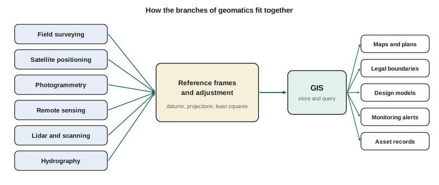
Where geomatics engineers work
Geomatics graduates work for surveying and engineering firms, cities and counties, state departments of transportation, federal agencies, utilities, energy and mining companies, agriculture businesses, defense, software companies and research groups. In Montana, where this course's running examples are set, highway work, agriculture, mining, oil and gas and federal land management employ many geomatics professionals. At the federal level, the National Geodetic Survey maintains the National Spatial Reference System, the US Geological Survey produces national maps and elevation data, NOAA's Office of Coast Survey charts navigable waters, and the Bureau of Land Management maintains the public land survey records.
Job titles vary widely: geomatics engineer, survey engineer, land surveyor, GIS analyst, remote sensing specialist, hydrographer, photogrammetrist, geodesist and geospatial developer are all common. Many people move between these roles over a career, because the underlying ideas are shared.
Meet Coulee Geomatics
The examples in this course follow Coulee Geomatics, an invented firm based in Great Falls, Montana, that you may already know from CIV-250. The principal is Ruth Albrecht, a professional land surveyor and professional engineer. Grant Okonkwo is the senior party chief, Theo Martel is a survey technologist who manages the firm's data, and Leah Tran is a co-op engineering student. For this course the firm has grown: Marcus Fehr runs its GIS group, and Ines Dahl, a remote sensing specialist, handles drone, lidar and satellite projects. Throughout the term the firm works on four projects: finishing the Coulee Ridge subdivision, mapping an irrigation district's canals, surveying the Missouri River near a highway bridge for a scour study, and preparing a pipeline right-of-way.
A day in the life
On a Tuesday in May, Leah's day shows how varied the work can be. At 7:00 she joins Grant to check control on the bridge project, occupying two monuments with GNSS receivers while a total station measures a third, so that the three methods confirm each other. By 10:00 Ines is flying a small drone over a section of canal, and Leah places and measures ground control targets that will tie the imagery to the project coordinate system. After lunch, back in the office, Theo shows her how the morning's GNSS files are processed and how the resulting coordinates are checked against the published values. Late in the afternoon Marcus asks her to load the new canal centerline into the irrigation district's GIS and to flag every place where it crosses a road, a pipeline or a property line. Before she leaves, Ruth asks her to look up the registered plan for a lot whose corner pin the crew could not find.
Each of those tasks belongs to a different branch, but they share the same discipline: every observation is checked, every coordinate carries its reference system, and every product records how it was made. That shared discipline is what makes geomatics a single profession rather than a collection of unrelated technologies.
Accuracy, precision and fitness for purpose
Every geomatics project begins with a question: how accurate does the answer need to be? A national land cover map may be useful with positions good to 30 m. A property boundary may need a few centimeters. A tunnel breakthrough or a machine alignment may need millimeters. Choosing the method, the equipment and the amount of checking depends on that answer, and over-specifying is almost as wasteful as under-specifying.
Precision describes how closely repeated measurements agree; accuracy describes how close they are to the true value. A badly calibrated instrument can produce precise but inaccurate results, which is why calibration and independent checks matter. Geomatics engineers express accuracy statistically, most often as a root mean square error (RMSE) computed from independent checkpoints, or as a confidence interval such as 95 percent.
Worked problem
Is the drone map good enough?
Ines's drone surface model of a canal section is tested against five checkpoints measured independently with GNSS. The height differences (model minus checkpoint) are +0.04, −0.06, +0.02, +0.05 and −0.03 m. The irrigation district requires a vertical RMSE of no more than 0.10 m. Does the model meet the requirement?
Show solution
- \[\text{sum of squares} = 0.0016 + 0.0036 + 0.0004 + 0.0025 + 0.0009 = 0.0090\ \text{m}^2\]
- \[\text{RMSE} = \sqrt{0.0090 / 5} = \sqrt{0.0018} = 0.042\ \text{m}\]
- The mean difference is +0.004 m, so there is no significant bias.
Answer: The vertical RMSE is about 0.04 m, well inside the 0.10 m requirement. In practice more checkpoints would be used, spread across the whole area and across different ground types, because five points give only a rough estimate.
Professional responsibility
Geomatics information is relied on by people who never see how it was made. A homeowner relies on a boundary survey when building a fence; a contractor relies on control when placing a bridge pier; a pilot relies on a chart when landing. For that reason some geomatics work is regulated. In the United States, boundary surveying is restricted to professional land surveyors licensed by each state; in Montana the licensing board is the Board of Professional Engineers and Professional Land Surveyors. Professional engineers also do geomatics work under their own licenses, and federal surveys of public lands follow the Bureau of Land Management's rules. Lesson 11 covers the profession in detail.
Even where a task is not legally restricted, the professional habits are the same: document the reference system, report uncertainty honestly, keep field notes and raw data, and never present a product as more accurate than it is. Coulee Geomatics stamps every deliverable with a metadata block stating the datum, projection, units, date, method and estimated accuracy, and Ruth will not release a product without one.
Geomatics and the rest of engineering
Geomatics engineers rarely work alone. On a highway project they set the control that every other discipline uses, model the existing ground for the designers, stake the design for the contractor, monitor settlement during construction and record the finished work. On an environmental study they map habitats, model drainage and detect change over years. On a smart-city project they build the 3D base model and keep it current. In each case the geomatics engineer is the person responsible for making sure that everyone's coordinates agree. Lesson 12 returns to this theme with a full project from start to finish.
How this course is organized
Lessons 2 to 4 cover the foundations: the shape of the Earth and datums, coordinate systems, and the basic measurements of distance, angle and height. Lessons 5 to 10 survey the measurement technologies: instruments, satellite positioning, photogrammetry and remote sensing, lidar, GIS and hydrography. Lesson 11 describes land surveying and the profession, and lesson 12 follows a project through its life. Each lesson includes worked examples and short Python programs, because almost all modern geomatics work is done with software, and understanding what the software computes is part of being able to trust it.
# Accuracy of a surface model against independent checkpoints
import math

diffs = [0.04, -0.06, 0.02, 0.05, -0.03]   # model minus checkpoint, m
n = len(diffs)
mean = sum(diffs) / n
rmse = math.sqrt(sum(d * d for d in diffs) / n)
sd = math.sqrt(sum((d - mean) ** 2 for d in diffs) / (n - 1))
print(f"checkpoints : {n}")
print(f"mean (bias) : {mean:+.3f} m")
print(f"std dev     : {sd:.3f} m")
print(f"RMSE        : {rmse:.3f} m")
print(f"95% vertical (1.96 x RMSE): {1.96 * rmse:.3f} m")
print("meets 0.10 m RMSE spec:", rmse <= 0.10)checkpoints : 5 mean (bias) : +0.004 m std dev : 0.047 m RMSE : 0.042 m 95% vertical (1.96 x RMSE): 0.083 m meets 0.10 m RMSE spec: True
The 95 percent value printed at the end follows a common convention in mapping accuracy standards: if errors are random and normally distributed, about 95 percent of them will be smaller than 1.96 times the RMSE. Standards differ in detail, so the standard named in a contract always governs.
Common mistakes
MistakeReporting coordinates without the datum, projection, units and epoch.
InsteadAttach a metadata statement to every coordinate list, drawing and dataset.
MistakeTreating precision as accuracy.
InsteadCheck against independent, more accurate measurements and calibrate instruments.
MistakeChoosing the most accurate method for every job.
InsteadMatch the method and checking effort to the accuracy the decision actually needs.
MistakeAssuming geomatics means only field surveying.
InsteadRemember geodesy, imaging, lidar, hydrography and GIS, and how they connect.
Summary and key terms
- Geomatics engineering acquires, models, analyses and manages spatial information.
- Every measurement has an uncertainty, and every coordinate belongs to a reference system.
- The main branches are surveying, geodesy, satellite positioning, photogrammetry, remote sensing, lidar, hydrography, GIS and land surveying.
- Accuracy is usually reported as RMSE against independent checkpoints, often with a 95 percent value of 1.96 × RMSE.
- The required accuracy should drive the choice of method.
- Boundary surveying is a licensed activity, and all geomatics work relies on documented, checkable results.
- Geomatics
- The engineering discipline of acquiring, modeling, analyzing and managing spatial information.
- Precision
- How closely repeated measurements agree with each other.
- Accuracy
- How close a measurement or product is to the true value.
- RMSE
- Root mean square error, a summary of the differences between measured and check values.
- Checkpoint
- An independently measured point used to test the accuracy of a product.
- Metadata
- Information describing how, when and in what reference system data were produced.
Practice problems
Work each problem on paper first, then reveal the answer to check.
Name four branches of geomatics and one product of each.
Show answer
For example: surveying (topographic plan), photogrammetry (orthophoto), hydrography (chart), GIS (spatial database).
Differences at four checkpoints are 0.10, −0.10, 0.05 and −0.05 m. Find the RMSE.
Show answer
\(\sqrt{(0.01+0.01+0.0025+0.0025)/4} = 0.079\) m.
A product has a horizontal RMSE of 0.20 m. Estimate the 95 percent value.
Show answer
About \(1.96 \times 0.20 = 0.39\) m (for a single component).
Why can a precise instrument still give inaccurate results?
Show answer
A systematic error such as poor calibration shifts all readings by the same amount.
Which two pieces of information must accompany every coordinate?
Show answer
Its reference system (datum, projection, units, epoch) and its uncertainty.
Lesson quiz · 5 questions
Score 60% or more to complete this lesson.
Create a free account to save your progress, take quizzes and earn a certificate.