
GEOM-200 · Lesson 10 of 12 · 21 min
Hydrography
Hydrography is the branch of geomatics that measures and describes the beds of oceans, lakes and rivers, the water above them and the shorelines around them. Its oldest purpose is safe navigation: nautical charts show depths, hazards and aids to navigation so that ships do not run aground. Today hydrographic data also serve port and harbor engineering, dredging, offshore energy, cable and pipeline routes, fisheries habitat, coastal flood and erosion studies, river engineering, reservoir sedimentation and bridge scour inspection. Hydrography is a meeting point of geodesy, acoustics, positioning and data processing, and it has its own standards and professional certification. This lesson introduces depth measurement by sound and light, the corrections that turn raw soundings into reliable depths, water levels and vertical datums, the survey platforms used, and inland hydrography of the kind a firm on the Prairies or Plains carries out. GEOM-360 Hydrographic Surveying covers the subject in detail.
Measuring depth
For centuries depth was measured with a lead line, a weighted rope marked in fathoms, swung ahead of a moving ship. In shallow rivers, surveyors still sometimes use a graduated sounding pole or a rod with a wide foot that does not sink into soft mud. Almost all modern depth measurement, however, uses sound. An echo sounder transmits a pulse of sound from a transducer below the waterline and measures the time until the echo returns from the bed. Sound travels about 1,500 m/s in sea water and about 1,400 to 1,480 m/s in fresh water, depending on temperature, so the depth below the transducer is half the travel time multiplied by the sound speed.
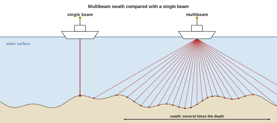
A single-beam echo sounder measures one depth directly beneath the vessel, building a profile along the vessel's track. Survey lines are run at regular spacing, and depths between lines are interpolated, so features smaller than the line spacing can be missed. A multibeam echo sounder sends a fan of hundreds of narrow beams across the track and measures a depth for each, covering a swath several times the water depth wide. Multibeam systems give complete coverage of the bed, so that wrecks, boulders, scour holes and debris can be found, and they are the standard for charting and for detailed engineering surveys. Side-scan sonar, towed or hull-mounted, produces acoustic images of the bed that show objects and textures clearly but does not measure depths precisely.
The sound speed problem
Sound speed in water depends on temperature, salinity and pressure. In a river, temperature dominates; in the ocean, all three matter, and the water forms layers with different speeds. A depth computed with the wrong sound speed is wrong in proportion: an error of 15 m/s, about 1 percent, gives a 10 cm error in 10 m of water. For multibeam systems the problem is worse, because the outer beams travel at an angle and are bent (refracted) as they pass through layers with different speeds, curving the edges of the swath up or down unless a full sound speed profile is applied.
Hydrographers therefore measure the sound speed regularly, with a profiler lowered through the water column, and continuously at the transducer face. On a river survey, a profile at the start and end of the day and whenever the water conditions change, such as below a tributary or a power plant discharge, is usual practice. The transducer's depth below the waterline, its draft, must also be measured, along with any change in draft as the vessel speeds up and squats lower in the water.
Positioning and motion
Every sounding must be positioned. Modern survey vessels use GNSS, usually RTK or PPP, to position the antenna, combined with a motion sensor or inertial system that measures the vessel's roll, pitch, heave and heading many times a second. Roll and pitch tilt the beams; heave moves the transducer up and down with the waves; heading turns the swath. The offsets between the GNSS antenna, the motion sensor and the transducer are measured precisely, often by a total station survey of the vessel on land, and calibration lines are run over a sloping or flat bed to find small timing and angular misalignments, called the patch test.
Before satellite positioning, hydrographic surveys were positioned by sextant angles to shore marks, by theodolite intersection from shore or by radio positioning systems. The change to GNSS has made positions more accurate and continuous, and it has also allowed the vertical position of the vessel to be measured directly, changing how depths are reduced to a datum.
Water levels and vertical datums
Measured depths are referred to the water surface at the moment of measurement, but the water surface moves: with tides in the ocean, with wind, seasonal runoff and dam operations in lakes and rivers. To be useful, soundings must be reduced to a fixed vertical datum. For navigation charts, the chart datum is a low water surface, so that the charted depth is the least depth a mariner can usually expect. Engineers working on bridges, intakes and flood defenses instead need bed elevations in the same land vertical datum used for the rest of the project.
In the US, NOAA's Office of Coast Survey produces nautical charts, and NOAA's Center for Operational Oceanographic Products and Services runs the National Water Level Observation Network. Charts use mean lower low water as chart datum in tidal waters and a low water datum on the Great Lakes. The US Army Corps of Engineers surveys federal navigation channels, including the inland river system. Inland projects in Montana normally reduce soundings to NAVD 88 elevations through RTK GNSS on the vessel, or through water level readings tied by leveling to bench marks on the bank.
With GNSS heights on the vessel, the bed elevation can be computed directly as the ellipsoid height of the antenna, minus the antenna height above the transducer, minus the measured depth, converted to an orthometric height with the geoid model. This ellipsoid-referenced approach removes the need for water level gauges on many surveys, but it requires good vertical GNSS and careful treatment of heave and squat.
Worked problem
Reducing a sounding at the bridge
Coulee Geomatics is surveying the bed of the Missouri River around the piers of a highway bridge to check for scour. At one sounding, the RTK GNSS gives the antenna an orthometric height of 1,005.412 m. The antenna is 2.105 m above the transducer face. The echo sounder, set to 1,480 m/s, records a two-way travel time of 4.108 ms. A sound speed profile taken that morning gives a mean speed of 1,463 m/s. Find the bed elevation.
Show solution
- \[d_{\text{raw}} = \frac{1480 \times 0.004108}{2} = 3.040\ \text{m}\]
- \[d = \frac{1463 \times 0.004108}{2} = 3.005\ \text{m}\]
- \[\text{transducer elevation} = 1005.412 - 2.105 = 1003.307\ \text{m}\]
- \[\text{bed elevation} = 1003.307 - 3.005 = 1000.302\ \text{m}\]
Answer: Using the default sound speed would have put the bed 35 mm too low, a small error here but one that would grow to decimeters in deeper water. The bed elevation is compared with the design drawings and the last inspection survey to measure any scour around the pier.
Platforms
Hydrographic surveys are carried out from ships for offshore and coastal charting, from small launches for harbor work, lakes and rivers, and increasingly from uncrewed surface vessels, small remote-controlled or autonomous boats that can survey shallow, dangerous or confined areas without putting a crew on the water. For a bridge scour survey in fast water, a remotely operated boat is often safer than a crewed launch. Airborne bathymetric lidar, using green laser light that penetrates clear water, maps shallow coastal and river beds quickly from an aircraft and fills the gap between land lidar and boat surveys, although it fails in turbid water. Satellite-derived bathymetry estimates shallow depths from multispectral imagery in clear water, for reconnaissance where no surveys exist.
Under ice, a common situation on Prairie and Plains rivers and reservoirs in winter, surveyors drill holes through safe ice and measure depths with a sounder or a weighted line, which gives precise point depths but sparse coverage. Ice surveys need careful safety planning, including measured ice thickness and rescue equipment.
Standards and quality
The International Hydrographic Organization (IHO) publishes the international standards for hydrographic surveys, known as S-44, which define orders of survey according to the purpose and the depth. Each order sets the allowable total vertical uncertainty, a constant plus a depth-dependent part, and the size of feature that must be detected. The most stringent order applies to critical areas such as shallow harbor areas with little clearance under ships' keels. The IHO also sets standards for electronic chart data and for the competence of hydrographic surveyors, and national charting agencies and many port authorities follow them.
where \(a\) is the constant part, \(b\) the depth-dependent factor and \(d\) the depth. For the most demanding orders, \(a\) is 0.15 to 0.25 m and \(b\) is 0.0075 to 0.013, so at 10 m depth the allowable uncertainty is about 0.2 to 0.3 m. Hydrographers build an uncertainty budget from every source: positioning, heave, sound speed, draft and squat, the sounder itself and the water level or GNSS height, and check it against the order required.
# Hydrographic reduction: sound speed correction, bed elevation, multibeam swath and TVU check
import math

def sound_speed_fresh(T):
    # simplified fresh-water sound speed (m/s) from temperature in deg C
    return 1402.4 + 5.04 * T - 0.058 * T ** 2 + 0.00033 * T ** 3

for T in (2, 8, 15, 22):
    print(f"Water at {T:2d} C: sound speed {sound_speed_fresh(T):7.1f} m/s")

v_set, v_true, t2 = 1480.0, 1463.0, 0.004108
antenna_H, antenna_above_tx = 1005.412, 2.105
d_raw = v_set * t2 / 2
d = v_true * t2 / 2
bed = antenna_H - antenna_above_tx - d
print(f"Raw depth {d_raw:.3f} m, corrected depth {d:.3f} m, bed elevation {bed:.3f} m")

# Multibeam swath width and line spacing in the river
for depth in (2, 5, 10):
    swath = 2 * depth * math.tan(math.radians(60))       # 120 degree fan, uses +/-60 deg
    print(f"Depth {depth:2d} m: swath {swath:5.1f} m, line spacing for 25% overlap {0.75 * swath:5.1f} m")

# Total vertical uncertainty budget at 3 m depth (95% values, in m)
budget = {"GNSS height": 0.04, "heave": 0.03, "sound speed": 0.02,
          "draft and squat": 0.03, "sounder": 0.02, "geoid model": 0.03}
tvu = math.sqrt(sum(v * v for v in budget.values()))
a, b, depth = 0.25, 0.0075, 3.0
allowed = math.sqrt(a ** 2 + (b * depth) ** 2)
print(f"Estimated TVU {tvu:.3f} m, allowed {allowed:.3f} m -> {'meets' if tvu <= allowed else 'fails'} the order")Water at 2 C: sound speed 1412.3 m/s Water at 8 C: sound speed 1439.2 m/s Water at 15 C: sound speed 1466.1 m/s Water at 22 C: sound speed 1488.7 m/s Raw depth 3.040 m, corrected depth 3.005 m, bed elevation 1000.302 m Depth 2 m: swath 6.9 m, line spacing for 25% overlap 5.2 m Depth 5 m: swath 17.3 m, line spacing for 25% overlap 13.0 m Depth 10 m: swath 34.6 m, line spacing for 25% overlap 26.0 m Estimated TVU 0.071 m, allowed 0.251 m -> meets the order
The sound speed in fresh water changes by about 27 m/s between 2 °C and 8 °C, which is why river surveys in spring and fall need regular profiles. The multibeam lines show that in a shallow river the swath is narrow, so many lines are needed to cover the channel, and in water only 2 m deep a multibeam has little advantage over closely spaced single-beam lines. The uncertainty budget for the bridge survey comes to about 7 cm, well within the allowance for even the most demanding order at this depth.
Inland hydrography
Many geomatics engineers who never see the ocean still do hydrography. Reservoir capacity surveys measure how much sediment has filled a reservoir since it was built, which affects water supply and flood storage. River cross-sections feed hydraulic models for flood mapping and bridge design. Irrigation canals and intakes are surveyed to check capacity and erosion. Bridge piers are inspected for scour after floods, because scour, the erosion of the bed around foundations, is a leading cause of bridge failures. In each case, the hydrographic survey must be combined seamlessly with the land survey and lidar of the banks and floodplain, in the same horizontal and vertical datum, so that engineers have one continuous surface from bank to bank.
For the irrigation district, Coulee Geomatics surveys the main reservoirs every few years with a single-beam echo sounder on a small boat and RTK GNSS, combining the soundings with lidar of the dry margins to compute the stage–storage curve. The bridge scour survey on the Missouri River uses a multibeam system on a remotely operated boat, and the results are compared with the previous survey to measure changes in bed level around each pier.
The profession of hydrography
Hydrographic surveyors work for national charting agencies, navies, port authorities, offshore energy and cable companies, dredging contractors and engineering consultants. Internationally, programs in hydrography are recognized at two levels, Category A and Category B, by the international board that sets standards of competence for hydrographic surveyors and nautical cartographers. National and regional professional bodies certify individual hydrographers based on education and experience. Work at sea also requires marine safety training, and work on rivers requires swift-water awareness and a careful safety plan.
Common mistakes
MistakeUsing a default sound speed in water of unknown temperature.
InsteadMeasure sound speed profiles and apply them to all beams.
MistakeIgnoring draft, squat and heave.
InsteadMeasure and apply them, and check with a patch test.
MistakeMixing a chart datum with a land vertical datum.
InsteadState the vertical datum of every bed elevation and convert deliberately.
MistakeAssuming single-beam lines detect all hazards.
InsteadUse multibeam or close line spacing where features must be found.
Summary and key terms
- Echo sounders measure depth as half the travel time multiplied by the sound speed.
- Multibeam systems give full coverage; single-beam systems give profiles.
- Sound speed, draft, motion and positioning all affect depth accuracy.
- Soundings are reduced to a vertical datum using water levels or GNSS heights.
- IHO S-44 sets survey orders by allowable total vertical uncertainty and feature detection.
- Inland hydrography supports reservoirs, flood studies, canals and bridge scour inspection.
- Hydrography
- The measurement and description of the beds and shores of bodies of water.
- Echo sounder
- An instrument that measures depth by timing the echo of a sound pulse.
- Multibeam echo sounder
- An echo sounder that measures a fan of depths across the vessel’s track.
- Chart datum
- The low water surface to which depths on a nautical chart are referred.
- Heave
- The vertical motion of a vessel caused by waves.
- Patch test
- Calibration lines used to find angular and timing offsets in a multibeam system.
- Scour
- Erosion of the bed around a bridge pier or other structure by flowing water.
Practice problems
Work each problem on paper first, then reveal the answer to check.
With a sound speed of 1,450 m/s, what depth corresponds to a two-way travel time of 12 ms?
Show answer
\(1450 \times 0.012/2 = 8.70\) m.
A sounder set to 1,500 m/s reads 9.00 m, but the true mean speed is 1,440 m/s. What is the true depth?
Show answer
\(9.00 \times 1440/1500 = 8.64\) m.
Find the swath of a multibeam with a 130° fan in 6 m of water.
Show answer
\(2 \times 6 \times \tan 65° = 25.7\) m.
Compute the allowable TVU at 20 m depth with a = 0.25 m and b = 0.0075.
Show answer
\(\sqrt{0.25^2 + 0.15^2} = 0.29\) m.
Why is scour inspection important after floods?
Show answer
Erosion around pier foundations can undermine them and is a leading cause of bridge failure.
Lesson quiz · 5 questions
Score 60% or more to complete this lesson.
Create a free account to save your progress, take quizzes and earn a certificate.