
RCDD-115 · Lesson 12 of 12 · 21 min
Surveys, permits and right-of-way
▶ Video coming soon A video version of this lesson is on the way.
Three weeks before the duct bank is due to start, the city's permit for the street crossing finally arrives, with eleven conditions attached. Marcus Feld, the general contractor's project manager, reads them aloud at the site meeting: a traffic control plan, a restoration standard for the road surface, a notice to the transit authority about the bus stop, proof of locates, a bond for the restoration, and more. Then he turns to Daniel. 'Your drawings show the duct bank crossing the parking lot. Who owns the parking lot?' Daniel checks the survey. The lot belongs to the city, not to Harbourview or the college. Nobody has asked the city for permission to cross it. 'Outside plant design is half engineering and half paperwork,' Roz says on the drive back. 'Today you learned about the second half.'
Every metre of an outside plant route sits on land that belongs to someone, above or beside utilities that belong to someone else, under rules set by several authorities. Before construction can start, the designer must know what is in the ground, who owns the land and what each authority requires. This lesson covers site surveys and utility investigation, locate requests, permits and approvals, easements and rights-of-way, and the records that make the next project easier.
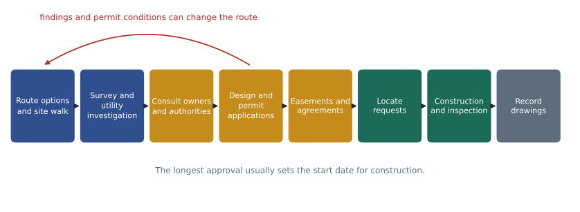
The site survey
A route on a site plan is a guess until someone has walked it. The designer walks every candidate route with the drawings, noting surface conditions, obstacles, existing structures, manhole and valve covers, signs of buried utilities such as pedestals, meters and patched pavement, trees whose roots will be disturbed, and places where equipment can and cannot work. Photographs and notes go into the project file. A professional land survey then fixes property lines, elevations and the locations of visible features, so that the design can be drawn on accurate base mapping.
Finding what is underground
The most dangerous assumption in outside plant work is that the utility records are right. Records are often old, incomplete or drawn to schematic accuracy only. A cable shown along the edge of a parking lot may have been moved twenty years ago, and private lines installed by a previous owner may not be on any record at all. Damage to buried gas, power or water lines can injure people and cost far more than the project.
Utility investigation is commonly described in levels of quality, so that everyone knows how much to trust each line on a drawing. In Canada, CSA S250 sets out how underground utility information is collected and mapped, with accuracy levels that describe how a utility's location was found. The lowest levels come from records or a visual survey of surface features; higher levels come from detecting utilities with electronic locating equipment and ground-penetrating radar; the highest comes from exposing the utility by careful digging, often with vacuum excavation, and measuring it directly.
| Level of information | How the location is found | How far to trust it |
|---|---|---|
| Records | Utility maps and old drawings | Least; useful for planning only |
| Surface features | Survey of covers, pedestals, meters and markings | Better; still approximate between features |
| Detected | Electronic locating and ground-penetrating radar | Good horizontal position; depth less certain |
| Exposed | Vacuum excavation or careful hand digging to see and measure the utility | Highest; at the point exposed |
Higher levels cost more, so the designer chooses where they are worth it: at crossings, where the bore or trench will pass close to existing lines, and anywhere a conflict would be costly. For the Harbourview street crossing, the design team pays for detection along the whole route and for vacuum excavation of the gas main and water main where the bore will pass beneath them. One test hole finds the water main 0.6 m shallower than the city's record, and the bore profile is lowered.
Locate requests
Before anyone digs, the excavator must request locates through the provincial or state one-call system. The one-call centre notifies every member utility with lines near the dig site, and each one marks its lines on the ground with paint or flags in a standard colour code. Locates show where member utilities believe their lines are; they do not show private lines that the property owner installed, such as parking lot lighting circuits or irrigation piping, which need a private locator.
In Ontario, the one-call system is run by Ontario One Call, now operating as Ontario Dig Authority, under the Ontario Underground Infrastructure Notification System Act. The excavator must request locates before digging; for a single-address project, the request should be made at least five business days ahead, and infrastructure owners have five business days to respond, while large or multi-address projects are submitted as advanced requests with up to ten business days. Digging may not start until every notified owner has responded.
Worked problem
Scheduling locates
The duct bank contractor plans to start digging on the morning of Monday, June 7, at a single address. No holidays fall in the two weeks before. If owners need five full business days after the day of the request, what is the latest day to make the request?
Show solution
- Counting back five full business days before Monday, June 7: Friday June 4, Thursday June 3, Wednesday June 2, Tuesday June 1 and Monday May 31.
- The request day itself does not count, so the request must be made on Friday, May 28 at the latest.
- Large projects need more time, and a wise contractor requests early in case marks are incomplete.
Answer: Friday, May 28 at the latest. Many contractors request a week earlier so that any missed marks can be fixed before the crew arrives.
Once marks are in place, the excavator must dig with care inside a tolerance zone on each side of a marked line, using hand digging or vacuum excavation to expose the utility before machines dig nearby. The width of the zone and the life of a locate ticket are set by the law and the one-call rules. The ICT designer's specification should require the contractor to follow them, to keep locate tickets current through the job and to stop work if unmarked utilities are found.
Permits and approvals
Many authorities may need to approve an outside plant project, depending on where the route goes and what it crosses.
| Authority | What it approves | Typical requirements |
|---|---|---|
| Municipality or road authority | Work in the public right-of-way, such as streets and sidewalks | Permit, traffic control plan, depth and location rules, restoration standard, security or bond |
| Property owners | Work on private or other public land | Easement, licence or agreement; restoration; insurance |
| Utility owners | Crossings near or attachments to their facilities | Crossing approval, separation, inspection, attachment agreement |
| Railway | Crossings under or over rail lines | Crossing agreement, engineering review, flagging, insurance |
| Environmental agency | Work near water, wetlands or protected areas | Erosion and sediment control, timing windows, permits |
| Building authority | Work on and in buildings, including entrances | Building and electrical permits and inspections |
Each authority has its own timeline, and the longest one sets the schedule. Road permits may take weeks, railway agreements months. The designer should identify every authority during route planning, ask each about its process and timeline, and put the applications on the project schedule before design is finished. Permit conditions often change the design: a road authority may require a deeper bore, a different crossing location or work only at night.
Easements and rights-of-way
A right-of-way is a strip of land that someone has the right to use for a purpose, such as a road or a utility line. An easement is the legal right that creates it on land owned by someone else. Campus duct banks that cross land owned by others, such as Harbourview's route across the city's parking lot, need an easement or a licence from the landowner, describing where the duct bank may go, what the owner of the duct bank may do, who maintains it and what happens if the land is sold or redeveloped. Easements are legal documents prepared by lawyers and surveyors, and they are registered on the land title so that future owners are bound by them.
Two points matter for the ICT designer. First, the route on the drawings must match the easement exactly, or the cable owner may end up with plant outside its rights. Second, the easement must allow access for future maintenance, cable pulling and replacement, not just initial construction. Daniel works with the college's lawyer to describe a 3 m wide easement centred on the duct bank, with rights to enter, to open the maintenance hole and to repair the paving afterward.
Construction requirements
Permits and easements usually come with conditions that the specification must pass on to the contractor: traffic control and pedestrian detours, working hours, protection of trees and landscaping, erosion and sediment control, dust and noise limits, restoration of paving, curbs and grass to a defined standard, and inspection hold points where the authority must see the work before it is covered. The designer should list every condition in the specification and on the drawings, because a missed condition can stop the job.
Record drawings and asset data
When the work is done, the designer or contractor prepares record drawings showing what was actually built: duct bank routes with survey coordinates and depths, structure locations and sizes, duct assignments, cable identifiers and splice locations. Many owners now keep this information in a geographic information system, so that future designers and locators can find it. The records also go to the one-call system if the owner registers its plant, so that future excavators are warned. Without accurate records, the owner's own cable becomes one of the unknown utilities that the next project has to find the hard way.
Worked problem
A permit timeline
The Harbourview team lists its approvals: city right-of-way permit, 10 weeks; easement across the city parking lot, 8 weeks, which can run at the same time as the permit; transit authority notice, 2 weeks, which can only start after the permit is issued; and locates, one week before digging. If all applications go in on the same day, how many weeks after the applications can digging start?
Show solution
- The permit and easement run in parallel; the longer is 10 weeks.
- The transit notice follows the permit: 10 + 2 = 12 weeks.
- Locates can be requested during the transit notice period, so they add nothing if timed well.
Answer: About 12 weeks. The permit is the critical item, which is why the team applied as soon as the route was fixed.
Bringing it together
By the time the duct bank goes in, the Harbourview design includes a survey, a utility investigation with exposed crossings, a city permit with eleven conditions, an easement across the parking lot, a railway check that found no railway, and a locate plan. Daniel keeps a single table listing every approval, its condition and its status, and reviews it at each site meeting. Roz tells him that on the RCDD exam, questions about outside plant often test exactly this: knowing who must approve what, and in what order.
When something goes wrong
Even with locates and careful digging, crews sometimes find utilities that were not marked or damage lines that were. The specification should tell the contractor what to do: stop work, protect the area, call the utility owner and, for gas or power, call emergency services and move people away. Damage to a buried line must usually be reported to its owner and, in many places, to the one-call system or regulator. The ICT designer's records help here too: when the owner's own cables are damaged by someone else, accurate locations and good locate registration make it far easier to recover repair costs.
Common mistakes
MistakeTrusting utility records without investigation.
InsteadDetect utilities along the route and expose them at crossings and close approaches.
MistakeAssuming the one-call locate shows everything.
InsteadPrivate lines installed by property owners need a private locator.
MistakeDrawing a route across land without an easement.
InsteadConfirm ownership and obtain easements or licences that match the route and allow future access.
MistakeLeaving permit conditions out of the specification.
InsteadList every condition so the contractor prices and follows it.
Summary and key terms
- Walk and survey every route; record surface features and signs of buried utilities.
- Utility information has levels of reliability, from records to exposed utilities; invest in higher levels at crossings.
- Excavators must request locates through the one-call system within the required notice period and dig carefully near marks; private lines need private locates.
- Permits may be needed from road, utility, railway, environmental and building authorities; the longest sets the schedule.
- Easements give the legal right to build and maintain plant on others' land and must match the route.
- Record drawings and asset data protect the owner's plant for future projects.
- Right-of-way
- A strip of land used for a road or utility under a legal right.
- Easement
- A registered legal right to use part of someone else's land for a defined purpose.
- One-call system
- The service that notifies utility owners of planned excavation so they can mark their lines.
- Locate
- The marking of buried utility lines on the ground by their owners.
- Tolerance zone
- The area on each side of a marked line where only careful hand or vacuum digging is allowed.
- Vacuum excavation
- Digging with high-pressure air or water and a vacuum to expose buried utilities safely.
Practice problems
Work each problem on paper first, then reveal the answer to check.
Why are private lines not shown by a one-call locate?
Show answer
One-call members locate their own lines; lines installed by property owners are not theirs.
Name three authorities that may need to approve a campus duct bank crossing a street.
Show answer
The road authority, utility owners near the route and the landowners crossed; possibly environmental agencies.
What two things must an easement allow besides construction?
Show answer
Access for maintenance and the right to pull, repair or replace cables.
Lesson quiz · 5 questions
Score 60% or more to complete this lesson.
Create a free account to save your progress, take quizzes and earn a certificate.