
GEOM-300 · Lesson 10 of 12 · 21 min
GNSS networks and services
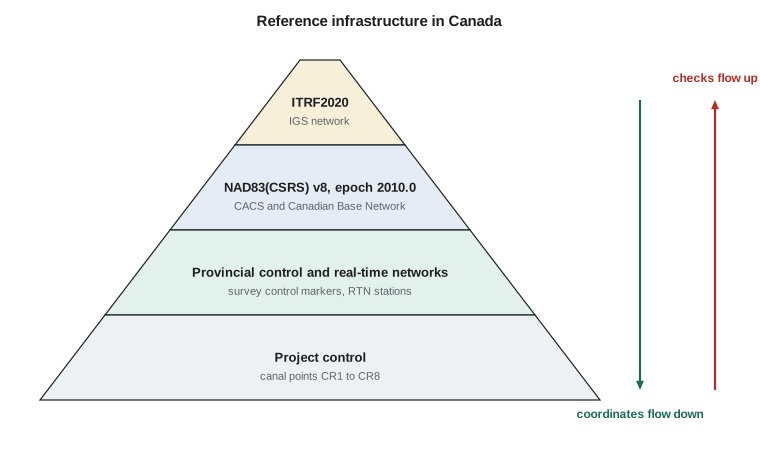
When the irrigation district's engineer asked how she could be sure that the canal control matched the coordinates used by the province, the neighbouring municipality and the pipeline company, Ruth Albrecht drew a pyramid on the whiteboard. At the top was the International Terrestrial Reference Frame and the global IGS network. Below it came the Canadian Spatial Reference System, realized by NRCan's active stations and the national high-precision network of pillars. Below that were the provincial survey control markers and real-time networks, and at the bottom the canal's own control points. \"Every coordinate we deliver,\" she said, \"is connected up the pyramid by measurements that anyone can repeat.\" This lesson describes that infrastructure and the services that make it usable.
Continuously operating reference stations
The modern geodetic frame is realized mainly by continuously operating reference stations (CORS): geodetic receivers on stable monuments, such as deep-braced steel masts or concrete pillars on bedrock, recording all signals around the clock and delivering data to archives. Their coordinates are estimated from years of data, so their positions and velocities are known to a millimetre or better. A user with a receiver of their own can position a new point by processing simultaneous observations with one or more CORS, or by PPP with products derived from the global network, and obtain coordinates consistent with the national frame without ever visiting a passive mark.
At the global level, the IGS network of several hundred stations on every continent supplies the data for precise orbits and clocks and, together with VLBI, satellite laser ranging and DORIS, defines the ITRF. National agencies operate or coordinate denser networks and compute the national frame from them, with stations whose coordinates are published in both the national frame and the ITRF.
In Canada, the Canadian Geodetic Survey of NRCan operates the Canadian Active Control System (CACS), a network of continuously operating stations across the country, and integrates data from provincial, academic and private stations. NAD83(CSRS) is realized through these stations and the Canadian Base Network, a network of forced-centring pillars observed by repeated GNSS campaigns. Version 8 of NAD83(CSRS), adopted in 2024 and based on ITRF2020, is the current realization at the reference epoch 2010.0. The Canadian Geodetic Reference System Committee coordinates federal and provincial agencies so that provincial realizations, such as Alberta's network of survey control markers, stay consistent with the national frame. Station coordinates, velocities and RINEX data are available through NRCan's online tools.
Passive control
Before CORS, national frames were realized by passive marks: brass disks and rods, observed occasionally by campaigns. They remain essential, because most users still need a physical point on the ground, and many legal and engineering records refer to them. But a passive mark can be disturbed or destroyed, its published coordinates may come from an old adjustment, and it moves with the ground between observations. Modern practice treats the active network as the primary realization and passive marks as a densification that must be checked, not trusted blindly.
Online processing services
NRCan's CSRS-PPP service, described in Lesson 9, is the main online processing tool for Canadian users and returns NAD83(CSRS) coordinates directly at a chosen epoch. Because PPP needs no nearby station, it gives consistent results anywhere in the country, including the remote north where stations are hundreds of kilometres apart. For projects that need relative accuracy at the millimetre level between nearby points, or real-time work, surveyors combine CSRS-PPP control with baselines processed to nearby active stations or with RTK from a network aligned to NAD83(CSRS).
Whatever service is used, its report contains the quality indicators that a surveyor must check: the percentage of observations used, the percentage of ambiguities fixed, the uncertainties or peak-to-peak spread between the reference stations used, and any warnings about antennas, data gaps or the session length. A good report on a short session can still be wrong if the antenna height was mistaken, so independent repeat sessions remain the real check.
Combining repeated sessions
For control points, one session is never enough. The canal's new points CR3 to CR8 were each observed in at least two sessions on different days, and some in more. The program below combines four sessions on CR3 by weighted mean, using the uncertainties reported by the service as weights, and computes residuals, peak-to-peak differences and a chi-square statistic for each component. It then applies the firm's screening rules for minimum session length and agreement between sessions.
# Combining repeated online-service solutions for new control point CR3
import math

SERVICE = "CSRS-PPP"
# Session: (hours, east, north, up in m relative to a nominal value, sigma E, N, U in m as reported)
sessions = [
    ("day 301", 6.1, 0.0123, 0.0071, 0.0310, 0.0040, 0.0045, 0.0110),
    ("day 302", 5.4, 0.0098, 0.0089, 0.0402, 0.0045, 0.0050, 0.0125),
    ("day 305", 8.2, 0.0111, 0.0062, 0.0275, 0.0032, 0.0036, 0.0090),
    ("day 306", 2.3, 0.0164, 0.0021, 0.0620, 0.0085, 0.0095, 0.0230),
]
print("Combining", len(sessions), SERVICE, "sessions")
names = ("east", "north", "up")
for k in range(3):
    vals = [s[2 + k] for s in sessions]; sig = [s[5 + k] for s in sessions]
    w = [1 / x ** 2 for x in sig]
    mean = sum(a * b for a, b in zip(w, vals)) / sum(w)
    s_mean = math.sqrt(1 / sum(w))
    resid = [v - mean for v in vals]
    chi2 = sum((r / x) ** 2 for r, x in zip(resid, sig))
    spread = max(vals) - min(vals)
    print(names[k].ljust(5), "weighted mean", format(1000 * mean, "6.1f"), "mm +/-", format(1000 * s_mean, "4.1f"),
          "mm  peak-to-peak", format(1000 * spread, "5.1f"), "mm  chi-square", format(chi2, "4.2f"), "with", len(vals) - 1, "dof")
    print("      residuals (mm):", ", ".join(format(1000 * r, "+.1f") for r in resid))

# Screening rules used by Coulee Geomatics for control from online services
rules = {"minimum session (h)": 4.0, "peak-to-peak horizontal (mm)": 20.0, "peak-to-peak vertical (mm)": 40.0}
short = [s[0] for s in sessions if s[1] < rules["minimum session (h)"]]
print("sessions shorter than the minimum:", short if short else "none")
pp_h = max(math.hypot(a[2] - b[2], a[3] - b[3]) for a in sessions for b in sessions)
pp_v = max(abs(a[4] - b[4]) for a in sessions for b in sessions)
print("largest horizontal difference between sessions", round(1000 * pp_h, 1), "mm; vertical", round(1000 * pp_v, 1), "mm")Combining 4 CSRS-PPP sessions
east weighted mean 11.5 mm +/- 2.1 mm peak-to-peak 6.6 mm chi-square 0.53 with 3 dof
residuals (mm): +0.8, -1.7, -0.4, +4.9
north weighted mean 6.8 mm +/- 2.4 mm peak-to-peak 6.8 mm chi-square 0.45 with 3 dof
residuals (mm): +0.3, +2.1, -0.6, -4.7
up weighted mean 33.6 mm +/- 5.9 mm peak-to-peak 34.5 mm chi-square 2.32 with 3 dof
residuals (mm): -2.6, +6.6, -6.1, +28.4
sessions shorter than the minimum: ['day 306']
largest horizontal difference between sessions 9.5 mm; vertical 34.5 mmHorizontally the four sessions agree within 7 mm and the chi-square values are small, which suggests the reported uncertainties are, if anything, a little pessimistic. Vertically the spread is 34.5 mm, and almost all of it comes from the 2.3-hour session on day 306, whose up component is 28 mm above the weighted mean. That session is also shorter than the firm's 4-hour minimum. Its reported uncertainty is large, so the weighted mean is barely affected, but the screening rules flag both its length and the vertical spread. The sensible course is to drop it, observe another long session, and recombine.
Worked problem
A weighted mean of heights
Using the up components and reported standard deviations of the four sessions on CR3, 31.0 ± 11.0, 40.2 ± 12.5, 27.5 ± 9.0 and 62.0 ± 23.0 mm relative to a nominal value, compute the weighted mean, its standard deviation and the standardized residual of the last session.
Show solution
- \[w_i = 1/\sigma_i^2: \quad 0.008\,26,\; 0.006\,40,\; 0.012\,35,\; 0.001\,89\ \text{mm}^{-2}\]
- \[\bar{u} = \frac{\sum w_i u_i}{\sum w_i} = \frac{0.2562 + 0.2573 + 0.3395 + 0.1172}{0.028\,90} = \frac{0.9702}{0.028\,90} = 33.6\ \text{mm}\]
- \[\sigma_{\bar{u}} = \frac{1}{\sqrt{0.028\,90}} = 5.9\ \text{mm}\]
- \[\frac{62.0 - 33.6}{23.0} = 1.24\]
Answer: The weighted mean is 33.6 ± 5.9 mm. The day-306 session differs from it by only 1.24 of its own standard deviations, so it is not a statistical outlier; it is simply a weak session. Statistical tests and professional rules answer different questions: the first asks whether the data are consistent with their stated precision, the second whether they meet the standard required for control.
Network adjustment
Baselines between project points and active stations, or between the project points themselves, are normally combined in a least-squares network adjustment, using the methods of GEOM-220. The baseline vectors and their covariance matrices are the observations. A minimally constrained adjustment, holding one point fixed, tests the internal consistency of the network: loop misclosures, residuals and the variance factor reveal blunders such as wrong antenna heights or mislabelled points. A constrained adjustment then holds the coordinates of the active stations or high-order control, in the national frame at the project's epoch, and distributes the network onto them. Large changes between the minimally constrained and constrained results indicate a problem with the control, not the new observations. The adjustment report, with the frame, epoch, control held, and statistics, becomes part of the project record.
Real-time networks as infrastructure
Real-time networks, described in Lesson 8, are now part of the reference infrastructure in their own right. Their stations are often CORS that also deliver data to national archives, and the quality of network RTK depends on how well the network is aligned to the national frame and kept aligned as stations are replaced, antennas changed and the ground moves. Users should know which frame and epoch the network uses, how its coordinates were determined and when they were last checked, and should check network results on independent control at the start of every project.
Choosing a strategy for project control
The infrastructure gives a surveyor several ways to put a project on the national frame, and the choice depends on the accuracy needed, the distances involved, the time available and how the control will be used. For the canal, Ruth combined three of them: long static sessions processed by an online service to place the main control on the national frame, static baselines between neighbouring control points adjusted as a network to give the millimetre-level relative accuracy the hydraulic design needed, and network RTK for the construction work, checked every day on the adjusted control. The table summarizes typical performance; actual results depend on conditions, equipment and procedure.
| Method | Typical session | Typical accuracy (95 %) | Best use |
|---|---|---|---|
| Online PPP or CORS-based service | 2–24 h static | about 1–2 cm horizontal, 2–4 cm vertical for several hours; mm for a day | primary control far from other control |
| Static baselines and network adjustment | 1–4 h per session | a few mm + 0.5–1 ppm relative | high-precision relative networks, deformation |
| Rapid static | 10–30 min | about 1 cm + 1 ppm on short baselines | densification near good control |
| Single-base RTK | seconds to minutes | about 2–3 cm H, 3–5 cm V near the base | staking, topography, local control checks |
| Network RTK | seconds to minutes | about 2–3 cm H, 3–5 cm V across the network | large projects inside network coverage |
| Code DGNSS or SBAS | seconds | 0.3–2 m | mapping, navigation to marks |
Whatever the mix, the control must be internally consistent and tied to the same frame and epoch at every level. A common failure is a project whose primary control came from a PPP service at the reference epoch, while its RTK work used a network whose coordinates were at a different epoch or realization; the resulting offsets of one or two centimetres appear as unexplained misclosures when conventional surveys connect the two.
Metadata and archiving
An observation file without accurate metadata is nearly worthless for precise work. For every session, the record should include the receiver and antenna types and serial numbers, the antenna height and how it was measured, the mark description, the start and end times, the person responsible and photographs of the setup. For permanent stations, a site log records every change of equipment, because each antenna change can introduce a small jump in the coordinate time series. Delivering control to a client includes delivering the raw data in RINEX, the processing reports and these records, so that the work can be checked and reused.
Common mistakes
MistakeUsing a passive mark's published coordinates without checking.
InsteadCheck passive marks against the active network; they may be disturbed or from an older adjustment.
MistakeAccepting one online-service session as final control.
InsteadObserve at least two independent sessions on different days and compare.
MistakeIgnoring service report indicators.
InsteadCheck observations used, ambiguities fixed, peak-to-peak spread and warnings.
MistakeConstraining an adjustment before testing it.
InsteadRun a minimally constrained adjustment first to find blunders in the new observations.
MistakeDelivering coordinates without frame, epoch and data.
InsteadDeliver RINEX, reports, metadata and a statement of frame, realization and epoch.
Summary and key terms
- Reference infrastructure forms a hierarchy from the ITRF and IGS network to national, regional and project control.
- Continuously operating reference stations realize modern frames with positions and velocities known to a millimetre.
- In Canada, NAD83(CSRS) v8 at epoch 2010.0 is realized by CACS, the Canadian Base Network and provincial networks.
- CSRS-PPP returns NAD83(CSRS) coordinates directly; baselines and RTK from aligned networks add relative accuracy.
- Repeated sessions are combined by weighted means and screened with statistical and professional criteria.
- Network adjustments are first minimally constrained, then constrained to control in the right frame and epoch.
- Metadata, raw data and reports make control verifiable and reusable.
- CORS
- Continuously operating reference station: a permanent GNSS station recording data continuously.
- Active control
- A geodetic frame realized by continuously operating stations rather than passive marks.
- Passive mark
- A physical survey monument whose coordinates are determined by occasional observation campaigns.
- Minimally constrained adjustment
- A network adjustment with only enough constraints to define the datum, used to test internal consistency.
- Peak-to-peak
- The range between the largest and smallest of several solutions for the same coordinate.
- Site log
- A record of equipment and changes at a permanent GNSS station.
Practice problems
Work each problem on paper first, then reveal the answer to check.
Two sessions give heights 912.604 ± 0.010 and 912.632 ± 0.010 m. What is the weighted mean?
Show answer
912.618 m, with σ = 0.007 m; the 28 mm difference is 2 σ of the difference and deserves a third session.
Why are CORS coordinates published with velocities?
Show answer
The stations move with the plate and local deformation; velocities let coordinates be computed at any epoch.
What does a minimally constrained adjustment test?
Show answer
The internal consistency of the new observations, independent of control errors.
An antenna is replaced at a CORS. What should be recorded?
Show answer
The change in the site log, with date, models and heights, because a coordinate jump may follow.
What should accompany delivered control coordinates?
Show answer
Frame, realization and epoch, RINEX data, processing reports and metadata.
Lesson quiz · 5 questions
Score 60% or more to complete this lesson.
Create a free account to save your progress, take quizzes and earn a certificate.