
GEOM-300 · Lesson 1 of 12 · 25 min
GNSS constellations
Coulee Geomatics had won the control survey for a new irrigation canal running west from Coulee Ridge toward the foothills, and Ruth Albrecht wanted every new control point positioned by satellite before the levelling crews went out. Leah Tran, now in her second year with the firm, opened the planning software for the first morning of observations and counted the satellites it predicted above the 10° mask at pillar CR1: eleven GPS, seven GLONASS, nine Galileo and eight BeiDou, thirty-five in all. \"Twenty years ago you would have had eight,\" Ruth said. \"And you would have planned the whole week around the two hours when the geometry was good.\" This course is about what has changed, why positioning by satellite works, what limits its accuracy, and how surveyors and engineers turn signals from space into coordinates they can defend. It starts with the satellites themselves.
What a GNSS is
A global navigation satellite system (GNSS) is a constellation of satellites that broadcast radio signals carrying precise timing and their own predicted positions, together with the ground infrastructure that keeps those predictions and clocks accurate. A receiver that measures the travel time of signals from at least four satellites can solve for its three-dimensional position and the error of its own clock. Nothing is transmitted from the user, so an unlimited number of receivers can use the system at once, passively and anonymously. That one design decision, made for military navigation in the 1970s, is why satellite positioning is now in every phone, tractor, aircraft and survey rover.
Every GNSS has the same three parts. The space segment is the constellation: the satellites, their orbits and the signals they transmit. The control segment is the network of monitoring stations, master control stations and uplink antennas that track the satellites, estimate their orbits and clock errors, and upload fresh navigation messages. The user segment is every receiver, from a single-frequency chip in a watch to a geodetic receiver tracking every signal from every system. When surveyors speak of the accuracy of GNSS, they are speaking about the combined performance of all three, and about what the user does with the measurements.
GPS
The NAVSTAR Global Positioning System of the United States is the oldest of the global systems and the reference against which the others are usually compared. The first prototype satellite was launched in 1978, the system was declared fully operational in 1995, and the deliberate degradation of civil accuracy called selective availability was switched off in May 2000, which improved stand-alone civil accuracy from about 100 m to a few metres overnight. GPS is operated by the United States Space Force, with civil requirements represented through other federal agencies.
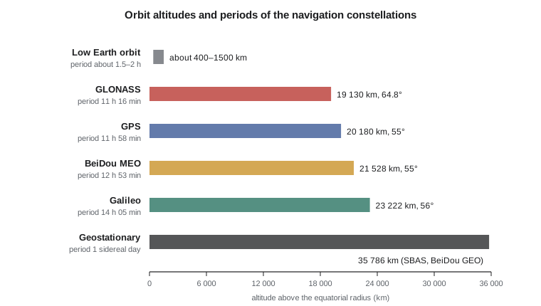
The nominal design is 24 satellites in six orbital planes inclined at 55°, at an altitude of about 20,180 km, but the operational constellation has held about 31 satellites for many years so that spare satellites fill gaps and improve geometry. The satellites belong to several generations, called blocks. Block IIR satellites carry only the legacy civil signal L1 C/A plus military codes; IIR-M added the civil L2C signal; IIF added the safety-of-life L5 signal; and GPS III, whose ten satellites were all launched by 2026, adds the modern L1C signal shared with other systems, higher power and better clocks. A further block, GPS IIIF, is in development. Because the blocks coexist, a receiver sees a mix of signals and the number of satellites broadcasting L5 or L1C is still smaller than the total.
GPS positions are expressed in WGS 84, a frame maintained by the United States National Geospatial-Intelligence Agency and aligned with the ITRF at the level of a centimetre or so. GPS time is a continuous atomic time scale that started at midnight between 5 and 6 January 1980 and does not include leap seconds; it is currently 18 s ahead of UTC.
GLONASS
GLONASS, the Russian system, was developed in parallel with GPS and reached a full constellation in 1995, then declined in the economic crisis that followed and was restored to 24 satellites by 2011. Its satellites orbit in three planes inclined at 64.8°, at about 19,130 km. The higher inclination gives better coverage at high latitudes, which matters for Russia and is useful at northern latitudes generally: on the prairies, GLONASS satellites often fill the northern part of the sky where GPS satellites rarely pass.
The legacy GLONASS signals use frequency division multiple access (FDMA): every satellite transmits the same code on a slightly different carrier frequency, from a set of channels around 1602 MHz and 1246 MHz. This makes GLONASS harder to combine with the other systems in carrier-phase processing, because receiver hardware delays differ slightly from channel to channel and these inter-frequency biases do not cancel completely between different receiver brands. Newer GLONASS-K satellites also transmit code division multiple access (CDMA) signals like the other systems. GLONASS uses its own frame, PZ-90.11, which agrees with the ITRF at the centimetre level, and its own time scale tied to UTC as kept in Russia, including leap seconds.
Galileo
Galileo is the civil global system of the European Union, managed by the EU Agency for the Space Programme with the European Space Agency as design and procurement agent. Its satellites orbit in three planes inclined at 56°, at about 23,222 km, so their period is just over 14 h. Initial services were declared in December 2016. The constellation was strengthened by further launches, including two satellites carried by an Ariane 6 rocket in December 2025, and second-generation satellites are being built. Galileo was designed from the start for civil users, with modern signals on E1, E5a, E5b and E6, very stable hydrogen maser clocks, and services that the older systems do not offer.
Two of those services matter to surveyors. The High Accuracy Service broadcasts free precise orbit and clock corrections on the E6 signal and through the internet, aimed at about 20 cm horizontal accuracy after convergence; its initial service began in January 2023. Open Service Navigation Message Authentication (OSNMA) adds cryptographic signatures to the navigation message on E1 so that a receiver can confirm that the data came from Galileo and not from a spoofer; it was declared operational in July 2025. Lesson 12 returns to why authentication matters. Galileo positions are in the Galileo Terrestrial Reference Frame, also aligned with the ITRF, and Galileo System Time is steered to GPS time with a broadcast offset of a few nanoseconds.
BeiDou
China's BeiDou Navigation Satellite System grew in three stages: an experimental regional system from 2000, a regional system over Asia and the Pacific in 2012, and the global BDS-3 constellation completed in 2020. BDS-3 is unusual in mixing three orbit types. Its core is 24 medium Earth orbit satellites in three planes at about 21,528 km and 55°, supplemented by satellites in geostationary orbit and in inclined geosynchronous orbits, which trace a figure eight north and south of the equator over Asia. From North America the geostationary and inclined geosynchronous satellites are mostly below the horizon, so users here track the MEO satellites. BeiDou broadcasts the open signals B1I, B1C, B2a and B2b and uses its own frame and time scale; BeiDou time is 14 s behind GPS time because it started in 2006 without the leap seconds that had accumulated since 1980.
Regional systems and augmentation
Two regional systems complement the global ones. Japan's Quasi-Zenith Satellite System (QZSS) places satellites in highly inclined geosynchronous orbits so that one is always near the zenith over Japan, which helps in deep urban canyons; it broadcasts GPS-compatible signals and a centimetre-level correction service for Japan. India's NavIC covers India and the surrounding region. Neither is usable in Alberta or Montana for positioning, but their satellites can appear in sky plots and in data files, and good processing software knows to exclude them where they do not help.
Satellite-based augmentation systems (SBAS) are not navigation systems in their own right. They broadcast corrections and integrity information from geostationary satellites on the GPS L1 frequency, so ordinary receivers can use them. The Wide Area Augmentation System (WAAS) of the United States Federal Aviation Administration covers North America, including most of Canada; EGNOS covers Europe, and similar systems serve Japan, India and other regions. SBAS was built for aviation, where the main requirement is not centimetres but a guarantee that the position error is bounded, and Lesson 6 describes how it works.
Canada does not operate its own navigation constellation. It relies on the global systems, uses WAAS for aviation through agreements with the United States, and invests instead in the reference infrastructure that turns GNSS into accurate coordinates: the Canadian Active Control System of continuously operating stations and the free CSRS-PPP online processing service of Natural Resources Canada, both covered in Lessons 9 and 10.
| System | Operator | Orbit altitude | Inclination | Planes | Civil signals (main) |
|---|---|---|---|---|---|
| GPS | United States | 20 180 km | 55° | 6 | L1 C/A, L1C, L2C, L5 |
| GLONASS | Russia | 19 130 km | 64.8° | 3 | L1OF, L2OF (FDMA); L3OC (CDMA) |
| Galileo | European Union | 23 222 km | 56° | 3 | E1, E5a, E5b, E6 |
| BeiDou (BDS-3) | China | 21 528 km (MEO) | 55° | 3 (MEO) plus GEO and IGSO | B1I, B1C, B2a, B2b |
| QZSS | Japan | geosynchronous | about 40° | regional | L1 C/A, L1C, L2C, L5, L6 |
| NavIC | India | geosynchronous | 0° and 29° | regional | L5, S |
Orbits, periods and repeating geometry
All four global systems chose medium Earth orbit (MEO), between about 19,000 and 23,000 km. A higher orbit sees more of the Earth from each satellite, so fewer satellites are needed for global coverage, but it requires more transmitter power for the same signal strength on the ground and more energy to launch. Low Earth orbit satellites, a few hundred to 1500 km up, need hundreds of satellites for continuous coverage; commercial LEO constellations are now being explored as a complement to GNSS for positioning and timing, with stronger signals that are harder to jam, but they are not yet a survey tool.
The orbital period follows from Kepler's third law. For a circular orbit of radius \(a\) around a body with gravitational constant \(GM\),
GPS satellites were placed so that their period is half a sidereal day. The ground track and the sky geometry seen from any site therefore repeat every sidereal day, which is about 3 min 56 s shorter than a solar day. A survey crew that had good satellite geometry at 10:00 yesterday will have the same GPS geometry at about 09:56 today. The other systems were chosen differently: GLONASS repeats after 8 sidereal days, Galileo after 10 and the BeiDou MEO satellites after 7. The repetition of GPS geometry is useful in the analysis of multipath, which repeats with the geometry, and it is one reason why multi-GNSS observations are statistically stronger than GPS alone: errors that would repeat from day to day with GPS are mixed by the other systems.
Worked problem
Period of a GPS orbit
A GPS satellite orbits at an altitude of 20,180 km above the equatorial radius of 6,378.137 km. With \(GM = 3.986\,004\,418 \times 10^{14}\ \text{m}^3/\text{s}^2\), find its period, compare it with a sidereal day of 86,164.09 s, and find its orbital speed.
Show solution
- \[a = 6\,378\,137 + 20\,180\,000 = 26\,558\,137\ \text{m}\]
- \[T = 2\pi\sqrt{\frac{(2.655\,814 \times 10^{7})^3}{3.986\,004 \times 10^{14}}} = 2\pi\sqrt{1.873\,26 \times 10^{9}}\ \text{s} = 43\,076\ \text{s}\]
- \[\frac{T}{86\,164.09\ \text{s}} = 0.4999\]
- \[v = \sqrt{\frac{GM}{a}} = \sqrt{\frac{3.986\,004 \times 10^{14}}{2.655\,814 \times 10^{7}}} = 3874\ \text{m/s}\]
Answer: The period is 43,076 s, or 11 h 58 min, which is half a sidereal day to within the precision of the altitude used. The satellite moves at about 3.9 km/s, so its range to a user changes by up to several hundred metres every second; that rate of change is the Doppler shift a receiver must track.
The program below repeats the calculation for all four global systems, prints the daily shift of GPS geometry, computes the geostationary altitude from the same law, and estimates how much of the Earth's surface each satellite sees above a 10° elevation mask. Each MEO satellite covers about 30 % of the Earth, which is why about 24 well-placed satellites are enough for at least four to be visible everywhere at all times.
# Orbit size, period and ground-track repeat for the main GNSS constellations
import math

GM = 3.986004418e14        # Earth's gravitational constant, m^3/s^2
R_E = 6378137.0            # equatorial radius, m
SIDEREAL_DAY = 86164.0905  # seconds

systems = {  # name: (orbit altitude km, inclination deg, planes, satellites in the nominal design)
    "GPS":     (20180, 55.0, 6, 24),
    "GLONASS": (19130, 64.8, 3, 24),
    "Galileo": (23222, 56.0, 3, 24),
    "BeiDou":  (21528, 55.0, 3, 24),
}
print("system    radius km  period h  sidereal days  speed km/s")
for name, (alt, inc, planes, n) in systems.items():
    a = R_E + alt * 1000.0
    T = 2 * math.pi * math.sqrt(a ** 3 / GM)          # Kepler's third law
    v = math.sqrt(GM / a)                              # circular orbital speed
    print(name.ljust(9), format(a / 1000, "9.0f"), format(T / 3600, "9.3f"),
          format(T / SIDEREAL_DAY, "13.4f"), format(v / 1000, "11.2f"))

# A GPS satellite completes two orbits per sidereal day, so the same sky
# geometry repeats about 3 min 56 s earlier each solar day.
shift = 86400 - SIDEREAL_DAY
print("daily repeat shift for GPS:", round(shift / 60, 2), "minutes earlier")

# Geostationary radius: the orbit whose period equals one sidereal day
a_geo = (GM * (SIDEREAL_DAY / (2 * math.pi)) ** 2) ** (1 / 3)
print("geostationary altitude:", round((a_geo - R_E) / 1000), "km")

# How much of the Earth one MEO satellite sees above a 10 degree mask
for name, (alt, *_rest) in systems.items():
    r = (R_E + alt * 1000) / R_E
    el = math.radians(10)
    psi = math.acos(math.cos(el) / r) - el             # Earth central angle of the coverage circle
    frac = (1 - math.cos(psi)) / 2
print(name.ljust(9), "covers", format(100 * frac, ".1f"), "% of the Earth above 10 deg elevation")system radius km period h sidereal days speed km/s GPS 26558 11.965 0.4999 3.87 GLONASS 25508 11.262 0.4705 3.95 Galileo 29600 14.078 0.5882 3.67 BeiDou 27906 12.887 0.5384 3.78 daily repeat shift for GPS: 3.93 minutes earlier geostationary altitude: 35786 km GPS covers 29.9 % of the Earth above 10 deg elevation GLONASS covers 29.5 % of the Earth above 10 deg elevation Galileo covers 31.1 % of the Earth above 10 deg elevation BeiDou covers 30.5 % of the Earth above 10 deg elevation
Interoperability and multi-GNSS
The systems were designed separately, but they were brought closer together through international coordination, largely in the International Committee on GNSS under the United Nations. GPS L1C, Galileo E1, BeiDou B1C and QZSS L1C share the 1575.42 MHz centre frequency and similar modulations; GPS L5, Galileo E5a and BeiDou B2a share 1176.45 MHz. A receiver can therefore use the same antenna and front end for most signals, and dual-frequency combinations such as L1 and L5 work across systems. Lesson 2 explains these signals.
Using several systems at once is called multi-GNSS. Its benefits are more satellites, better geometry, more robustness when buildings, trees or terrain block parts of the sky, and faster ambiguity resolution in carrier-phase positioning. Its costs are that each system has its own time scale, its own frame, and its own biases between signals, which must be estimated or calibrated. Processing software usually handles time offsets by estimating one receiver clock parameter per system, or one clock and an inter-system bias for each additional system, which consumes one observation per system.
Ruth's first rule for planning is not to count satellites but to look at geometry and obstruction. In the coulees, steep valley walls block whole sectors of sky; along the river, cottonwoods attenuate signals in summer; near the grain elevators, metal surfaces reflect them. The planning software takes a terrain model and a list of obstructions and predicts the satellites visible and the dilution of precision, a measure of geometry that Lesson 4 defines. With thirty-five satellites predicted, Leah could choose a 10° mask, discard GLONASS on the receivers whose brands did not match at the base, and still expect good geometry all morning.
The control segment and system status
A constellation is only as good as its broadcast predictions. The GPS control segment, for example, uses monitoring stations around the world to track every satellite continuously, a master control station to estimate orbits and clocks, and ground antennas to upload new navigation messages, normally at least once a day and more often when needed. The broadcast orbit is a prediction a few hours old, and its error is typically a metre or less; the clock prediction error is similar. Lesson 3 shows how a receiver turns the broadcast parameters into a satellite position.
Each operator publishes notices to users about satellites being moved, tested or taken out of service, and about planned changes. A satellite flagged unhealthy in its navigation message should not be used, and good receivers exclude it automatically. Surveyors planning a precise campaign check the status pages, avoid times when a satellite is being manoeuvred, and keep the raw data so that unhealthy satellites can be excluded in processing if the receiver did not catch them.
Common mistakes
MistakeCounting satellites instead of checking geometry.
InsteadThirty satellites clustered in half the sky can give worse geometry than ten spread evenly; plan with predicted DOP and obstructions.
MistakeAssuming every satellite of a system broadcasts every signal.
InsteadSignal availability depends on the satellite block; only part of the GPS constellation broadcasts L5 and L1C.
MistakeMixing system times without an offset.
InsteadGPS, GLONASS, Galileo and BeiDou keep separate time scales; software must estimate or apply the inter-system offsets.
MistakeTreating SBAS as a navigation constellation.
InsteadSBAS broadcasts corrections and integrity for other systems; it adds ranging only from a few geostationary satellites.
MistakeForgetting that GPS geometry repeats about 4 min earlier each day.
InsteadPlan repeat sessions with the shift, or deliberately offset them to vary the geometry and the multipath.
Summary and key terms
- A GNSS has a space segment, a control segment and a passive user segment; at least four satellites give position and receiver clock error.
- GPS, GLONASS, Galileo and BeiDou all use medium Earth orbits between about 19 000 and 23 000 km.
- Kepler's third law gives the period: about 11 h 58 min for GPS, half a sidereal day, so GPS geometry repeats about 3 min 56 s earlier each day.
- GLONASS legacy signals use FDMA; the other systems and new GLONASS signals use CDMA.
- Galileo offers a free High Accuracy Service and navigation message authentication (OSNMA).
- BeiDou mixes MEO, geostationary and inclined geosynchronous satellites; from North America the MEO satellites dominate.
- Multi-GNSS improves availability, geometry and ambiguity resolution but requires handling of separate time scales, frames and biases.
- GNSS
- Global navigation satellite system: a constellation of satellites broadcasting ranging signals and navigation data, with its control infrastructure.
- Space segment
- The satellites of a GNSS, their orbits and the signals they transmit.
- Control segment
- The ground stations that track satellites, estimate their orbits and clocks, and upload navigation messages.
- Medium Earth orbit
- An orbit between low Earth orbit and geosynchronous altitude, used by all global navigation systems.
- Sidereal day
- The rotation period of the Earth relative to the stars, about 23 h 56 min 4 s.
- SBAS
- Satellite-based augmentation system: corrections and integrity data broadcast from geostationary satellites on a GNSS frequency.
Practice problems
Work each problem on paper first, then reveal the answer to check.
What is the period of a satellite at radius 29 600 km?
Show answer
T = 2π√(a³/GM) = 50 680 s, about 14 h 05 min, as for Galileo.
Good GPS geometry occurred at 13:20 on Monday. When does the same geometry recur on Thursday?
Show answer
Three days at about 3 min 56 s each: about 13:08.
Why can 24 MEO satellites provide global coverage?
Show answer
Each sees about 30 % of the Earth above a 10° mask, so with good spacing at least four are always visible.
What is the offset between BeiDou time and GPS time?
Show answer
BeiDou time is 14 s behind GPS time.
Name one advantage and one cost of multi-GNSS processing.
Show answer
Advantage: more satellites and better geometry. Cost: extra clock or inter-system bias parameters and frame and time offsets.
Lesson quiz · 5 questions
Score 60% or more to complete this lesson.
Create a free account to save your progress, take quizzes and earn a certificate.