
GEOM-410 · Lesson 6 of 12 · 20 min
Easements and rights of way
Most of the district's canals do not sit on land the district owns. They sit on rights of way: rights to build, operate and maintain a canal across someone else's land, granted or taken decades ago and held by the district ever since. The district's question for this project, whether it holds its canals securely, is really a question about easements. What rights does each instrument give, over what strip, for what purposes? Does it include the maintenance road beside the canal and the spoil banks? Has any of it been lost, moved or left behind when the canal was realigned? This lesson covers the law and the survey practice of easements and rights of way.
What an easement is
An easement is a right to use another person's land for a particular purpose, or to stop the owner from using it in a particular way. The land that bears the easement is the servient land; where the easement benefits other land, that land is the dominant land, and the easement is said to be appurtenant to it and passes with it on a sale. A classic example is a right of way across a neighbor's field to reach a public road. The owner of the servient land keeps the fee simple and may use the land in any way that does not interfere unreasonably with the easement. The easement holder may use the land only for the purpose and within the limits the easement allows.
US law recognizes both easements appurtenant, which benefit a parcel, and easements in gross, which benefit a person or company, such as a utility or an irrigation district, without any dominant land. Commercial easements in gross, including those for canals, pipelines and power lines, can generally be transferred. In much of the West, canal rights of way have a federal origin as well. Patents for public land west of the 100th meridian issued after the Act of August 30, 1890 generally reserve a right of way for ditches or canals constructed by the authority of the United States, and the Reclamation Service relied on that reservation, as well as on purchases and deeds, when it built projects such as the canals around Great Falls. A surveyor retracing a district canal must read the patent as well as later deeds.
How easements are created
Easements can be created in several ways. The most secure is an express grant: a written instrument, signed by the owner of the servient land, that describes the easement, its purpose and its location, often by reference to a plan. An easement may also be expressly reserved by an owner who sells part of their land and keeps a right over the part sold. Easements can arise by implication, when land is divided and the circumstances show that a right of use was intended, and by necessity, when a divided parcel would otherwise have no access at all. Some easements arise by statute, for example under a utility's or an irrigation district's powers.
Montana also recognizes easements by prescription: open, notorious, exclusive, adverse, continuous and uninterrupted use for the statutory period, which in Montana is five years. Prescription cannot generally run against land held by the United States. For the district, a canal reach that rests only on long use may be protected by prescription if it crosses private land, but the scope of a prescriptive easement is limited to the use actually made during the period, and proving it may need testimony and old photographs. The board will want written easements wherever it can get them.
Location, width and scope
The surveyor's main contribution to an easement is its location. Some instruments describe a strip precisely: so many meters or feet on each side of a centerline shown on a plan, with the centerline tied to section corners. Others describe it vaguely: a right of way for the canal as now constructed, or a strip sufficient for the ditch and its banks. A precise description is retraced like any other boundary. A vague one is located by the evidence of what was built and used when the easement was granted, because that is what the parties intended. In both cases the surveyor shows the strip on a plan, with its widths, its tie to the parcel boundaries, and its area within each parcel.
Width matters for more than area. The district needs room for the canal itself, the banks, the maintenance road and the spoil from cleaning. An easement for the canal may or may not include a road, and courts have sometimes held that an easement includes the secondary rights reasonably needed to maintain the primary one, such as access to clean the ditch, but not more. Scope also limits use: an easement granted for an irrigation canal may not allow the district to lay a fiber-optic cable or let the public walk the banks without the landowner's consent. Each instrument must be read for its own terms. Where an instrument is silent or ambiguous, courts look at the circumstances when it was granted: what the canal looked like, how it was maintained, and what both parties understood. That history is part of the surveyor's research, and photographs of the canal from the 1950s can be as useful as the instrument itself in showing how wide the working strip actually was.
Measuring Lateral 7
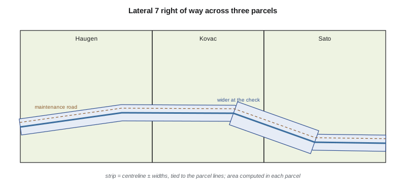
Lateral 7's right of way was granted in 1952 by instruments that refer to a plan showing a centerline and a strip 15 m on each side, widened to 20 m on each side for 330 m around a check structure. Theo computes the strip's length and area from the centerline Grant has retraced, and splits it among the three parcels it crosses.
import math
# Lateral 7 right of way: a strip described by an axis line and a width on each side (m)
axis = [(0.0, 0.0), (310.0, 42.0), (655.0, 41.0), (980.0, -38.0), (1290.0, -40.0)]
widths = [(15.0, 15.0), (15.0, 15.0), (20.0, 20.0), (15.0, 15.0)]   # (left, right) per segment; wider at the check
# Parcel boundaries crossed by the strip, as chainages along the axis (m)
parcels = [("Haugen", 0.0, 402.6), ("Kovac", 402.6, 870.0), ("Sato", 870.0, 1302.0)]

seg_len = [math.dist(a, b) for a, b in zip(axis, axis[1:])]
chain = [0.0]
for L in seg_len: chain.append(chain[-1] + L)
print("segment  length (m)  width (m)  area (m2)")
total = 0.0
for i, (L, (l, r)) in enumerate(zip(seg_len, widths)):
    total += L * (l + r)
    print(f"  {i+1}      {L:8.2f}    {l+r:5.1f}   {L*(l+r):9.1f}")
print(f"total length {chain[-1]:.2f} m, area about {total/10000:.4f} ha (bends not trimmed)")

def area_in(c1, c2):
    a = 0.0
    for i, (L, (l, r)) in enumerate(zip(seg_len, widths)):
        lo, hi = max(c1, chain[i]), min(c2, chain[i + 1])
        if hi > lo: a += (hi - lo) * (l + r)
    return a
print("parcel    chainage from-to (m)   right of way (ha)")
for name, c1, c2 in parcels:
    c2 = min(c2, chain[-1])
print(f"{name:8s} {c1:7.1f} - {c2:7.1f} {area_in(c1, c2)/10000:.4f}")segment length (m) width (m) area (m2) 1 312.83 30.0 9385.0 2 345.00 30.0 10350.0 3 334.46 40.0 13378.5 4 310.01 30.0 9300.2 total length 1302.30 m, area about 4.2414 ha (bends not trimmed) parcel chainage from-to (m) right of way (ha) Haugen 0.0 - 402.6 1.2078 Kovac 402.6 - 870.0 1.6144 Sato 870.0 - 1302.0 1.4183
The strip is about 1.30 km long and about 4.24 ha in area, of which about 1.21 ha crosses the Haugen parcel, 1.61 ha the Kovac parcel and 1.42 ha the Sato parcel. The areas are approximate, because the strip is not trimmed at the bends; a plan for registration or recording would compute each part exactly from the strip limits. What matters for the district is that the retraced centerline matches the canal as built: if the canal had been moved, the right of way would stay where the instrument put it, and the district would be operating part of the canal on land it has no right to use.
Worked problem
Strip area for a simple right of way
A pipeline right of way runs straight across a parcel for 640.0 m, with a width of 18.0 m. What area of the parcel does it occupy, in hectares and acres?
Show solution
- \[A = 640.0 \times 18.0 = 11\,520\ \text{m}^2\]
- \[11\,520\ \text{m}^2 = 1.152\ \text{ha} = 11\,520 / 4046.86 = 2.85\ \text{acres}\]
Answer: 1.152 ha, or about 2.85 acres.
Writing the description
A right of way the district wants to record needs a description that a title company and a court can follow. For a strip of defined width, that is usually a written description by courses and distances along a centerline, tied to a section or quarter corner, with the widths on each side stated and the side lines lengthened or shortened to end at the parcel boundaries, together with an exhibit drawing signed by a Montana Professional Land Surveyor. A certificate of survey can also show the strip. A description in words such as a strip 100 ft wide centered on the canal as now constructed is hard to retrace and invites dispute; a surveyed description removes the ambiguity, because it fixes the strip at the time it is granted. Theo's database stores each easement with its recording reference and its area by parcel, so the district can see at a glance which reaches are fully secured.
Encroachments and crossings
An easement also gives the district a duty to manage what happens inside it. Farmers want to cross canals with access roads, pipes and power lines; neighbors build sheds and fences close to the banks; utilities want to lay cables along the strip. The district handles these with crossing agreements, which set out where and how a crossing may be built, who maintains it and who pays if it damages the canal. Inside its strip, the district must also respect the landowner's remaining rights, because the land is still theirs. During the field work, Grant's crew records every structure within 10 m of each strip limit, so that the district's lawyer can sort encroachments that must be removed from crossings that only need a written agreement. Of the 41 structures recorded in the first season, most are small culverts and fences, three are sheds and one is part of a house deck, which is a conversation for the board, not the field crew.
When canals move
Canals do move. A reach is lined, realigned around a farmyard, or replaced with a pipeline, and the old ditch is filled in. Each change raises the question of whether the easement moved too. In general it does not move by itself: an easement fixed by an instrument stays where the instrument put it, and using a new location requires a new grant or an agreed relocation, properly documented. An easement is not lost simply because it is not used for a time, but it can be extinguished by a release, by merger when the same person comes to own both the easement and the land, by the expropriation or acquisition of the land, or, in some jurisdictions and circumstances, by clear abandonment. For the district, every reach where the canal has moved since its right of way was granted is a reach where the paper and the ground may not match.
Grant's crew finds three such reaches. On one, the canal was moved 40 m east in 1979 to clear a new farmyard, and the farmer signed a letter agreeing, but nothing was recorded. On another, a 1990s pipeline replaced the open ditch on the same line, within the deeded strip. On the third, the old right-of-way map shows the canal running through what is now a gravel pit. Ruth's report recommends a new recorded easement for the first reach, a confirmation for the second, and research into the third before anyone decides whether the district still holds a right there.
Common mistakes
MistakeAssuming an easement moves with the canal.
InsteadAn easement stays where its instrument put it unless properly relocated.
MistakeReading every right of way as including a maintenance road.
InsteadCheck the instrument; secondary rights are limited to what is reasonably needed.
MistakeTreating non-use as extinguishment.
InsteadNon-use alone usually does not end an easement; look for a release, merger or clear abandonment.
MistakeShowing an easement on a plan without ties to the parcel boundaries.
InsteadTie the strip to the boundaries and compute its area in each parcel.
Summary and key terms
- An easement is a right to use another's land for a purpose; the servient owner keeps the fee.
- US law allows easements in gross; many western canal rights of way rest on the 1890 patent reservation and on deeds.
- Easements arise by express grant or reservation, implication, necessity and statute; prescription depends on the jurisdiction.
- The surveyor locates the strip, ties it to parcel boundaries and computes its area in each parcel.
- Width and scope are limited by the instrument and by what is reasonably needed for its purpose.
- Easements do not move with relocated works; new locations need new instruments.
- Servient land
- The land that bears an easement.
- Dominant land
- The land an appurtenant easement benefits.
- Easement in gross
- An easement that benefits a person or company rather than a parcel.
- Utility right of way
- A statutory right of way for a utility, registrable without dominant land.
- Express grant
- A written instrument creating an easement.
- Prescription
- Creation of an easement by long adverse use, where the law allows it.
- Merger
- The ending of an easement when one person comes to own both the easement and the land.
Practice problems
Work each problem on paper first, then reveal the answer to check.
A strip 20 m wide runs 1.25 km. What is its area in hectares?
Show answer
20 × 1250 = 25,000 m² = 2.5 ha.
Why might a canal easement not allow a fiber-optic cable?
Show answer
The easement's scope is limited to its stated purpose.
The district moved a canal 40 m with only a letter of agreement. What is the risk?
Show answer
The registered or recorded right of way stays on the old line; the new line may not be secured.
How is a vague easement description such as 'the ditch as now constructed' located?
Show answer
By evidence of what was built and used when the easement was granted.
Name two ways an easement can end.
Show answer
Release, merger, acquisition or expropriation of the land, or clear abandonment where recognized.
Lesson quiz · 5 questions
Score 60% or more to complete this lesson.
Create a free account to save your progress, take quizzes and earn a certificate.