
GEOM-410 · Lesson 5 of 12 · 19 min
Riparian and water boundaries
Downstream of the district's new pump intake, four parcels front the Sun River. On the 1958 survey the bank wandered in and out around a gravel bar; today the river has moved south by 40 to 100 m and the old channel is a line of willows in a hay field. The district needs to know where the parcel boundaries are now, because the intake pipe crosses two of them and the pump station sits on a third. The answer depends on rules about water boundaries that are among the oldest in property law and among the most often litigated. This lesson explains them, with the Montana rules and the common-law doctrines behind them.
Natural boundaries
A natural boundary is one formed by a natural feature, most often the edge of a body of water. Unlike a fixed boundary, it is not defined by monuments but by the feature itself, wherever the feature is at the time. When land is granted or surveyed to a river, the parties intend the parcel to run to the water, and the law generally lets the boundary follow the water as it changes gradually. A surveyor dealing with a natural boundary therefore has two tasks: to identify which feature is the legal boundary, by the governing law and the instrument that created the parcel, and to locate that feature as it is on the day of the survey.
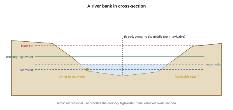
Which feature is the boundary is not obvious. A river has a channel, a bank, a high-water line, a low-water line, a flood line and a vegetation line, and each moves differently. The legal boundary is usually one of these as defined by statute or case law, and it is rarely the water's edge on the day of the survey, which depends on recent rainfall, irrigation releases and dam operations. On a river regulated for irrigation, as the St. Mary and Sun rivers both are, the waterline on survey day says almost nothing about where the boundary lies.
In Montana, the state owns the beds of navigable rivers and lakes, a right it took at statehood in 1889 under the federal equal footing doctrine. Montana's statute on owners of land bounded by water says that, unless the grant shows a different intent, an owner whose land borders a navigable lake or stream takes to the edge of the water at the low-water mark, and an owner whose land borders any other water takes to the middle of the lake or stream. Navigability for this purpose is a federal question, decided reach by reach as of statehood. In PPL Montana v. Montana in 2012, the US Supreme Court held that the courts must examine navigability segment by segment, and that the Great Falls reach of the Missouri River, with its falls and long portage, was not navigable at statehood, so the state did not take title to that riverbed. Separately, Montana's 1985 Stream Access Law, following the state Supreme Court's 1984 decision in Montana Coalition for Stream Access v. Curran, lets the public use rivers and streams capable of recreational use up to the ordinary high-water mark, whoever owns the bed.
Accretion, erosion, reliction and avulsion
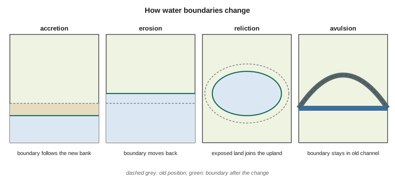
Four processes change water boundaries. Accretion is the gradual and imperceptible deposit of soil along a bank, which builds new land, called alluvion, against the riparian parcel. Erosion is the gradual and imperceptible wearing away of a bank. Reliction is the gradual retreat of water, exposing land that was once covered, as when a lake level falls over decades. Avulsion is a sudden and perceptible change, such as a river cutting a new channel across a meander in a single flood. The common-law rule, followed in both Canada and the United States, is that gradual changes move the boundary with the water, while sudden ones do not: after an avulsion, the boundary stays where the old channel was.
The reasons are practical. If a boundary could not move with gradual change, a riparian owner would slowly lose access to the water as a strip of new land formed between the parcel and the river, owned by someone else; and an owner whose land eroded would keep title to land under water. Letting the boundary follow gradual change keeps each owner on the water. An avulsion, by contrast, can be seen and dated, so the old boundary can still be located, and it would be unfair for a flood to transfer a whole field from one owner to another overnight. The difficulty in practice is telling which process happened. A river that moved 100 m in 60 years may have done it gradually, or in two or three floods, and the evidence comes from old surveys, aerial photographs, flood records and testimony.
For navigable waters in Montana, accretion and reliction generally add land to the riparian owner and erosion takes it away, while the state's bed moves with the river. Where the river is non-navigable, each owner already runs to the middle, and the thread of the stream moves with gradual change. Islands raise further questions: an island formed in a navigable river may belong to the state, while one in a non-navigable river belongs to the owner on whose side of the thread it formed. These rules are worth checking against current Montana statutes and case law before any decision, because they are frequently litigated.
Dividing accreted land among owners
When a bank moves, the new land must be divided among the riparian owners. The simplest approach extends each side line straight across the new land to the new bank, but that can give some owners a long frontage and leave others with none, especially where the bank has changed shape. Courts have therefore often divided the new bank in proportion to each owner's frontage on the old bank, then drawn new side lines from the old division points to the new ones. The method a court will accept depends on the jurisdiction and the shape of the change, and some courts prefer methods that run lines perpendicular to the general course of the river. Theo computes the proportional division for the four parcels below the intake to show the district what is at stake.
import math
# Accretion along the river: divide the new bank among riparian owners in proportion to old frontage
old_bank = [(0, 100.0), (90, 128.0), (180, 104.0), (280, 150.0), (390, 101.0), (470, 112.0), (560, 108.0), (800, 103.0)]  # 1958 plan
new_bank = [(0, 62.0), (200, 55.0), (420, 50.0), (600, 56.0), (800, 66.0)]                                     # 2026 survey
owners = [("Haugen", 0, 180), ("Kovac", 180, 390), ("district", 390, 560), ("Sato", 560, 800)]

def n_at(line, e):
    for (xa, ya), (xb, yb) in zip(line, line[1:]):
        if xa <= e <= xb: return ya + (yb - ya) * (e - xa) / (xb - xa)

def length(line, e1, e2, step=0.5):
    pts = [(e1 + i * step, n_at(line, e1 + i * step)) for i in range(int(round((e2 - e1) / step)) + 1)]
    return sum(math.dist(a, b) for a, b in zip(pts, pts[1:]))

def easting_at_length(line, target, step=0.5):
    run, e = 0.0, 0.0
    while e < 800 and run < target:
        run += math.dist((e, n_at(line, e)), (e + step, n_at(line, e + step))); e += step
    return e

old_total = length(old_bank, 0, 800); new_total = length(new_bank, 0, 800)
print(f"old bank {old_total:.1f} m, new bank {new_total:.1f} m")
print("owner      old frontage   share of new bank   new line ends at E (proportional | straight south)")
run = 0.0
for name, e1, e2 in owners:
    f = length(old_bank, e1, e2)
    share = f / old_total * new_total; run += share
print(f"{name:9s} {f:8.1f} m {share:8.1f} m {easting_at_length(new_bank, run):6.1f} | {e2:6.1f}")old bank 828.8 m, new bank 800.5 m owner old frontage share of new bank new line ends at E (proportional | straight south) Haugen 187.4 m 181.0 m 181.0 | 180.0 Kovac 230.5 m 222.6 m 403.5 | 390.0 district 170.8 m 165.0 m 568.5 | 560.0 Sato 240.1 m 231.9 m 800.0 | 800.0
The old bank wandered around the gravel bar, so it was about 829 m long; the new bank is straighter and about 801 m long. Shared in proportion, the Kovac parcel, whose old frontage included the largest bend, ends 403.5 m along the new bank instead of at 390 m where its side line would meet the new bank if run straight south. That 13.5 m difference decides whether the district's pump station sits on Kovac land or on the district's own parcel. Ruth's advice to the district is that the computation shows a real question of law, not an answer: before the station is built, the district should settle the boundary by agreement with the Kovacs or seek a legal opinion on which method applies.
Worked problem
Proportional share of a new bank
Two owners had 300 m and 500 m of frontage on an old bank 800 m long. Accretion has formed a new bank 720 m long. How long is each owner's share of the new bank?
Show solution
- \[s_1 = 720 \times \frac{300}{800} = 270\ \text{m}\]
- \[s_2 = 720 \times \frac{500}{800} = 450\ \text{m}\]
Answer: 270 m and 450 m. Each owner keeps the same fraction of the bank as before.
Reservoirs and artificial waters
The district's own storage reservoir raises a different question. When a dam floods a valley, the new shoreline is artificial, and the rules for natural water boundaries do not simply carry over to it. The land under the reservoir was usually acquired by the dam's owner, outright or by a flowage easement giving the right to flood it up to a stated elevation, and the boundaries of that land were surveyed before the water rose, by courses and distances or by an elevation contour. A parcel described as running to the reservoir therefore usually runs to a surveyed line or contour, not to wherever the water happens to be. The district's 1950s acquisition plans for the reservoir show a taking line at a fixed elevation with an added margin for wave action, and Ines will retrace that line from its monuments and its elevation, using the vertical datum of the original survey, rather than from the shoreline. Canals, ditches and drains built by people are likewise artificial features: a parcel bounded by a canal is bounded by the right-of-way line the canal sits in, not by the water.
Locating the bank on the ground
Ines's crew walks the river with the district's environmental scientist. They look for the line where the water has left its mark over many years: where the soil changes from sorted sand and gravel to developed topsoil, where vegetation changes from willow and sedge to upland grass, where there is a scarp or a line of drift. They photograph and survey that line, compare it with the 1958 plan and with aerial photographs from the 1950s onward, and note any signs of sudden change, such as an abandoned channel with a sharp edge. The legal bank they record is a professional judgment supported by that evidence, and the plan says so.
Two practical cautions apply on regulated rivers. First, dams and irrigation diversions change flows, so the marks the water leaves today may differ from those it left before regulation; the legal bank is still where the water has shaped it, but the evidence takes more care to read. Second, a feature built by people, such as riprap or a dyke, does not usually create a natural boundary; the boundary may lie behind or under it. The district's own intake works will need their own plan showing the bank as it stood before construction.
Common mistakes
MistakeSurveying the waterline on survey day as the boundary.
InsteadLocate the legal bank or mark defined by law, from evidence of long-term water action.
MistakeAssuming every change in a river is accretion.
InsteadLook for evidence of sudden change; after an avulsion the boundary stays in the old channel.
MistakeExtending side lines straight across accreted land without thinking.
InsteadConsider the method the courts in the jurisdiction apply; proportional division may be required.
MistakeTreating riprap or a dyke as the natural boundary.
InsteadStructures built by people do not usually define a natural boundary.
Summary and key terms
- Natural boundaries follow a water feature defined by law, located as it stands today.
- In Montana, ownership runs to low water on navigable waters and to the middle on others; the public may use rivers to the ordinary high-water mark.
- Accretion, erosion and reliction move the boundary; avulsion does not.
- New land may be divided among riparian owners in proportion to their old frontage, depending on the law.
- The bank is located from soil, vegetation, scarps, earlier surveys and air photos, not the day's water level.
- Water boundary questions often need legal advice before construction decisions.
- Natural boundary
- A boundary formed by a natural feature such as the edge of a body of water.
- Accretion
- Gradual, imperceptible deposit of soil that builds new land against a bank.
- Avulsion
- A sudden, perceptible change in a water course that does not move the boundary.
- Reliction
- Gradual retreat of water that exposes land once covered.
- Riparian owner
- An owner of land bordering a river or stream.
- Ordinary high water mark
- The line on a bank to which water ordinarily rises, shown by soil and vegetation.
- Thread of the stream
- The middle line of a stream, a boundary for some non-navigable waters.
Practice problems
Work each problem on paper first, then reveal the answer to check.
A river moved 60 m in one night during the 1995 flood. Where is the boundary?
Show answer
In the old channel, because the change was an avulsion.
Why is the waterline on survey day a poor guide to a legal water boundary?
Show answer
It depends on recent flows and regulation, not on the long-term mark the law uses.
Two owners had 200 m and 600 m of an old bank; the new bank is 1000 m. Give each share.
Show answer
250 m and 750 m.
Name two kinds of evidence used to locate a legal bank.
Show answer
Changes in soil and vegetation, scarps, drift lines, earlier surveys and aerial photographs.
What happens to a water boundary when a bank erodes gradually?
Show answer
It moves back with the bank.
Lesson quiz · 5 questions
Score 60% or more to complete this lesson.
Create a free account to save your progress, take quizzes and earn a certificate.