
GEOM-410 · Lesson 8 of 12 · 20 min
Subdivision plans
Ruth's project for the district has a second strand. Southern farmland near the city is being divided into country-residential lots, and several proposals cross or border the district's canals. One owner, Mr. Sato, wants to divide a 16.19 ha parcel beside Lateral 7 into five lots of 2 to 4 ha, with a short internal road. He hires Coulee Geomatics to prepare the subdivision, and the district asks to see the plans before they are approved, because every new lot is a new neighbor for its canal. This lesson explains how subdivision plans are made and approved, and what the surveyor contributes.
Why subdivision is regulated
Dividing land creates new parcels that will be bought, built on and served for generations, so governments regulate it. Subdivision rules make sure that new lots have legal and physical access, that they can be served by water, sewage disposal, power and roads, that they fit the local plan and zoning, that they do not create hazards such as building in a floodway, and that land needed for parks, schools, environmental protection and public works is set aside. They also protect the cadastre: a subdivision is not complete until a plan of survey is approved and filed, so that every new parcel has a surveyed, monumented boundary from the day it exists.
In Montana, subdivision of land outside the larger cities is governed by the Montana Subdivision and Platting Act and the subdivision regulations each county adopts under it. Since 2023, the Montana Land Use Planning Act has applied a new framework, including its own subdivision review procedure, to cities of at least 5,000 people in counties of at least 70,000, which includes Great Falls; other local governments may opt in. Mr. Sato's parcel lies outside the city in Cascade County, so the county's subdivision regulations under the Subdivision and Platting Act apply. The owner submits a preliminary plat; the county reviews it against the statutory criteria and its regulations, holds a hearing where required, and approves, conditionally approves or denies it. After the conditions are met, the surveyor prepares the final plat, the county approves it, and it is filed with the county clerk and recorder, which state law requires before any lot can be sold.
What the approving authority looks at
Montana's Subdivision and Platting Act requires the governing body to consider the effects of a subdivision on agriculture, agricultural water user facilities, local services, the natural environment, wildlife and wildlife habitat, and public health and safety. Agricultural water user facilities, which include irrigation canals and ditches, are named explicitly, so the district's comments carry real weight. Counties may require the subdivider to dedicate park land, on a sliding scale that falls as lots get larger, with no dedication for lots larger than 5 acres, or to pay cash in place of land. They may also require easements for utilities and for the district's canals, and many require the plat to show irrigation ditches and the easements that serve them.
The surveyor's work
The surveyor's work on a subdivision runs from the first sketch to the last monument. It starts with a retracement of the parent parcel, because the new lots must fit inside boundaries that are correctly located. Then the surveyor helps design the layout: lot shapes and sizes that meet the bylaw or regulations, roads that meet the municipality's standards, reserves or parks in the right places, and easements for utilities and the canal. Once the layout is approved, the surveyor computes it to close, sets monuments at the lot corners and along the roads, prepares the final plan or plat to the required standard, and signs it. After filing, the monuments on the ground and the plan in the record together define the new lots.
In Montana, the board that licenses land surveyors adopts uniform standards for final plats and certificates of survey, covering their format, the information they must show and the monumentation of corners. A final plat must show every lot and road with its bearings, distances and area, the monuments found and set, the ties to PLSS corners, the easements, and the certificates of the surveyor, the owner and the approving body. Certificates of survey are used for divisions that are exempt from subdivision review, such as some boundary relocations and certain family transfers, but the exemptions are narrowly defined, and counties review their use to prevent evasion of review.
Checking Mr. Sato's layout
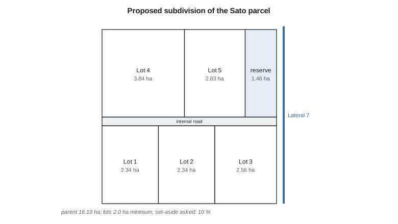
Before the application goes in, Theo checks the layout: every lot meets the minimum size and frontage, the lots, road and reserve add up exactly to the parent parcel, the land set aside meets what the approving authority will ask for, and each lot closes from its bearings and distances.
import math
# Proposed country-residential subdivision of a 16.19 ha parent parcel near the canal (m, plan grid)
def area(p):
    return abs(sum(p[i][0] * p[(i+1) % len(p)][1] - p[(i+1) % len(p)][0] * p[i][1] for i in range(len(p)))) / 2
parent = [(0, 0), (402.34, 0), (402.34, 402.34), (0, 402.34)]
lots = {
    "Lot 1": [(0, 0), (130, 0), (130, 180), (0, 180)],
    "Lot 2": [(130, 0), (260, 0), (260, 180), (130, 180)],
    "Lot 3": [(260, 0), (402.34, 0), (402.34, 180), (260, 180)],
    "Lot 4": [(0, 200), (190, 200), (190, 402.34), (0, 402.34)],
    "Lot 5": [(190, 200), (330, 200), (330, 402.34), (190, 402.34)],
    "reserve": [(330, 200), (402.34, 200), (402.34, 402.34), (330, 402.34)],
    "road": [(0, 180), (402.34, 180), (402.34, 200), (0, 200)],
}
min_lot_ha, min_front = 2.0, 100.0
set_aside_pct = 10.0                        # land asked for as reserve, park or canal buffer (percent of parent)
tot = 0.0
for name, p in lots.items():
    a = area(p); tot += a
    front = p[1][0] - p[0][0] if name.startswith("Lot") and p[0][1] == 0 else (p[2][0] - p[3][0] if name.startswith("Lot") else None)
    msg = ""
    if name.startswith("Lot"):
        msg = "ok" if a / 1e4 >= min_lot_ha and front >= min_front else "below minimum"
        msg = f"frontage {front:6.2f} m  {msg}"
    print(f"{name:8s} {a/1e4:7.4f} ha  {msg}")
print(f"sum {tot/1e4:.4f} ha vs parent {area(parent)/1e4:.4f} ha (difference {abs(tot-area(parent)):.3f} m2)")
res = area(lots["reserve"]) / area(parent) * 100
print(f"reserve is {res:.1f} % of the parent; asked for {set_aside_pct:.0f} %: {'enough' if res >= set_aside_pct else 'short'}")

# Closure of Lot 3 from its plan bearings and distances
legs = [(89 + 59/60 + 40/3600, 142.341), (0 + 25/3600, 180.012), (269 + 59/60 + 50/3600, 142.336), (180 + 10/3600, 180.004)]
dE = sum(d * math.sin(math.radians(b)) for b, d in legs); dN = sum(d * math.cos(math.radians(b)) for b, d in legs)
mis = math.hypot(dE, dN)
print(f"Lot 3 misclosure {mis*1000:.1f} mm in a perimeter of {sum(d for _, d in legs):.3f} m: 1 in {sum(d for _, d in legs)/mis:,.0f}")Lot 1 2.3400 ha frontage 130.00 m ok Lot 2 2.3400 ha frontage 130.00 m ok Lot 3 2.5621 ha frontage 142.34 m ok Lot 4 3.8445 ha frontage 190.00 m ok Lot 5 2.8328 ha frontage 140.00 m ok reserve 1.4637 ha road 0.8047 ha sum 16.1877 ha vs parent 16.1877 ha (difference 0.000 m2) reserve is 9.0 % of the parent; asked for 10 %: short Lot 3 misclosure 23.4 mm in a perimeter of 644.693 m: 1 in 27,508
All five lots exceed 2.0 ha and 100 m of frontage, and the pieces add up to the parent's 16.1877 ha with no gap or overlap. The land set aside along the canal is 1.46 ha, or 9.0 % of the parent, short of the 10 % the authority is expected to ask for. Theo widens the reserve by 8 m along its west side, taking the area from Lot 5, which remains above the minimum. Lot 3 closes to 23 mm in a perimeter of about 645 m, about 1 in 27,500, from the plan bearings and distances; that is the arithmetic of the plan, and the final plan will be computed from adjusted coordinates so that every lot closes exactly.
Worked problem
How much land to set aside
A parent parcel of 16.19 ha is to be subdivided, and the approving authority asks for 10 % as reserve or park land. The road takes 0.80 ha. How much land must be set aside, and how much is left for lots?
Show solution
- \[\text{set aside} = 0.10 \times 16.19 = 1.619\ \text{ha}\]
- \[\text{lots} = 16.19 - 1.619 - 0.80 = 13.77\ \text{ha}\]
Answer: About 1.62 ha set aside and 13.77 ha left for lots. Confirm with the approving authority whether the percentage applies before or after roads.
Monuments and the timeline
Monuments are what make a subdivision usable on the ground. The plan must say what was found and what was set at every corner, and each set monument must meet the standard for its type: usually a steel bar or pipe of stated size and length, with a cap stamped with the surveyor's identification, set firmly in the ground. In cultivated or developing land, monuments get knocked out by graders, fence crews and landscapers, so many surveyors set them only after the road is built, or set witness monuments offset from corners that will be disturbed, with the offsets shown on the plan. The surveyor's job is not only to set monuments but to leave a record from which they can be replaced if they are lost.
Timing matters too. A subdivision often takes a year or more from first sketch to filed plan: design, application, circulation to agencies, decision, conditions such as road construction and service agreements, final survey, plan preparation, and filing. Theo builds a schedule for Mr. Sato that allows for the district's review and for the final survey after the road is built, so that the road monuments survive. If the plan were filed before construction and the monuments were later destroyed, every lot buyer would inherit a boundary that had to be re-established before anyone could build a fence.
Finally, the plan is a public document that will be read for decades. Every dimension, area and note must be correct and clear, because buyers, builders, municipalities and future surveyors will rely on it without ever asking the surveyor what was meant. A plan that is ambiguous about where the canal strip runs, or that shows an area that does not match its dimensions, creates the kind of confusion this whole project exists to clear up.
The canal and the new lots
For the district, the most important line on Mr. Sato's plan is the canal right of way. It must be shown correctly, retraced from the instrument that created it, so that no lot is sold with a canal inside it that the buyer does not know about. The district asks for three things: that the reserve parcel along the canal be at least as wide as the right of way plus a maintenance buffer, that no lot have its only access across the canal, and that the plan note the district's right of way and any crossing agreements. Ruth adds a fourth: monuments along the right of way limits where they meet the lot lines, so that future owners can see where the canal strip begins. Each request becomes a condition of approval or a feature of the plan.
Subdivision is also a chance to repair old problems. Where the canal has drifted outside its 1952 strip on Mr. Sato's land, the subdivision can create a new registered or recorded right of way on the canal as built, and the old strip can be released, with both the owner's and the district's agreement. Ruth's report for the district lists every subdivision application in its area as a possible opportunity to secure or correct its rights.
Common mistakes
MistakeDesigning lots before retracing the parent parcel.
InsteadRetrace first; new lots must fit correctly located outer boundaries.
MistakeComputing reserves from the wrong base area.
InsteadConfirm with the approving authority how the percentage is calculated.
MistakeLeaving the canal right of way off a subdivision plan.
InsteadShow it from its instrument and note it, so buyers know what they buy.
MistakeTreating a closure of 1 in 27,500 as good enough for the final plan.
InsteadCompute the final plan from adjusted coordinates so every lot closes exactly.
Summary and key terms
- Subdivision is regulated to ensure access, services, safety and fit with local plans, and to protect the cadastre.
- In Montana, counties decide under the Subdivision and Platting Act, and larger cities under the Land Use Planning Act; final plats are filed with the clerk and recorder.
- Park dedication follows a sliding scale by lot size; agricultural water user facilities are a review criterion.
- The surveyor retraces the parent, helps design the layout, computes, monuments and signs the plan.
- Layout checks: minimum sizes and frontages, total area against the parent, set-aside land and closure.
- Subdivision is a chance to secure or correct canal rights of way.
- Subdivision
- The division of a parcel into new parcels, subject to approval.
- Preliminary plat
- The proposed layout submitted for approval.
- Final plat
- The surveyed plat that, once approved and filed, creates the new lots.
- Park dedication
- Land or cash provided in Montana subdivisions for parks.
- Agricultural water user facilities
- Irrigation canals, ditches and related works named as a review criterion.
- Certificate of survey
- A recorded survey document used for boundary surveys and exempt divisions in Montana.
- Exempt division
- A division of land that state law excuses from subdivision review.
Practice problems
Work each problem on paper first, then reveal the answer to check.
A 20.00 ha parcel must give 10 % as reserve. How much is that?
Show answer
2.00 ha.
Why does the district want to review subdivisions beside its canals?
Show answer
Each new lot affects canal access, crossings and the security of its right of way.
What must the lots, roads and reserves of a subdivision add up to?
Show answer
Exactly the area of the parent parcel.
Give one way a subdivision can correct a canal that has drifted off its right of way.
Show answer
Create a new right of way on the canal as built and release the old strip, by agreement.
Why should monuments be set where right-of-way limits meet lot lines?
Show answer
So owners can see where the canal strip begins on the ground.
Lesson quiz · 5 questions
Score 60% or more to complete this lesson.
Create a free account to save your progress, take quizzes and earn a certificate.