
BIOL-208 · Lesson 2 of 12 · 25 min
Climate, biomes and ecozones
Drive north from Windsor to Inuvik, or from southern Texas to the Alaskan Arctic, and the living landscape changes in a predictable order: broadleaf forest gives way to mixed forest, then to the dark conifers of the boreal forest, then to stunted trees, and finally to treeless tundra. Similar sequences appear on every continent, even where the species are completely different. The reason is climate. Temperature and precipitation, and how they vary through the year, set the basic conditions every organism must cope with. This lesson explains why climate varies across the globe, how ecologists classify the world's major ecosystems into biomes, and how Canada and the United States divide their own territory into ecological regions for science and management.
Why climate varies: the uneven Sun
The most important fact in global ecology is that the Sun heats Earth unevenly. Near the equator, sunlight strikes the surface almost vertically and its energy is concentrated on a small area. Toward the poles, the same beam strikes at a low angle and spreads over a larger area, and it passes through more atmosphere on the way. The energy received per square meter falls roughly with the cosine of latitude at the equinoxes. Earth's tilt of about 23.4° means that the angle changes through the year, producing seasons that become more extreme toward the poles.
Here \( I_0 \) is the intensity of sunlight on a surface facing the Sun directly and \( \phi \) is latitude at the equinox. At 45° N, roughly the latitude of Ottawa or Minneapolis, the equinox noon intensity is about 71 percent of that at the equator; at 70° N, in the Arctic archipelago, it is about 34 percent.
import math
for place, lat in [("Equator", 0), ("Miami", 25.8), ("Toronto", 43.7),
                   ("Edmonton", 53.5), ("Yellowknife", 62.5), ("Resolute", 74.7)]:
    rel = math.cos(math.radians(lat))
print(f"{place:12s} {lat:5.1f} deg relative noon intensity at equinox: {rel:.2f}")Equator 0.0 deg relative noon intensity at equinox: 1.00 Miami 25.8 deg relative noon intensity at equinox: 0.90 Toronto 43.7 deg relative noon intensity at equinox: 0.72 Edmonton 53.5 deg relative noon intensity at equinox: 0.59 Yellowknife 62.5 deg relative noon intensity at equinox: 0.46 Resolute 74.7 deg relative noon intensity at equinox: 0.26
Atmospheric circulation and rainfall belts
Uneven heating drives the circulation of the atmosphere. Warm, moist air rises at the equator, cools as it rises, and drops its water as heavy rain, which is why tropical rainforests lie along the equator. The now-dry air spreads toward the poles and sinks at about 30° N and S, warming as it descends. Sinking warm air absorbs moisture rather than releasing it, so the great deserts of the world, including the Sonoran and Chihuahuan deserts of the southwestern United States and northern Mexico, cluster near these latitudes. A second zone of rising air near 60° brings moderate precipitation to the temperate and boreal zones, and air sinks again over the poles, making the high Arctic a cold desert with very little precipitation. These circulation cells, named after George Hadley and William Ferrel, and the polar cell, together with Earth's rotation, also produce the prevailing winds: easterly trade winds in the tropics and westerlies at mid-latitudes.
Local influences on climate
Within latitude belts, climate is modified by geography. Oceans store heat and release it slowly, so coastal places have milder winters and cooler summers than inland places at the same latitude: Vancouver's January mean is a few degrees above freezing, while Winnipeg's is below −15 °C. This contrast between maritime and continental climates is one of the strongest patterns in North American ecology. Ocean currents matter too: the Gulf Stream warms northwestern Europe, while the cold Labrador Current chills the coast of Newfoundland and Labrador.
Mountains create rain shadows. Moist Pacific air forced up the Coast Mountains and the Cascades cools and drops heavy rain on the windward slopes, supporting temperate rainforests of western red cedar and Sitka spruce. On the leeward side, the descending air is dry, so the interior plateaus and the Okanagan Valley in British Columbia, and eastern Washington and Oregon, are semi-arid. Elevation itself lowers temperature, by roughly 6.5 °C per 1,000 m on average, so climbing a mountain can take you through the same sequence of vegetation zones as traveling hundreds of kilometers north.
Worked problem
Temperature change with elevation
A valley at 500 m has a July mean temperature of 18 °C. Estimate the July mean at a treeline near 2,200 m, using an average lapse rate of 6.5 °C per 1,000 m.
Show solution
- Elevation gain: 2,200 − 500 = 1,700 m.
- Temperature drop: 1.7 × 6.5 = 11.05 °C.
- Estimated July mean at treeline: 18 − 11.05 ≈ 7 °C.
Answer: About 7 °C. This is close to the 6–10 °C warm-season temperatures often associated with treeline worldwide, which is one reason treelines on mountains and the northern treeline share a common climatic basis.
Biomes
A biome is a major type of ecosystem defined by the growth form of its dominant vegetation, such as forest, grassland, shrubland or tundra, and shaped mainly by climate. Biomes are not defined by particular species: the boreal forest of Canada and the taiga of Siberia share very few species but look and function alike, because evergreen conifers suit long, cold winters and short growing seasons wherever they occur. This convergence of form in unrelated organisms facing similar conditions is one of the clearest pieces of evidence that the environment shapes life.
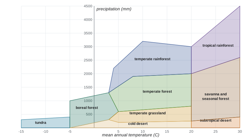
The ecologist Robert Whittaker showed in the 1970s that most terrestrial biomes can be placed on a simple graph of mean annual temperature against mean annual precipitation. Hot and wet gives tropical rainforest; hot and dry gives desert; cold and moderately wet gives boreal forest; very cold gives tundra. Between these, temperate forests, grasslands and shrublands occupy the middle. The boundaries are fuzzy, and soil, fire and grazing shift them: the prairies of central North America receive enough rain to support trees in places, but frequent fire and grazing by bison historically kept them open.
def biome(temp_c, precip_mm):
    """Very rough Whittaker-style classification (illustrative boundaries)."""
    if temp_c < -5:
        return "tundra"
    if temp_c < 3:
        return "boreal forest" if precip_mm > 300 else "tundra or cold desert"
    if temp_c < 20:
        if precip_mm < 250:
            return "temperate desert"
        if precip_mm < 750:
            return "temperate grassland or shrubland"
        if precip_mm < 2000:
            return "temperate deciduous or mixed forest"
        return "temperate rainforest"
    if precip_mm < 300:
        return "subtropical desert"
    if precip_mm < 1500:
        return "tropical savanna or seasonal forest"
    return "tropical rainforest"

# Approximate climate normals (rounded, for illustration)
sites = [("Iqaluit, NU", -9.3, 400), ("Thompson, MB", -2.9, 540),
         ("Regina, SK", 3.0, 390), ("Halifax, NS", 7.5, 1450),
         ("Tofino, BC", 9.3, 3300), ("Phoenix, AZ", 24.0, 200),
         ("Atlanta, GA", 17.0, 1270), ("Miami, FL", 25.5, 1570)]
for name, t, p in sites:
print(f"{name:14s} {t:6.1f} C {p:6d} mm -> {biome(t, p)}")Iqaluit, NU -9.3 C 400 mm -> tundra Thompson, MB -2.9 C 540 mm -> boreal forest Regina, SK 3.0 C 390 mm -> temperate grassland or shrubland Halifax, NS 7.5 C 1450 mm -> temperate deciduous or mixed forest Tofino, BC 9.3 C 3300 mm -> temperate rainforest Phoenix, AZ 24.0 C 200 mm -> subtropical desert Atlanta, GA 17.0 C 1270 mm -> temperate deciduous or mixed forest Miami, FL 25.5 C 1570 mm -> tropical rainforest
The classifier works surprisingly well for most sites, but it is crude. It labels Miami as tropical rainforest, yet south Florida's natural vegetation was pine rockland, sawgrass marsh and hardwood hammock, shaped by a pronounced dry season, hurricanes and fire. Regina falls at the boundary between grassland and boreal forest on temperature alone; it is grassland because its precipitation is low and evaporation in summer is high. Moisture available to plants depends not just on rainfall but on how much evaporates, which rises with temperature. Ecologists therefore often use measures such as the ratio of precipitation to potential evapotranspiration, or a climate diagram that shows monthly temperature and precipitation together, to identify when plants face drought.
The biomes of North America
| Biome | Climate | Dominant vegetation | Examples |
|---|---|---|---|
| Arctic tundra | Very cold; short cool summers; low precipitation; permafrost | Low shrubs, sedges, mosses, lichens | Nunavut, northern Alaska |
| Boreal forest (taiga) | Long cold winters, short summers, moderate precipitation | Black and white spruce, jack pine, tamarack, aspen, birch | Northern Ontario and Quebec, Yukon, interior Alaska |
| Temperate deciduous forest | Warm summers, cold winters, even precipitation | Maples, oaks, beech, hickory | Southern Ontario and Quebec, eastern United States |
| Temperate rainforest | Mild, very wet | Western red cedar, Sitka spruce, western hemlock, Douglas-fir | Coastal British Columbia, Pacific Northwest |
| Temperate grassland | Hot summers, cold winters, low to moderate precipitation, fire | Grasses and forbs | Canadian Prairies, Great Plains |
| Desert | Hot or cold, very dry | Cacti, shrubs such as creosote bush and sagebrush | Sonoran, Mojave and Great Basin deserts |
| Mediterranean shrubland (chaparral) | Hot dry summers, mild wet winters, fire | Evergreen shrubs | Coastal California |
Ecological regions for science and management
Biomes are too coarse for management, so the United States uses ecoregions: areas with similar ecosystems and environmental resources. The Environmental Protection Agency's hierarchical framework, developed by James Omernik and colleagues and harmonized across North America through the Commission for Environmental Cooperation, has four levels. Level I divides North America into 15 broad ecoregions, such as the Great Plains, the Eastern Temperate Forests, the North American Deserts and the Marine West Coast Forest, about a dozen of which occur in the United States. These are subdivided into Level II, Level III (about 105 in the conterminous United States) and Level IV ecoregions, each defined by climate, geology, landforms, soils, vegetation and land use. A parallel system used by the US Forest Service, developed by Robert Bailey, classifies ecoregions into domains, divisions and provinces. Ecoregions are used to set water quality criteria, plan monitoring, report on ecosystem condition and coordinate conservation across agency and state boundaries.
Because the North American frameworks were harmonized through the Commission for Environmental Cooperation, the US ecoregions line up broadly with Canada's ecozones, which are based on similar criteria. This makes it possible to track ecosystems such as the boreal forest or the Great Plains across the border.
Climate is shifting the map
Biome boundaries are not fixed. Over the last 20,000 years, as the ice sheets retreated, tree species migrated hundreds of kilometers northward at different speeds, assembling and disassembling communities as they went; pollen preserved in lake sediments records these shifts. Today, rapid warming is moving climate zones northward and upslope faster than many species can follow. Shrubs are expanding into Arctic tundra, a process visible in satellite records as greening, and the northern edge of the boreal forest is responding unevenly. Lesson 12 examines these changes and their consequences.
Common mistakes
MistakeBiomes are defined by the species that live in them.
InsteadBiomes are defined by the growth form of the dominant vegetation and the climate; similar biomes on different continents can share few species.
MistakeDeserts occur only where it is hot.
InsteadDeserts are defined by low precipitation relative to evaporation; the high Arctic and the Great Basin are cold deserts.
MistakeRainfall alone determines whether a place is grassland or forest.
InsteadEvaporation, soils, fire and grazing also matter; the same rainfall supports forest where it is cool and grassland where it is hot or frequently burned.
MistakeThe equator is hot because it is closer to the Sun.
InsteadIt is hot because sunlight strikes it at a steep angle, concentrating energy; distance to the Sun is essentially the same.
MistakeCoastal and inland sites at the same latitude have the same climate.
InsteadOceans moderate temperature, so coastal sites have milder winters and cooler summers.
Summary and key terms
- Uneven solar heating, greatest at the equator, drives global temperature patterns and atmospheric circulation.
- Rising air near the equator and near 60° brings rain; sinking air near 30° and at the poles creates deserts.
- Oceans, ocean currents, mountains (rain shadows) and elevation modify climate locally.
- Biomes are major ecosystem types defined by dominant growth form and climate; similar biomes converge in form on different continents.
- Whittaker diagrams place biomes on axes of temperature and precipitation, with boundaries shifted by soils, fire and grazing.
- Canada uses ecozones and the United States uses ecoregions, harmonized at the continental level, for science and management.
- Biome boundaries have shifted before and are shifting now with climate change.
- biome
- A major ecosystem type defined by the growth form of its dominant vegetation and shaped by climate.
- rain shadow
- The dry area on the leeward side of a mountain range.
- lapse rate
- The decrease of air temperature with elevation, about 6.5 °C per 1,000 m on average.
- Hadley cell
- The tropical circulation loop in which air rises at the equator and sinks near 30° latitude.
- continental climate
- A climate with large seasonal temperature swings, typical of inland areas.
- maritime climate
- A climate moderated by the ocean, with mild winters and cool summers.
- ecozone
- The broadest level of Canada's ecological land classification.
- ecoregion
- An area with similar ecosystems and environmental resources, used for management.
- convergent evolution
- The evolution of similar forms in unrelated organisms facing similar conditions.
- permafrost
- Ground that stays at or below 0 °C for at least two consecutive years.
Practice problems
Work each problem on paper first, then reveal the answer to check.
Why are many of the world's deserts near 30° N and S?
Show answer
Air that rose and rained out at the equator sinks there, warming and drying as it descends.
Estimate the relative equinox noon solar intensity at 60° N.
Show answer
cos 60° = 0.5, half that at the equator.
Explain why Vancouver has milder winters than Winnipeg.
Show answer
Vancouver's climate is moderated by the Pacific Ocean; Winnipeg is continental.
A valley at 300 m averages 20 °C in July. Estimate the July mean at 1,800 m.
Show answer
1.5 km × 6.5 °C/km = 9.75 °C cooler, about 10 °C.
Why do the boreal forest and Siberian taiga look alike despite sharing few species?
Show answer
Similar climates select similar growth forms, an example of convergence.
Why is the high Arctic called a cold desert?
Show answer
It receives very little precipitation, often less than 250 mm a year.
Give two factors besides climate that can keep grassland from becoming forest.
Show answer
Frequent fire and grazing; soils can also matter.
What is a rain shadow? Give a North American example.
Show answer
The dry area leeward of mountains; the Okanagan Valley or eastern Washington.
Name the level used for national ecological reporting in your country.
Show answer
Canada: ecozones (15 terrestrial). United States: ecoregions (EPA Levels I to IV).
What evidence shows that biome boundaries have moved in the past?
Show answer
Pollen preserved in lake sediments records the northward migration of tree species after glaciation.
Lesson quiz · 5 questions
Score 60% or more to complete this lesson.
Create a free account to save your progress, take quizzes and earn a certificate.