
ARCH-340 · Lesson 9 of 12 · 19 min
Planning tools and guidelines
Priya Natarajan, the city facilities manager who was the client for the hub in ARCH-200, comes to the studio with a box of documents: the city's comprehensive plan, the zoning maps for the district, a set of design guidelines for main streets written fifteen years ago, a heritage inventory, a transportation master plan and a parks strategy. 'This is what actually builds a district,' she says, tipping them onto the table. 'Not your beautiful framework drawings. These. Most buildings on the avenue in the next twenty years will be designed by architects who have never heard of you, for owners who want to build as much as they can as cheaply as they can, and approved by a planner who has twenty minutes to read each file. If your ideas are not written into rules and documents like these, they will not happen.' Desrosiers nods. This lesson is about those tools and how urban designers use them.
The planning system
Land use planning in North America is mainly the responsibility of local governments, acting under powers given by state law. In Minnesota, the Metropolitan Land Planning Act requires the cities of the Twin Cities region to prepare comprehensive plans, reviewed by the Metropolitan Council every ten years, and to make their zoning consistent with them. Minneapolis 2040 is the city's comprehensive plan, and its zoning code was rewritten to implement it, including built form districts that set building scale separately from use.
A typical planning system has a hierarchy of documents, from broad to specific:
- A city-wide plan states goals and policies and maps general land use, growth areas, transit corridors and parks. It guides, but does not itself regulate individual lots.
- Area or secondary plans cover a district or corridor in more detail, such as a station area, a downtown precinct or a redevelopment site.
- The zoning by-law or code regulates what can be built on each lot: uses, height, density, setbacks, coverage, parking and sometimes design.
- Subdivision rules govern how land is divided into lots and streets, and what infrastructure and parkland the developer must provide.
- Design guidelines and standards describe the quality expected for buildings, streets and public spaces, with more or less legal force.
- Site plan or design review lets the city review individual projects against the rules and guidelines.
- Capital budgets and programs fund public streets, parks, transit and buildings, which are often the most powerful tools of all.
Zoning
Zoning divides a city into districts and sets rules for each. Modern zoning began in Germany in the late nineteenth century and spread to North America in the early twentieth; New York's zoning resolution of 1916, prompted partly by the shadows of the Equitable Building, introduced height and setback rules. In 1926 the United States Supreme Court upheld zoning in Village of Euclid v. Ambler Realty, and 'Euclidean zoning', which separates uses into exclusive districts, became the norm across the continent.
Conventional zoning controls quantity and use. Its main tools are permitted uses, maximum height, maximum FAR or density, setbacks, lot coverage, minimum lot size and parking requirements. These tools are good at preventing conflicts, such as a factory beside a house, and at limiting the size of buildings. They are poor at producing good streets. A zoning envelope says how big a building may be and where it may not be, but not where its door should be, whether its ground floor has windows, or whether it lines up with its neighbors. Rules written to separate uses have also made mixed-use districts illegal in many places, and minimum lot sizes and single-detached zoning have been used to exclude people by income and, historically, by race.
The students test the zoning that applies to a typical lot on the avenue: how much floor area the rules allow, and whether the envelope or the FAR limit governs.
# Conventional zoning envelope versus a form-based frontage rule
lot_w, lot_d = 130, 120            # ft
front, side, rear = 10, 5, 20  # setbacks, ft
height, floor_h = 50, 12        # ft
coverage_max, far_max = 0.60, 2.0
lot = lot_w * lot_d
fp = min((lot_w - 2 * side) * (lot_d - front - rear), coverage_max * lot)
floors = int(height // floor_h)
area_env = fp * floors
area = min(area_env, far_max * lot)
print(f"lot {lot:,.0f} ft2; footprint {fp:,.0f}; {floors} floors fit; envelope {area_env:,.0f}; "
      f"FAR cap {far_max * lot:,.0f}; allowed {area:,.0f} ft2")
# Form-based rule: build-to line within 6 ft of the front, frontage occupied at least 80%
facade = 100                  # building width placed on the build-to line, ft
share = facade / (lot_w - 2 * side)
print(f"frontage occupied {share:.0%}: " + ("meets" if share >= 0.8 else "fails") + " the 80% rule")lot 15,600 ft2; footprint 9,360; 4 floors fit; envelope 37,440; FAR cap 31,200; allowed 31,200 ft2 frontage occupied 83%: meets the 80% rule
The envelope allows more floor area than the FAR limit, so the FAR limit governs. Nothing in the zoning, however, says where on the lot the building should go. A four-story building could sit at the back of the lot behind a parking lot, and it would comply. That is exactly what happened on part of the avenue in the 1970s.
Form-based codes
Form-based codes regulate the physical form of buildings and their relationship to the street first, and use second. Instead of a setback, they set a build-to line where the facade must stand. They require a share of the frontage to be occupied by the building, set the height of the ground floor, require entrances on the street and a minimum share of windows, set where parking may go (behind or under buildings) and define building types allowed in each area. Many are organized around the transect, a sequence of zones from natural to rural to urban core, developed by Andrés Duany and colleagues around 2000, and illustrated with diagrams rather than dense text.
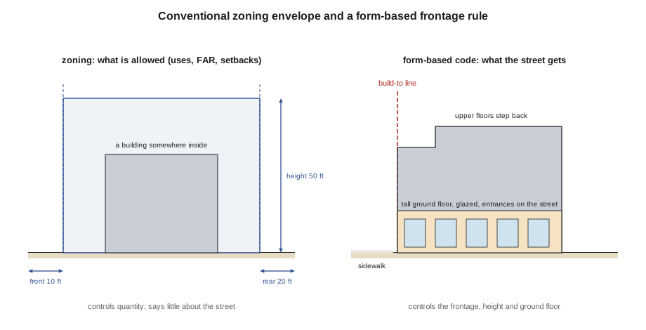
The code output above showed a frontage rule: the building must stand within a short distance of the front lot line and occupy at least 80% of the lot's width. Many cities now combine conventional and form-based approaches, adding frontage and ground-floor rules to zoning districts along main streets. Form-based codes have critics too: they can be rigid, may freeze a particular style, and do not by themselves address affordability or who gets to live in a place.
Design guidelines
Design guidelines describe the qualities that new buildings and public spaces should have, usually with illustrations. They are often less binding than zoning; a planner may apply them through design review, and a developer may argue against them. Good guidelines are short, specific, illustrated, prioritized and tied to clear goals. Bad guidelines are long lists of vague wishes ('buildings should be attractive and respect their context') that give no one useful direction.
Desrosiers asks each student to write one guideline for the avenue and test it against three imagined projects. Ingrid's reads: 'Ground floors facing the avenue have a floor-to-floor height of at least 15 ft, with clear glazing over at least 60% of the frontage between 2 and 8 ft above the sidewalk, and an entrance at least every 50 ft.' The class agrees that it is clear, measurable and likely to produce shopfronts that can adapt over time. Callum's first draft ('buildings should be friendly to pedestrians') fails the test; his second ('no blank wall longer than 20 ft facing a street or the greenway') passes.
Many cities also use design review panels: groups of architects, landscape architects and planners who review significant projects and advise the planning department or council. A good panel raises the quality of buildings and public spaces by asking questions early, when changes are cheap, and by pointing to the city's adopted goals rather than personal taste. A poor panel adds months of delay and arbitrary demands. Natarajan's advice to the students is to treat design review as a conversation about the public realm: what the building does for the sidewalk, the greenway and its neighbors, rather than its materials or its style. Desrosiers adds that guidelines should be tested before adoption by drawing two or three real projects that meet them, to make sure they produce what is intended and can be built at a reasonable cost.
Tools for public benefit
Plans and rules shape what private owners may build. Other tools help the public get what it needs from development.
- Development agreements and conditions of approval require developers to build or pay for infrastructure, parks, public art or other benefits.
- Density bonuses allow more floor area in exchange for public benefits such as affordable homes, public space or heritage conservation. Many American cities use incentive zoning and inclusionary rules.
- Inclusionary zoning requires or encourages a share of homes in new developments to be affordable.
- Tax increment financing borrows against the increase in property tax that new development is expected to bring to an area, to pay for public improvements there. It is used widely in the United States and, under different rules, in some Canadian cities.
- Public land: when a city, transit agency or other public body owns land, it can control what is built, who builds it and for whom. Public land is one of the strongest tools for affordable housing and public space.
- Heritage designation protects buildings and areas of historic value, and can be combined with incentives for their reuse.
In the greenway district, the city owns the hub site and the greenway; the rail yard belongs to the railway, which is willing to sell; and Greenway Homes owns the lumber yard. The students propose that the city buy the rail yard before announcing the framework, so that rising land values benefit the public, and use it for the stormwater park and for affordable housing built by non-profits.
Writing the framework into rules
A framework plan becomes effective only when its main ideas are written into the planning system. The students translate theirs into a short list of changes.
- An area plan for the district, adopted by council, that fixes the street network (including the reopened streets and new crossings), the greenway, the stormwater park and the plaza.
- Rezoning of the avenue to a mixed-use district allowing four to six stories, with a build-to line, ground-floor rules, no parking minimum and an angular plane at the rear to protect the houses behind.
- Rezoning of the residential streets to allow up to four homes per lot, as Minneapolis 2040 already partly does.
- Design guidelines for the greenway frontage: buildings on the greenway must have doors, windows and balconies facing it, no blank walls or service areas.
- A capital program for the plaza, the avenue's complete street, the greenway crossings and the park, with dates and budgets.
- An affordable housing strategy using the rail yard and Greenway Homes' sites, inclusionary rules and partnerships with non-profits.
Exercise 9: the rules behind a place
- Find the city-wide plan, the zoning and any area plan or guidelines that apply to a main street in your city.
- Calculate the zoning envelope and the FAR limit for one lot, and say which governs.
- Write three design guidelines for the main street that are clear and measurable. Test each against two imagined projects.
- Draft a frontage rule (build-to line, frontage occupancy, ground floor height and glazing) and draw a building that meets it.
- Identify the public land in your district and propose how it could be used.
Rules that change
Natarajan reminds the students that rules are not permanent. Zoning maps and plans are amended constantly, often one lot at a time when an owner applies for a change. That flexibility can be used well, to allow good projects the rules did not foresee, or badly, to let large projects ignore a plan that the community spent years preparing. A framework should therefore say which of its elements are fixed, such as the street network, the greenway, the park and the share of affordable homes, and which are flexible, such as the exact heights of individual buildings or the mix of uses on a particular block. Fixed elements belong in adopted plans and capital budgets; flexible ones belong in guidelines that a design review panel can interpret. The students mark each element of their framework with an F or an X and find, to their surprise, that the list of truly fixed elements fits on a single page.
Common mistakes
MistakeAssuming a beautiful plan drawing will be built.
InsteadWrite its key ideas into the area plan, zoning, guidelines and capital budget.
MistakeWriting vague guidelines.
InsteadMake guidelines specific, measurable, illustrated and few.
MistakeRelying only on setbacks and FAR.
InsteadAdd frontage and ground-floor rules where the street matters.
MistakeKeeping parking minimums near transit.
InsteadRemove or reduce them to make infill and affordable homes possible.
MistakeAnnouncing a plan before securing key public land.
InsteadAcquire strategic sites early so rising values benefit the public.
Summary and key terms
- Local governments plan and regulate land use under state law, through a hierarchy of plans, zoning, subdivision rules, guidelines and review.
- Conventional zoning controls use and quantity; it is good at preventing conflicts but poor at producing good streets.
- Form-based codes regulate the building's relationship to the street: build-to lines, frontage, ground floors and parking location.
- Good design guidelines are short, specific, measurable and illustrated.
- Development agreements, bonuses, inclusionary rules, tax increment financing, public land and heritage designation secure public benefits.
- A framework plan must be translated into adopted rules, budgets and programs to be built.
- Zoning
- Rules dividing a city into districts with permitted uses and limits on building size and placement.
- Euclidean zoning
- Zoning that separates uses into exclusive districts, named after the 1926 Euclid v. Ambler case.
- Form-based code
- A code that regulates building form and its relationship to the street before use.
- Build-to line
- A line at which the front of a building must be placed.
- Density bonus
- Extra floor area allowed in exchange for a public benefit.
- Tax increment financing
- Financing public improvements by borrowing against expected increases in property tax in an area.
Practice problems
Work each problem on paper first, then reveal the answer to check.
A lot of 100 × 130 ft has a FAR limit of 1.5 and an envelope allowing 20,000 ft². How much floor area may be built?
Show answer
19,500 ft²: the FAR limit governs.
Rewrite 'buildings should engage the street' as a measurable guideline.
Show answer
For example: an entrance at least every 50 ft of frontage and clear glazing over 60% of the ground floor facade.
What does a build-to line require that a setback does not?
Show answer
That the building stand at a particular line, rather than merely behind one.
Name two tools that can secure affordable homes in new development.
Show answer
Inclusionary zoning, density bonuses, public land, partnerships with non-profits.
Why might a city buy land before announcing a district plan?
Show answer
So the increase in land value from the plan benefits the public rather than private speculators.
Lesson quiz · 5 questions
Score 60% or more to complete this lesson.
Create a free account to save your progress, take quizzes and earn a certificate.