
ARCH-340 · Lesson 5 of 12 · 21 min
Density and form
At the first public meeting about the greenway district, held in the hub's hall, Ernest Kowalchuk stands up to say what many of his neighbors are thinking. 'We hear the word density and we think of towers,' he says. 'Towers mean shadows, traffic, strangers. Why can't the district stay the way it is?' Desrosiers thanks him, and the next day she shows the class two photographs. One is of a street of three-story row houses in Brooklyn with stoops and trees. The other is of a sixteen-story slab in a field of lawn. 'Which is denser?' she asks. Most of the students choose the slab. The answer is that, on the same land, they hold almost the same number of homes. 'Density is a number,' she says. 'Form is what people see. Most fights about density are really about form, and most bad density is bad form. This lesson gives you the numbers and then shows you how much freedom they leave.'
Measuring density
Density measures how much building, how many homes or how many people occupy a given area of land. Urban designers use several measures, and it matters which one is meant.
- Floor area ratio (FAR), called floor space index in some places, is the total floor area of buildings divided by the area of the lot. A one-story building covering the whole lot has a FAR of 1.0; so does a four-story building covering a quarter of it.
- Lot coverage is the share of the lot covered by buildings. It says how much ground is left open.
- Dwelling density is the number of homes per acre. It is the measure most used for housing and for transit planning.
- Population density is the number of people per acre (or per square mile at city scale); it depends on household size as well as homes.
- Activity density counts residents plus jobs per unit area; it is the best predictor of transit use and of how many shops a district can support.
Density can be net or gross. Net density counts only the land of the lots themselves. Gross density includes the streets, parks, schools and other land in the area. A district's gross density is typically half to two-thirds of the net density of its housing lots, because streets alone take a quarter to a third of the land. When comparing numbers, always ask which is meant.
| Place or building | Approximate FAR | Approximate homes per acre (net) |
|---|---|---|
| Detached houses on 50 ft lots | 0.3 to 0.5 | 6 to 10 |
| Row houses, two to three stories | 0.8 to 1.2 | 16 to 24 |
| Greenway Homes (ARCH-201) | 1.63 | 71 |
| Four- to six-story perimeter block | 2.0 to 3.0 | 60 to 100 |
| Downtown office tower | 8 to 15 | not applicable |
Same density, different form
The key lesson of density is that the same number can take very different forms. The students compare three ways of placing a FAR of 2.0 on the same site: a tower in open space, a mid-rise perimeter block around a courtyard, and low-rise row houses.
# Same floor area ratio, different forms
lot = 108900                   # site area, ft2
far = 2.0
floor_area = lot * far
forms = [  # name, stories, coverage
    ("tower in open space", 16, 0.125),
    ("mid-rise perimeter block", 4, 0.50),
    ("low-rise row housing", 3, 0.667),
]
unit = 915                 # average gross floor area per home, ft2
for name, floors, cov in forms:
    fp = floor_area / floors
    print(f"{name:<26} {floors:>2} floors, footprint {fp:>8,.0f} ft2, coverage {fp / lot:.0%}, "
          f"open ground {lot - fp:>8,.0f} ft2")
homes = floor_area / unit
print(f"all three: {floor_area:,.0f} ft2 of floor area, about {homes:.0f} homes, "
f"{homes / (lot / 43560):.0f} homes per acre")tower in open space 16 floors, footprint 13,612 ft2, coverage 12%, open ground 95,288 ft2 mid-rise perimeter block 4 floors, footprint 54,450 ft2, coverage 50%, open ground 54,450 ft2 low-rise row housing 3 floors, footprint 72,600 ft2, coverage 67%, open ground 36,300 ft2 all three: 217,800 ft2 of floor area, about 238 homes, 95 homes per acre
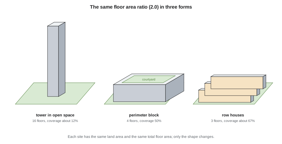
Each form has a different character. The tower leaves most of the ground open, but that ground is often windswept, shaded and nobody's in particular; it needs elevators and costly structure, and few of its homes have direct access to the ground. The perimeter block gives every home a street front and a courtyard back, defines the street with a continuous wall, and gives children a safe shared yard. The row houses give every home its own door on the street and its own small yard, but cover most of the ground and are hard to make more than three stories. None is right in every case. In northern cities the perimeter block has a further advantage: its courtyard is sheltered from wind, and if its south side is kept lower, the courtyard gets winter sun.
Perceived density differs from measured density. People judge density by what they see: building height, the closeness of buildings to the street, the amount of greenery, the number of cars and the quality of design. A well-designed four-story street with trees and doors every few meters feels less dense than a street of houses lined with garage doors, even if it holds four times as many homes.
Why density matters
Density is not a goal in itself. It matters because many things a district needs work only above certain thresholds.
- Transit: frequent bus or rail service needs enough riders within walking distance. Rules of thumb, going back to Boris Pushkarev and Jeffrey Zupan's studies for the New York region in the 1970s, suggest that basic hourly bus service needs roughly 7 homes per acre across its catchment, and frequent service roughly double that. Lesson 6 looks at this in detail.
- Shops and services: a corner store, a café, a pharmacy and a grocery store each need a certain number of customers within easy reach.
- Infrastructure: the cost of streets, pipes, transit, snow clearing and garbage collection per home falls as density rises, because each foot of street serves more households.
- Land and climate: compact districts use less farmland and natural land, and their residents generally drive less and use less energy for heating, because attached buildings share walls.
- Social life: enough people nearby makes it more likely that streets are lively and safe and that neighbors meet.
Density also has costs if done badly: shadows, overlook, loss of privacy, traffic, strain on schools and parks that have not grown with the population, and, when new buildings are expensive, rising land values that can push out existing residents. Good design and planning manage these costs; they do not avoid density.
The missing middle
Between detached houses and apartment towers lies a range of building types that were common in North American cities before the Second World War and were then largely zoned out: duplexes, triplexes, fourplexes, row houses, courtyard apartments and small walk-up apartment buildings. The architect Daniel Parolek named them the missing middle around 2010. They fit on ordinary residential lots, look like large houses from the street and can raise a block's density two or three times without towers.
Many cities have recently changed their zoning to allow these types again. Minneapolis 2040 allowed up to three homes on lots in residential areas across the city, and Minnesota and other states have debated wider reforms. In the greenway district, the streets of small houses north of the avenue are typical candidates. Callum calculates that if one lot in five on those streets became a fourplex over twenty years, the area would add more homes than Greenway Homes without any building taller than three stories.
Mid-rise main streets and towers
Mid-rise buildings of four to eight stories along main streets and transit corridors are the backbone of most density strategies in North American cities, including Minneapolis and the greenway district. They can be built in wood frame, mass timber or concrete; they give the street a continuous wall with shops below and homes above; and they keep the street in sun for much of the day if their height is limited relative to the street's width. Many cities use an angular plane, a line rising at about 45 degrees from the opposite side of the street or from the rear lot line, to set how high and how far back upper floors can go.
Towers have a role at major transit stations and downtowns, where land is most valuable and views and visibility matter. Good tower design keeps floor plates small (about 8,000 ft² for residential towers is a common guideline), separates towers by 80 ft or more for privacy and light, and sets them on podiums that hold the street wall at a human scale. Bad tower design leaves windswept plazas, long shadows and blank parking podiums.
Worked problem
A density gradient around the station
The students propose a gradient of building heights from the hub corner outwards. Estimate the district-scale effect.
Show solution
- Within about 650 ft of the corner, along the avenue: six-story mixed-use buildings at FAR about 3.0.
- Elsewhere along the avenue and on the lumber yard and rail yard sites: four- to five-story buildings at FAR about 2.0, like Greenway Homes.
- On the residential streets: gradual infill with duplexes to fourplexes at FAR 0.6 to 1.0.
- On the greenway: no building; instead, frontages that face it.
- Their estimate of the total, used again in Lesson 12: about 2,600 new homes over twenty-five years, more than half of them along the avenue and on the two large sites.
Answer: The gradient concentrates new homes where transit and shops are and keeps the scale of the existing streets, while doubling the number of people who live within a short walk of the corner.
Sun, shadow and privacy
Density's most visible costs are shadows and overlook. In a northern city the low winter sun makes shadows long: at noon on the winter solstice at about latitude 50 degrees, a building casts a shadow about three and a half times its height; at 45 degrees, about two and a half times. Urban designers test massing with shadow studies at the equinoxes and solstices, especially for parks, schoolyards and sidewalks where people sit. Placing taller buildings on the north side of streets and parks, keeping the south sides lower, and orienting long buildings north-south so their shadows sweep quickly across the ground all help.
Privacy depends on the distance between windows and on what they face. Common guidelines call for about 60 to 80 ft between facing windows of homes in taller buildings, less across a street or courtyard where views are oblique, and for transitions such as stepped heights and trees where new buildings back onto houses.
Exercise 5: density and form
- Find three blocks in your city with similar dwelling densities but different forms. Photograph them and describe how they feel.
- For a site of your choice, test three massing options at the same FAR. Compare coverage, open space, sun on the ground and street frontage.
- Calculate the gross and net density of your district.
- Draw a shadow study of a six-story building on the south side of a park at the winter solstice and at the equinox.
- Identify lots where missing-middle housing could be built under current or proposed rules.
Reading density on the ground
Desrosiers sends the students out with a simple field exercise to train their eyes. On three streets of the district they count homes by mailboxes, doorbells and meters, pace out the length and depth of the blocks, and estimate the net density before checking it against the city's property data. Their first guesses are wildly off. Callum guesses that a street of narrow wartime houses holds about a third of the homes of the walk-up apartment street around the corner; the real figure is closer to half, because the walk-ups have large parking lots behind them. Ingrid is surprised to find that the block of the old lumber yard, with its few sheds, has a lower density than the cemetery across the rail line. By the end of the morning the students' estimates are within about a fifth of the real numbers. Desrosiers explains that this skill matters in public meetings, where people often believe a proposal will be far denser than its neighbors when it is not, and in design, where a quick estimate on site saves hours of wrong assumptions.
Common mistakes
MistakeEquating density with height.
InsteadShow that the same FAR can be achieved with very different forms.
MistakeQuoting a density without saying whether it is net or gross.
InsteadAlways state the measure and the land it is calculated on.
MistakeTreating density as the goal.
InsteadUse it to reach thresholds for transit, shops and infrastructure, and design its form well.
MistakeIgnoring winter shadows.
InsteadTest massing at the winter solstice and keep the south sides of public spaces lower.
MistakePlacing a tower without a podium or street wall.
InsteadHold the street at human scale and separate towers for light and privacy.
Summary and key terms
- Density can be measured as FAR, coverage, homes, people or residents plus jobs per unit area, net or gross.
- The same density can take very different forms; perceived density depends on design.
- Density matters because transit, shops, services and efficient infrastructure need enough people nearby.
- Missing-middle housing and mid-rise main streets can raise density without towers.
- Towers suit major stations and downtowns if designed with small floor plates, separation and podiums.
- Shadow and privacy studies guide where height goes, especially in northern cities with long winter shadows.
- Floor area ratio
- Total floor area of buildings divided by lot area.
- Lot coverage
- The share of a lot covered by buildings.
- Net density
- Density measured on the lots alone, excluding streets and public land.
- Gross density
- Density measured over a whole area, including streets, parks and other land.
- Missing middle
- Building types between detached houses and towers, such as fourplexes, row houses and small walk-ups.
- Angular plane
- A sloping line, often at 45 degrees, that limits building height and sets upper-floor stepbacks.
Practice problems
Work each problem on paper first, then reveal the answer to check.
A lot of 10,000 ft² has a four-story building with a footprint of 4,500 ft². What are its FAR and coverage?
Show answer
FAR 1.8; coverage 45%.
Why is gross density lower than net density?
Show answer
Gross density includes streets, parks and other land without homes.
Name two advantages of a perimeter block in a northern city.
Show answer
A sheltered courtyard, a continuous street wall and, with a lower south side, winter sun in the courtyard.
At about latitude 50 degrees, how long is the noon shadow of a 65 ft building at the winter solstice?
Show answer
About three and a half times its height, roughly 220 ft.
What is the missing middle?
Show answer
Housing types such as duplexes, fourplexes, row houses and small walk-ups between detached houses and towers.
Lesson quiz · 5 questions
Score 60% or more to complete this lesson.
Create a free account to save your progress, take quizzes and earn a certificate.