
ARCH-340 · Lesson 12 of 12 · 19 min
Urban design project
The final review is held in the hub's hall, which the students designed two years earlier in ARCH-200 and which now hums with the noise of a Saturday afternoon. The critics are Tomas Okonkwo, who has reviewed their work since ARCH-200; Priya Natarajan from the city; Beatrice Lafontaine from Greenway Homes; Amir Sadeghi, the transit planner; and Ernest Kowalchuk, who insisted on being on the panel because, as he put it, 'I'm the one who has to live with it.' Thirty residents, some of whom took part in the charrette, sit in rows behind them. The four students have combined their work into a single framework plan for the greenway district, presented on eight boards and a model. This lesson follows the framework from structure to review, and sets out how to prepare a district framework of your own.
What a framework plan contains
A district framework plan sets out the long-term structure of a place and the rules for its growth, without designing every building. A complete framework usually contains:
- A vision: a short statement of what the district should be like in twenty to thirty years, written in plain language and tested with residents.
- Principles: five to eight principles that guide every decision, such as 'every home within a five-minute walk of a park' or 'protections before improvements'.
- A structure plan with layers for movement (streets, paths, transit, cycling), open space (parks, greenways, plazas, green infrastructure), built form (heights, densities, frontages) and land use (where housing, jobs, shops and civic uses go).
- Key sites: the large or strategic sites, with test designs showing how they could develop.
- Guidelines for streets, open spaces and buildings.
- Phasing and implementation: who does what, when, with what money and under what rules.
- Monitoring: indicators to track progress and trigger changes.
The greenway framework
The students' vision reads: 'The greenway district will be a place where people of all incomes and ages can live, work, play and get around without a car, connected by a green spine from the avenue to the lake, and where the people who live here now share in its future.' Their principles are: protections before improvements; streets for people first; water, trees and snow as design materials; growth where the transit is; every edge alive; and residents in the room.
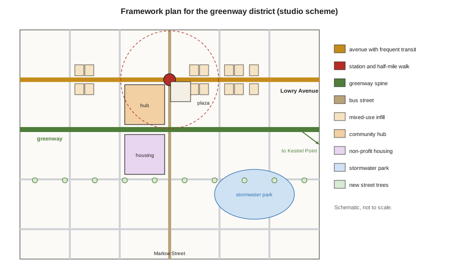
The structure plan has four layers.
- Movement: the avenue becomes a complete street with frequent buses, bus bulbs, protected bicycle lanes and a signalized crossing at the hub corner. Two streets closed by the lumber yard are reopened. Four new crossings of the greenway connect the streets north and south of it, cutting Ingrid's nine-minute walk to three. Marlow Street becomes a green street.
- Open space: the greenway is the spine, planted as a habitat corridor with a groomed winter path and a ski track. The plaza at the hub corner is the district's front room. The stormwater park on the rail yard holds the district's largest storms, with a wetland, meadow, sliding hill and daylighted creek. Every home is within a quarter mile of a park or the greenway.
- Built form: six-story mixed-use buildings near the corner, four to five stories along the rest of the avenue and on the large sites, and gentle infill of up to four homes per lot on the residential streets. Every building facing the avenue, a park or the greenway has doors and windows on that face.
- Land use: homes for many incomes everywhere; shops and services on the avenue and around the plaza; workshops and small offices in the rail yard buildings nearest the avenue; civic uses at the hub and the school.
The students summarize the framework's numbers.
# Framework plan summary for the greenway district
homes_now, homes_new = 4800, 2600
jobs_now, jobs_new = 2100, 1500
pph = 2.2
park = 23.5                   # new and improved public open space, acres
canopy_from, canopy_to = 0.17, 0.30
impervious_from, impervious_to = 0.62, 0.51
people = (homes_now + homes_new) * pph
print(f"homes {homes_now:,} -> {homes_now + homes_new:,} (+{homes_new / homes_now:.0%}); "
      f"jobs {jobs_now:,} -> {jobs_now + jobs_new:,}")
print(f"open space per resident: {park * 43560 / people:.1f} ft2")
print(f"canopy {canopy_from:.0%} -> {canopy_to:.0%}; impervious {impervious_from:.0%} -> {impervious_to:.0%}")
affordable = 780
print(f"below-market share of new homes: {affordable / homes_new:.0%} ({affordable:,} homes)")homes 4,800 -> 7,400 (+54%); jobs 2,100 -> 3,600 open space per resident: 62.9 ft2 canopy 17% -> 30%; impervious 62% -> 51% below-market share of new homes: 30% (780 homes)
Over about twenty-five years, the framework adds 2,600 homes, an increase of more than half, and 1,500 jobs, mostly along the avenue and on the two large sites. It raises tree canopy from 17% to 30% and cuts impervious surface from 62% to 51%. It adds or improves about 23.5 acres of public open space. And it commits 30% of new homes, 780 in all, to below-market rents, most of them built early on public and non-profit land.
Key sites
Each student presents a key site in more detail.
- Wren presents the greenway itself: a 1.5-mile linear park with a sequence of spaces, from a sunny plaza at the avenue to a bridge over the rail yard wetland and a lookout at Kestrel Point. Her section shows the winter path, the ski track, the planted swales and the frontages of the new buildings facing it.
- Callum presents the avenue: a series of sections showing the complete street, the six-story buildings with their tall ground floors and stepbacks, and the angular plane that protects the houses on the lane behind. His shadow study shows that the sidewalk on the north side of the avenue is in sun at midday from February to October.
- Ingrid presents the rail yard: 10 acres of stormwater park and about 15 acres of new blocks with about 900 homes, half of them below market, built in phases by Greenway Homes, a community land trust and private developers under a development agreement with the city.
- Joon-ho presents the hub corner: the plaza, the bus stops, the youth court under the canopy, the café, the warm waiting room in the hub and the crossing, with a winter evening perspective showing the lights, the steam from the café and the skaters.
The review
The critics' questions show what a real review of a district framework involves.
Natarajan asks how the city will pay for the rail yard, the park and the avenue. The students have prepared a funding table: the land purchase from the city's land fund, to be repaid partly by selling development parcels; the park partly from stormwater fees and state and federal climate funds; the avenue from the transit and street renewal budgets. She is not fully convinced by the timing of the land sales, and asks them to show a slower scenario.
Sadeghi asks whether the densities are high enough to justify ten-minute service, and whether the other stops on the avenue will grow too. The students show that their walkshed density nearly quadruples but admit that the line as a whole depends on the city planning the other station areas in the same way. He suggests that they say so explicitly as a condition.
Lafontaine asks how many of the households on Aldous Street today are likely to still be there in fifteen years. The students cannot answer with a number, but they present the phasing table and the monitoring measure from Lesson 11. She asks them to add a target and to say what will happen if it is missed.
Kowalchuk says he still worries about parking on his street when the apartment buildings are full, and the students show him the parking study: a shared structure behind the avenue, permit parking on residential streets if needed, and car share at the plaza. He says he will believe it when he sees it, then admits that the skate court was a good idea.
Okonkwo has the last word. 'Two years ago you designed one building on this corner,' he says. 'Now you've designed the conditions for a thousand buildings you will never see. The test of a framework is not whether it looks good on these boards. It's whether a mediocre architect, a cautious developer and a busy planner, following its rules, will produce a place that's better than what they would have made without it. I think yours would. Write the rules a little tighter on the avenue, and be more honest about the money.'
After the review
The students spend the following week revising the framework. Callum tightens the avenue rules: the build-to line is fixed rather than a range, the minimum ground-floor height applies to every building on the avenue whatever its use, and blank walls facing the greenway are limited to 20 ft. Ingrid adds a slower land-sale scenario to the funding table, which shows that the park would be completed four years later than planned unless the city adds money from its capital budget; the framework now says so and names the decision council will have to make. Joon-ho writes the transit condition into the vision's supporting text: frequent service is a commitment from the city, and the growth that justifies it is a commitment from the district and the other station areas, to be reviewed together every five years. Wren adds Lafontaine's target, that at least 70% of the households present at the start still live in the district after five years, and a list of actions if it is missed.
In their reflections, each student writes about what surprised them. For Wren it was how much of the district's future depended on who owned the land. For Callum it was that the most useful drawing he made all term was a section through a sidewalk in January. For Ingrid it was that a stormwater engineer and a tenants' organizer had more influence on the plan than any architect. Joon-ho wrote one line, which Desrosiers pinned to the studio wall: 'The district was already designed. We just changed the rules a little and tried to make sure the people who live there could stay to see it.'
Preparing your own framework
The course project asks each student or team to prepare a framework plan for a district in their own city, following the steps of this course.
- Lesson 1: define the district by walking it and mapping a ten-minute walk from a center.
- Lesson 2: research its history and the decisions that shaped it.
- Lesson 3: analyze its streets and blocks, and propose new connections and street sections.
- Lesson 4: study its public spaces with counts and observation, and redesign one.
- Lesson 5: test density and form on key sites, with shadow studies.
- Lesson 6: plan its station area or transit corridor.
- Lesson 7: read its landscape and set grading, planting and canopy strategies.
- Lesson 8: map its water and design a green infrastructure system.
- Lesson 9: identify the plans and rules that apply and write the changes needed.
- Lesson 10: design and, if possible, carry out an engagement process.
- Lesson 11: audit its equity and propose protections and phasing.
- Lesson 12: combine everything into a vision, principles, structure plan, key sites, guidelines, phasing and monitoring, and present it.
Present the framework on no more than eight boards, with at least one section and one eye-level view for every major idea, a table of numbers, a phasing diagram and a one-page summary in plain language that a resident could read in five minutes.
Exercise 12: final framework
- Write a vision of no more than sixty words and five to eight principles for your district.
- Draw the structure plan in four layers: movement, open space, built form and land use.
- Develop two key sites with test designs and sections.
- Summarize the framework's numbers: homes, jobs, open space per resident, canopy, impervious surface, affordable homes.
- Prepare a phasing and funding table and a monitoring plan with at least three measurable targets.
Communicating the framework
Okonkwo spends a few minutes after the review on presentation itself. The strongest boards, he says, were the ones that showed a single idea clearly: Wren's long section through the greenway, Joon-ho's winter evening view of the plaza and Callum's sequence of avenue sections from today to twenty-five years from now. The weakest board tried to show everything at once. A framework has many audiences: council members who will vote on it, residents who will live with it, developers who will build under it and future planners who will interpret it when the students are long gone. Each needs a different entry point. He recommends a one-page summary with a map and the principles, a short illustrated document for the public, the full framework for the city, and a set of key drawings that can be reused in later meetings without explanation.
Common mistakes
MistakePresenting a beautiful plan with no route to delivery.
InsteadShow who builds each part, when, with what money and under what rules.
MistakeDesigning every building in the district.
InsteadSet the structure and rules, and test them with a few key sites.
MistakeLeaving the numbers vague.
InsteadQuantify homes, jobs, open space, canopy, runoff and affordability.
MistakeIgnoring the risks.
InsteadState the conditions the plan depends on and what happens if they are not met.
MistakeWriting the summary for designers only.
InsteadWrite a plain-language summary residents can read in five minutes.
Summary and key terms
- A framework plan contains a vision, principles, a layered structure plan, key sites, guidelines, phasing, implementation and monitoring.
- The greenway framework links transit, public space, landscape, water, density and equity around a green spine.
- Numbers make a framework testable: homes, jobs, open space, canopy, impervious surface and affordable homes.
- Key site studies test whether the rules produce good places.
- A real review probes funding, transit conditions, displacement and everyday concerns such as parking.
- The test of a framework is whether ordinary projects following its rules make a better place.
- Vision
- A short statement of what a place should become over the long term.
- Structure plan
- A plan of the long-term framework of movement, open space, built form and land use.
- Key site
- A large or strategic site studied in detail to test a framework's rules.
- Phasing
- The order and timing in which parts of a plan are built.
- Monitoring
- Tracking measurable indicators to see whether a plan is achieving its goals.
- Development agreement
- A contract between a city and a developer setting out obligations for a site.
Practice problems
Work each problem on paper first, then reveal the answer to check.
Using the code output, by what share does the number of homes grow?
Show answer
By about 54%, from 4,800 to 7,400.
Name the four layers of a structure plan.
Show answer
Movement, open space, built form and land use.
Why test a framework with key site designs?
Show answer
To check that buildings following the rules produce good streets and spaces, and that the rules can be met at reasonable cost.
Give an example of a measurable monitoring target for equity.
Show answer
For example, at least 70% of households present at the start still living in the district after five years.
What did Okonkwo say is the real test of a framework?
Show answer
Whether ordinary projects following its rules produce a better place than they would have without it.
Lesson quiz · 5 questions
Score 60% or more to complete this lesson.
Create a free account to save your progress, take quizzes and earn a certificate.