
ARCH-340 · Lesson 7 of 12 · 18 min
Landscape architecture principles
Desrosiers takes the class to the greenway on a bright March afternoon when the snow is starting to melt. Water is running down the rail embankment and pooling in a low spot where the path crosses a culvert; the path is under 4 in of slush. Fifty meters on, a line of old elms casts a lattice of shadows across a dry, sunny stretch where two people are walking a dog. Beyond them, a patch of tall dry grass and seed heads stands out against the snow. 'Everything you see here,' she says, 'is landscape architecture or the lack of it: where water goes, where the sun falls, what grows and what it does for people and animals. Architects tend to think of landscape as what is left after the building. Landscape architects start with the ground, the water and the living things, and fit the buildings in. In a district plan, you need to think like both.'
The profession and its roots
Landscape architecture is the design of outdoor spaces, from gardens and plazas to parks, campuses, streets, waterfronts and regional systems of green space. It combines design, ecology, horticulture, engineering and an understanding of how people use places. The term was adopted by Frederick Law Olmsted and Calvert Vaux, whose design for Central Park in New York won the competition of 1858. Olmsted went on to design parks and park systems across North America, including park systems in Boston and Buffalo. In Minneapolis, Horace Cleveland's plan of 1883 and the long tenure of parks superintendent Theodore Wirth produced the Grand Rounds, a chain of parkways around lakes and along the Mississippi and Minnehaha Creek.
In the twentieth century landscape architects shaped suburbs, highways, campuses and modernist plazas. Ian McHarg's Design with Nature (1969) introduced a method of overlaying maps of soils, slopes, water, vegetation and habitats to find where development should and should not go, laying the groundwork for today's environmental planning and geographic information systems. Since the 1990s, landscape urbanism has argued that landscape, more than buildings, can be the organizing structure of a city, and projects such as the High Line in New York and the reclaimed waterfronts of many cities have shown what that can mean.
Reading the site
Landscape design begins with careful reading of the site, much as the students did for the hub in ARCH-200, but at a larger scale and with more attention to living systems.
- Landform: the shape of the ground, its high and low points, slopes and drainage divides.
- Hydrology: where water comes from, where it flows on the surface and below, where it pools, and where it floods in spring melt or heavy storms.
- Soils: their texture, depth, drainage and contamination. The greenway district sits on the clay of an old glacial lake bed, which drains slowly, swells when wet and shrinks when dry.
- Microclimate: sun and shade through the seasons, prevailing winds, cold pockets and snow drifts.
- Vegetation: existing trees, their species, size, health and value, and remnants of native plant communities.
- Habitat: which birds, insects and animals use the site, and how it connects to larger natural areas.
- Human use: desire lines, views, noise and the places people already gather.
On the greenway, the students map all of these. The rail embankment is a ridge about 5 ft above the surrounding streets, which explains why water runs off it into the backyards and the culvert. The old elms are American elms, part of one of the largest remaining populations of this species in North America ; Minneapolis lost most of its elms to Dutch elm disease from the 1970s and replanted with a wider mix. The patch of tall grass is a remnant of tallgrass prairie that survived along the rail line because the railway burned the right of way, imitating the fires that once maintained the prairie.
Landform and grading
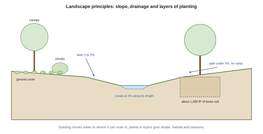
Grading is the shaping of the ground. It decides where water goes, whether paths are accessible, how spaces are enclosed and how much soil must be moved. Slopes are described in % (the rise divided by the run, times 100) or as a ratio of horizontal to vertical distance.
| Use | Typical slope |
|---|---|
| Lawn and play areas, to drain without puddles | 2 to 5% |
| Hard paving for drainage | at least 1 to 2% |
| Accessible walk without handrails | up to 5% |
| Ramp (with handrails and landings) | up to 8.33% (1 in 12) |
| Grassed swale along its length | about 1 to 4% |
| Mown grass bank | up to about 33% (3:1) |
| Planted bank, not mown | up to about 50% (2:1) |
Good grading balances cut and fill on site where possible, keeps water away from buildings and toward places where it can soak in or be stored, and makes the landform part of the design. A low mound can shelter a seating area from the wind, give children a sliding hill and hide a utility box; a gentle bowl can hold storm water and be a lawn in dry weather.
The students check the greenway path where it crosses the embankment, and estimate how much of the district would need new trees to reach a canopy target.
import math
# Grading and canopy checks for a park edge
rise, run = 3, 80          # ft
slope = rise / run
print(f"slope {slope:.1%}: " + ("accessible walk" if slope <= 0.05 else "needs a ramp or a longer route"))
# Tree canopy target for the district
district = 21500000                  # ft2
canopy_now = 3655000                 # ft2 of canopy today
target = 0.30
crown = 540                    # mature crown area of one street tree, ft2
need = max(0, target * district - canopy_now)
trees = math.ceil(need / crown)
print(f"canopy now {canopy_now / district:.0%}; to reach {target:.0%} plant about {trees:,} trees")
# Soil volume rule of thumb: about 2 ft3 of uncompacted soil per ft2 of mature crown
soil = crown * 1 * 2
print(f"soil per tree: about {soil:,.0f} ft3")slope 3.8%: accessible walk canopy now 17%; to reach 30% plant about 5,176 trees soil per tree: about 1,080 ft3
The path rises 3 ft over 80 ft, under 5%, so it can be accessible without a ramp if it has level resting places. The canopy target is more demanding: about 5,200 trees, planted along streets, in parks and in yards over many years. And each tree needs a large volume of soil to grow to maturity, far more than the small pits typical of downtown sidewalks.
Planting design
Planting is the most distinctive tool of landscape architecture, and the one architects most often get wrong. Plants are living, growing, changing and dying; their size at maturity may be ten times their size at planting; they need the right soil, water, light and climate; and they need care.
- Layers: a planting is usually designed in layers: canopy trees, understory trees, shrubs, ground covers and bulbs. Layered planting gives shade, habitat, visual depth and interest in every season.
- Hardiness: plants must survive the coldest winters. Minneapolis is in USDA hardiness zone 4b to 5a, with winter lows that can fall below −25 °F. Species that thrive in milder cities fail here.
- Native and adapted species: native plants support native insects and birds and are adapted to local soils and climate. Prairie grasses and wildflowers, bur oak, green ash (now threatened), hackberry, basswood and native shrubs are the backbone of prairie planting.
- Diversity: monocultures are vulnerable. A common rule for urban forests, the 10-20-30 rule proposed by Frank Santamour in 1990, suggests no more than 10% of trees of any one species, 20% of any genus and 30% of any family. The loss of elms to Dutch elm disease, and now of ashes to the emerald ash borer, found in Minneapolis in 2010, shows why.
- Seasons: in a northern city, design for winter as carefully as summer: evergreen shelter, bark and branch structure, seed heads, berries for birds, and plants that hold snow attractively.
- Maintenance: every planting needs a maintenance plan and budget. A meadow needs mowing or burning once a year; a perennial bed needs weeding; young trees need watering for two to three years.
Trees in the city
Urban trees provide shade, cooling, stormwater interception, habitat, wind shelter and beauty, and studies have linked them to lower summer temperatures, better health and higher property values. Yet street trees often live far shorter lives than trees in parks, because they are planted in small pits of compacted soil surrounded by paving, salted in winter, hit by plows and starved of water. Researchers and practitioners, notably the landscape architect James Urban, have shown that trees need large volumes of uncompacted soil, roughly 2 ft³ of soil per ft² of the mature crown, which means continuous soil trenches or soil cells under sidewalks rather than isolated pits.
For the greenway district, the students set a canopy target of 30%, up from about 17% today. Their tree strategy includes: protecting the elms and the bur oak at the hub; planting large-canopy species along the avenue in continuous soil trenches with soil cells under the widened sidewalks; using salt-tolerant species near the avenue and directing salty meltwater away from tree roots; diversifying species to follow the 10-20-30 rule; and planting a small forest on the clay of the old rail yard, where a stormwater park will go (Lesson 8).
Snow as a landscape material
In a prairie city, snow covers the ground for four or five months, and a landscape designed only for summer is a landscape that fails for nearly half the year. Snow is heavy, it drifts, it melts in spring all at once, and it carries salt, sand and litter from the streets. It is also a material to design with. Fences, hedges and berms placed upwind of a path cause drifts to form on their downwind side, keeping the path clear; the drift typically forms within a distance of about ten to fifteen times the height of the barrier, so a living snow fence of shrubs is planted well back from the route it protects. Snow storage areas should be lawn or planted beds that can take the weight and the salt and that drain away from buildings when the snow melts. Spring melt is the season of greatest runoff in many prairie cities, when frozen ground cannot absorb water, so swales and low areas must be graded to carry the melt even when they are still frozen.
Snow is also a source of play and beauty. A sliding hill, a skating loop, a lit row of birches against snow, the blue shadows of a winter afternoon and the tracks of animals across a meadow are among the pleasures of a northern landscape. Wren proposes leaving one stretch of the greenway unplowed as a cross-country ski track, with a groomed walking path beside it, and Callum suggests grading the stormwater park so that its slopes become the district's toboggan run.
Ecology and connection
Landscape ecologists describe landscapes as patches (areas of habitat), corridors (linear connections) and the matrix (the surrounding land). Wildlife and plants move along corridors between patches. In cities, rivers, ravines, rail lines and greenways often form the corridors. The greenway is such a corridor: it links the district to the lake at Kestrel Point and could, with better planting, carry pollinators, birds and small mammals between the lake shore and the parks of the district.
Ecology also includes people. Landscapes that let people see, touch and care for living things, such as community gardens, schoolyard forests and naturalized parks, build attachment to place. Desrosiers asks the students to design the greenway as both a habitat corridor and a social corridor: a place where neighbors walk dogs, children ride bikes, older people sit and someone, every spring, burns the prairie patch under the supervision of the city's naturalist.
Exercise 7: landscape analysis
- Map landform, drainage, soils, microclimate, existing trees and human use for a park or greenway in your district.
- Draw a section showing slopes and where water goes; check that paths meet accessible slopes.
- Measure the tree canopy cover of your district from an aerial photograph and estimate the trees needed to reach 30%.
- Design a planting plan for a 65 ft stretch of street with layered, diverse, hardy species and a soil strategy.
- Write a one-page maintenance plan for your planting.
Common mistakes
MistakeTreating landscape as what is left after the buildings are placed.
InsteadStart with landform, water, soils and vegetation, and fit buildings to them.
MistakeDrawing trees at their mature size in small pits.
InsteadProvide enough uncompacted soil for the trees to reach that size.
MistakePlanting a single species along a whole street.
InsteadDiversify species and genera to resist pests and diseases.
MistakeChoosing plants from milder climates.
InsteadUse hardy native and adapted species suited to the local zone.
MistakeDesigning a planting without a maintenance plan.
InsteadSpecify who will care for it, how and with what budget.
Summary and key terms
- Landscape architecture designs outdoor spaces from gardens to regional systems, combining design, ecology and engineering.
- Site reading covers landform, hydrology, soils, microclimate, vegetation, habitat and human use.
- Grading directs water, makes paths accessible and shapes space; common slope ranges guide early design.
- Planting works in layers and must be hardy, diverse, suited to the seasons and maintained.
- Urban trees need large volumes of uncompacted soil to thrive.
- Greenways and rivers can act as corridors linking habitats and people.
- Grading
- Shaping the ground to direct water, set slopes and form spaces.
- Swale
- A shallow, broad channel, usually grassed or planted, that carries and slows water.
- Hardiness zone
- A region defined by its winter temperatures, used to choose plants that will survive.
- Tree canopy cover
- The share of land covered by tree crowns when seen from above.
- Soil cell
- A structural frame placed under paving that holds uncompacted soil for tree roots.
- Habitat corridor
- A linear strip of habitat that lets plants and animals move between larger areas.
Practice problems
Work each problem on paper first, then reveal the answer to check.
A path rises 4 ft over 66 ft. Is it accessible without a ramp?
Show answer
No: the slope is about 6%, above 5%; lengthen the path or add a ramp with landings.
Why do street trees in small pits often die young?
Show answer
Compacted soil, too little soil volume, salt, damage and lack of water.
State the 10-20-30 rule.
Show answer
No more than 10% of trees of one species, 20% of one genus and 30% of one family.
Name three layers of a planting design.
Show answer
Canopy trees, shrubs and ground covers (understory trees and bulbs also count).
What is the role of a habitat corridor in a city?
Show answer
It connects patches of habitat so plants and animals can move between them.
Lesson quiz · 5 questions
Score 60% or more to complete this lesson.
Create a free account to save your progress, take quizzes and earn a certificate.