
ARCH-340 · Lesson 1 of 12 · 21 min
The scale of urban design
The first class of the term does not meet in the studio. Professor Hélène Desrosiers asks the four students to meet her at the bus stop on the corner of Lowry Avenue and Marlow Street, beside the community hub they designed in ARCH-200, at eight in the morning in late January. She hands each of them a clipboard, a stopwatch and a printed map with a circle on it, and asks them to walk for ten minutes in any direction they like, then turn around and come back, recording what they pass. Wren heads west along the greenway toward the old rail bridge; Callum walks north across the avenue, past the school, into a street of small houses; Ingrid follows Marlow Street south past the old lumber yard where Greenway Homes will build the housing they designed in ARCH-201; Joon-ho walks east along the avenue toward the shops. When they return, cold and pink, she asks them to put their four routes on one map. Together they have drawn a rough cross about a mile long. 'That,' she says, 'is the district. Not a line on a zoning map, not a ward, not a census tract. The area that a person can reach on foot in about ten minutes. Everything this term happens at that scale, and at the scales just above and below it.'
Desrosiers is a landscape architect and urban designer. She spent twelve years in a city planning department, where she wrote design guidelines for main streets and led the public process for a riverbank park, and eight years in a practice that designs streets, plazas and stormwater landscapes. She tells the students on that first morning that urban design is not a separate profession so much as a way of working: architects, landscape architects, planners and engineers all practice it when they think about what happens between buildings. This course gives them the vocabulary, the methods and some of the numbers they need to take part.
What urban design is
Urban design is the design of the public realm and of the relationships between buildings, streets, open spaces, landscapes and the people who use them. It deals with the form of districts, streets and blocks; with the location, size and edges of public spaces; with how buildings meet the ground and the sidewalk; and with how all of this changes over time. It works through drawings and models, as architecture does, but also through plans, policies, codes, budgets and public conversations, because the urban designer rarely controls a whole place. Most of a city is built one lot at a time by many owners over many decades.
Three features distinguish urban design from the design of a single building. First, the client is plural. A neighborhood has residents, owners, businesses, institutions, transit agencies and future residents who do not yet live there, and their interests differ. Second, the time frame is long. Streets laid out in the nineteenth century still shape where people walk today, and a district plan may take thirty years to build. Third, the designer works through others. A framework plan sets out where streets, parks and taller buildings should go, but each building will be designed by someone else. The urban designer's skill is to make rules and drawings that guide many hands toward a coherent result without dictating every detail.
Desrosiers offers a working definition that the students copy into their notebooks: urban design arranges the shared parts of a place so that the private parts add up to something better than their sum.
A hierarchy of scales
Urban designers move constantly between scales. A useful hierarchy has five levels, each nested inside the next.
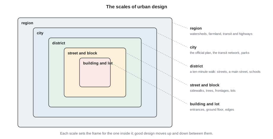
- The region is the scale of river basins, farmland, commuter sheds, highways and regional transit. The Twin Cities region is governed in part by the Metropolitan Council, which plans regional transit, sewers and parks for seven counties around the two downtowns. Regional decisions decide where growth can go at all.
- The city is the scale of the official plan, the street network, the transit system, the parks system and the zoning by-law. Minneapolis 2040, the city's comprehensive plan, sets out where growth should go, what kind of buildings are allowed in each area and how the city will meet its goals for housing, climate and equity.
- The district is the scale of a ten-minute walk, roughly half a mile from a center, or about 500 acres. It is large enough to support a main street, an elementary school, a park and a frequent bus or rail stop, and small enough to know on foot. Neighborhoods, station areas and downtown precincts are districts.
- The street and block is the scale of a single street from building face to building face, and of the lots and frontages along it: sidewalks, trees, curbs, lanes, parking, entrances, front yards and fences.
- The building and lot is the scale of a single project: how it meets the sidewalk, where its doors are, what its ground floor contains, how it shades its neighbors and what it does with its edges.
The point of the hierarchy is that decisions made at one scale constrain the scales inside it. A regional decision to build a highway along a river determines where a district can reach the water. A city decision to put a frequent bus line on an avenue determines where a district's main street will be. A district decision to keep blocks short determines how many corners each building gets. Good urban design moves up and down: Desrosiers calls it 'zooming in to check that the big idea works for one person on one sidewalk, and zooming out to check that the small idea adds up to a place'.
The district as the unit of design
The course's project is a framework plan for the district the students walked on the first morning: the area within about half a mile of the corner of the avenue and Marlow Street. It contains the community hub, the Greenway Homes site, the greenway along the old rail line that leads to Kestrel Point, a strip of shops along the avenue, two schools, two churches, several thousand houses, a closed lumber yard, a rail yard that is mostly empty and a large area of parking lots and low industrial buildings to the south-east. The city has proposed frequent bus service on the avenue with a new stop at the hub corner, which turns the corner into something like a station.
Why the district? Because it is the scale at which many daily needs can be met on foot, and because it is the scale at which the public realm of streets, parks and public buildings can be designed as one system. The planning idea of the neighborhood unit, proposed by Clarence Perry in the 1920s, organized a district around an elementary school within a short walk of every home, with shops at the edges and through traffic kept to the boundary roads. Much later the idea of the fifteen-minute city, popularized by Carlos Moreno around 2016 and taken up by Paris during the pandemic, asked whether most daily needs could be reached within a fifteen-minute walk or bicycle ride. Both ideas treat the walkable district as the basic building block of a city.
The students test the numbers for themselves. How many people live at each scale, and how long does it take to walk across it?
# People and homes at different scales of urban design
scales = [  # name, area in acres, homes per acres
    ("one block", 3, 24),
    ("walkable district", 500, 8),
    ("whole city", 37300, 5.4),
]
people_per_home = 2.2
for name, area, density in scales:
    homes = area * density
    people = homes * people_per_home
    print(f"{name:<18} {area:>10,.1f} acres  {homes:>9,.0f} homes  {people:>9,.0f} people")
# How far is it to walk across each one?
for name, area, _ in scales:
    side = (area * 43560) ** 0.5          # side of a square of the same area, in ft
    minutes = side / 260                # walking speed in ft per minute
print(f"{name:<18} about {side:,.0f} ft across, {minutes:,.1f} minutes on foot")one block 3.0 acres 72 homes 158 people walkable district 500.0 acres 4,000 homes 8,800 people whole city 37,300.0 acres 201,420 homes 443,124 people one block about 361 ft across, 1.4 minutes on foot walkable district about 4,667 ft across, 17.9 minutes on foot whole city about 40,309 ft across, 155.0 minutes on foot
Desrosiers points out three things. The block is small enough to cross in a minute or two, which is why its design is about edges and entrances more than distances. The district takes about a quarter of an hour to cross corner to corner, which is why a single center, such as a station or a main street, can serve all of it. The city cannot be crossed on foot in any practical sense, which is why it needs a transit network. The homes per acre across the whole city are rough averages that include parks, lakes, rail yards and industrial land; they are used only for comparison.
Who shapes a district
A district is shaped by many actors, most of whom never meet. The students list them for the greenway district.
- Public bodies: the city's planning, public works, transit, parks and water departments; the school division; the state, which funds transit and sets planning law; and, the Metropolitan Council, which runs regional transit and plans regional parks.
- Private owners: homeowners, landlords, the lumber yard's owner, the shopkeepers on the avenue, the rail company that owns the yard, and developers who might buy land.
- Non-profit and community bodies: Greenway Homes, the neighborhood association that Ernest Kowalchuk chairs, the churches, the daycare that Rita Moreau directs, and a tenants' group that has started meeting in the hub's community room.
- Designers: architects of individual buildings, landscape architects of parks and streets, engineers of roads, sewers and bridges, and urban designers who try to coordinate them.
No one in the list has authority over the whole district, and each acts on a different timetable. A framework plan is valuable precisely because it gives these actors a shared picture they can each work toward.
Tools of urban design
Urban designers work with a particular set of drawings and studies. The students will produce all of them for the greenway district by the end of the term.
- Figure-ground plans, in which buildings are black and everything else is white, reveal the grain of a place: how big its buildings are, how continuous its street walls are and where it is open.
- Street network maps show how well connected a district is: where streets go through, where they stop and how far apart the intersections are.
- Land use and activity maps show where people live, work, shop, learn and play, and what is open at night.
- Sections through streets and open spaces show the relationship between building height and street width, and how the space is divided between walking, cycling, trees, parking and driving.
- Massing models and three-dimensional views test how much building a district could hold and what it would feel like at eye level.
- Observation studies, in the tradition of William Whyte and Jan Gehl, count how many people walk, sit, stand and play in a space at different times.
- Framework plans and design guidelines set out the big moves (streets, parks, landmarks, densities) and the rules that individual buildings should follow.
Desrosiers adds a warning about drawings. A plan seen from above makes every space look equally important and every street look easy to cross. People experience places from about 5 ft 3 in above the ground, at walking speed, in weather. Every plan drawing in this course must be checked with at least one eye-level view or section.
Time and change
A building is designed, built and then occupied. A district is never finished. Its streets may last for centuries; its trees for decades; its buildings for anywhere from twenty years to two hundred; its shops and uses for a few years. Urban designers therefore think about which elements should be permanent and which should be free to change. The street pattern and the public spaces are the long-lived bones of a place and deserve the most care. Buildings fill in the spaces between and change more often. Uses inside the buildings change most often of all.
This layering explains why old districts can feel richer than new ones built all at once. Minneapolis's North Loop and Warehouse District was built in a few decades around 1900 but has been adapted many times since, from warehouses to offices, shops, studios and homes, because its streets, blocks and solid buildings were robust enough to hold new uses. A new district should plan for the same kind of change, leaving room for buildings not yet imagined.
Exercise 1: walking the district
- Walk for ten minutes in four directions from a transit stop near you. Record the time, distance and everything you pass: buildings, uses, crossings, trees, places to sit, barriers.
- Draw the four routes on one map at a scale of 1 in = 400 ft. Mark where walking was pleasant and where it was difficult or unsafe.
- Draw a figure-ground of the area within a quarter mile of the stop. Describe the grain in three sentences.
- List the public bodies, private owners, community groups and designers who shape the area.
- Identify three elements you think will still be there in a hundred years, and three that will probably change in the next ten.
Common mistakes
MistakeTreating urban design as large-scale architecture with one client and one design.
InsteadDesign rules, frameworks and public spaces that guide many owners and designers over many years.
MistakeWorking only in plan.
InsteadCheck every plan with sections and eye-level views, at walking speed and in winter.
MistakeDrawing the district boundary as a neat circle and stopping there.
InsteadLook at what is just outside: highways, rivers, rail lines and edges shape a district as much as its center.
MistakeDesigning everything to be finished at once.
InsteadDistinguish the long-lived bones (streets, parks) from the parts that should be free to change.
MistakeAssuming the plan will be built because it is drawn.
InsteadIdentify who will build each part, with what money and under what rules.
Summary and key terms
- Urban design arranges the shared parts of a place: streets, open spaces, landscapes and the relationships between buildings.
- It differs from building design in having many clients, a long time frame and many designers working through rules and frameworks.
- Five nested scales matter: region, city, district, street and block, and building and lot; decisions at each frame the next.
- The walkable district, about a ten-minute walk across, is the basic unit of design and the subject of this course's project.
- Figure-grounds, network maps, sections, massing models, observation studies and framework plans are the main tools.
- Streets and public spaces are the long-lived bones of a place; buildings and uses change more often.
- Public realm
- The streets, sidewalks, parks, plazas and other spaces that are open to everyone, together with the building faces that frame them.
- District
- An area of roughly a ten-minute walk across, large enough for a main street, a school and a transit stop.
- Figure-ground
- A plan drawing in which buildings are solid and open space is blank, showing the grain of a place.
- Framework plan
- A plan that sets out the main streets, open spaces, densities and rules for a district without designing every building.
- Neighborhood unit
- Clarence Perry's 1920s model of a district organized around an elementary school within walking distance.
- Fifteen-minute city
- The idea that most daily needs should be reachable within a fifteen-minute walk or bicycle ride.
Practice problems
Work each problem on paper first, then reveal the answer to check.
Using the code output, roughly how long does it take to walk across the district?
Show answer
About 18 minutes for a square of the same area; a circle of half a mile radius is about 20 minutes across through the center.
Name two decisions made at the city scale that shape the greenway district.
Show answer
For example, putting frequent transit on the avenue and the zoning that applies to the lumber yard.
Why is a figure-ground drawing useful?
Show answer
It shows the grain of a place: the size of buildings, the continuity of street walls and where it is open.
Give one example of a long-lived element and one short-lived element in a district.
Show answer
Street pattern (long-lived); the uses of ground-floor shops (short-lived).
Why must a plan drawing be checked with a section or eye-level view?
Show answer
Because people experience places from eye height at walking speed, where heights, widths and edges matter more than plan shapes.
Lesson quiz · 5 questions
Score 60% or more to complete this lesson.
Create a free account to save your progress, take quizzes and earn a certificate.