
ARCH-340 · Lesson 3 of 12 · 21 min
Streets and blocks
Ingrid has volunteered to time the walk from the front door of a house on the south side of the greenway to the bus stop at the hub corner. The bus stop is only 850 ft away in a straight line, but the walk takes her nine minutes. The house is on a street that ends at the old lumber yard fence; to reach the avenue she has to walk two blocks east to Marlow Street, cross the greenway at the only crossing for half a mile, then walk back west. Desrosiers asks the class to imagine making that walk with a stroller, in January, after dark. 'The distance between two points in a city,' she says, 'is not the distance on the map. It is the distance along the streets, and how those streets feel. This lesson is about streets and the blocks they make.'
Streets as public space
Streets are the largest public space in any city, typically between a quarter and a third of urban land. They carry people, goods, water, power and data; they give buildings their addresses and their light; and they are where most public life happens. For most of the twentieth century, North American street design treated streets mainly as channels for moving vehicles, sizing them for peak traffic and judging them by how fast cars could travel. Since about 2000 a broader view has taken hold. A street is now expected to serve walking, cycling, transit, deliveries, trees, stormwater, snow storage and social life as well as driving.
Two terms are worth distinguishing. Mobility is the ability to travel quickly over distance; access is the ability to reach destinations. A highway gives mobility but little access: you cannot stop at a shop on it. A main street gives access but limited mobility. Good networks provide both, with a hierarchy of streets: a few arterials and transit corridors that carry through traffic, many local streets that give access, and connections fine enough that people can walk directly to where they want to go.
Blocks: size and connectivity
A block is the land bounded by streets. Block size determines how many routes a pedestrian has, how many corners and frontages a district has, and how easily the district can change over time. Small blocks, roughly 200 to 400 ft on a side, create many intersections, short walks and many corner sites for shops. Large blocks or superblocks, sometimes 1,000 ft or more on a side, force long detours and concentrate traffic on fewer streets. Cul-de-sac layouts, common in postwar suburbs, minimize through traffic on local streets but make walking trips much longer because the network has few connections.
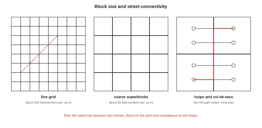
Planners measure connectivity in several ways. Intersection density counts intersections per unit area; a fine grid typically has several hundred per square mile, while cul-de-sac suburbs may have a fraction of that. Block perimeter, the distance around a block, measures how far a pedestrian may have to walk to get around it. Route directness compares the distance along the network with the straight-line distance between two points; a ratio near 1.2 is good, and ratios of 2 or more, as in Ingrid's walk, are poor.
The most telling measure is the walkshed: the area that can be reached within a given walking distance along the streets. The students compare the walkshed around a central point on a connected grid with the walkshed on a network of collectors and dead-end local streets, using the same spacing between intersections and the same half-mile limit.
# Walkshed on a street network: grid versus loops and cul-de-sacs
from collections import deque
N, step = 21, 330          # 21 x 21 nodes, 330 ft between nodes
limit = 2640               # walking limit along streets, ft
def grid_edges(n):
    e = set()
    for i in range(n):
        for j in range(n):
            if i + 1 < n: e.add(((i, j), (i + 1, j)))
            if j + 1 < n: e.add(((i, j), (i, j + 1)))
    return e
def suburban_edges(n):
    # keep a collector every 5th row and column; local streets are dead ends off the collectors
    e = set()
    for (a, b) in grid_edges(n):
        (i1, j1), (i2, j2) = a, b
        collector = (i1 == i2 and i1 % 5 == 0) or (j1 == j2 and j1 % 5 == 0)
        local_spur = (j1 == j2 and j1 % 5 != 0 and i1 % 5 != 4)
        if collector or local_spur:
            e.add((a, b))
    return e
def reach(edges, start):
    adj = {}
    for a, b in edges:
        adj.setdefault(a, []).append(b); adj.setdefault(b, []).append(a)
    dist = {start: 0}; q = deque([start])
    while q:
        u = q.popleft()
        for v in adj.get(u, []):
            if v not in dist:
                dist[v] = dist[u] + step; q.append(v)
    return sum(1 for d in dist.values() if d <= limit)
c = (N // 2, N // 2)
for name, edges in (("connected grid", grid_edges(N)), ("loops and cul-de-sacs", suburban_edges(N))):
    nodes = reach(edges, c)
    area = nodes * step * step / 43560
    print(f"{name:<22} {nodes:>4} intersections reached, walkshed about {area:,.1f} acres")
radius_area = 3.14159 * limit ** 2 / 43560
print(f"circle of radius {limit} ft: {radius_area:,.1f} acres")connected grid 145 intersections reached, walkshed about 362.5 acres loops and cul-de-sacs 107 intersections reached, walkshed about 267.5 acres circle of radius 2640 ft: 502.7 acres
Even with this generous model, in which every dead-end street still reaches the collectors, the loops-and-cul-de-sacs network covers about a quarter less area than the grid. In real suburbs, where collectors are farther apart and many dead ends back onto fences, the loss is often far greater. Neither network reaches the full circle, because walking along streets is always longer than walking as the crow flies; Lesson 6 calls the ratio between the two the pedestrian catchment ratio.
Why small blocks matter
Jane Jacobs devoted a chapter of her 1961 book to the need for small blocks. Short blocks give pedestrians choices of route, so they pass more shops and meet more people; they create more corners, which are the best sites for shops and cafés; and they let a district change gradually, lot by lot, rather than in large redevelopments. Research by transportation planners since the 1990s has generally found that, other things being equal, people walk more and drive less in districts with high intersection density, though the effect is moderate and depends on destinations being nearby too.
Small blocks are not free. They use more land for streets, which is costly to build and maintain, and they can make it harder to fit large buildings such as schools, arenas or supermarkets. Many cities therefore combine a fine network of public routes with larger development parcels: a large block can be crossed by mid-block paths, lanes or courtyards that are open to the public. Barcelona's superblock (superilla) program, begun in the Poblenou district in 2016, does something different: it groups nine Eixample blocks and restricts through traffic on the inner streets, turning them into green, shared spaces while keeping the grid's connectivity for people on foot.
The anatomy of a street
A street is designed in section, from building face to building face. Its width, called the right of way, is divided into zones.
- The frontage zone next to the building: steps, entrances, café tables, planters and the building's own edge.
- The pedestrian through zone: a clear, level, continuous path. Accessibility guidelines call for a clear path of at least 4 ft with passing spaces, and many city guidelines call for 6 ft or more on busy streets so two wheelchairs can pass; main streets often provide 8 to 10 ft.
- The furnishing or boulevard zone: trees, lighting, benches, bike racks, transit shelters, signs and, in winter cities, snow storage. It separates walkers from traffic.
- The edge zone at the curb: room to open car doors, curb ramps, curb extensions at corners.
- The roadway: bicycle lanes or tracks, parking or loading lanes, transit lanes and travel lanes.
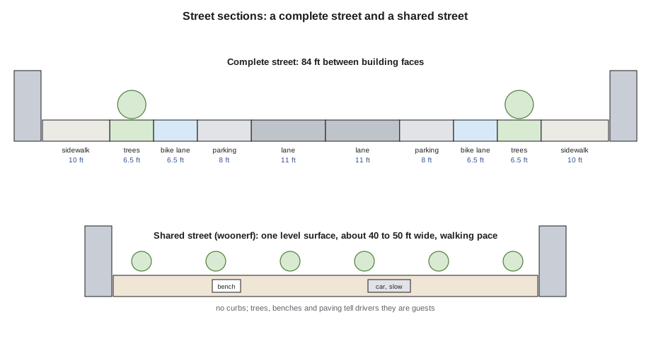
The ratio of street width to building height shapes how a street feels. A street whose width is roughly equal to the height of its buildings, a ratio of about 1:1, feels enclosed and comfortable, like an outdoor room. Ratios beyond about 1:3 or 1:4, as on a wide arterial lined with one-story shops, feel open and exposed. Trees can create enclosure where buildings are low.
Complete streets and Vision Zero
A complete street is designed for all users of all ages and abilities. The principle has been adopted by many cities and states since the 2000s. It does not mean that every street needs every element; it means that each street's design should consider everyone who uses or should be able to use it.
Vision Zero, adopted by the Swedish parliament in 1997 and since taken up by many cities, holds that no loss of life on the roads is acceptable and that the street system should be designed so that inevitable human mistakes do not kill people. Because the risk of death for a pedestrian hit by a car rises steeply with speed, Vision Zero design concentrates on speed: narrower lanes (about 10 to 11 ft instead of 12 ft), tighter corner radii, curb extensions that shorten crossings, raised crosswalks, protected bicycle lanes and lower posted limits on local streets. Minneapolis adopted a Vision Zero commitment in 2017 and lowered default speed limits on city streets to 25 and 20 mph in 2020.
Worked problem
Allocating a street section
The avenue is 84 ft between building faces and today has two travel lanes and a parking lane in each direction with narrow sidewalks. Redesign it as a complete street that keeps one travel lane each way and parking on both sides.
Show solution
- Start with the people on foot: 10 ft sidewalks on both sides, 20 ft total.
- Add a tree and furnishing zone of 6.5 ft on each side: 13 ft.
- Add one-way protected bicycle lanes of 6.5 ft each side: 13 ft.
- Parking lanes of 8 ft each side: 16 ft.
- That leaves 84 − 55 = 29 ft for two travel lanes of 11 ft (the bus will use them).
- Check the ratio: with four-story buildings of about 46 ft, width to height is about 1.8:1, comfortably enclosed once the trees mature.
Answer: The section in the figure: sidewalks, trees, bike lanes, parking and two 11 ft lanes. If the bus later needs a dedicated lane, the parking on one side can become a bus lane at peak times.
Shared streets and winter streets
Not every street needs separate zones. A shared street, called a woonerf in the Netherlands where the idea was developed in the 1970s, has a single level surface without curbs, shared by people walking, cycling and driving at walking pace. Trees, benches, planters and changes in paving signal to drivers that they are guests. Shared streets suit short, low-traffic streets with many people on foot, such as the lane between Greenway Homes and the hub, or the edges of a market. They need careful design for people with low vision, who rely on curbs to know where the roadway is; tactile paving and a clear, consistent path along the building edges help.
Winter changes everything. In a city where snow lies on the ground for four or five months and nights are long, the furnishing zone must hold plowed snow, sidewalks must be wide enough for machines to clear, crossings must stay walkable when windrows of snow are pushed to the corners, and street lighting matters more than in summer. Trees on the south side of an east-west street shade the sidewalk in summer but can leave it icy in winter; deciduous trees let the low winter sun through. Minneapolis's skyway system, which connects downtown buildings above the street, and its winter festivals show two different answers to the same climate: one brings life out onto the ice and snow; the other takes it above the street, at some cost to street life.
Back lanes and mid-block paths
Most prairie and Midwestern cities have back lanes (alleys) behind the houses, used for garages, garbage collection and utilities. Lanes give each block a second, quieter frontage. In many cities they are now being used for laneway houses or garden suites, which add homes without changing the street face. Mid-block paths through large blocks give pedestrians shortcuts and can become small public spaces. In the greenway district, the students propose reopening the two streets closed by the lumber yard, adding a new crossing of the greenway at each street that meets it, and opening a lane through the long blocks north of the avenue.
Exercise 3: streets and blocks
- For your district, measure the average block length and the intersection density.
- Pick five pairs of points and compare the walking distance along streets with the straight-line distance. Calculate route directness.
- Draw a section of the main street at 1/8 in = 1 ft, with all zones dimensioned. Redraw it as a complete street.
- Identify three places where a new connection (a street, path or crossing) would greatly shorten walks.
- Note how the street works in winter: where snow goes, which sidewalks are cleared and which crossings are blocked.
Common mistakes
MistakeMeasuring walking distance as the crow flies.
InsteadMeasure along the network and calculate route directness.
MistakeDesigning a street for peak-hour cars and fitting everyone else into what is left.
InsteadStart with sidewalks, trees and transit, then allocate the remainder.
MistakeMaking lanes as wide as possible for safety.
InsteadWider lanes raise speeds; narrower lanes and tight corners make streets safer for everyone.
MistakeRemoving curbs without thinking about people with low vision.
InsteadProvide tactile paving and a clear, consistent path in shared streets.
MistakeForgetting snow.
InsteadSize the furnishing zone for snow storage and keep crossings clear of windrows.
Summary and key terms
- Streets are the largest public space in a city and must serve many users, not just vehicles.
- Block size governs connectivity: small blocks give more intersections, shorter walks and more corners.
- Intersection density, block perimeter, route directness and walksheds measure connectivity.
- A street is designed in section as zones: frontage, through, furnishing, edge and roadway.
- Complete streets serve all users; Vision Zero designs for low speeds so mistakes are not fatal.
- Shared streets, back lanes, mid-block paths and winter design widen the urban designer's choices.
- Right of way
- The full width of public land between property lines, including sidewalks and roadway.
- Intersection density
- The number of street intersections per unit area, a measure of network connectivity.
- Route directness
- The ratio of network distance to straight-line distance between two points.
- Walkshed
- The area reachable on foot within a given distance or time along the street network.
- Complete street
- A street designed to serve people of all ages and abilities walking, cycling, using transit and driving.
- Woonerf
- A shared street with a single level surface where people on foot have priority and drivers travel at walking pace.
Practice problems
Work each problem on paper first, then reveal the answer to check.
Ingrid's walk is about 2,300 ft along the streets for a straight-line distance of 850 ft. What is the route directness?
Show answer
About 2.7, which is very poor; a ratio near 1.2 is good.
Why do narrower travel lanes tend to make streets safer?
Show answer
Drivers choose lower speeds when lanes are narrower, and lower speeds sharply reduce the risk of death in a collision.
What is the pedestrian through zone, and why must it be continuous?
Show answer
The clear path for walking; any obstruction forces people, especially wheelchair users, into the roadway or to turn back.
Name two ways to keep connectivity when a development needs a large block.
Show answer
Public mid-block paths and lanes, or courtyards open to the public.
What does a width-to-height ratio near 1:1 feel like?
Show answer
Enclosed and comfortable, like an outdoor room.
Lesson quiz · 5 questions
Score 60% or more to complete this lesson.
Create a free account to save your progress, take quizzes and earn a certificate.