
AERO-450 · Lesson 11 of 12 · 27 min
Drone regulations in the US (Part 107)
The Vertical Flight group cannot finish the wildfire aircraft's design without knowing how it will be allowed to fly. Rachel Oduya, who spent a decade with the FAA before joining Prairiewind Aerospace, runs a two-day workshop on US drone rules for the group, with Hélène and Sam, who will become the first company pilots for the drone. She starts with a warning that applies to every lesson she gives: rules change, the version in force on the day of the flight is the one that counts, and the regulator's own pages are the place to check it. The rules described here are those in force in late 2026.
How drone rules are built
Crewed aviation is regulated mainly by certifying things: the aircraft gets a type certificate, the pilot a license, the operator an operating certificate. Applying that model to every small drone would make them impossible to use, so regulators everywhere have adopted a risk-based approach. Low-risk operations, small drones flown within sight, away from people and below crewed traffic, are allowed under general operating rules with a simple pilot certificate and no aircraft certification. As the risk rises, through flight near or over people, in controlled airspace, beyond visual line of sight or with heavier aircraft, the rules require more: better pilot training, aircraft that meet design standards, operator organizations with procedures, and case-by-case approval. The two quantities that drive the risk are the harm a drone can do if it hits the ground, set by its size, speed and the people below, and the chance of meeting a crewed aircraft, set by the airspace and altitude.
The United States: 14 CFR Part 107
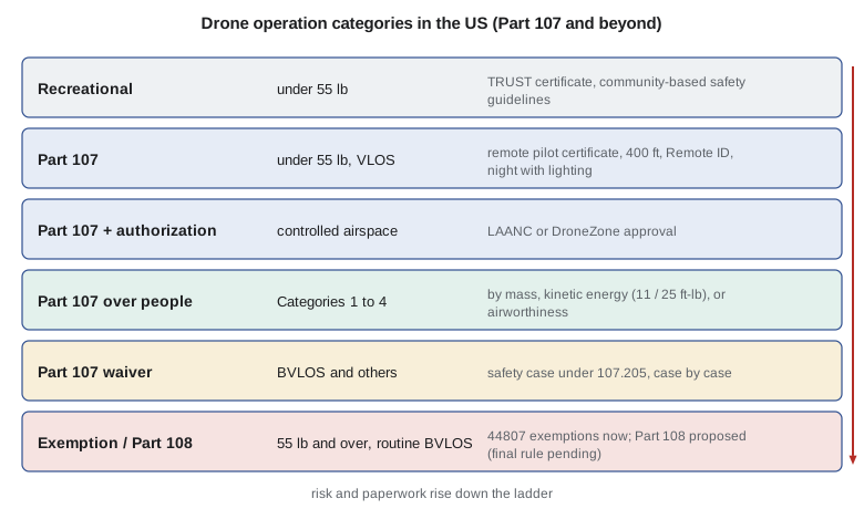
US rules for small unmanned aircraft systems in commercial use are in 14 CFR Part 107, in force since August 2016. A major amendment in 2021 added operations at night and over people and changed the recurrent training rules, and the Remote ID rule (14 CFR Part 89) took effect at the same time, with compliance required from September 2023 and enforced from March 2024. Part 107 applies to aircraft under 55 lb (25 kg) at take-off, including payload. Recreational flyers follow a separate statutory exception, which requires passing The Recommended UAS Safety Test (TRUST) and following community-based safety guidelines. Every drone flown under Part 107 must be registered with the FAA and marked with its registration number, whatever its weight.
The core operating limits
The core limits of Part 107 are simple. The aircraft must weigh less than 55 lb. The remote pilot in command, or a visual observer working with them, must keep it within visual line of sight with unaided vision. It must fly at or below 400 ft above ground level, or within 400 ft of a structure and no higher than 400 ft above its top. Groundspeed is limited to 100 mph (87 knots). Flight visibility must be at least 3 statute miles, and the drone must stay 500 ft below and 2000 ft horizontally from clouds. It must yield right of way to all crewed aircraft. One remote pilot may fly only one drone at a time. Operating from a moving vehicle is allowed only over sparsely populated areas, and never from a moving aircraft. Flight in Class B, C or D airspace, or in the surface area of Class E airspace designated for an airport, needs air traffic control authorization, usually obtained in seconds through the Low Altitude Authorization and Notification Capability (LAANC) or otherwise through the FAA DroneZone portal.
The remote pilot certificate requires passing an initial aeronautical knowledge test at an FAA-approved testing center, a minimum age of 16, and security vetting. Since the 2021 amendment, pilots keep their privileges by completing free online recurrent training every 24 calendar months. A pre-flight assessment of the operating area, a pre-flight check of the aircraft and a briefing of all crew members are required, and serious accidents must be reported to the FAA within 10 days: any serious injury or loss of consciousness, or damage of more than 500 dollars to property other than the drone.
Night, people and Remote ID
Since April 2021, Part 107 operations at night are allowed without a waiver if the pilot has completed the updated knowledge test or training and the drone has anti-collision lighting visible for at least 3 statute miles with a flash rate that makes it noticeable. The same lighting is required during civil twilight. Operations over people are allowed in four categories. Category 1 covers drones of 0.55 lb (250 g) or less with no exposed rotating parts. Category 2 drones must not cause injury above a severity equivalent to a transfer of 11 ft-lb of kinetic energy from a rigid object, must have no exposed rotating parts that could lacerate skin, and need a declaration of compliance accepted by the FAA. Category 3 raises the energy limit to 25 ft-lb but limits where the drone can fly over people, excluding open-air assemblies and allowing it only over people who are on a closed or restricted site and have been notified, or who are under cover. Category 4 requires an airworthiness certificate. Sustained flight over open-air assemblies also requires Remote ID.
Remote ID requires most registered drones to broadcast, from take-off to shutdown, their identity, position, altitude and velocity and the position of the control station, on unlicensed radio frequencies that ordinary smartphones can receive. A drone can comply by having Remote ID built in (standard Remote ID), by carrying a broadcast module, which also requires the pilot to keep it in sight, or by flying without Remote ID only within an FAA-recognized identification area. Remote ID does not make a drone visible to crewed aircraft's collision avoidance systems; its purpose is accountability, letting authorities and the public identify drones and their pilots.
Waivers, exemptions and Part 108
Operations outside Part 107's limits need a waiver under section 107.205, which the FAA grants case by case on the strength of a safety case showing that the operation can be conducted safely. Beyond-visual-line-of-sight operations, flights over people outside the four categories, and one pilot flying several drones are the most common subjects. Aircraft of 55 lb or more cannot use Part 107 at all; they need an exemption under 49 U.S.C. 44807 or another path, and agricultural spraying drones also need a Part 137 agricultural aircraft operator certificate. Drone delivery services have been certified as air carriers under Part 135. To make routine beyond-visual-line-of-sight operations possible without individual waivers, the FAA published a proposed rule, Part 108, in August 2025. It proposes a permit path for defined lower-risk operations and a certificate path for larger or more complex operators, aircraft up to 1320 lb built to consensus standards, right-of-way rules that depend on whether crewed aircraft are electronically visible, and a companion Part 146 for automated data service providers. The comment period closed in October 2025 and reopened briefly in early 2026 on right of way and electronic conspicuity. The final rule went to the White House for review in July 2026 and had not been published by late October 2026, so BVLOS still needs a waiver or exemption.
The SORA approach to risk
For operations that need case-by-case approval, the international reference is the Specific Operations Risk Assessment (SORA), developed by the Joint Authorities for Rulemaking on Unmanned Systems (JARUS), a group of national authorities, and updated as version 2.5 in 2024. SORA is widely used in Europe and has influenced risk assessment elsewhere. It works in a fixed sequence. The applicant describes the concept of operations. The intrinsic ground risk class (GRC) comes from the drone's size and speed and the population density below. Mitigations reduce it: strategic ones, such as sheltering or restricting the area, and effects-reducing ones, such as a parachute that lowers impact energy. The air risk class (ARC) comes from the airspace, altitude and the chance of meeting crewed aircraft, and it can be lowered by strategic measures. The final ground and air risk classes then give a specific assurance and integrity level (SAIL), from I to VI, which sets how robustly the operator must meet a list of operational safety objectives covering the aircraft, the crew, the procedures and the organization.
# SORA-lite: an illustrative ground and air risk screen in the style of the JARUS SORA method.
# The tables are simplified for teaching; a real assessment uses the current official tables and guidance.
import math
dims   = [1, 3, 8, 20, 40]                     # maximum characteristic dimension (m)
speeds = [25, 35, 75, 120, 200]                # matching maximum speed (m/s)
# rows: population density bands (people per km^2); columns: size/speed classes
grc_table = [("controlled ground area", 0,       [1, 1, 2, 3, 3]),
             ("under 5",                5,       [2, 3, 4, 5, 6]),
             ("under 50",               50,      [3, 4, 5, 6, 7]),
             ("under 500",              500,     [4, 5, 6, 7, 8]),
             ("under 5,000",            5000,    [5, 6, 7, 8, 9]),
             ("under 50,000",           50000,   [6, 7, 8, 9, 10])]
sail = {"a": [1, 2, 3, 4, 5, 6], "b": [2, 2, 3, 4, 5, 6], "c": [4, 4, 4, 4, 5, 6], "d": [6, 6, 6, 6, 6, 6]}
roman = ["I", "II", "III", "IV", "V", "VI"]
def intrinsic_grc(dim, vmax, density, controlled=False):
    col = next(i for i in range(5) if dim <= dims[i] and vmax <= speeds[i])
    if controlled: return grc_table[0][2][col]
    for name, limit, row in grc_table[1:]:
        if density < limit: return row[col]
    return None                                  # too dense for this screen
def sail_level(grc, arc):
    if grc > 7: return "outside the screen"
    return roman[sail[arc][max(grc, 2) - 2] - 1]
cases = [("Larkspur mapping over forest, far from towns", 2.7, 25, 3,   False, -1, "b"),
         ("Larkspur over farmland near a village",        2.7, 25, 40,  False, -1, "b"),
         ("Quadcopter inspecting a line near a suburb",   0.9, 18, 400, False, -2, "c"),
         ("Quadcopter inside a fenced substation",        0.9, 18, 0,   True,   0, "a")]
print("operation                                        iGRC  mitigations  final GRC  ARC  SAIL")
for name, dim, v, dens, ctl, mit, arc in cases:
    g = intrinsic_grc(dim, v, dens, ctl)
    gf = max(1, g + mit)
    print(f"  {name:46s}  {g:3d}      {mit:+d}          {gf:3d}       {arc}    {sail_level(gf, arc)}")
print()
# why size and speed matter: kinetic energy at impact
for name, m, v in (("250 g camera drone at 15 m/s", 0.25, 15), ("6 kg quadcopter at 15 m/s", 6, 15),
                   ("6 kg quadcopter falling from 120 m (drag-limited, about 30 m/s)", 6, 30),
                   ("11 kg Larkspur cruising at 22 m/s", 11, 22)):
print(f" {name:62s} kinetic energy {0.5*m*v*v:7.0f} J")operation iGRC mitigations final GRC ARC SAIL Larkspur mapping over forest, far from towns 3 -1 2 b II Larkspur over farmland near a village 4 -1 3 b II Quadcopter inspecting a line near a suburb 4 -2 2 c IV Quadcopter inside a fenced substation 1 +0 1 a I 250 g camera drone at 15 m/s kinetic energy 28 J 6 kg quadcopter at 15 m/s kinetic energy 675 J 6 kg quadcopter falling from 120 m (drag-limited, about 30 m/s) kinetic energy 2700 J 11 kg Larkspur cruising at 22 m/s kinetic energy 2662 J
The code uses simplified tables in the spirit of SORA; a real assessment uses the current official tables and guidance. The Larkspur mapping flight over forest far from towns, with a parachute as mitigation, reaches SAIL II, a level that a small, well-organized operator can meet. Over farmland near a village it moves up a ground risk class but stays at SAIL II. The quadcopter inspecting a line near a suburb is small, but the dense airspace near the suburb puts it in air risk class c, which drives it to SAIL IV, a demanding level. Inside a fenced substation, a controlled ground area with segregated airspace, it reaches SAIL I. The second block shows why size and speed matter so much: a 250 g camera drone at 15 m/s carries 28 J, while the 11 kg Larkspur at 22 m/s carries 2.7 kJ, a hundred times more.
# Which US rule path does each flight need? (simplified decision aid for 14 CFR Part 107 as of 2026)
FT_LB = 1.3558                                     # joules per foot-pound
def over_people_category(mass_kg, ke_J, exposed_props):
    ft_lb = ke_J / FT_LB
    if mass_kg <= 0.25 and not exposed_props: return "Category 1"
    if ft_lb <= 11 and not exposed_props: return "Category 2 (needs an FAA-accepted declaration of compliance)"
    if ft_lb <= 25 and not exposed_props: return "Category 3 (declaration, plus limits on sites and sustained flight)"
    return None                                     # only Category 4 (airworthiness certificate) or a waiver remains
def rule_path(mass_kg, vlos, over_people, controlled_airspace, night=False, ke_J=0.0):
    if mass_kg >= 24.95: return "55 lb or more: Part 107 does not apply; for spraying, a Part 137 certificate plus a 49 U.S.C. 44807 exemption"
    steps = ["remote pilot certificate", "registered drone with Remote ID"]
    if night: steps.append("anti-collision light visible 3 statute miles")
    if controlled_airspace: steps.append("LAANC or DroneZone airspace authorization")
    if not vlos: steps.append("BVLOS waiver under 107.205 (Part 108 not yet in force)")
    if over_people:
        cat = over_people_category(mass_kg, ke_J, exposed_props=True)
        steps.append(f"over people: no eligible category (kinetic energy {ke_J/FT_LB:.0f} ft-lb, limits 11 and 25 ft-lb) -> avoid or waiver"
                     if cat is None else cat)
    return "; ".join(steps)
flights = [("Quadcopter, 6 kg (13 lb), mapping a farm", 6, True, False, False, False, 675),
           ("Quadcopter, 6 kg, inspecting a line beside a sidewalk", 6, True, True, False, False, 675),
           ("Quadcopter, 6 kg, near Wichita Eisenhower airport at dusk", 6, True, False, True, True, 675),
           ("Larkspur, 11 kg (24 lb), wildfire mapping 25 km out", 11, False, False, False, False, 2662),
           ("Spray drone, 60 kg (132 lb), in sight over a field", 60, True, False, False, False, 0)]
for name, *args in flights:
print(f"{name}\n -> {rule_path(*args)}")Quadcopter, 6 kg (13 lb), mapping a farm
-> remote pilot certificate; registered drone with Remote ID
Quadcopter, 6 kg, inspecting a line beside a sidewalk
-> remote pilot certificate; registered drone with Remote ID; over people: no eligible category (kinetic energy 498 ft-lb, limits 11 and 25 ft-lb) -> avoid or waiver
Quadcopter, 6 kg, near Wichita Eisenhower airport at dusk
-> remote pilot certificate; registered drone with Remote ID; anti-collision light visible 3 statute miles; LAANC or DroneZone airspace authorization
Larkspur, 11 kg (24 lb), wildfire mapping 25 km out
-> remote pilot certificate; registered drone with Remote ID; BVLOS waiver under 107.205 (Part 108 not yet in force)
Spray drone, 60 kg (132 lb), in sight over a field
-> 55 lb or more: Part 107 does not apply; for spraying, a Part 137 certificate plus a 49 U.S.C. 44807 exemptionThe second program applies US rule paths to example flights. Mapping a farm in sight needs only a remote pilot certificate and a registered drone with Remote ID. Inspecting a line beside a sidewalk would put the 6 kg quadcopter over people, but at 498 ft-lb of kinetic energy it fits no category below Category 4, so the crew must keep people out of the area or obtain a waiver. Flying near Wichita Dwight D. Eisenhower National Airport at dusk adds anti-collision lighting and LAANC authorization. Larkspur's wildfire mapping, 25 km out, needs a BVLOS waiver while Part 108 is pending. A 60 kg spraying drone is outside Part 107 entirely. The aid is deliberately simple and leaves out many conditions; in practice Rachel checks every operation against the regulations themselves.
Wildfires, emergencies and privacy
Wildfire operations have special rules. The FAA issues temporary flight restrictions over wildfires under 14 CFR 91.137, and flying a drone inside one without the incident commander's authorization is illegal; the federal and state message to the public is simple: if you fly, we can't. Unauthorized drones near fires have repeatedly grounded firefighting aircraft. Larkspur will fly only as part of the state forest service's operation, under its aviation plan, with deconfliction from air tankers and helicopters by altitude, time and area. Drone operators must also respect state and local privacy laws, trespass and nuisance rules, and local restrictions on take-off and landing sites, which aviation rules do not override. Data from mapping and inspection flights may include images of people and property and must be handled accordingly.
Worked problem
Over-people category for a small drone
A 0.9 kg mapping drone flies at 12 m/s over a construction site with workers present. Estimate its kinetic energy in foot-pounds and identify which over-people categories might apply.
Show solution
- \(E = \tfrac{1}{2} \times 0.9 \times 12^{2} = 64.8\ \mathrm{J}\).
- \(64.8/1.356 = 47.8\ \mathrm{ft\,lb}\).
- Above 25 ft-lb, so Categories 2 and 3 do not apply; Category 1 needs 0.55 lb or less.
Answer: About 48 ft-lb, too much for Categories 1 to 3; the crew must keep workers out of the flight area, fly slower, use a lighter drone, or seek a waiver.
Worked problem
Choosing an airspace authorization path
Larkspur's operator wants to fly a mapping mission in Class D airspace near a regional airport. What does Part 107 require, and how does Part 108 change that if it is adopted as proposed?
Show solution
- Class D needs air traffic control authorization: LAANC if the location and altitude are within its facility maps, otherwise DroneZone.
- The mapping must stay in visual line of sight unless a BVLOS waiver is held.
- Part 108 as proposed would still require airspace access arrangements in controlled airspace, but would replace individual BVLOS waivers with permits or certificates.
Answer: LAANC or DroneZone authorization within visual line of sight under Part 107 today; the Part 108 details depend on the final rule.
Worked problem
Impact energy of Larkspur
Larkspur loses power at 22 m/s and its parachute opens, reducing its descent speed to 5 m/s. By what factor does the impact energy fall compared with striking the ground at its cruise speed?
Show solution
- Without parachute: \(\tfrac{1}{2} \times 11 \times 22^{2} = 2662\ \mathrm{J}\).
- With parachute: \(\tfrac{1}{2} \times 11 \times 5^{2} = 138\ \mathrm{J}\).
- Ratio: \(2662/138 = 19\).
Answer: About 19 times less energy, which is why a parachute counts as a ground risk mitigation.
Common mistakes
MistakeA drone under 250 g needs no registration under Part 107.
InsteadDrones flown under Part 107 must be registered whatever their weight; the 0.55 lb threshold applies to recreational flyers.
MistakePart 107 allows flight at 400 ft above any terrain or structure.
InsteadThe limit is 400 ft above ground, or within 400 ft of a structure and no higher than 400 ft above its top.
MistakePart 108 is now in force for BVLOS.
InsteadAs of late October 2026 the final rule had not been published; BVLOS still needs a waiver or exemption.
MistakeAviation rules override local privacy and land-use rules.
InsteadThey govern flight safety; privacy, trespass and land-use rules still apply.
Summary and key terms
- US commercial drone operations under 55 lb follow 14 CFR Part 107: visual line of sight, 400 ft, 100 mph, right of way to crewed aircraft, and ATC authorization through LAANC or DroneZone in controlled airspace.
- Pilots need a remote pilot certificate and recurrent training every 24 months.
- Night flight needs anti-collision lighting; flight over people uses four categories based on mass, kinetic energy and airworthiness.
- Remote ID broadcast is required for most drones.
- Operations beyond these limits need waivers; heavier aircraft need exemptions.
- Part 108, proposed in 2025 for routine BVLOS, was still awaiting publication in late 2026.
- SORA-style risk assessment combines ground risk, air risk and mitigations into an assurance level.
- Wildfire TFRs, privacy and local rules also apply.
- sUAS
- Small unmanned aircraft system: an aircraft under 55 lb with its control station and links.
- Remote pilot in command
- The person with final authority and responsibility for a Part 107 flight.
- LAANC
- Low Altitude Authorization and Notification Capability for near-real-time airspace authorization.
- Remote ID
- Broadcast of drone identity and position under 14 CFR Part 89.
- Category 2 and 3
- Over-people categories limited to 11 and 25 ft-lb injury-equivalent kinetic energy.
- Waiver
- FAA approval to deviate from specified Part 107 rules with a safety case.
- 44807 exemption
- Statutory authority for the FAA to allow operations of aircraft not covered by Part 107.
- Part 108
- Proposed FAA rule for routine beyond-visual-line-of-sight operations.
- SAIL
- Specific assurance and integrity level, the output of a SORA assessment.
Practice problems
Work each problem on paper first, then reveal the answer to check.
What is the maximum altitude under Part 107?
Show answer
400 ft above ground level, or 400 ft above a structure within a 400 ft radius of it.
How often must a remote pilot complete recurrent training?
Show answer
Every 24 calendar months.
What kinetic energy limit applies to Category 3 over people?
Show answer
25 ft-lb injury-equivalent transfer, with site restrictions.
In the SORA screen, why did the suburb inspection reach SAIL IV?
Show answer
Its air risk class c, from dense low-altitude airspace near a suburb, drives the assurance level up.
Why do aviation authorities restrict drones near wildfires?
Show answer
Unauthorized drones force firefighting aircraft to stop operations.
Lesson quiz · 5 questions
Score 60% or more to complete this lesson.
Create a free account to save your progress, take quizzes and earn a certificate.