
GEOM-499 · Lesson 5 of 12 · 22 min
Field data collection
The first epoch begins on the Monday after the canal is drained. For the next ten days the Coulee Watch team is on site early each morning, and the quality of everything that follows depends on what happens there. Field data cannot be repaired later. A wrong antenna height, a target bumped before the flight or a missing scan overlap can be detected in the office, but by then the moment has passed and the ground may have moved. This lesson covers how the team works safely, how it records what it does, how it checks data before leaving the site, and what it learns when things go wrong.
Safety first: the job hazard assessment
Grant Okonkwo gives the team its field safety orientation the week before. The site combines three different environments, each with its own hazards. On the crest there are new houses under construction, trucks, open excavations and homeowners. On the slope the ground is steep, up to about 35 degrees in places, loose and slippery when wet, and the coulees are home to rattlesnakes in the warm months. At the foot is the canal: even when drained, its liner is steep and slick, the bottom holds soft silt and pools of water, and in spring it can fill quickly.
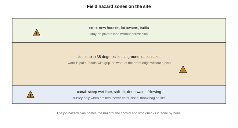
Each morning the crew completes a written hazard assessment for the day's tasks, the field-level version of the job hazard analysis taught in the safety courses. It names each task, the hazards, the controls and who will check them. The team's rules are simple and non-negotiable: nobody works alone on the slope or in the canal; boots with good grip and high-visibility vests are worn at all times; nobody works within 2 m of the crest edge without a plan approved by the mentor; a throw bag and a first aid kit are on site whenever anyone is in the canal; and the team checks in with Leah at noon and when it leaves. Under Alberta's occupational health and safety legislation, the university and the host firm share duties for students doing field work, and both require these controls.
The drone adds its own hazards. Sofia briefs the crew before every flight: the take-off and landing zone is marked with cones, a visual observer watches for aircraft and people, and the flight is paused if anyone walks under the drone's path. Batteries are carried in fireproof bags. On the third day a resident walks along the crest walkway with a dog during a flight; the observer calls a pause, Sofia holds the drone in place, and the flight resumes when the walkway is clear. The event is noted in the flight log, as the rules expect.
Setting the marks and targets
Jonas and Liam set the six control marks on the first day, driving each rod to refusal below frost depth and cementing the cap. Each mark gets a photo from two directions, a sketch with ties to nearby features, and a description that someone else could use to find it in five years. Marks that cannot be found again are worthless to a monitoring program, so the descriptions are written on site, not from memory.
The twelve slope targets go in on the second day. Placing them takes longer than planned because two locations chosen from the old lidar turn out to be on loose slumped material that will not hold a pin. Liam moves them a few metres to firmer ground and records the change and the reason. The control targets for the drone are laid out on the morning of each flight and surveyed by RTK twice, an hour apart, with each observation logged. The checkpoint targets are placed and surveyed by a different pair of students from those who lay out the control targets, which makes it less likely that one person's mistake affects both.
Static GNSS sessions and the field log
Static sessions run on days three and four for session A and days five and six for session B. Every set-up is recorded on a field log sheet: mark name, session, receiver and antenna serial numbers, start and end time, antenna height measured twice to the reference point, and any problems such as nearby trucks or a gust that moved the tripod. Modern receivers log much of this automatically, but the antenna height and the notes about conditions still come from people, and they cause most of the blunders.
Before leaving the site each evening, Jonas downloads the receiver files and runs a quick check on the log. The script below shows the check for session A. It flags sessions that are too short, that had poor satellite geometry or too few satellites, or where the two antenna height readings disagree by more than 2 mm.
# Coulee Watch: screen the epoch 1 static GNSS session log before leaving the site
log = [  # mark, session, minutes, PDOP max, satellites min, antenna heights read (m)
    ("CW1", "A", 242, 1.6, 14, (1.5021, 1.5019)),
    ("CW2", "A", 238, 1.7, 13, (1.4876, 1.4879)),
    ("CW3", "A", 245, 2.9, 9, (1.5512, 1.5514)),
    ("CW4", "A", 251, 1.5, 15, (1.4433, 1.4932)),
    ("CW5", "A", 119, 1.8, 12, (1.5108, 1.5106)),
    ("CW6", "A", 240, 1.6, 14, (1.4720, 1.4722)),
]
need_min, pdop_max, sats_min, hi_tol = 180, 3.0, 10, 0.002
for mark, ses, mins, pdop, sats, (h1, h2) in log:
    issues = []
    if mins < need_min: issues.append(f"short session ({mins} min)")
    if pdop > pdop_max: issues.append(f"PDOP {pdop}")
    if sats < sats_min: issues.append(f"only {sats} satellites")
    if abs(h1 - h2) > hi_tol: issues.append(f"antenna heights differ by {abs(h1 - h2) * 1000:.1f} mm")
    print(f"{mark} {ses}: " + ("ok" if not issues else "; ".join(issues)))
# slant height to vertical height for an antenna measured to the edge of the ground plane
r_edge, slant = 0.0815, 1.5200
print(f"slant {slant:.4f} m -> vertical {(slant ** 2 - r_edge ** 2) ** 0.5:.4f} m")CW1 A: ok CW2 A: ok CW3 A: only 9 satellites CW4 A: antenna heights differ by 49.9 mm CW5 A: short session (119 min) CW6 A: ok slant 1.5200 m -> vertical 1.5178 m
Three of the six sessions are flagged. CW3, at the foot of the slope, had only nine satellites at times, because the slope blocks a large part of the eastern sky; the session is long enough to be usable but will be watched in processing. CW5's session was cut to just under two hours when a battery failed, so it is short of the three hours planned. And at CW4 the two antenna height readings differ by almost 50 mm, far more than measurement noise. A difference that close to 5 cm usually means one reading was taken to the wrong reference point or written down with a digit swapped.
The crew goes back to CW4 the next morning. The tripod is still standing for session B, and the height to the antenna reference point reads 1.4932 m, matching the second reading. The first reading of 1.4433 was a transposition. Jonas corrects the log with a dated note rather than overwriting the original value, so that anyone reviewing the data can see what changed and why. CW5 gets an extra session on the reserve day. Catching these problems on site cost an hour; finding them in December would have cost a return trip in the snow.
Worked problem
Slant height to vertical height
Some antennas are measured with a slant tape from the mark to the edge of the ground plane. The ground plane radius is 0.0815 m and the slant reading is 1.5200 m. What is the vertical height to the edge?
Show solution
- \[h = \sqrt{s^2 - r^2} = \sqrt{1.5200^2 - 0.0815^2}\]
- \[h = \sqrt{2.310400 - 0.006642} = 1.5178 \text{ m}\]
Answer: The vertical height is 1.5178 m. The 2.2 mm difference from the slant reading would become a 2.2 mm height error if the conversion were forgotten; the offset from the edge to the antenna reference point is then added from the antenna calibration.
Drone flights
The weather allows flying on day four. Sofia lays out the take-off zone on the crest walkway, completes the pre-flight checklist, confirms the airspace authorization and briefs the crew. The nadir pass goes smoothly. The oblique pass is interrupted after five of eight lines when the wind rises above the drone's limit; the rest is flown on day seven. The loss of most of day four's second pass is the reason the week 12 earned value in lesson 1 shows the drone task incomplete.
After each flight, Sofia checks the images on a laptop before packing up: the count matches the plan, no image is blurred, the exposure is consistent, and the camera recorded a position for every image. A quick low-resolution alignment in the processing software confirms that the overlap is sufficient and that no gaps exist over the slope. If a gap had appeared, the drone could have re-flown that line the same day. The images and flight logs are copied to two drives, one of which goes home with a different team member.
Scanning and total station sets
The terrestrial scans take a full day. Ines sets up the scanner at each of the four stations along the canal road, places the six spherical targets so that each scan sees at least four of them, and records each set-up on the scan log. She checks the registration of each new scan to the previous one in the field software before moving on; a registration error of more than 10 mm would mean a target was bumped.
The slope targets are measured on the last two days. Jonas and Nadia set up the total station on CW2 and then CW4, measure two complete sets to each visible target and to two reference marks, and check that the rounds agree before moving on. On the slope, prisms are held on the target pins with a short pole and a bipod; Nadia notes that two targets on the upper row are partly hidden by shrubs and need a longer pole. Small field decisions like this are recorded so that the second epoch is measured in the same way.
Metadata, naming and data management
By the end of the epoch the team has about 1,300 drone images, four scans, twelve static GNSS files plus repeats, levelling records, two total station files and dozens of photos and sketches. Without a system this would be chaos by January. The team agreed its file naming rules in the charter: every file name begins with the epoch, then the method, then the location and the date, for example E1_GNSS_CW4_B_2026-10-09. Every evening the day's data are copied to the project drive and to an off-site backup, and a checksum list is generated so that later copies can be verified.
The field logs, sketches and photos are scanned and filed with the data they describe. Each log has a section for changes and anomalies. The team's mentor reminds them that in a dispute or an audit, the field notes are the primary record: the processed numbers are only as credible as the notes that support them.
| Item | Epoch 1 plan | Epoch 1 actual | Note |
|---|---|---|---|
| Control marks set | 6 | 6 | All described with photos and ties |
| Static sessions | 12 | 13 | Extra session at CW5 after battery failure |
| Drone passes | 2 | 2 | Oblique pass completed on reserve day |
| Control targets / checkpoints | 14 / 32 | 14 / 32 | One checkpoint under tall grass, kept and flagged |
| Scan stations | 4 | 4 | Registration within 6 mm |
| Slope targets | 12 | 12 | Two moved off slumped ground before measuring |
The second epoch
The second epoch, in April, repeats the first as exactly as possible: the same marks, the same flight plan and height above ground, the same scanner stations and target positions, the same total station set-ups. Repeating the procedure is what makes the two epochs comparable. Two differences are unavoidable and are recorded: the spring ground is wetter and the grass is flattened by snow, which changes the vegetation effect on the terrain model; and one checkpoint has been destroyed by a maintenance vehicle and is replaced by a new one, which is surveyed but not used in the comparison of the two epochs.
Common mistakes
MistakeWriting mark descriptions from memory after leaving the site.
InsteadDescribe, photograph and sketch each mark on site so it can be found again years later.
MistakeOverwriting a wrong value in the field log.
InsteadStrike it through, add the correction with date and reason, and keep both.
MistakeDiscovering a short session or a bad antenna height in the office.
InsteadScreen the logs before leaving the site so problems can be fixed while the crew is there.
MistakeChanging the procedure in the second epoch to save time.
InsteadRepeat the first epoch's procedure as closely as possible so the epochs are comparable.
Summary and key terms
- A daily written hazard assessment and simple non-negotiable rules keep the crew safe on the crest, slope and canal.
- Marks and targets need on-site descriptions, photos and ties so they can be found and trusted later.
- Field logs record set-ups and anomalies; most GNSS blunders come from antenna heights recorded by people.
- Screening data before leaving the site catches problems while they can still be fixed.
- Consistent file naming, daily backups and checksums protect the data.
- The second epoch repeats the first as closely as possible, and any differences are recorded.
- Hazard assessment
- A written review of each task's hazards, controls and responsibilities before work starts.
- Field log
- The primary written record of set-ups, observations and conditions during a survey.
- Antenna reference point
- The physical point on a GNSS antenna to which heights and calibrations refer.
- Visual observer
- A crew member who watches the airspace and ground around a drone flight.
- Checksum
- A short code computed from a file's contents, used to verify that a copy is identical.
- Repeatability
- Carrying out a survey in the same way each time so that results can be compared.
Practice problems
Work each problem on paper first, then reveal the answer to check.
Name the three hazard zones on the site.
Show answer
The crest, the slope and the canal.
Two antenna height readings differ by 49.9 mm. What is the likely cause?
Show answer
A transposed digit or a reading to the wrong reference point; it must be resolved before processing.
Why are checkpoints surveyed by a different pair from the control targets?
Show answer
To reduce the chance that one person's error affects both control and test.
Why must the second epoch use the same flight height above ground?
Show answer
So that ground sample distance and accuracy match and the epochs can be compared.
A slant height is 1.4800 m and the ground plane radius is 0.0815 m. What is the vertical height to the edge?
Show answer
√(1.4800² − 0.0815²) = 1.4778 m.
What should be done with a value found to be wrong in the field log?
Show answer
Keep the original, add the correction with the date and reason.
Lesson quiz · 5 questions
Score 60% or more to complete this lesson.
Create a free account to save your progress, take quizzes and earn a certificate.