
GEOM-499 · Lesson 10 of 12 · 19 min
Professional and legal considerations
A capstone is a student project, but the data it produces can affect real people. The city might change building permit conditions because of it; the canal operator might spend a large budget; a homeowner might worry about their house; a cultural site might be exposed. The professional and legal side of the project is therefore not an appendix. It shapes what the team may do, what it may say, what it may publish and who is responsible. This lesson works through the questions Coulee Watch had to answer: who may do and sign what, what the team owes the clients and the public, how liability is limited, who owns and may use the data, how privacy is protected, and how Indigenous and cultural interests are respected.
Who may do and sign what
Surveying and engineering are regulated professions. In Alberta, defining property boundaries is reserved to Alberta land surveyors registered with the Alberta Land Surveyors' Association, which in 2026 moved under the province's Professional Governance Act. Engineering work, including professional opinions on slope stability or the design of repairs, is reserved to professional engineers registered with APEGA. Students may do this kind of work only under the direct supervision of a licensed professional who takes responsibility for it.
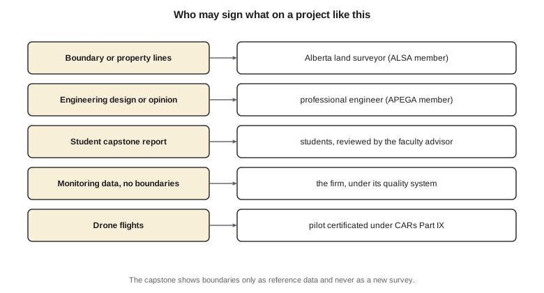
Coulee Watch was scoped to stay clear of reserved work. It does not establish boundaries: property lines from the registered plans are shown on the maps as reference data, clearly labelled as not surveyed by the team. It does not give geotechnical opinions: the findings describe measured change and recommend assessment by a geotechnical engineer. The monitoring measurements themselves, control coordinates, terrain models and target positions, are technical data that the team may produce and report as a student project, reviewed by the advisor and the mentor. Ruth Albrecht reviews the report to confirm that nothing in it could be mistaken for a boundary survey.
There is one grey area. The canal cross-sections compare the bank with the design line from the as-built drawings, and the bank is the edge of the district's right of way. The team is careful to describe the comparison as a comparison with the design section, not with the right-of-way boundary, and Ruth confirms that wording. Small choices of language like this keep a technical report from making legal statements it is not entitled to make.
Duties to the clients and the public
Codes of ethics for engineers and land surveyors in both countries put the public first: practitioners must hold paramount the safety, health and welfare of the public, act within their competence, be honest and objective, and avoid conflicts of interest. Students are not yet bound by these codes as members, but the capstone is where they practise them, and the program assesses ethics as part of the outcomes.
Coulee Watch meets a real ethical test in March. Preliminary processing of the second epoch shows the movement at T7 and T8. The final report is weeks away, and the team wonders whether it should wait. Leah's advice is clear: if there is any chance the movement affects public safety, the clients must be told promptly, with the uncertainty stated, rather than at the scheduled presentation. The team sends a short memo to Claire and Marta the next day: preliminary results show about 2 cm of movement at two targets above the canal; the results are being checked; no movement has been detected near the houses; the team recommends that a geotechnical engineer look at the slope above the canal soon. Marta arranges an inspection, and the canal is refilled in that reach only after the inspection is done.
The memo was carefully worded. It did not alarm the homeowners with a claim the data did not support, and it did not delay information that might matter for safety. Being prompt and being accurate are both duties; the skill is in doing both at once.
Liability and the limits of the work
Even student work can be relied on, so the team and the university limit how it may be used. The report includes a clear statement of purpose and limitations: it was produced as a university capstone project; it measures surface change and movement at stated accuracies; it is not a geotechnical assessment, a boundary survey or a design; and those questions belong to the appropriate licensed professionals. The statement does not weaken the report's accuracy statements, which the team stands behind. It defines the scope, so that nobody uses the data for something they were not designed to do.
The university's agreement with the clients, signed at the start, also sets out ownership of the data, confidentiality, insurance and the fact that the clients receive the work as is from a student project. Coulee Geomatics, as the firm lending equipment and mentoring, has its own professional liability insurance and confirms with its insurer that mentoring students on a university project is within its coverage.
Who owns the data and how it may be used
The project uses data from many owners under different licences, and it creates new data that someone must own. The data register from lesson 3 records the licence of every input. Federal open data come under the Open Government Licence - Canada and many Alberta datasets under the Open Government Licence - Alberta; both allow reuse with attribution. The radar archive data come with the providers' own terms, which allow research use with attribution.
The new data created by the team are owned as set out in the agreement: the university and the students keep the right to use them for teaching and publication, and the clients receive a licence to use, modify and share them for their own purposes. The final handover in lesson 11 includes a short licence file with each dataset so that a future user, years from now, knows what they may do with it.
Privacy
A drone flying along the crest of a new subdivision photographs back yards, windows and people. Even though the flight is lawful and the images are needed for the project, publishing them would intrude on privacy. Alberta's Protection of Privacy Act, which replaced the province's earlier access and privacy law in June 2025 for public bodies such as the city and the university, and the federal private-sector privacy law, PIPEDA, both treat images of identifiable people as personal information. The team's rule is simple: collect only what is needed, keep the full imagery inside the project, and publish only what has been reviewed.
In practice that means masking the orthomosaic in the public layer wherever it looks into private lots. The script below generalizes sensitive locations and computes how much of the public orthomosaic must be masked to keep a 20 m buffer behind the rear lot lines of the first phase.
# Coulee Watch: generalize sensitive locations before the public release
import math
# features recorded on the slope by the heritage monitor and the team (local grid, m)
sensitive = [(312.4, 140.2), (318.9, 133.7), (655.0, 96.5)]
# public dataset: snap each sensitive point to the middle of a 250 m cell and count per cell
cell = 250.0
cells = {}
for x, y in sensitive:
    key = (math.floor(x / cell), math.floor(y / cell))
    cells[key] = cells.get(key, 0) + 1
for (i, j), k in sorted(cells.items()):
    cx, cy = (i + 0.5) * cell, (j + 0.5) * cell
    shown = "present" if k else "none"
    print(f"cell {i},{j} at {cx:.0f}, {cy:.0f}: {shown} (exact count withheld)")
# privacy: drop orthomosaic tiles that see into private back yards along the crest
lots = [(80 + 15 * k, 300.0) for k in range(20)]       # rear lot corners of the first phase
buffer = 20.0
tiles = [(x, y) for x in range(0, 1500, 25) for y in range(0, 450, 25)]
def near(t):
    cx, cy = t[0] + 12.5, t[1] + 12.5
    return any(math.hypot(cx - a, cy - b) < buffer + 17.7 for a, b in lots)
masked = [t for t in tiles if near(t)]
print(f"{len(masked)} of {len(tiles)} 25 m tiles masked in the public layer ({len(masked) / len(tiles):.1%})")cell 1,0 at 375, 125: present (exact count withheld) cell 2,0 at 625, 125: present (exact count withheld) 44 of 1080 25 m tiles masked in the public layer (4.1%)
About 4 percent of the 25 m tiles are masked, a small cost for a large reduction in intrusion. Any people visible in the images elsewhere are blurred. The client layer, behind a sign-in, contains the full imagery for the city's and the district's engineering staff only.
Indigenous and cultural interests
Coulees in southern Alberta are part of landscapes with deep Indigenous history, and many contain archaeological and cultural sites. The district's cultural resource monitor has recorded features on part of the slope and asked that their locations not be published. The team treats this as a firm requirement. The exact locations stay in the client layer only, and the public layer shows only that sensitive features are present within generalized 250 m cells, without counts. Field crews were briefed not to disturb any feature and to stop and report if they found anything that might be cultural.
Beyond individual sites, there is a broader principle. Data about Indigenous lands, resources and peoples should be governed in ways that respect Indigenous rights and interests. In Canada, the First Nations principles of ownership, control, access and possession, known by the trademarked acronym OCAP and stewarded by the First Nations Information Governance Centre, set out how First Nations data should be collected, protected, used and shared. Coulee Watch does not collect data about any First Nation or tribe, but its site lies within a broader landscape where those principles apply, and the team's report recommends that any future monitoring program that could affect cultural sites involve the Nations concerned from the start, not only through the canal operator's monitor.
Alberta's Historical Resources Act protects archaeological and historic resources, and development that may affect them can require assessment and approval from the province. These rules did not require a permit for the team's non-intrusive survey, but they explain why the confidentiality request matters.
Codes of ethics in practice
Professional codes are short, but applying them takes judgment. During the project the team meets three smaller ethical questions besides the March memo. A builder on the crest asks Sofia, informally, whether the drone images could show if a neighbour has encroached on his lot; she politely declines, because that is a boundary question and the images are not a boundary survey. A classmate asks to use the Coulee Watch data for another course project; the team checks the agreement, which allows teaching use, and asks the classmate to cite the data and keep the sensitive layers out of any public work. And when the team realizes that its first schedule promised more than it could deliver, it tells the clients in the week 12 review rather than letting them find out later. None of these questions is dramatic. Together they show what acting with integrity, within competence and in the public interest looks like on an ordinary project.
The program assesses these behaviours through the reflective essay that each student writes at the end of the capstone, describing an ethical or professional question they met and how it was handled. Writing it down helps students recognize such questions when they meet them again in practice, often without anyone labelling them as ethics.
Common mistakes
MistakeShowing registered boundaries on the maps as if the team had surveyed them.
InsteadLabel them as reference data; establishing boundaries is reserved to licensed land surveyors.
MistakeWaiting for the final report to mention a possible safety issue.
InsteadTell the clients promptly, accurately and with stated uncertainty.
MistakePublishing the full orthomosaic because the flight was lawful.
InsteadLawful collection does not make publication appropriate; mask private yards and blur people.
MistakePublishing exact cultural site locations because they are in the data.
InsteadRespect confidentiality requests; generalize locations in public products.
Summary and key terms
- Boundary surveys and engineering opinions are reserved to licensed professionals; the capstone was scoped to avoid them.
- Careful wording keeps technical reports from making legal or geotechnical statements they cannot support.
- Codes of ethics put the public first; possible safety issues are reported promptly and accurately.
- A scope and limitations statement says what the data may be relied on for.
- Every input's licence is recorded; new data come with a licence file for future users.
- Privacy and cultural confidentiality shape what is published; public layers are generalized and masked.
- Reserved practice
- Work that the law allows only licensed professionals to carry out.
- Professional of record
- The licensed professional who takes responsibility for work and signs it.
- Scope and limitations statement
- A statement of what a report covers and what it may not be relied on for.
- Data licence
- The terms under which a dataset may be used, modified and shared.
- Generalization
- Reducing the precision of locations in published data to protect sensitive information.
- Indigenous data governance
- Principles and practices that give Indigenous peoples authority over data about them.
Practice problems
Work each problem on paper first, then reveal the answer to check.
Why does the Coulee Watch report label property lines as reference data?
Show answer
The team did not survey them, and establishing boundaries is reserved to licensed land surveyors.
What did the team do when preliminary results showed movement in March?
Show answer
Sent a prompt, carefully worded memo to the clients recommending a geotechnical inspection.
What does the scope and limitations statement say the report is not?
Show answer
Not a geotechnical assessment, boundary survey or design.
How are sensitive cultural locations shown in the public layer?
Show answer
Only as presence in generalized 250 m cells, without exact locations or counts.
About what share of the public orthomosaic tiles are masked for privacy?
Show answer
About 4 percent.
Why does the comparison with the canal design line avoid calling it the right-of-way boundary?
Show answer
Calling it a boundary would be a legal statement the team is not entitled to make.
Lesson quiz · 5 questions
Score 60% or more to complete this lesson.
Create a free account to save your progress, take quizzes and earn a certificate.