
GEOM-499 · Lesson 4 of 12 · 21 min
Survey and data acquisition plan
A data acquisition plan turns the methods statement into instructions for specific days: which marks will be set where, how long each GNSS session lasts, where the drone flies and at what height, where the targets and checkpoints go, where the scanner stands, which permissions are needed, and what happens if something goes wrong. A good plan lets a crew that was not at the planning meeting do the work correctly. It also lets a reviewer check, before anyone goes to the site, that the data will be able to meet the requirements. This lesson builds the Coulee Watch plan in that order: control, airspace and permissions, the flight, ground targets, scanning and slope targets, and contingencies.
Designing the control network
Everything the team measures hangs from the control network, so it is designed first. Jonas proposes six new marks, CW1 to CW6, plus CR1, the continuously operating reference station that Coulee Geomatics set up beside the subdivision in the earlier geodesy course. Three marks sit on the crest above the slope, well back from the edge and outside the private lots, and three sit on the flat ground beside the canal at the foot. None is on the slope itself, because a control mark that moves would make every measurement on the slope look stable.
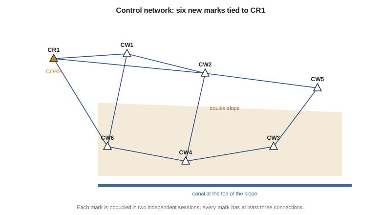
The marks are steel rods driven below frost depth with a domed cap, the same design the mentor firm uses for long-term monitoring. Each mark is occupied in two independent static GNSS sessions of at least three hours on different days, with a different antenna height each time, so that a centring or height error in one session shows up as a disagreement. The baselines are processed both from CR1 and from a second continuously operating station some distance away, to check that CR1 itself has not shifted. The network geometry gives every mark at least three connections, which provides redundancy for the adjustment in lesson 6.
GNSS alone gives heights to about a centimetre. Requirement R1 asks for 2.5 cm vertically, which GNSS can meet, but the canal engineers want better heights on the three foot marks, because they will use them to check the canal grade. Jonas adds a digital levelling loop from CR1 through four of the marks. Levelling over a few kilometres reaches about a millimetre, and it will also test the GNSS heights.
Pre-analysis
Before any field work the team estimates whether the plan can meet the requirements. For the levelling, the standard deviation of a height difference grows with the square root of the distance, about 1 mm per root kilometre for the equipment and procedure chosen. The longest leg is about 1.1 km, so its standard deviation is about 1.05 mm, and heights at the far marks should be known to a few tenths of a millimetre after adjustment. For the GNSS sessions, three hours on short baselines with modern receivers typically gives a few millimetres horizontally and somewhat more vertically. Both comfortably meet R1, with margin for a bad session. Pre-analysis turns 'we think it will be fine' into a number the reviewer can check.
Airspace, pilot certification and permissions
Flying a drone is regulated aviation. In Canada, drones from 250 g to 25 kg are flown under Part IX of the Canadian Aviation Regulations. The pilot needs a certificate for the kind of operation; flights in controlled airspace or near people need an advanced certificate, and flights in controlled airspace also need an authorization from NAV CANADA. Rules changed on 1 April and 4 November 2025, adding new operation types and allowing some flights beyond visual line of sight under new conditions. The Coulee Watch flights are routine visual line of sight flights below 122 m, but the site lies within the approach area of the city airport, so Sofia, who holds an advanced certificate, applies for an airspace authorization a week ahead.
The team also needs permission to be on the land. The crest marks are on city road allowance and a walkway; the slope is municipal reserve and district right of way; the canal belongs to the district. Written permissions from the city and the district are attached to the plan. The team does not need, and does not seek, access to private lots: the flight plan keeps the drone over public land and the right of way, and the imagery of back yards is masked before any public release, as lesson 10 explains. Residents along the crest receive a one-page letter from the city explaining what the drone is doing and when.
The flight plan
The flight plan starts from the ground sample distance. Requirement R2 asks for 3 cm or less; Sofia plans 2.5 cm to leave margin and to help the terrain model reach 3.6 cm. With the same survey drone used in the photogrammetry course, which has an 8.8 mm lens and a 2.41 micrometre pixel, the flying height above ground follows from the ratio of focal length to pixel size.
Steep slopes need more overlap than flat ground, because the terrain rises toward the camera on one side of each image and drops away on the other, changing the scale and hiding some ground. Sofia chooses 80 percent forward and 70 percent side overlap, and flies the block twice: once with the camera pointing straight down and once tilted about 30 degrees toward the slope, which improves the reconstruction of steep faces. She also plans the flight lines parallel to the slope contours so that the height above ground stays roughly constant along each line.
# Coulee Watch: drone flight plan for the slope and canal reach
import math
f_mm, pix_um, w_px, h_px = 8.8, 2.41, 5472, 3648     # camera from the GEOM-310 drone
gsd = 0.025                                           # target ground sample distance, m
H = gsd * f_mm / (pix_um / 1000)                      # flying height above ground, m
across = w_px * gsd; along = h_px * gsd               # long side across track
fwd, side = 0.80, 0.70                                # overlaps for steep terrain
base = along * (1 - fwd); spacing = across * (1 - side)
L, W = 1400.0, 260.0                                  # block covering slope and canal
lines = math.ceil(W / spacing) + 1
photos = lines * (math.ceil(L / base) + 1)
speed = 8.0                                           # m/s
minutes = lines * (L + 60) / speed / 60               # 60 m run-in per line
print(f"flying height above ground   {H:6.1f} m")
print(f"footprint                    {across:.0f} m x {along:.0f} m")
print(f"photo base / line spacing    {base:.1f} m / {spacing:.1f} m")
print(f"flight lines {lines}, photos {photos}, about {minutes:.0f} min in the air")
print(f"time between photos          {base / speed:.1f} s")
# ASPRS Edition 2 asks for at least 30 checkpoints; scale up with area
area = 31.0 * 1.0                                    # block area in ha
gcp = 14; cps = 32                                    # control targets and independent checkpoints
print(f"block {area:.0f} ha: {gcp} control targets, {cps} checkpoints "
f"(Edition 2 minimum is 30), {area / (gcp + cps):.2f} ha per target")flying height above ground 91.3 m footprint 137 m x 91 m photo base / line spacing 18.2 m / 41.0 m flight lines 8, photos 624, about 24 min in the air time between photos 2.3 s block 31 ha: 14 control targets, 32 checkpoints (Edition 2 minimum is 30), 0.67 ha per target
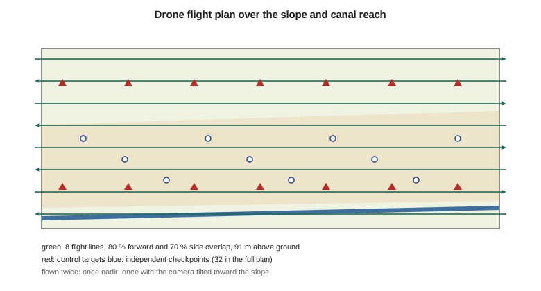
Eight lines, about 624 photos and some 24 minutes in the air per pass mean two passes need four or five batteries with changes, plus setup. At 8 m/s the camera fires every 2.3 seconds, comfortably within the drone's capability. Each epoch therefore needs about half a day of flying if the weather cooperates, and the plan books two reserve days.
Worked problem
Height above ground on a slope
The drone flies at a constant 91.3 m above the take-off point on the crest. The canal at the slope foot is 42 m lower. What ground sample distance does the camera get at the canal, and what should the pilot do?
Show solution
- \[H_\text{canal} = 91.3 + 42 = 133.3 \text{ m}\]
- \[\mathrm{GSD} = 133.3 \times \frac{0.00241}{8.8} = 0.0365 \text{ m}\]
Answer: About 3.7 cm, which fails the 3 cm requirement. The pilot should use terrain following or fly lines at different altitudes so that the height above ground stays near 91 m.
Ground control targets and checkpoints
Ground control targets fix the photogrammetric block to the project frame; checkpoints test it. They must never be mixed: a checkpoint used as control is no longer an independent test. Sofia plans 14 control targets around the edges and through the middle of the block, at the crest, part way down the slope on two benches and along the canal. She plans 32 checkpoints spread across the open ground, more than the minimum of 30 that ASPRS Edition 2 asks for, so that a few lost or disturbed targets will not leave the test short. Checkpoints in vegetation are surveyed and reported separately, because the standard treats vegetated vertical accuracy differently.
Each target is a painted 60 cm square with a centre mark, pinned to the ground. Its position is measured by network RTK from the new control marks, twice, with the two observations at least an hour apart so that the satellite geometry changes. Edition 2 asks for checkpoints at least twice as accurate as the product. With the terrain model aiming at about 3.6 cm vertically, the checkpoints should be good to about 1.8 cm or better; two independent RTK observations from nearby marks are expected to give about 1.2 cm.
Terrestrial scanning and slope targets
Ines and Liam plan the scanner set-ups along the canal maintenance road at the foot of the slope, four stations about 75 m apart covering the 300 m of eroding toe. Each scan overlaps its neighbours, and six spherical targets on tripods tie the scans together and to the control marks. The scanner is set to a point spacing of about 1 cm at 50 m. Registration error between scans is expected to be a few millimetres, and the georeferencing to the control network to about 5 mm.
The twelve slope targets, T1 to T12, are steel pins about 1 m long driven into the slope in three rows, with a threaded top for a prism. They are placed where the radar data and the old lidar suggest movement and at a few points where none is expected, so that the analysis can compare moving and stable ground. Each target is measured in each epoch by two complete sets of angles and distances from two different control marks, giving redundancy and a check on centring.
Contingencies and the field plan
The plan ends with what happens when things go wrong. If wind exceeds the drone's limit, the team scans and runs the levelling instead and flies on a reserve day. If CR1 fails, sessions are processed from the second continuously operating station. If a control target is disturbed between placement and flight, it becomes a checkpoint candidate only if it can be re-surveyed after the flight; otherwise it is discarded. If the canal is refilled early, the canal reach has already been surveyed first. Each day's field plan names the crew, the tasks, the equipment list, the safety plan from lesson 5 and the check-in time with the mentor.
Checking the plan before the field
Before the plan is approved, Leah walks the site with the team for an afternoon. The walk changes three details. One crest mark is moved 6 m so that it will not be buried by a driveway the builder is about to pour. The take-off zone is moved off the walkway to a gravel pad so that pedestrians are not routed under the drone. And two checkpoint locations on the lower bench are moved out of a shallow drainage channel that would be wet in April. None of these could be seen on the orthophoto; all would have cost time in the field. A site visit before field work is cheap insurance.
Common mistakes
MistakePlacing control marks on the slope being monitored.
InsteadPut control on stable ground off the slope; a moving control mark hides movement.
MistakeFlying a constant altitude over 40 m of relief.
InsteadKeep height above ground nearly constant, or the ground sample distance and accuracy change across the slope.
MistakeUsing some checkpoints as control when control is short.
InsteadKeep control and checkpoints separate; a used checkpoint is no longer an independent test.
MistakeForgetting airspace authorization because the flight is short.
InsteadCheck airspace for every site; near an airport an authorization is needed regardless of flight length.
Summary and key terms
- The acquisition plan turns methods into specific, checkable instructions for each field day.
- Control marks go on stable ground, with independent sessions and redundant connections; levelling strengthens heights.
- Pre-analysis estimates achievable accuracy before field work and shows whether requirements can be met.
- Drone flights need a certificated pilot, airspace checks and authorizations, and land access permissions.
- Flying height follows from ground sample distance; steep slopes need more overlap, oblique passes and constant height above ground.
- Control targets and checkpoints are kept separate; checkpoints must number at least 30 and be twice as accurate as the product.
- Pre-analysis
- Estimating the precision a survey design will achieve before carrying it out.
- Independent session
- A repeat GNSS occupation on a different day with a new set-up and antenna height.
- Ground sample distance
- The ground size of one image pixel.
- Oblique pass
- A drone flight with the camera tilted, used to capture steep faces.
- Ground control target
- A surveyed target used to fix a photogrammetric block to the reference frame.
- Airspace authorization
- Permission from the air navigation authority to fly a drone in controlled airspace.
Practice problems
Work each problem on paper first, then reveal the answer to check.
Why is no control mark placed on the slope?
Show answer
If the slope moves, a mark on it moves too and makes the slope appear stable.
What flying height gives a 2 cm GSD with an 8.8 mm lens and 2.41 µm pixels?
Show answer
0.02 × 8.8 / 0.00241 = 73.0 m.
Why are checkpoints in vegetation reported separately?
Show answer
ASPRS Edition 2 reports vegetated vertical accuracy but does not use it as a pass or fail test.
What is the purpose of the oblique drone pass?
Show answer
To capture the steep faces of the slope better than nadir images alone.
Why are slope targets measured from two different control marks?
Show answer
For redundancy and to check centring and set-up errors.
What happens if CR1 fails during the epoch?
Show answer
Sessions are processed from the second continuously operating station.
Lesson quiz · 5 questions
Score 60% or more to complete this lesson.
Create a free account to save your progress, take quizzes and earn a certificate.