
GEOM-430 · Lesson 4 of 12 · 21 min
Space geodetic techniques: VLBI, SLR, DORIS
GNSS is the space geodetic technique every surveyor uses, and GEOM-300 covered it in depth. Three other techniques are less familiar but just as essential to the global frame: very long baseline interferometry, satellite laser ranging and DORIS. Each has a unique strength, and without them GNSS positions would drift in ways that no amount of GNSS data could detect. This lesson explains how each works, what it measures and why the frame needs all of them.
Very long baseline interferometry
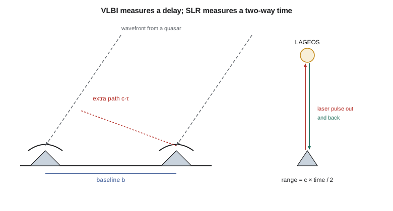
VLBI uses radio telescopes thousands of kilometres apart to observe the same quasar at the same time. Each telescope records the faint radio noise from the source, together with precise time tags from a hydrogen maser clock. Later, the recordings are brought together in a correlator, which finds the time offset at which the two noise streams match best. That offset is the delay: the difference in the arrival time of the same wavefront at the two telescopes.
Here b is the baseline vector between the telescopes, s is the unit vector towards the source and c is the speed of light. As the Earth turns, the direction of s relative to the baseline changes, so the delay changes through the day. A session of 24 hours observing many sources in many directions determines the baseline vector to a few millimetres, and the orientation of the Earth in space with it.
The code computes the delay for an illustrative 2,800 km baseline and a source at declination 30° at three hour angles. The delay changes from about −0.5 ms to −8.6 ms over the eight hours. Since one picosecond of delay is 0.3 mm of path, measuring the delay to about 10 ps gives millimetre-level geometry, provided the many error sources are modelled: the troposphere and ionosphere above each telescope, the clock drift of each maser, the deformation of the telescope structure with gravity and temperature, and the tides that move both ends of the baseline.
VLBI is unique in three ways. It alone ties the terrestrial frame to the celestial frame directly, since it observes quasars. It alone measures UT1 over the long term. And, with SLR, it provides the scale of the frame. Its network is small, a few dozen telescopes, and the older ones were large, slow dishes built for astronomy. A new generation of smaller, fast-slewing antennas, known as VGOS (the VLBI Global Observing System), observes a wide band of frequencies and is being installed around the world to reach millimetre accuracy. In North America, NASA operates VGOS antennas at observatories in the eastern United States, and Canadian radio astronomers and geodesists were among the pioneers of VLBI in the 1960s, with early experiments between observatories in Ontario and British Columbia.
Satellite laser ranging
In SLR, a ground station fires a short laser pulse at a satellite carrying corner-cube retroreflectors, which send the light straight back. The station measures the round-trip time with a precision of a few picoseconds. Half that time multiplied by the speed of light, after corrections for the atmosphere and the satellite's reflector geometry, is the range.
The workhorses for geodesy are the LAGEOS satellites, launched in 1976 and 1992: dense brass-and-aluminium spheres 60 cm across, covered with retroreflectors, in orbits about 5,900 km high. They carry no electronics and need no power; they will stay in orbit for millions of years. Being heavy and compact, they feel little drag or solar radiation pressure, so their orbits respond almost purely to the Earth's gravity field. That makes them ideal for determining the Earth's centre of mass, which is the centre of their orbits, and the low-degree terms of the gravity field.
import math
c = 299792458.0
# 1. VLBI: geometric delay for a baseline b and a source direction s, tau = -b.s / c
b = (2103000.0, -1612000.0, 905000.0)   # baseline vector, m (illustrative)
L = math.sqrt(sum(v * v for v in b))
def unit(dec, ha):
    d, h = math.radians(dec), math.radians(ha)
    return (math.cos(d) * math.cos(h), -math.cos(d) * math.sin(h), math.sin(d))
print(f"baseline length {L / 1000:.3f} km")
for ha in (-60, 0, 60):
    s = unit(30.0, ha)
    tau = -sum(bi * si for bi, si in zip(b, s)) / c
    print(f"source dec 30, hour angle {ha:+3d}: delay {tau * 1e3:+.6f} ms")
print(f"1 ps of delay corresponds to {c * 1e-12 * 1000:.2f} mm of path")
# 2. SLR: two-way time of flight to LAGEOS-1 and the range
h_lageos = 5860e3
for elev in (90, 30, 20):
    R = 6378e3; e = math.radians(elev)
    rho = -R * math.sin(e) + math.sqrt((R * math.sin(e)) ** 2 + h_lageos ** 2 + 2 * R * h_lageos)
    print(f"elevation {elev:2d} deg: range {rho / 1000:8.1f} km, two-way time {2 * rho / c * 1000:.3f} ms")
print(f"timing to 5 ps gives a one-way range precision of {c * 5e-12 / 2 * 1000:.2f} mm")
# 3. DORIS: Doppler shift of the 2.036 GHz beacon for a range rate of 6 km/s
f0 = 2.036e9; rr = -6000.0
print(f"Doppler shift {-f0 * rr / c / 1000:.2f} kHz")baseline length 2800.032 km source dec 30, hour angle -60: delay -0.514108 ms source dec 30, hour angle +0: delay -7.584418 ms source dec 30, hour angle +60: delay -8.579688 ms 1 ps of delay corresponds to 0.30 mm of path elevation 90 deg: range 5860.0 km, two-way time 39.094 ms elevation 30 deg: range 7731.6 km, two-way time 51.580 ms elevation 20 deg: range 8488.6 km, two-way time 56.630 ms timing to 5 ps gives a one-way range precision of 0.75 mm Doppler shift 40.75 kHz
The two-way time to LAGEOS is about 39 ms at the zenith and about 57 ms at 20° elevation. Timing to 5 ps gives a one-way range precision of 0.75 mm, though the real accuracy is limited by the atmosphere, the reflector array and the station's biases to a few millimetres. SLR stations range to many other satellites as well, including GNSS satellites that carry reflector arrays, which allows the GNSS orbits to be checked independently, and altimetry satellites, whose orbits must be known to a centimetre for sea level work.
The SLR network is small and unevenly spread, with relatively few stations in the southern hemisphere, and that limits the stability of the frame's origin. Ranging is also weather-dependent: the laser needs a clear sky. The International Laser Ranging Service coordinates the stations and the analysis. In the United States, NASA operates several stations and is installing a new generation of automated systems; Canada relies largely on the international network for laser ranging.
A few stations also range to retroreflectors left on the Moon by the Apollo astronauts and Soviet landers. Lunar laser ranging, with round-trip times of about 2.5 seconds, has measured the Moon's distance to centimetres for decades. It shows that the Moon recedes from the Earth by about 3.8 cm per year as tidal friction transfers angular momentum from the Earth's rotation to the Moon's orbit, the same process that slowly lengthens the day. It also provides some of the most precise tests of general relativity. For the terrestrial frame, its contribution is small, but it is a reminder that geodesy and fundamental physics share the same instruments.
DORIS
DORIS, developed by the French space agency, reverses the usual geometry. About 60 ground beacons spread evenly around the world, many on islands and in remote places, transmit on two frequencies, about 2 GHz and 400 MHz. Receivers on satellites measure the Doppler shift of the signals as they pass overhead. The Doppler shift gives the rate of change of range between beacon and satellite, from which the satellite's orbit and the beacons' positions are estimated. The two frequencies allow the ionospheric effect to be removed, as with dual-frequency GNSS.
For a range rate of 6 km per second, the shift on the 2.036 GHz signal is about 41 kHz, as the code shows. DORIS was designed for precise orbits of altimetry satellites, and it still flies on most of them. Its even global network, independent of the other techniques, makes it a valuable contributor to the ITRF and to the monitoring of the Earth's centre of mass and of polar motion.
How the techniques complement each other
| Technique | Measures | Unique strengths | Weaknesses |
|---|---|---|---|
| VLBI | Delay between telescopes | Celestial link, UT1, scale | Few stations, sessions not continuous |
| SLR | Two-way laser range | Centre of mass (origin), scale, low-degree gravity | Weather, uneven network |
| GNSS | Code and phase ranges | Dense network, continuous, cheap | Correlated with orbits; antenna phase centres |
| DORIS | Doppler from ground beacons | Even global network, altimetry orbits | Lower precision per station |
GNSS on its own cannot define the scale of the frame well, because the phase centre offsets of the satellite antennas and the scale are strongly correlated; it cannot define the origin well, because the orbits are affected by solar radiation pressure in ways that mimic an origin shift; and it cannot give UT1 over long periods. The other techniques supply those elements, and GNSS then spreads the frame to thousands of stations and millions of users. Co-location, as lesson 2 showed, is what joins them, and the most valuable sites, sometimes called core or fundamental sites, have all four.
A newer idea is co-location in space: a single satellite carrying a GNSS receiver, an SLR reflector, a DORIS receiver and a VLBI transmitter, so that all four techniques observe the same object with precisely known connections. The European Space Agency's Genesis mission, planned for the later 2020s, is designed to do this, with the aim of improving the frame's accuracy towards the 1 mm goal.
How the observations are organized
Each technique has an international service under the International Association of Geodesy: the International VLBI Service for Geodesy and Astrometry (IVS), the International Laser Ranging Service (ILRS), the International DORIS Service (IDS) and the International GNSS Service (IGS). The services schedule observations, collect data, run analysis centres that compute solutions independently, and combine those solutions into official products. That structure, with several independent analyses of the same data, is how errors in software or models are caught. When analysis centres disagree, the reasons are investigated before the combination is released.
VLBI observes in sessions. Twice a week, networks of eight to a dozen telescopes observe for 24 hours to produce station positions and full Earth orientation parameters. Every day, short sessions of about an hour on one or two long east-west baselines, called Intensives, measure UT1 quickly, because GNSS cannot. SLR stations track satellites whenever the sky is clear, following priorities set by the ILRS. DORIS and GNSS run continuously. The products are delivered weekly or daily, and the IERS combines them into the Earth orientation series and, every few years, into a new ITRF.
Errors common to all techniques
All the techniques see the Earth through its atmosphere and from sites that move with the tides. The solid Earth tide raises and lowers the ground by up to about 30 cm twice a day; ocean tides load the crust and move coastal stations by centimetres; the atmosphere's weight changes with the weather and moves stations by millimetres. Conventional models for these effects, published by the IERS, are applied identically by all the analysis centres so that the techniques agree. A station position in the ITRF is a conventional position, with the periodic tidal motions removed according to those conventions. A surveyor who uses a precise point positioning service benefits from the same models without seeing them.
Worked problem
An SLR range at 30° elevation
A pulse to LAGEOS returns after 51.58 ms. What is the range, before atmospheric correction?
Show solution
- \[\rho = \frac{299\,792\,458 \times 0.05158}{2} = 7\,731.6\ \text{km}\]
Answer: About 7,732 km, matching the geometric range computed in the code for 30° elevation.
Coulee Geomatics and the techniques
None of Coulee Geomatics' work uses VLBI, SLR or DORIS directly. But when Leah explains to the district why CR1's coordinates are trustworthy to a few millimetres, the chain runs from the pillar through the GNSS antenna to the IGS orbits, to the ITRF, and so to radio telescopes, laser stations and beacons on islands in the Pacific. Ruth asks her to put one sentence about that chain in every station report. A client who knows that a coordinate depends on an international system is more likely to treat its metadata with respect.
Common mistakes
MistakeThinking GNSS alone can define a global frame.
InsteadGNSS needs VLBI and SLR for scale, origin and Earth rotation.
MistakeConfusing VLBI's delay with a range.
InsteadThe delay is a time difference between two telescopes, not a distance to the source.
MistakeAssuming SLR works in any weather.
InsteadIt needs a clear line of sight for the laser.
MistakeForgetting that tides move every station.
InsteadApply conventional tide models; ITRF positions are conventional tide-free or as defined by the conventions.
Summary and key terms
- VLBI measures delays between radio telescopes observing quasars; it links the celestial and terrestrial frames and gives UT1.
- SLR measures two-way laser ranges to satellites such as LAGEOS; it defines the frame's origin.
- DORIS measures Doppler shifts from about 60 ground beacons on satellites.
- GNSS gives density and continuity; the other techniques give origin, scale and orientation.
- Co-located sites, and in future co-location in space, join the techniques.
- All techniques apply the same conventional models for tides and loading.
- VLBI
- Very long baseline interferometry, using widely separated radio telescopes observing the same source.
- VGOS
- The VLBI Global Observing System, a network of fast, broadband antennas.
- SLR
- Satellite laser ranging, measuring two-way laser travel times to satellites with retroreflectors.
- LAGEOS
- Passive geodetic satellites covered with retroreflectors, in orbits about 5,900 km high.
- DORIS
- A Doppler system using ground beacons and satellite receivers.
- Correlator
- A processor that finds the time offset between recordings from two telescopes.
Practice problems
Work each problem on paper first, then reveal the answer to check.
What does a VLBI correlator determine?
Show answer
The time offset at which the recordings from two telescopes match: the delay.
How long does a laser pulse take to reach LAGEOS at the zenith and return?
Show answer
About 39 ms.
Why are LAGEOS orbits good for determining the centre of mass?
Show answer
They are dense and compact, so they respond almost purely to gravity.
Which technique transmits from the ground and receives on the satellite?
Show answer
DORIS.
Why does GNSS alone not give a reliable scale?
Show answer
Satellite antenna phase centre offsets are correlated with scale.
Lesson quiz · 5 questions
Score 60% or more to complete this lesson.
Create a free account to save your progress, take quizzes and earn a certificate.