
GEOM-430 · Lesson 1 of 12 · 20 min
Terrestrial and celestial reference systems
Every coordinate a surveyor writes down is a statement about a reference system: an agreed origin, an agreed orientation, an agreed scale and an agreed way of handling time. In GEOM-230 the reference system could be treated as a single fixed thing, an ellipsoid attached to the Earth. That picture is good enough for a plane survey or a property boundary, but it hides most of what modern geodesy is about. The Earth spins, wobbles, flexes under the tides and the weight of its oceans and ice, and its plates drift across its surface. Positions measured to a millimetre only make sense if we say exactly which frame they belong to and at which moment.
This course follows Coulee Geomatics through a year of work that touches every part of that problem. The irrigation district has asked the firm to turn pillar CR1 near Lethbridge into a continuously operating GNSS reference station, to submit it to the Canadian Geodetic Survey's network of stations, and to brief district staff on how the national frames and heights are changing. At the same time, a university research group has asked to use the firm's long monitoring record at the diversion dam for a study of how the reservoir's load bends the crust. Leah Tran, now the firm's geodesy specialist, leads the work, with Theo Martel on computations, Ruth Albrecht reviewing, and Grant Okonkwo and Ines Dahl in the field.
Systems and frames
Geodesists separate two ideas that everyday language runs together. A reference system is the set of definitions: where the origin is, how the axes are oriented, what the unit of length is, how they evolve with time, and which physical models and constants go with them. A reference frame is a realization of that system: a set of physical points, each with published coordinates and, these days, velocities, from which anyone can reach the system by measurement. The International Terrestrial Reference System (ITRS) is a system; ITRF2020 is one of its frames. The difference matters because frames are revised as data and methods improve, while the system they realize stays the same.
Two families of reference system are needed. A terrestrial system rotates with the Earth, so that a point on stable ground keeps nearly fixed coordinates. A celestial system does not rotate with the Earth; it is tied to directions in space, so that the positions of distant objects stay nearly fixed in it. Satellites move according to the laws of mechanics, which are simplest in a frame that is not rotating, so orbits are computed in a celestial frame and then turned into terrestrial coordinates. Radio telescopes observe quasars whose directions are fixed in the celestial frame, and their measurements are interpreted in both at once.
The celestial reference system
The International Celestial Reference System (ICRS) has its origin at the barycentre of the solar system and axes fixed by the directions of several thousand extremely distant radio sources, mostly quasars. They are so far away that their apparent motions are tiny, so they provide a far better fixed background than the stars, which all move measurably. The frame that realizes the ICRS, the International Celestial Reference Frame (ICRF), is a catalogue of positions of these sources measured by very long baseline interferometry. Its current version, ICRF3, was adopted in 2018 and includes positions at several radio frequencies. Optical positions from the Gaia mission are aligned to it, so the celestial frame used by astronomers and geodesists is the same.
For Earth-based work, a version of the celestial system is placed at the centre of the Earth: the Geocentric Celestial Reference System (GCRS). It has the same orientation as the ICRS but moves with the Earth around the Sun, and it includes the effects of relativity. Satellite orbits, including those of GNSS satellites, are integrated in the GCRS.
The terrestrial reference system
The ITRS has its origin at the centre of mass of the whole Earth, including the oceans and atmosphere. Its unit of length is the SI metre, consistent with the relativistic time scale used for the Earth. Its orientation was originally set to agree with an older international convention for the pole and the origin of longitudes, and its orientation is required to have no net rotation with respect to the Earth's crust as a whole. That last condition is subtle: the plates all move, so a frame cannot be fixed to every one of them. Instead, the frame is defined so that the sum of all horizontal motions over the surface has no overall rotation.
Coordinates in a terrestrial frame are usually given as Earth-centred, Earth-fixed X, Y and Z, which can be turned into latitude, longitude and ellipsoidal height on a chosen ellipsoid such as GRS80, as in GEOM-230. The ellipsoid is a computational convenience; the frame itself is defined by the coordinates and velocities of real stations.
Connecting the two: the Earth's orientation
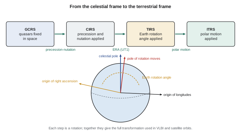
To turn a vector from the celestial frame into the terrestrial frame, three rotations are applied in turn. The first accounts for precession and nutation: the slow circling of the Earth's axis in space over about 26,000 years, caused by the pull of the Sun and Moon on the equatorial bulge, and the smaller nodding motions with periods from days to 18.6 years. The second is the rotation of the Earth about its axis, measured by the Earth rotation angle. The third is polar motion: the axis of rotation wanders relative to the crust by several metres, in a combination of an annual cycle and a free wobble of about 14 months, called the Chandler wobble.
Here Q is the precession and nutation matrix, R is a rotation about the pole by the Earth rotation angle, and W contains the polar motion. The modern convention, adopted by the International Astronomical Union in 2000 and 2006, uses intermediate frames whose pole is the Celestial Intermediate Pole and whose origins of longitude are chosen so that the Earth rotation angle is a simple linear function of UT1. The older approach, using the equinox and Greenwich sidereal time, gives the same final answer but mixes precession into the rotation angle. Both still appear in software and textbooks.
where T_u is the number of days of UT1 since 12:00 on 1 January 2000. The second term shows that the Earth turns once relative to the distant quasars in a little less than a solar day: the factor 1.0027 is the ratio of the solar day to the sidereal day.
Earth orientation parameters
Precession and nutation can be predicted well from theory, though the observations reveal small corrections. Earth rotation and polar motion cannot be predicted precisely: they depend on the exchange of angular momentum between the solid Earth, the atmosphere, the oceans and the core. So they are measured, continuously, and published as Earth orientation parameters (EOPs) by the International Earth Rotation and Reference Systems Service (IERS). The parameters are the two coordinates of the pole, x_p and y_p; the difference UT1 minus UTC, which tracks the irregular rotation; the length of day; and the small celestial pole offsets that correct the nutation model.
The length of day varies by about a millisecond over the year, mostly because winds change with the seasons: when the atmosphere spins faster to the east, the solid Earth slows to conserve angular momentum. Over decades it varies with motions in the core, and over centuries tidal friction lengthens the day. Leap seconds were introduced to keep UTC within 0.9 s of UT1; the international timekeeping community has decided to stop adding them by 2035, so UT1 and UTC will gradually separate and the published UT1 minus UTC will matter even more.
| Parameter | Typical size | Main source |
|---|---|---|
| Polar motion x_p, y_p | a few tenths of an arcsecond (several metres at the surface) | GNSS, VLBI, SLR |
| UT1 minus UTC | up to 0.9 s while leap seconds remain | VLBI only, for the long-term value |
| Length of day excess | about 1 ms, varying through the year | VLBI, GNSS (short term) |
| Celestial pole offsets | a fraction of a milliarcsecond | VLBI |
Only VLBI observes the Earth's rotation against the quasars directly, so it alone provides UT1 in the long run. Satellite techniques measure polar motion very well and the rate of rotation over short periods, but their orbits drift with respect to space in ways that cannot be separated from a slow error in UT1. This is one reason why the global reference frame needs all the space geodetic techniques together, as lesson 4 explains.
Computing the rotation
The code computes the Earth rotation angle for a moment in November 2026 and uses it, in simplified form, to find where a well-known quasar is overhead in terrestrial longitude and its hour angle at CR1. It also estimates how far precession has turned the equinox since 2000 and how large a typical polar motion offset is at the surface.
import math
# Earth rotation angle (ERA) and a simple precession estimate for an epoch.
def julian_date(y, mo, d, h=0.0):
    if mo <= 2: y -= 1; mo += 12
    a = y // 100; b = 2 - a + a // 4
    return int(365.25 * (y + 4716)) + int(30.6001 * (mo + 1)) + d + b - 1524.5 + h / 24.0
jd = julian_date(2026, 11, 2, 6.0)          # 2026-11-02 06:00 UT1
du = jd - 2451545.0                          # days since J2000.0
era = 2 * math.pi * ((0.7790572732640 + 1.00273781191135448 * du) % 1.0)
print(f"Julian date              {jd:.4f}")
print(f"days since J2000.0       {du:.4f}")
print(f"Earth rotation angle     {math.degrees(era):.4f} deg")
# A radio source (quasar) at right ascension 12h 29m 06.7s, declination +02 03 08.6 (3C 273, rounded)
ra = math.radians(15 * (12 + 29 / 60 + 6.7 / 3600)); dec = math.radians(2 + 3 / 60 + 8.6 / 3600)
# Simplified: treat the celestial intermediate frame as fixed, so the source's terrestrial longitude is ra - era
lon_east = (math.degrees(ra - era) + 180) % 360 - 180
print(f"source over longitude    {lon_east:.3f} deg (east positive)")
site_lon = -112.827087889
ha = (site_lon - lon_east + 180) % 360 - 180
print(f"hour angle at the site   {ha:.3f} deg")
# Precession of the equinox: about 50.29 arcseconds per year
years = du / 365.25
print(f"years since J2000.0      {years:.3f}")
print(f"accumulated precession   {50.29 * years / 3600:.4f} deg = {50.29 * years:.0f} arcsec")
# Polar motion: a pole offset of 0.2 arcsec moves the axis this far on the surface
print(f"pole offset 0.2 arcsec {6378137 * math.radians(0.2 / 3600):.2f} m on the surface")Julian date 2461346.7500 days since J2000.0 9801.7500 Earth rotation angle 131.1859 deg source over longitude 56.092 deg (east positive) hour angle at the site -168.919 deg years since J2000.0 26.836 accumulated precession 0.3749 deg = 1350 arcsec pole offset 0.2 arcsec 6.18 m on the surface
The Earth rotation angle at 06:00 UT1 on 2 November 2026 is about 131.19°. Treating the intermediate frame as fixed, the quasar is overhead at about 56° east longitude at that moment, so at CR1 its hour angle is about −169°: it is far below the horizon, almost on the opposite side of the Earth, and Leah would not try to observe it then. Precession has turned the equinox by about 1,350 arcseconds, more than a third of a degree, since 2000. A polar motion of 0.2 arcseconds, typical of the pole's offset, corresponds to about 6 m at the surface. That is large enough that neglecting polar motion in satellite orbit work would be a gross error, even though it hardly matters for a single traverse.
Worked problem
Sidereal and solar days
How much shorter is the Earth's rotation period relative to the quasars than the 86,400 s solar day?
Show solution
- \[T = \frac{86\,400}{1.00273781191} = 86\,164.1\ \text{s}\]
- \[86\,400 - 86\,164.1 = 235.9\ \text{s} \approx 3\ \text{min}\ 56\ \text{s}\]
Answer: The Earth turns once relative to the quasars about 3 minutes 56 seconds faster than a solar day.
Why surveyors need this
It is fair to ask why a surveyor staking a canal needs any of this. The answer is that GNSS has made every survey a space geodetic survey. The satellites' orbits come from the celestial frame; the broadcast and precise ephemerides are turned into terrestrial coordinates using the Earth orientation parameters; and the receiver's position comes out in whatever terrestrial frame the orbits were expressed in. When Leah processes a day of data from CR1 with precise orbits, the software silently uses EOPs from the IERS. When a mistake in a frame or an epoch shows up as a few centimetres of unexplained offset, she needs to know which link in the chain to check.
There is a professional reason too. As national frames become time-dependent, as lessons 9 and 10 describe, clients will ask why a point's coordinates change when nothing on the ground has moved. The honest answer involves the difference between a frame that rotates with the plate and one that does not, and the surveyor is the person expected to give it.
Common mistakes
MistakeTreating ITRF2020 and the ITRS as the same thing.
InsteadThe ITRS is the system; ITRF2020 is one realization of it, and later frames will differ slightly.
MistakeIgnoring polar motion because it is only a fraction of an arcsecond.
InsteadAt the Earth's surface it amounts to metres, which matters for orbits and global frames.
MistakeUsing UTC where UT1 is needed for Earth rotation.
InsteadApply the published UT1 minus UTC; the two will drift further apart once leap seconds stop.
MistakeAssuming the length of day is constant.
InsteadIt varies by about a millisecond with the seasons and over longer periods with the core and tides.
Summary and key terms
- A reference system is a set of definitions; a reference frame realizes it with real points.
- The celestial system is fixed by quasars; the terrestrial system rotates with the Earth.
- Precession and nutation, Earth rotation and polar motion link the two.
- The Earth rotation angle is a linear function of UT1 in the modern convention.
- Earth orientation parameters are measured continuously and published by the IERS.
- Every GNSS survey depends on these links through the orbits.
- ICRS
- The International Celestial Reference System, fixed by the directions of distant radio sources.
- ITRS
- The International Terrestrial Reference System, with its origin at the Earth's centre of mass and rotating with the Earth.
- Earth rotation angle
- The angle of the Earth's rotation measured from the celestial intermediate origin, linear in UT1.
- Polar motion
- The motion of the rotation pole relative to the crust.
- Chandler wobble
- A free wobble of the Earth's axis with a period of about 14 months.
- UT1
- The time scale that follows the Earth's actual rotation.
- EOP
- Earth orientation parameters: polar motion, UT1 minus UTC, length of day and celestial pole offsets.
Practice problems
Work each problem on paper first, then reveal the answer to check.
Why are quasars better than stars for defining the celestial frame?
Show answer
They are so distant that their apparent motions are negligible; stars move measurably.
Which technique alone provides UT1 over the long term?
Show answer
VLBI, because it observes the Earth's rotation directly against the quasars.
A pole offset of 0.3 arcseconds is how large at the surface?
Show answer
About 6,378 km × 0.3 × 4.85 × 10⁻⁶ ≈ 9.3 m.
Why does the length of day change through the year?
Show answer
Seasonal changes in the atmosphere's angular momentum are exchanged with the solid Earth.
What is the difference between a system and a frame?
Show answer
A system is the set of definitions; a frame is a set of points and coordinates that realizes it.
Lesson quiz · 5 questions
Score 60% or more to complete this lesson.
Create a free account to save your progress, take quizzes and earn a certificate.