
GEOM-430 · Lesson 10 of 12 · 20 min
National reference frames
The ITRF is the world's frame, but almost no one uses it directly for property, engineering or mapping. Each country publishes a national frame that is tied to the ITRF but suited to its own needs: coordinates that change little with time, a stable basis for law and records, and a link to older networks and maps. This lesson describes the national frames of Canada and the United States, how they relate to the ITRF, and how they are changing.
What a national frame must do
A national frame must do four things. It must give coordinates that agree with the ITRF closely enough, through a published transformation, that GNSS users can reach it with global orbits and services. It must keep coordinates of monuments on the stable part of the country nearly constant, so that legal descriptions and engineering records stay valid. It must be accessible: through active stations, passive monuments, processing services and conversion tools. And it must connect to the past, with transformations from older frames, because centuries of records and maps depend on them.
These goals pull in different directions. Staying close to the ITRF means accepting its motions; keeping coordinates fixed means removing them. The solution adopted in North America is a plate-fixed frame: aligned with the ITRF at one reference epoch, then made to rotate with the North American plate, so that the difference between the two grows with time but in a precisely known way.
Canada: NAD83(CSRS)
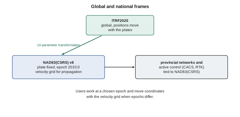
Canada's national frame is NAD83(CSRS), the North American Datum of 1983 in the Canadian Spatial Reference System. The original NAD83 of 1986 was a horizontal adjustment of classical observations, with a datum close to, but about 2 m from, the Earth's centre of mass. Canada redefined it in the 1990s as a three-dimensional, GNSS-based frame, keeping the NAD83 name and nearly the same coordinates but tying it rigorously to the ITRF through a 14-parameter transformation. Each time a new ITRF was adopted, a new version of NAD83(CSRS) followed. Version 8, adopted in 2024, is based on ITRF2020 at the reference epoch 2010.0, and the previous version, based on ITRF2014, was also at epoch 2010.0.
The transformation from ITRF to NAD83(CSRS) has translations of about a metre or two, rotations of tens of milliarcseconds, and rates. The rotation rates equal the rotation of the North American plate, with opposite sign, so that a point fixed on the stable plate keeps fixed NAD83(CSRS) coordinates while its ITRF coordinates change. The translations reflect NAD83's origin, which is about 2 m from the Earth's centre, kept so that NAD83(CSRS) coordinates stay close to those in older maps and records.
import math
# ITRF to NAD83(CSRS): a 14-parameter transformation (parameters approximately as published by NRCan for ITRF2014,
# reference epoch 2010.0; the ITRF2020 version differs only at the millimetre level).
mas = math.radians(1 / 3.6e6)
T0 = (1.0053, -1.9092, -0.5416)                 # m
R0 = (-26.7814, 0.4203, -10.9321)               # mas
D0 = 0.37                                       # ppb
Td = (0.0008, -0.0006, -0.0014)                 # m/yr
Rd = (-0.0667, 0.7574, 0.0511)                # mas/yr
Dd = -0.07                                      # ppb/yr
def geod2ecef(lat, lon, h, a=6378137.0, f=1 / 298.257222101):
    e2 = f * (2 - f); la, lo = math.radians(lat), math.radians(lon)
    N = a / math.sqrt(1 - e2 * math.sin(la) ** 2)
    return ((N + h) * math.cos(la) * math.cos(lo), (N + h) * math.cos(la) * math.sin(lo), (N * (1 - e2) + h) * math.sin(la))
def helmert(X, t):
    dt = t - 2010.0
    T = [T0[i] + Td[i] * dt for i in range(3)]
    R = [(R0[i] + Rd[i] * dt) * mas for i in range(3)]
    D = (D0 + Dd * dt) * 1e-9
    x, y, z = X
    return (x + T[0] + D * x - R[2] * y + R[1] * z,
            y + T[1] + R[2] * x + D * y - R[0] * z,
            z + T[2] - R[1] * x + R[0] * y + D * z)
lat, lon, h = 49.696730583, -112.827087889, 893.412
X = geod2ecef(lat, lon, h)
for t in (2010.0, 2026.84):
    Y = helmert(X, t)
    d = [b - a for a, b in zip(X, Y)]
    la, lo = math.radians(lat), math.radians(lon)
    e = -math.sin(lo) * d[0] + math.cos(lo) * d[1]
    n = -math.sin(la) * math.cos(lo) * d[0] - math.sin(la) * math.sin(lo) * d[1] + math.cos(la) * d[2]
    u = math.cos(la) * math.cos(lo) * d[0] + math.cos(la) * math.sin(lo) * d[1] + math.sin(la) * d[2]
    print(f"epoch {t:.2f}: NAD83(CSRS) minus ITRF  east {e:+.3f}  north {n:+.3f}  up {u:+.3f} m  (horizontal {math.hypot(e, n):.3f} m)")
print("The change between the two epochs is the plate motion that NAD83(CSRS) removes.")epoch 2010.00: NAD83(CSRS) minus ITRF east +1.213 north -0.628 up +0.478 m (horizontal 1.366 m) epoch 2026.84: NAD83(CSRS) minus ITRF east +1.513 north -0.462 up +0.456 m (horizontal 1.582 m) The change between the two epochs is the plate motion that NAD83(CSRS) removes.
The code applies parameters of the published size, approximately those NRCan gives for the ITRF2014 version, to CR1. At epoch 2010.0, NAD83(CSRS) differs from the ITRF by about 1.2 m east, 0.6 m south and 0.5 m up, 1.37 m horizontally. By late 2026, the horizontal difference has grown to about 1.58 m, because the ITRF coordinates have moved with the plate for almost 17 years while the NAD83(CSRS) coordinates have not. The change of about 0.3 m east and 0.17 m north is the plate motion of lesson 3 accumulated over the interval, which the time-dependent rotations remove.
Maintaining a national frame
A national frame is not computed once. The agency reprocesses the data of its active stations, often all of them from the beginning, whenever orbits, antenna models or software improve, and it re-estimates their positions and velocities. Campaign observations on passive monuments are adjusted into the frame as they arrive. Each reprocessing changes coordinates slightly, usually by millimetres, and the agency decides whether the changes are large enough to publish a new version or small enough to absorb as updates. Users notice only when versions change, but the work is continuous.
The Canadian Geodetic Survey works closely with provincial geodetic agencies, which maintain densification networks and set their own policies on which version and epoch of NAD83(CSRS) is official in their province. Those policies differ, because provinces adopt new versions on their own schedules. A surveyor working across a provincial boundary, or with records from different years, must check the version and epoch of each set of coordinates. The national agency and the provinces publish the transformations between versions so that this is always possible.
Consequences for users
For most users in Canada, the practical effect of a new NAD83(CSRS) version is small: a few millimetres to a centimetre or two in position on the stable part of the country, more in the west where deformation and data changes are larger. The bigger issue is the epoch. NAD83(CSRS) coordinates at epoch 2010.0 and at epoch 2002.0 or 1997.0 differ by the residual velocities over the interval, which can reach several centimetres vertically in areas of strong GIA. Legal surveys, engineering records and GIS data in Canada therefore increasingly carry both the version and the epoch, and the profession's standards for survey plans ask for the reference frame to be stated.
In both countries the same lesson applies. A frame change is mostly a data management task. The geodesy is done by the agencies; the surveyor's job is to know which frame every number is in and to convert it correctly when needed.
Access to the frame
Users reach NAD83(CSRS) in several ways. The Canadian Active Control System, CACS, is a network of continuously operating stations run by the Canadian Geodetic Survey, which define the frame most precisely. The Canadian Base Network, CBN, is a network of high-stability pillars and monuments observed repeatedly by GNSS campaigns. Provincial agencies maintain their own active and passive networks, and many commercial RTK networks broadcast corrections in NAD83(CSRS) at a stated epoch. The online service CSRS-PPP, met in GEOM-300, processes a user's own data with precise products and returns coordinates in ITRF and in NAD83(CSRS) at the epoch the user chooses.
| Element | Canada | Role |
|---|---|---|
| Active stations | CACS and provincial networks | Define the frame most precisely; continuous data |
| High-stability pillars | Canadian Base Network | Repeated campaigns; regional access |
| Processing service | CSRS-PPP | Coordinates from users' own data |
| Transformation tool | TRX | Between frames, versions and epochs |
| Velocity model | NAD83(CSRS) velocity grid | Moving coordinates between epochs |
Ellipsoidal heights in national frames
A frame change affects heights above the ellipsoid as well as horizontal positions. Because NAD83's origin is offset from the centre of mass, ellipsoidal heights in NAD83 differ from those in the ITRF by up to a metre or more, by an amount that varies smoothly across the continent. That matters for anyone who converts GNSS ellipsoidal heights to orthometric heights with a geoid model, since the geoid model must be expressed in the same frame as the ellipsoidal heights. A geoid model computed for the ITRF and applied to NAD83 heights, or the reverse, gives heights wrong by the frame difference.
Canada handles this by publishing its geoid models in NAD83(CSRS), so that h in NAD83(CSRS) minus N gives CGVD2013 heights. Users who obtain h in ITRF, for example from a precise point positioning result, must first transform it to NAD83(CSRS) at the right epoch. CSRS-PPP does this automatically when the user asks for NAD83(CSRS) output, which is one reason it is the safest route for most users.
The rule is simple: the ellipsoidal height, the geoid model and the resulting height must all belong to the same frame and epoch. Lesson 11 returns to the height side of that rule.
Other frames that users meet
WGS 84, the frame of GPS, is maintained by the United States Department of Defense and aligned with the ITRF to about a centimetre in its recent realizations. A GPS receiver's autonomous position is in WGS 84 by definition, but at the metre level of autonomous positioning it is indistinguishable from the ITRF, and many software packages treat WGS 84 and NAD83 as identical, which is wrong by a metre or two. Galileo, GLONASS and BeiDou have their own frames, also aligned with the ITRF. For precise work, the relevant frame is that of the orbits used in processing, which for IGS products is IGS20, aligned to ITRF2020.
Older frames remain in records: NAD27, based on the Clarke 1866 ellipsoid and a classical adjustment, differs from NAD83 by tens to hundreds of metres; the first NAD83 adjustments, before GPS, by up to a metre from later versions. Transformations between them are grid-based, because the old networks were distorted in ways that no simple formula captures.
In Canada, NTv2 grids transform between NAD27 and NAD83, and provinces publish their own grids between older realizations of NAD83 and NAD83(CSRS). In Alberta, legacy survey coordinates may be in several such realizations, and the provincial survey control network documents which.
Worked problem
Plate motion between frames
A point's ITRF coordinates move 17.6 mm per year. A plate-fixed national frame agreed with the ITRF at epoch 2010.0. How far apart are the two at epoch 2030.0, ignoring other differences?
Show solution
- \[\Delta t = 20\ \text{yr}\]
- \[d = 17.6 \times 20 = 352\ \text{mm}\]
Answer: About 0.35 m, growing steadily with time.
Coulee Geomatics: CR1 in the national frame
CR1's application to the national network asks for its NAD83(CSRS) coordinates at epoch 2010.0, its ITRF2020 coordinates at a recent epoch, and its site log. Theo computes the first from three months of data with CSRS-PPP and the second from the same data, and checks that the difference between them agrees with TRX to a millimetre. Once accepted, CR1's official coordinates will come from the national processing, and the firm will use those, not its own, for the district's work. Ruth asks for one more check before submission: a comparison of CR1's CSRS-PPP coordinates with the nearest CACS and CBN stations, processed as baselines, to confirm that the pillar agrees with the national network at the centimetre level before it becomes part of it. Theo's baselines close to within 4 mm horizontally and 9 mm vertically, well inside the tolerance the firm set itself, and the comparison goes into the application as supporting evidence.
Common mistakes
MistakeTreating WGS 84 and NAD83 as identical.
InsteadThey differ by a metre or two; use the published transformation.
MistakeAssuming a national frame equals the ITRF.
InsteadIt is plate-fixed and differs by an amount that grows with time.
MistakeCombining coordinates from different versions of a national frame.
InsteadTransform to one version and epoch first.
MistakeUsing a simple formula between NAD27 and NAD83.
InsteadUse the official grid-based transformation.
Summary and key terms
- National frames tie to the ITRF but keep coordinates nearly fixed on the stable plate.
- NAD83(CSRS) is Canada's frame; version 8, adopted in 2024, is based on ITRF2020 at epoch 2010.0.
- A 14-parameter, time-dependent transformation links ITRF and NAD83(CSRS).
- CACS, the CBN, provincial networks and CSRS-PPP give access to the frame.
- TRX and the velocity grid move coordinates between versions and epochs.
- WGS 84, NAD27 and older NAD83 versions must be transformed, not assumed equal.
- NAD83(CSRS)
- Canada's national three-dimensional frame, tied to the ITRF by a time-dependent transformation.
- CACS
- The Canadian Active Control System of continuously operating stations.
- CBN
- The Canadian Base Network of high-stability monuments.
- TRX
- The NRCan tool for transforming coordinates between frames and epochs.
- Plate-fixed frame
- A frame that rotates with a chosen tectonic plate.
- NTv2
- A grid format for transformations between older and newer datums.
Practice problems
Work each problem on paper first, then reveal the answer to check.
Why does the difference between a plate-fixed frame and the ITRF grow with time?
Show answer
ITRF coordinates move with the plate; the plate-fixed coordinates do not.
What is the origin of NAD83 relative to the Earth's centre of mass?
Show answer
About 2 m away, a legacy of its original definition.
Which NAD83(CSRS) version is based on ITRF2020?
Show answer
Version 8, adopted in 2024.
Why are transformations from NAD27 grid-based?
Show answer
The old networks had irregular distortions.
A precise point positioning result is in ITRF2020 at epoch 2026.84. What must be done before comparing it with national control?
Show answer
Transform it to the national frame and epoch.
Lesson quiz · 5 questions
Score 60% or more to complete this lesson.
Create a free account to save your progress, take quizzes and earn a certificate.