
GEOM-420 · Lesson 4 of 12 · 20 min
Earthwork quantities
Moving earth is often the largest single cost on a road or site job, and the contractor is paid by the cubic metre. The quantities in the tender come from the designer's model; the quantities that are paid come from the surveyor's measurements of what was actually moved. Both depend on the same methods: cross-sections at regular stations, areas of cut and fill on each section, volumes between sections, and a running balance that shows where material can be moved from cut to fill and where it must be brought in or hauled away. This lesson covers those methods, the corrections that make them honest, and the surface-to-surface methods that modern software uses.
Cross-sections
A cross-section is a slice through the ground and the design at right angles to the alignment, at a given station. The original ground line comes from the design survey's terrain model or from field shots taken across the line; the design template comes from the road's typical section: the subgrade width, the cross slope, the side slopes in cut and fill, and the ditches. Where the template is below the ground there is cut; where it is above there is fill. The area of each, in square metres, is computed from the coordinates of the section's outline, usually by the same shoelace formula used for parcel areas in GEOM-410.
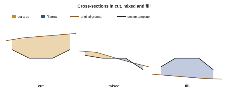
For the highway approach near the canal bridge, Theo cuts sections every 20 m from 2+600 to 2+800, with extra sections where the ground changes sharply and at the beginning and end of each cut and fill. Field crews check a few sections on the ground before construction, because the end areas are only as good as the original ground they are measured from.
Volumes between sections
The simplest estimate of the volume between two sections is the average of their end areas times the distance between them. The average end area method is used almost everywhere for payment, because it is simple and agreed, but it is exact only when the two end areas are equal. When they differ, the true shape between them is a prismoid, and the prismoidal formula, which uses a middle area as well as the two ends, gives the exact volume for a solid whose sections change smoothly.
The middle area \(A_m\) is the area of a section halfway between the two ends; it is not the average of the end areas, but must be computed from the dimensions at the middle. The difference between the two volumes is the prismoidal correction. It is usually small, and it is negative for sections that grow or shrink in both width and depth, which is why the average end area method tends to overestimate.
Earthwork in Canada is measured in cubic metres. Contracts usually specify that the average end area method is used for payment, with or without a prismoidal correction, and agree in advance on the section interval and on who provides the original ground.
Shrink and swell
A cubic metre of earth is not the same amount of material in every state. In the ground, it is bank volume. Dug and loaded into a truck, it swells and takes up more room, the loose volume. Placed and compacted in a fill, it usually takes less room than it did in the bank, the compacted volume. Rock is the exception: it swells and stays swollen. The ratios depend on the soil and the compaction, and the geotechnical report gives them. For balancing cut against fill, the cut volumes are multiplied by a shrinkage factor, so that both are in compacted terms.
For the clay and silt of the coulee slopes, the geotechnical report gives a factor of 0.88: each bank cubic metre of cut makes 0.88 of compacted fill. That 12 % loss is a large effect on a job with tens of thousands of cubic metres, and getting it wrong is a common reason why a job that balanced on paper needs borrow material at the end.
The mass haul diagram
The mass haul diagram is the earthwork planner's tool. Its ordinate at each station is the running total of adjusted cut minus fill from the start of the job: it rises through cut, falls through fill, peaks where cut changes to fill, and dips where fill changes to cut. Any horizontal line drawn across it cuts the curve at two points between which cut and fill balance, and the material can be moved from one to the other. The final ordinate tells whether the whole job has a surplus to waste or a shortage to borrow.
# Earthwork for the highway approach: average end area, prismoidal correction and mass haul (metres)
sta  = [2600, 2620, 2640, 2660, 2680, 2700, 2720, 2740, 2760, 2780, 2800]
cut  = [12.4, 18.6, 25.1, 30.8, 22.5, 10.2,  3.1,  0.0,  0.0,  0.0,  0.0]   # end areas, m2
fill = [ 0.0,  0.0,  0.0,  0.0,  1.8,  6.4, 14.9, 24.3, 31.0, 27.6, 16.2]
shrink = 0.88                 # 1 m3 of cut makes 0.88 m3 of compacted fill
mass, tot_c, tot_f = 0.0, 0.0, 0.0
print(" chainage   cut m3   fill m3   adj cut   mass ordinate")
print(f"{sta[0]:6d}        -         -         -          0")
for i in range(1, len(sta)):
    d = sta[i] - sta[i - 1]
    vc = d * (cut[i - 1] + cut[i]) / 2
    vf = d * (fill[i - 1] + fill[i]) / 2
    mass += vc * shrink - vf; tot_c += vc; tot_f += vf
    print(f"{sta[i]:6d}  {vc:7.1f}  {vf:8.1f}  {vc*shrink:8.1f}  {mass:10.1f}")
print(f"total cut {tot_c:.0f} m3 (bank), total fill {tot_f:.0f} m3, balance {mass:+.0f} m3 after shrinkage")

# Prismoidal check on the 2620-2640 segment, with a measured middle area of 21.6 m2
A1, Am, A2, d = 18.6, 21.6, 25.1, 20
v_ea = d * (A1 + A2) / 2; v_pr = d * (A1 + 4 * Am + A2) / 6
print(f"average end area {v_ea:.1f} m3, prismoidal {v_pr:.1f} m3, correction {v_pr - v_ea:+.1f} m3")chainage cut m3 fill m3 adj cut mass ordinate 2600 - - - 0 2620 310.0 0.0 272.8 272.8 2640 437.0 0.0 384.6 657.4 2660 559.0 0.0 491.9 1149.3 2680 533.0 18.0 469.0 1600.3 2700 327.0 82.0 287.8 1806.1 2720 133.0 213.0 117.0 1710.1 2740 31.0 392.0 27.3 1345.4 2760 0.0 553.0 0.0 792.4 2780 0.0 586.0 0.0 206.4 2800 0.0 438.0 0.0 -231.6 total cut 2330 m3 (bank), total fill 2282 m3, balance -232 m3 after shrinkage average end area 437.0 m3, prismoidal 433.7 m3, correction -3.3 m3
The table shows the approach in cut up to about 2+700, peaking in the mass haul at 1,806 m³, and then in fill to 2+800. In total there are 2,330 m³ of bank cut and 2,282 m³ of fill. After shrinkage, the cut makes only 2,050 m³ of compacted fill, so the job ends 232 m³ short. The contractor will need borrow, or the designers may lower the grade slightly on the fill side; Ruth sends the table to the engineer with that note. The prismoidal check on the 2+620 to 2+640 segment, with a measured middle area of 21.6 m², gives 433.7 m³ instead of 437.0 m³, a correction of −3.3 m³ or under 1 %.
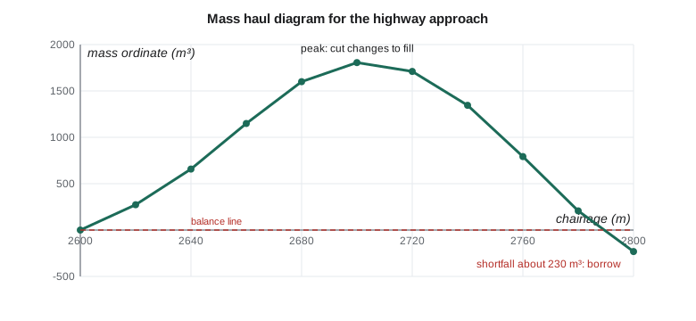
On a longer job the mass haul diagram also shows haul distance. The horizontal distance between the two points where a balance line crosses the curve is the longest haul for that balanced section, and the area between the curve and the line is the total haul in cubic metre-stations. Contracts often include a free-haul distance, within which hauling is part of the excavation price, and pay overhaul beyond it. The surveyor's diagram is then the basis for payment, and both sides check it.
Worked problem
Average end area and prismoidal volume
Two cut sections 25 m apart have areas 32.0 m² and 18.0 m². The middle section, computed from its own dimensions, is 24.0 m². Find the average end area and prismoidal volumes.
Show solution
- \[V_{\text{ea}} = \frac{25}{2}(32.0 + 18.0) = 625.0\ \text{m}^3\]
- \[V_{\text{pr}} = \frac{25}{6}(32.0 + 4 \times 24.0 + 18.0) = 608.3\ \text{m}^3\]
Answer: The average end area overestimates by about 3 %, a typical size for sections that change sharply.
Surface-to-surface volumes
Modern software can also compute volumes directly between two terrain models: the original ground and the design, or the ground before and after a day's excavation. It builds a third surface of differences and integrates it, triangle by triangle or over a fine grid. The result does not depend on a section interval, and it handles irregular shapes such as stockpiles, ponds and the pump station's excavation better than sections do. Its accuracy depends on the density and quality of both surfaces, and especially on breaklines at the edges of the work.
For payment, surface methods are increasingly accepted, but a contract must say so, and both parties must agree on the surfaces. Ruth's crew uses surface methods for progress estimates on the pump station's excavation, where the shape is too irregular for sections, and drone photogrammetry or lidar (GEOM-310, GEOM-350) for the stockpiles of topsoil and gravel. For the highway, the contract specifies sections every 20 m and average end area, so that is what is used for payment, and the surface method is a cross-check.
Field measurement of quantities
Quantities for payment must be measured, not assumed from the design. Before stripping, the crew surveys the original ground, or the contract accepts the design survey as the original ground; after stripping topsoil, it surveys again, so that topsoil and common excavation can be paid separately; after excavation and before backfill, it surveys the final surface. Each survey is done from the same control, with the same coding and the same section stations, so that the surfaces can be compared. Disputes are rare when the surveys are well documented, because both sides can see exactly what was measured and when.
Excavations are dangerous places for survey crews. Before anyone enters a trench or the pump station's pit to take a shot, the sides must be sloped, benched or shored as the Alberta OHS Code's excavation rules require, and the crew stays clear of the swing radius of excavators and the path of haul trucks. A survey pole held at the edge of an excavation by someone standing well back is better than a perfect shot taken from the bottom of an unprotected trench.
Topsoil, rock and unsuitable material
Not all excavation is the same, and the contract usually pays for it differently. Topsoil is stripped first and stockpiled for later reuse on slopes and ditches, so its volume is measured separately: the crew surveys the ground before and after stripping, or the contract sets a nominal stripping depth. Rock excavation costs far more than common excavation, so where the geotechnical report expects rock, the crew surveys the top of rock once it is exposed and computes rock volumes separately. Unsuitable material, such as wet clay or organic soil that cannot be used in a fill, is removed below the design subgrade and replaced, and the survey must record the bottom of every such excavation before it is backfilled.
Each of these classes needs its own surfaces and its own volumes, and the classification must be agreed on site with the contractor and the engineer's inspector when the material is exposed, not argued about afterwards. Ruth's crew photographs every exposed rock surface and every unsuitable excavation with a scale and a location reference, and the inspector initials the field record. That small habit prevents most of the disputes that earthwork payment can cause.
Borrow pits have their own measurement too. When the approach needs the 232 m³ of borrow shown by the mass haul diagram, the material will come from a pit the contractor opens nearby or from a commercial source. If it comes from a pit, the crew surveys the pit before and after, and the volume removed, adjusted by the shrinkage factor, should agree with the shortfall the diagram predicts. A large difference in either direction means that something in the quantities or the factors needs to be looked at again.
Common mistakes
MistakeAveraging end areas to get the middle area for the prismoidal formula.
InsteadCompute the middle area from the dimensions at the middle section.
MistakeBalancing bank cut directly against compacted fill.
InsteadApply the shrinkage (or swell) factor so both are in the same terms.
MistakeMeasuring final quantities from the design rather than the ground.
InsteadSurvey the ground before and after each stage of work.
MistakeUsing sections too far apart over rough ground.
InsteadAdd sections at breaks in the ground and at the ends of each cut and fill.
Summary and key terms
- Cross-sections give end areas of cut and fill at each station.
- Average end area volume is d(A1 + A2)/2; the prismoidal formula adds a middle area and is exact for smooth solids.
- Bank, loose and compacted volumes differ; shrinkage and swell factors convert between them.
- The mass haul diagram's ordinate is the running total of adjusted cut minus fill; its end value shows surplus or shortage.
- Surface-to-surface methods compute volumes between terrain models and suit irregular shapes.
- Payment quantities come from documented surveys of the ground before and after each stage.
- End area
- The area of cut or fill on a cross-section.
- Average end area method
- Volume between two sections as the mean of their areas times the distance between them.
- Prismoidal formula
- Volume as d/6 times the sum of the end areas and four times the middle area.
- Shrinkage factor
- The ratio of compacted fill volume to the bank volume it came from.
- Mass haul diagram
- A graph of cumulative adjusted cut minus fill along the alignment.
- Borrow
- Material brought in from outside the job to make up a shortage of fill.
- Free haul
- The haul distance included in the excavation price, beyond which overhaul is paid.
Practice problems
Work each problem on paper first, then reveal the answer to check.
Sections 20 m apart have cut areas 15.0 and 21.0 m². What is the average end area volume?
Show answer
20 × 36.0/2 = 360.0 m³.
A cut of 5,000 m³ bank with a shrinkage factor of 0.85 is placed in a fill of 4,500 m³. Is there a surplus or a shortage?
Show answer
5,000 × 0.85 = 4,250 m³ compacted, a shortage of 250 m³.
What does a peak in the mass haul diagram mean?
Show answer
A point where cut changes to fill.
Why must the middle area in the prismoidal formula be measured rather than averaged?
Show answer
Averaging the end areas would give the same result as the average end area method.
When are surface-to-surface volumes better than sections?
Show answer
For irregular shapes such as stockpiles and pits, given good surfaces with breaklines.
Lesson quiz · 5 questions
Score 60% or more to complete this lesson.
Create a free account to save your progress, take quizzes and earn a certificate.