
ARCH-401 · Lesson 3 of 12 · 22 min
Site and urban role
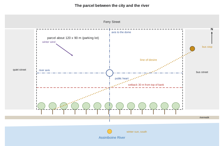
In week three the students return to the river with tape measures, a camera, a level and a thermos. Navarro wants a site analysis that goes beyond the boundaries of the parcel. 'A house sits on its lot,' she says. 'A civic building sits in its city. Your site is the parcel, but your subject is everything the building will be seen from, walked to and remembered with.' The parcel is a city-owned surface parking lot of about 120 × 90 m, or about 10,800 m², on the north bank of the Assiniboine River, a short walk west of The Forks. Its long side faces the river to the south; its short sides face a quiet street on the west and a busier street with a frequent bus route on the east; and its north side faces the city, across a street that the students call Ferry Street, with offices and apartments beyond.
The river
The river is the site's great asset and its great constraint. It gives the building a view, a southern exposure across open water, a path for walkers, runners and skaters, and a long history as a route and a meeting place. The Forks, where the Red and Assiniboine meet, has been a meeting and trading place for Indigenous peoples for about 6,000 years, and later for fur traders, railway workers and the city that grew around them. Navarro asks the students to treat this history as part of the site, and to learn it from the people whose history it is, not only from plaques.
The river also floods. The Red River flood of 1997 is the city's reference event, and the city requires buildings near the rivers to set their main floors above a design flood level and to keep a setback from the top of the riverbank, where the soil is unstable and slides are common. For this studio, Navarro gives the class two rules from the city's riverbank planners: a setback of 30 m from the top of the bank, which keeps the riverwalk, its trees and a strip of park public; and a main floor at least 1.2 m above the existing grade at the river edge, which the students can achieve by raising the building on a low plinth or by letting the ground floor step down toward the river in a way that floods gracefully.
Reading the city side
On the city side, the parcel is a gap in the street wall. The buildings along Ferry Street are mostly six to twelve storeys, with shops and lobbies at the ground floor; the parking lot is a hole in the middle of them, and pedestrians cross it diagonally on worn paths from the bus stop on the east street to the river. Wren photographs the paths and maps them: the strongest runs from the bus stop to a gap in the riverwalk trees near the parcel's south-west corner, where people go down to the water. She reads it as a line of desire, a route the public has already chosen, and resolves to keep it.
Two axes cross the parcel. One runs north-south along a street that ends at the river, aligned with a view of the dome of the Legislative Building to the north. The other runs east-west along the river and the riverwalk. Where they cross, roughly in the middle of the parcel, Wren marks the place for the building's public heart. Navarro reminds her that axes are a classical tool and that a civic building can use them without being classical: an axis can be a view, a path or a line of light rather than a symmetrical plan.
Sun, wind and snow
The climate study is short because the students have done it before, but its consequences are large. The winter wind comes mostly from the north-west and the north, across the city side of the parcel, and it accelerates in the gaps between buildings. The sun comes from the south, across the river, which means the river side of the building will have the best light and the coldest views of open water, while the city side will be in shadow for much of the winter. Snow drifts behind obstacles and against walls facing away from the wind, which on this site means along the river side of any building that is long east to west.
Wren checks two things with a short script. She wants the reading room to look at the river, and the riverwalk is lined with tall trees that the city will not let her cut. Will a seated reader see the water over the trees, through them or not at all? And she wants a sheltered terrace on the river side in winter; how far does a roof edge of a given height shade the terrace at noon at the winter solstice?
# Does the reading room keep its view to the river? Check the sight line over the riverwalk trees
import math
eye = 1.2        # eye height of a seated reader above the river terrace, m
tree = 14      # height of the trees along the riverwalk, m
dist_tree = 40   # distance from the window wall to the tree line, m
for floor in (0, 1, 2):
    h = eye + floor * 5.0                      # eye height on each reading floor
    ang = math.degrees(math.atan2(tree - h, dist_tree))
    sees = "over the trees" if h > tree else "through the trunks, under the canopy"
    print(f"floor {floor}: eye at {h:.1f} m, tree tops {ang:+.1f} degrees from level, view {sees}")
# winter noon sun on the river terrace (south-facing)
lat = 49.9
alt = 90 - lat - 23.44
print(f"winter noon sun altitude {alt:.1f} degrees; a {6} m roof edge shades {6 / math.tan(math.radians(alt)):.1f} m of terrace")floor 0: eye at 1.2 m, tree tops +17.7 degrees from level, view through the trunks, under the canopy floor 1: eye at 6.2 m, tree tops +11.0 degrees from level, view through the trunks, under the canopy floor 2: eye at 11.2 m, tree tops +4.0 degrees from level, view through the trunks, under the canopy winter noon sun altitude 16.7 degrees; a 6 m roof edge shades 20.0 m of terrace
The results change her thinking. Even from the second reading floor, a seated reader's view rises toward the treetops, so no floor sees over the canopy: the view is through the trunks and under the canopy, to the water. That suggests a reading room low to the ground, perhaps a single tall room, with glass that starts close to the floor and long views between the trunks, rather than a tower of reading floors trying to see over the trees. And the winter sun at noon is so low, about 17 degrees, that a roof edge 6 m above the terrace shades about 20 m of it. A deep roof over the terrace would make it dark all winter; a terrace in the sun needs a low or no roof on its south side, and shelter from the north-west wind behind the building itself.
The building's urban role
Navarro asks each student to write a paragraph on the building's urban role: not what it contains but what it does for the city around it. Callum writes that his building should be a landmark seen from the bridges, a tall glass volume that glows at night. Joon-ho writes that his should complete the street wall on Ferry Street and hold a quiet courtyard behind it. Ingrid writes that hers should bridge the riverwalk and make the river and the city one continuous public ground. Wren writes that hers should be a public room between the city and the river: a building you walk through on your way to the water, which happens to contain a library.
The four paragraphs are all defensible, and Navarro's critique is about consequences. A landmark tower competes with the Legislative Building on the axis and puts most of its readers far from the ground. A completed street wall gives the city side a proper face but may turn the building's back to the river. A bridge over the riverwalk makes a strong gesture but must touch the bank inside the setback, where the soil is weakest. Wren's public room keeps the line of desire and uses both axes, but it risks being a long, low building that is hard to see from the city side. 'Every urban role has a price,' Navarro says. 'Know what yours costs, and pay it on purpose.'
Wren decides to pay hers with a single strong move on the city side: the building will lift its roof at the end of the north-south axis, so that from Ferry Street the forum's entrance is a tall, deep porch, lit at night, framing a view straight through the building to the river. The roof will then fall in a long, low line toward the water, so that from the river the building sits below the canopy of the riverwalk trees.
Worked problem
Shading a terrace
On a site at 50 degrees north, the noon sun at the winter solstice has an altitude of about 16.6 degrees. How far does a roof edge 4 m above a terrace throw its shadow at that time?
Show solution
- Shadow length = height / tan(altitude).
- tan(16.6) = about 0.298.
- Shadow = 4 / 0.298 = about 13.4 m.
Answer: About 13 m: the low winter sun makes even a modest roof edge cast a long shadow.
Exercise 3: site and urban role
- Map the paths people already take across your site, and decide which you will keep.
- Mark the axes, views and edges that tie the site to the city, and choose where the building's public heart should be.
- Study sun, wind and snow, and test with a short calculation one view and one shadow that matter to your design.
- Write a paragraph on your building's urban role, and list what it will cost the design.
Self-check
- Have you respected the riverbank setback and the flood level?
- Have you learned the site's history from the people whose history it is?
- Can you explain what your building does for the city around it, apart from what it contains?
The riverbank and the ground
Before leaving the site, Navarro asks Hamid Rezaei, the civil engineering student from last term's integrated studio, to walk the riverbank with the class. He points out the signs of an unstable bank: trees leaning toward the water, cracks in the path running parallel to the river, and the retaining walls the city has built in several places along the Assiniboine to stop slides in the soft lake clay. A heavy building close to the top of the bank adds load to the soil that is most likely to slide; that is why the setback exists, and why the building's heaviest parts, the hall and its concrete roof, should sit as far from the bank as the plan allows.
The ground affects the plan in two more ways. Winnipeg's lake clay swells and shrinks with moisture and is poor for shallow footings, so a building of this size will stand on piles, and the ground floor will be a structural slab spanning between grade beams with a void below, which also lets the floor rise above the flood level without filling the site. And the river's spring rise means that any space below the main floor, such as a basement for plant or archives, must be watertight and protected, which is expensive; Wren decides early that the archives and the main plant will be above the flood level, not below ground.
Rezaei also reminds the class about stormwater. A parking lot of this size sends all of its rain straight to the river, carrying oil and salt. A building with planted roofs, permeable paving on the terrace and a rain garden at the bottom of the slope toward the river can hold back and clean most of it, which the city's riverbank planners will welcome. Wren draws a small rain garden at the south-west corner, where the line of desire reaches the water.
Common mistakes
MistakeStudying only the parcel.
InsteadStudy everything the building will be seen from, walked to and remembered with.
MistakeIgnoring the paths people already take.
InsteadMap lines of desire and keep the ones that serve the public.
MistakeAssuming upper floors will see over the trees.
InsteadCheck the sight line; low views between trunks may be better.
MistakePutting a deep roof over a winter terrace.
InsteadCheck the winter noon shadow; a sunny terrace needs an open south side.
MistakeChoosing an urban role without counting its cost.
InsteadWrite what the role gives the city and what it takes from the design.
Summary and key terms
- The site is the parcel; the subject is the city around it, the river and its history.
- The riverbank setback of 30 m and a main floor 1.2 m above the river-edge grade come from the flood and bank-stability rules set for the studio.
- A worn path from the bus stop to the river and two crossing axes locate the building's public heart.
- Readers will see the river through the trunks, not over the trees; the low winter sun shades deep terraces.
- Wren's urban role is a public room between city and river, announced by a tall porch on the city axis.
- Line of desire
- A path worn by people choosing their own route across open ground.
- Axis
- A line organizing views, paths or spaces, often tying a building to its city.
- Setback
- A required distance between a building and a boundary, street or riverbank.
- Urban role
- What a building does for the city around it, beyond its contents.
- Design flood level
- The water level that floors and openings must stay above.
Practice problems
Work each problem on paper first, then reveal the answer to check.
A roof edge 6 m above a terrace, with the winter noon sun at 16.7 degrees: how long is the shadow?
Show answer
6 / tan 16.7 = about 20 m.
Why does Wren prefer a low, tall reading room?
Show answer
Readers see the river through the trunks; upper floors do not see over the trees.
What is the riverbank setback in this studio?
Show answer
30 m from the top of the bank.
What did Navarro say about the urban role of a building?
Show answer
Every role has a price; know it and pay it on purpose.
From which direction does the winter wind mostly come?
Show answer
The north-west and north.
How does Wren announce the building on the city side?
Show answer
With a tall, lit porch at the end of the north-south axis framing a view to the river.
Lesson quiz · 5 questions
Score 60% or more to complete this lesson.
Create a free account to save your progress, take quizzes and earn a certificate.