
AERO-350 · Lesson 9 of 12 · 25 min
Navigation: GNSS, VOR and ILS
Navigation answers two questions: where the aircraft is, and how to get where it is going. For most of aviation's history the answers came from ground radio beacons, and pilots flew from one beacon to the next along airways. Today most navigation uses satellites and onboard computers, and aircraft fly precise paths defined only by coordinates. But the ground aids have not disappeared: the instrument landing system still guides most precision approaches, and VOR and DME stations remain as a backup network. This lesson explains how each works, what it can and cannot do, and how performance-based navigation ties them together. GEOM-300 covered how satellite positioning itself works; here the focus is on how aircraft use it.
VOR and DME
A VHF omnidirectional range, VOR, transmits in the band 108 to 117.95 MHz. It sends two 30 Hz signals: a reference whose phase is the same in all directions and a variable signal whose phase changes with the bearing from the station. The aircraft's receiver compares the phases and determines the radial, the magnetic bearing from the station, on which it lies. Accuracy is typically within a couple of degrees, and the program shows what that means: a 2 degree error puts the aircraft about 0.2 NM off track 5 NM from the station but more than 2 NM off at 60 NM. VOR guidance is therefore good for airways near the station but poor far from it.
Distance measuring equipment, DME, is usually co-located with a VOR. The aircraft's interrogator sends pulse pairs, the ground transponder replies after a fixed delay, and the time gives the slant range, the straight-line distance to the station. Slant range differs from ground distance when the aircraft is high and close: directly over a station at 3000 m, the DME reads about 1.6 NM. Pairs of DME ranges also give a position fix, and DME-DME updating is still used by flight management systems in areas with dense ground stations.
The instrument landing system
The instrument landing system, ILS, guides aircraft down to the runway in low visibility. A localizer antenna array beyond the far end of the runway transmits in the band 108.1 to 111.95 MHz; two lobes modulated at 90 and 150 Hz overlap along the runway centreline, and the receiver measures the difference in their depths of modulation to find whether the aircraft is left or right. A glide slope antenna beside the runway, transmitting in the UHF band near 330 MHz, does the same in the vertical plane, usually along a 3 degree path. Marker beacons or DME give distance checks along the approach.
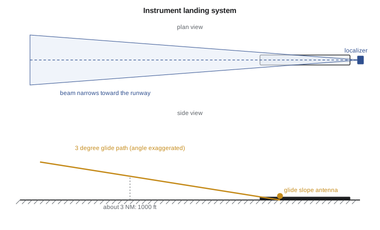
The program prints the height on a 3 degree glide path with a threshold crossing height of about 50 ft: about 1000 ft at 3 NM and about 1640 ft at 5 NM. Pilots use the rule of thumb that a 3 degree path descends about 300 ft per nautical mile. The localizer's course width is set so that full-scale deflection is a few degrees each side; at 5 NM, half-scale is about 200 m from the centreline, and the beam becomes more sensitive closer to the runway.
| Approach category | Typical decision height | Typical runway visual range | Notes |
|---|---|---|---|
| ILS Category I | 200 ft | about 550 m | Most common; standard aircraft equipment |
| ILS Category II | 100 ft | about 300 m | Requires special aircraft and crew approval |
| ILS Category III | Below 100 ft or none | down to about 75 m or less | Autoland or head-up guidance; special approval |
| RNP approach with LPV minima | as low as 200 ft | similar to Category I | Uses satellite-based augmentation |
| RNP approach with LNAV minima | Minimum descent altitude, higher | higher | Lateral guidance only |
Satellite navigation in aircraft
GNSS receivers certified for aviation must do more than compute a position. They must know when their position cannot be trusted. Receiver autonomous integrity monitoring, RAIM, uses redundant satellites to check the solution and to detect and exclude a faulty one, alerting the crew if the integrity needed for the current phase of flight is not available. Satellite-based augmentation systems, SBAS, add corrections and integrity information broadcast from geostationary satellites. In North America the system is the FAA's Wide Area Augmentation System, WAAS, which also serves Canadian airspace; NAV CANADA publishes approaches that use it. With SBAS, approaches with localizer performance with vertical guidance, LPV, can reach decision heights as low as 200 ft without any ground equipment at the airport.
This matters enormously for aircraft like the Tern, which serves small airports in northern Manitoba and Nunavut where an ILS would never be installed. An LPV or other RNP approach needs only a published procedure, a database in the aircraft and a certified receiver. GNSS also provides the time reference and position for the surveillance systems of Lesson 10, so its loss affects more than navigation.
GNSS signals are weak and can be disrupted by interference. Unintentional interference from faulty equipment, and deliberate jamming and spoofing in some regions, have become a serious concern for aviation in recent years. Aircraft defences are defensive: crews are trained to recognise anomalies such as position jumps and disagreement with inertial or radio data, flight management systems compare sources, and the inertial blending of Lesson 8 carries the aircraft through outages. Authorities in both countries publish notices about known interference, and keeping a backup network of VOR and DME stations is partly for this reason.
Performance-based navigation
Performance-based navigation, PBN, defines navigation by the accuracy, integrity and continuity an operation needs, rather than by the equipment. An RNAV specification such as RNAV 1 requires the aircraft to stay within 1 NM of the path 95 percent of the time. An RNP specification adds onboard performance monitoring and alerting: the aircraft must tell the crew if it cannot meet the requirement. RNP approaches, RNP AR approaches with curved paths and very small containment values in difficult terrain, and RNP 4 or RNP 2 oceanic and remote routes all fall under PBN.
The accuracy is measured as total system error, the combination of path definition error in the database, navigation system error in the position estimate, and flight technical error, the pilot's or autopilot's deviation from the path. These are combined by root-sum-square as in Lesson 4.
# Navigation geometry: height on a 3 degree glide path, cross-track error from a VOR or localizer
# angle error, DME slant range, and a check of total system error against an RNP value.
import math
gs, tch = 3.0, 15.0                    # glide path angle deg, threshold crossing height m (about 50 ft)
print("distance to threshold   height on glide path")
for d_nm in (10, 5, 3, 1, 0.5):
    d = d_nm * 1852
    h = tch + d * math.tan(math.radians(gs))
    print(f"   {d_nm:5.1f} NM {d:8.0f} m     {h:6.0f} m  ({h*3.281:5.0f} ft)")
# VOR: a 2 degree error in the radial is a growing cross-track distance
for r_nm in (5, 20, 60):
    print(f"VOR 2 deg error at {r_nm:3d} NM: {r_nm*1852*math.tan(math.radians(2))/1852:.2f} NM off track")
# Localizer: full scale is roughly 2.5 deg each side; deviation in metres at 5 NM for half scale
print(f"localizer half-scale (1.25 deg) at 5 NM: {5*1852*math.tan(math.radians(1.25)):.0f} m from the centreline")
# DME slant range: the aircraft overhead at 3000 m reads that height, not zero
h, ground = 3000.0, 0.0
print(f"DME directly over the station at {h:.0f} m: {math.hypot(h, ground)/1852:.2f} NM slant range")
# RNP 1 check: total system error from path definition, flight technical and navigation system errors
pde, fte, nse = 0.05, 0.50, 0.10       # NM, one-sigma-like values (illustrative)
tse = math.sqrt(pde**2 + fte**2 + nse**2)
print(f"\ntotal system error {tse:.2f} NM; RNP 1 needs it within 1 NM 95 % of the time -> "
      + ("meets" if 2 * tse <= 1.0 else "does not meet") + f" (2 x TSE = {2*tse:.2f} NM)")
fte_ap = 0.25                           # flying the path with the autopilot or flight director coupled
tse2 = math.sqrt(pde**2 + fte_ap**2 + nse**2)
print(f"with the autopilot coupled: 2 x TSE = {2*tse2:.2f} NM -> " + ("meets" if 2 * tse2 <= 1.0 else "does not meet"))distance to threshold height on glide path
10.0 NM 18520 m 986 m ( 3234 ft)
5.0 NM 9260 m 500 m ( 1641 ft)
3.0 NM 5556 m 306 m ( 1005 ft)
1.0 NM 1852 m 112 m ( 368 ft)
0.5 NM 926 m 64 m ( 208 ft)
VOR 2 deg error at 5 NM: 0.17 NM off track
VOR 2 deg error at 20 NM: 0.70 NM off track
VOR 2 deg error at 60 NM: 2.10 NM off track
localizer half-scale (1.25 deg) at 5 NM: 202 m from the centreline
DME directly over the station at 3000 m: 1.62 NM slant range
total system error 0.51 NM; RNP 1 needs it within 1 NM 95 % of the time -> does not meet (2 x TSE = 1.02 NM)
with the autopilot coupled: 2 x TSE = 0.55 NM -> meetsThe last part of the program is a lesson the Tern's team learned in a simulator session. With a hand-flown flight technical error of 0.5 NM, the total system error reaches about 0.51 NM, and twice that, a rough 95 percent value, slightly exceeds RNP 1. Coupling the autopilot or following the flight director halves the flight technical error and brings the total well within the requirement. The navigation system was never the problem; the pilot's tracking was. Sam Littlechild, the test pilot, now insists that RNP procedures on the Tern be flown coupled whenever possible, and the flight manual says so.
Databases and the FMS
Every RNAV or RNP procedure depends on the navigation database: the coordinates of waypoints, the path terminators that define each leg, altitude and speed constraints and the approach geometry. Databases are updated on a fixed 28 day cycle known as AIRAC, and an aircraft flying with an out-of-date database may fly the wrong path. Database suppliers and the aircraft's data loading process must meet quality standards, because a corrupted waypoint is as dangerous as a faulty receiver. Lesson 11 returns to the flight management system that uses the database to build and fly the route.
Worked problem
Height on the glide path
How high should an aircraft be 4 NM from the threshold on a 3 degree glide path with a threshold crossing height of 50 ft?
Show solution
- \(h = 50 + 4 \times 6076 \times \tan 3^\circ = 50 + 24\,304 \times 0.0524 = 50 + 1274 = 1324\) ft.
Answer: About 1320 ft; the rule of thumb gives 1250 ft above the threshold crossing height.
Worked problem
VOR cross-track error
A VOR has a 1.5 degree error. How far off track is an aircraft 40 NM from the station?
Show solution
- \(40 \times \tan 1.5^\circ = 40 \times 0.0262 = 1.05\) NM.
Answer: About 1 NM, already the whole RNAV 1 tolerance.
Worked problem
Total system error
Path definition error 0.02 NM, navigation system error 0.05 NM and flight technical error 0.25 NM. Does twice the total system error meet RNP 0.3?
Show solution
- \(\mathrm{TSE} = \sqrt{0.0004 + 0.0025 + 0.0625} = 0.256\) NM; twice is 0.51 NM.
Answer: No; flight technical error must be reduced, as it dominates.
Other approach types
Not every RNP approach uses satellite augmentation for its vertical guidance. Barometric vertical navigation, baro-VNAV, lets the FMS compute a vertical path from the aircraft's own altimeter and fly it to LNAV/VNAV minima, typically a little higher than LPV. Because the altimeter is affected by temperature, very cold days make the true path lower than charted, and charts publish minimum temperatures for such approaches; in a Winnipeg winter this limit is reached regularly, and crews apply cold temperature corrections to their altitudes. Ground-based augmentation systems, GBAS, which broadcast GNSS corrections from a station at the airport, can support precision approaches like an ILS at airports that have installed them, though they remain rare in North America. Non-precision approaches using VOR or NDB beacons are being withdrawn steadily as GNSS procedures replace them, with a reduced network kept as a backup.
The Tern's flight test plan includes LPV, LNAV/VNAV and LNAV approaches at airports in northern Manitoba and Nunavut, flown both coupled and hand-flown, with the total system error recorded so that the flight manual's guidance rests on measured data rather than on the program's estimate.
Common mistakes
MistakeTreating DME as ground distance close to the station.
InsteadDME measures slant range, which includes height.
MistakeAssuming GNSS position is always trustworthy.
InsteadIntegrity monitoring, SBAS and cross-checks are needed, and interference must be recognised.
MistakeBlaming the navigation system for every RNP excursion.
InsteadFlight technical error often dominates the total system error.
MistakeFlying with an expired navigation database.
InsteadProcedures change on the 28 day AIRAC cycle.
Summary and key terms
- VOR gives bearings from a station with errors that grow with distance, and DME gives slant range.
- The ILS gives precise lateral and vertical guidance along a 3 degree path to decision heights of 200 ft or lower.
- Certified GNSS receivers monitor their own integrity, and SBAS such as WAAS allows LPV approaches without ground equipment, which is vital for small airports.
- Performance-based navigation specifies required accuracy and monitoring; total system error combines path definition, navigation system and flight technical errors, and coupling the autopilot often makes the difference.
- Interference is managed defensively with cross-checks and backups.
- VOR
- A VHF beacon from which aircraft determine their bearing.
- DME
- Equipment that measures slant range to a ground station by pulse timing.
- Localizer
- The ILS component that gives lateral guidance to the runway centreline.
- Glide slope
- The ILS component that gives vertical guidance, usually along 3 degrees.
- RAIM
- Receiver autonomous integrity monitoring, a GNSS self-check using redundant satellites.
- Total system error
- The combination of path definition, navigation system and flight technical errors.
Practice problems
Work each problem on paper first, then reveal the answer to check.
In the program, change the glide path to 3.5 degrees. What is the height at 3 NM?
Show answer
About 355 m, or 1160 ft.
Why is VOR guidance poor far from the station?
Show answer
An angular error produces a cross-track distance that grows with range.
What decision height does a typical Category I ILS allow?
Show answer
200 ft.
What does SBAS add to GNSS?
Show answer
Corrections and integrity information from geostationary satellites.
How often is the aviation navigation database updated?
Show answer
Every 28 days, on the AIRAC cycle.
Name one defence against GNSS interference.
Show answer
Cross-checking with inertial and radio navigation and recognising anomalies.
Lesson quiz · 5 questions
Score 60% or more to complete this lesson.
Create a free account to save your progress, take quizzes and earn a certificate.