
GEOM-450 · Lesson 10 of 12 · 22 min
Construction staking
A subdivision design exists first as coordinates and elevations in a computer. Construction staking transfers it to the ground, one stake at a time, so that excavators, pipe layers, curb machines and paving crews build what the engineer designed in the place the surveyor computed. Staking in land development is a high-volume, fast-moving job: a single phase of Coulee Ridge needs thousands of stakes over a construction season, set ahead of crews who are paid by the hour and waiting. An earlier course covered construction layout methods in general. This lesson focuses on how staking is organized for a subdivision, the conventions on the stakes themselves and the computations behind them.
Sequence of work
Subdivision construction follows a predictable order, and the staking follows it. First come the clearing limits and the erosion and sediment controls, then the topsoil stripping and rough grading of roads and lots, staked with slope stakes or by machine control. The deep utilities go in next, starting with the sanitary sewer because it is deepest and fixed by gravity, then the storm sewer and the water main, each staked with offset lines and grades. Service connections to each lot follow. Then the roads are built up: subgrade, granular base, curb and gutter, then asphalt, with sidewalks and boulevards after. Shallow utilities, street lights and landscaping come last, and the lot corner monuments are placed when the heavy work is done.
Each stage needs its own stakes, and each set of stakes is destroyed by the work it guides. The surveyor's crew must therefore stay just ahead of construction, and the staking plan is coordinated weekly with the contractor's schedule. Grant's crew keeps a running log of what was staked, when, from which control and for whom, because when a dispute arises about a misplaced pipe the log is the first thing everyone asks for.
Control for construction
Good staking starts with good control. The project control network from the base survey is densified with additional points around each phase, placed where construction will not disturb them: beyond the right of way, on the park land, at the edge of the coulee setback. Each point has coordinates and an elevation, checked by closed traverses and level loops. Before staking each day, the crew checks into at least two control points, so that a disturbed or misidentified point is caught before it misplaces a whole street. Benchmarks for grades are checked against each other regularly, because a settled benchmark can put every pipe on a street at the wrong elevation.
Offset stakes and their marks
A stake placed on the exact line of a curb or pipe would be destroyed by the excavation. Stakes are therefore set on an offset line, a fixed distance to one side, typically 5 to 10 ft behind the back of curb or beside the pipe trench, where they survive the work. Each stake is marked with what it locates, the offset, the station, and the cut or fill to the design grade of the feature: the vertical distance from the top of the stake, or a mark on it, to the design elevation. A C means the design is below the stake reference and the crew must cut; an F means it is above and they must fill.
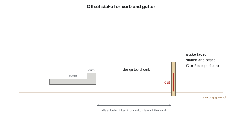
For curb and gutter, stakes are set at regular intervals along tangents, every 25 or 50 ft, and closer on curves, at the beginning and end of each curve and at every catch basin and driveway drop. The cut or fill refers to the top of curb or to the gutter line, as agreed with the contractor at the start of the job. Theo's script computes cuts and fills for four curb stakes on Coulee Ridge Drive from the design profile and the ground elevations Grant's crew measured at each stake, and then computes the angles and distances to set three lot corners by radiation from control point CR-4.
import math
# Offset stakes for the curb on Coulee Ridge Drive and cut/fill to top of curb
offset = 10.0           # stakes set this far behind the back of curb (ft)
stations = [("6+00", 2975.32, 2973.78), ("6+50", 2974.60, 2974.73), ("7+00", 2973.88, 2975.92), ("7+50", 2973.16, 2975.70)]          # station, design top of curb, ground at the stake
for st, design, ground in stations:
    d = design - ground
    print(f"sta {st:>8}  design {design:.2f}  ground {ground:.2f}  {'fill' if d > 0 else 'cut'} {abs(d):.2f} ft")
# Radiation stakeout of lot corners from control point CR-4, backsight to CR-3
cr4 = (5000.00, 3000.00); cr3 = (4377.33, 3042.27)
def az(a, b):
    return math.degrees(math.atan2(b[0] - a[0], b[1] - a[1])) % 360
def dms(x):
    d = int(x); m = int((x - d) * 60); s = (x - d - m / 60) * 3600
    return f"{d:3d}d {m:02d}m {s:04.1f}s"
bs = az(cr4, cr3)
for name, p in [("L1-NE", (5139.80, 3119.27)), ("L1-SE", (5139.80, 3009.27)), ("L2-NE", (5183.80, 3119.27))]:
    a = az(cr4, p)
    turn = (a - bs) % 360
    dist = math.hypot(p[0] - cr4[0], p[1] - cr4[1])
print(f"{name:6} angle right from CR-3 {dms(turn)} distance {dist:8.3f} ft")sta 6+00 design 2975.32 ground 2973.78 fill 1.54 ft sta 6+50 design 2974.60 ground 2974.73 cut 0.13 ft sta 7+00 design 2973.88 ground 2975.92 cut 2.04 ft sta 7+50 design 2973.16 ground 2975.70 cut 2.54 ft L1-NE angle right from CR-3 135d 38m 50.5s distance 183.764 ft L1-SE angle right from CR-3 172d 19m 21.9s distance 140.107 ft L2-NE angle right from CR-3 143d 08m 11.1s distance 219.107 ft
At station 6+00 the ground at the stake is below the design top of curb, so the stake is marked F 1.54; at 7+00 and 7+50 the ground is higher and the stakes are marked C 2.04 and C 2.54. Each stake would also show the offset, for example O/S 10.0, and the station. For the lot corners, the instrument at CR-4 is backsighted on CR-3 and turned to the right through each computed angle; corner L1-NE is set at 183.764 ft and L1-SE at 140.107 ft, and then the distance between the two set points is measured as a check against the plat dimension of 110.00 ft.
Staking curves and bulbs
Curves need more stakes than tangents, and the stakes are computed from the curve data of lesson 5. With a total station, points on the offset curve are usually set by coordinates, computed from the radius plus or minus the offset and the station of each point, and staked by radiation from control. Where a crew prefers the traditional method, it occupies the BC and turns deflection angles to each station, measuring chords along the curve; each deflection is half the central angle subtended from the BC, and each chord is twice the radius times the sine of that deflection. Either way, the EC is checked by measuring to it from the last staked point and comparing with the computed position. Cul-de-sac bulbs are staked at the fillet tangent points, at the points where the bulb meets the fillets and at regular intervals around the bulb, and the curb crew is told which radius each section follows, because a curb machine set to the wrong radius will build a smooth but wrong curve.
Working with the contractor
Staking is a service to the contractor, and its value depends on communication. At the start of each phase, Grant meets the site superintendent to agree on offsets, stake intervals, what each cut or fill refers to, how much notice the contractor will give for each request and how changes to the design will be passed on. Requests come in writing, by text or a shared log, and each completed request is answered with a cut sheet. When a stake is knocked out, the crew resets it from control rather than from neighboring stakes, so that errors do not propagate. Good relations with the contractor's foremen save time on both sides and often catch problems, such as a conflict between a new pipe and an unmapped old one, before they become expensive.
Pipe staking
Sewers and water mains are staked with an offset line along the trench and grade marks at each manhole and at intervals between them. For gravity sewers the critical number is the invert elevation, and the cut from each stake to the invert is given on a cut sheet that the pipe crew uses with a grade rod or, more often now, a pipe laser set in the manhole and aimed along the design slope. The surveyor stakes the manholes, checks the laser setup against the design grade and checks the first lengths of pipe laid, because an error in slope accumulates along the whole run.
Worked problem
Cut to a sewer invert
An offset stake for manhole MH-13 has a top elevation of 2970.40. The design invert of the outgoing pipe is 2958.04. What cut is written on the stake, and what reading should the pipe crew see on a grade rod held on the invert if the instrument line of sight is at 2975.30?
Show solution
- \[\text{cut} = 2970.40 - 2958.04 = 12.36 \text{ ft}\]
- \[\text{rod reading} = 2975.30 - 2958.04 = 17.26 \text{ ft}\]
Answer: The stake is marked C 12.36 to the invert; the rod should read 17.26 ft.
Machine control and 3D models
On many subdivision sites, graders, dozers and excavators now carry GNSS receivers or follow robotic total stations and work directly from a 3D design model loaded in the cab. Machine control removes much of the grade staking for rough grading and subgrade, speeds up the work and reduces rework. It does not remove the surveyor. Someone must build and check the 3D model from the design drawings, set up and check the site calibration and base station, verify the machine's positions against control every day and spot-check the finished surfaces. A model built from the wrong revision of the drawings, or a calibration with a bad control point, will put a whole street at the wrong grade with great efficiency.
At Coulee Ridge, the contractor uses machine control for stripping, rough grading and road subgrade, and conventional stakes for curb, pipes, services and lot corners. Leah builds the model surfaces from the approved design, Ines checks them against the design profiles at every station, and Grant's crew checks the finished subgrade at a grid of points before the granular base is placed. The results go into a short report for Sunil, who must sign off the grades before paving.
Services, lots and houses
Each lot gets a sanitary service, a water service and often a storm service, staked from the main to the property line and marked at the end so that the builder can find it. The service locations and depths are recorded, because a builder who cannot find the end of a service may dig across half a lot looking for it. When the roads and utilities are done, the lot corner monuments are placed and the lots are ready for builders, whose own surveyors will stake each house within the setbacks and later certify its location on a mortgage inspection report or an improvement location certificate, depending on what the lender asks for. Grade certificates from lesson 6 complete the picture.
Safety on the site
Construction sites are dangerous places for survey crews, who work on foot among heavy machines, near open trenches and beside traffic on existing roads. Federal OSHA construction rules and the contractor's site rules apply: high-visibility clothing, hard hats and safety boots, eye contact with operators before moving into a machine's path, staying out of unsupported trenches, and traffic control when working on public roads. Grant's crew attends the contractor's site orientation and daily safety meetings, and they plan their staking so that they are not working in front of machines that are already moving. A crew that stakes ahead of the work, rather than in the middle of it, is both safer and more useful.
Checking and recording
Every stake is checked by an independent measurement before it is released to the contractor: a set point measured from a second control point, a curb run checked by measuring between stakes, a pipe grade checked by level from a different benchmark. As construction proceeds, the crew surveys what was built: manhole rims and inverts, pipe ends, curb lines, valve and hydrant locations. These measurements serve three purposes. They confirm that the work meets tolerances before it is buried, they support the quantities for the contractor's progress payments, and they become the as-built record that the city requires before it accepts the works.
Common mistakes
MistakeSetting stakes on the exact line of the work.
InsteadSet them on an offset line that survives construction, and mark the offset.
MistakeStarting a day of staking without checking control.
InsteadCheck into at least two control points before setting any stake.
MistakeTrusting a machine control model without checking it against the design.
InsteadCheck the model, calibration and finished surfaces independently.
MistakeReleasing stakes without an independent check.
InsteadCheck each set point or grade by a different measurement before the contractor uses it.
Summary and key terms
- Staking follows the construction sequence: clearing, grading, deep utilities, services, roads, walks and lot corners.
- Construction control is densified away from the work and checked before every staking session.
- Offset stakes carry the station, offset and cut or fill to the design grade.
- Pipes are staked with offset lines and invert grades and often laid with a laser.
- Machine control reduces grade stakes but needs checked models, calibrations and spot checks.
- Independent checks and as-built surveys confirm tolerances, support payments and form the record.
- Offset stake
- A stake set at a known distance from the work so that it survives construction.
- Cut and fill
- The vertical distance from a stake reference down to or up to the design grade.
- Cut sheet
- A table of stations, offsets and cuts or fills given to the construction crew.
- Radiation
- Setting points by angle and distance from a single control point.
- Machine control
- Guidance of construction machines from a 3D design model by GNSS or total station.
- As-built survey
- A survey of what was actually constructed, used for acceptance and records.
Practice problems
Work each problem on paper first, then reveal the answer to check.
Why are sanitary sewers usually built first?
Show answer
They are deepest and fixed by gravity, so other utilities fit around them.
What does F 0.30 on a curb stake mean?
Show answer
The design top of curb is 0.30 above the stake reference; fill is needed.
Why measure between two newly set lot corners?
Show answer
To check the set points against the plan dimension independently.
What does the surveyor still do on a machine control job?
Show answer
Build and check the model, set up and verify calibration, and spot-check the surfaces.
Why record the ends of service connections?
Show answer
So builders can find them without digging across the lot.
What three purposes do as-built surveys serve?
Show answer
Tolerance checks before burial, quantities for payment and the record for city acceptance.
Lesson quiz · 5 questions
Score 60% or more to complete this lesson.
Create a free account to save your progress, take quizzes and earn a certificate.