
GEOM-450 · Lesson 12 of 12 · 21 min
Design project
This lesson brings the course together as a design project. The task is the one Ruth's team has worked on all term: take Coulee Ridge from raw land to a design that the city can approve, the developer can finance and the surveyors can build. A design project in land development is never a single correct answer. It is a sequence of choices, each tested against rules, physical constraints and money, and documented so that others can review and approve them. The lesson sets out the brief, compares two concepts, assembles the technical pieces from the earlier lessons, tests the business case and finishes with the professional responsibilities that come with signing the work.
The brief
Dana's brief to Coulee Geomatics and Brightwater is short. Design a residential neighborhood of about 300 homes on the 60.8-acre parcel, with a mix of lot types that suits the local market, a park and a trail along the coulee, and a stormwater system that protects the bank. Meet the city's plans, standards and park requirements. Phase the work so that the first lots can be sold within about two and a half years. Keep the cost per lot within the range that the pro forma can carry, and give the developer a return of at least 15 percent, the board's hurdle rate for projects of this risk.
The brief is turned into a set of measurable criteria before any design is drawn: number of homes, density, share of view lots, length of road per lot, cost per lot, compliance with each standard, walking distance to the park, and the internal rate of return. Criteria agreed at the start make the later comparison of concepts fair and keep the team from moving the goalposts.
Two concepts
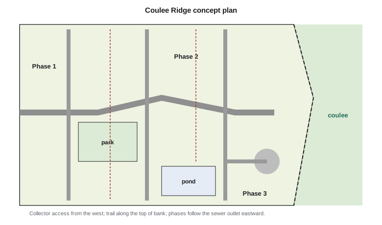
Leah prepares two concepts. Concept A is a modified grid: a collector along the ridge with short local streets across the slope, every block linked to the trail, and no cul-de-sacs. Concept B is curvilinear: a looping collector, longer local streets that follow the contours and three cul-de-sacs reaching toward the coulee for view lots. Both use the same natural area, pond site and servicing outlets from the site analysis, so they differ only in layout.
| Criterion | Weight | Concept A: modified grid | Concept B: curvilinear |
|---|---|---|---|
| Homes | 20 % | 4: about 300 | 5: about 315 |
| View lots | 15 % | 3: 22 lots | 5: 34 lots |
| Road length per lot | 15 % | 4 | 3 |
| Walkability and connectivity | 15 % | 5 | 3 |
| Drainage and servicing fit | 20 % | 4 | 4 |
| Construction cost per lot | 15 % | 4 | 3 |
| Weighted score | 4.00 | 3.90 |
The concepts score almost equally, which is common and useful: it shows that the choice depends on the weights. Concept B gives more view lots, which sell at a premium, but more road per lot and poorer connectivity, which the city's planners dislike. Concept A is cheaper to service and walkable, but loses a dozen view lots. The team recommends a hybrid: Concept A's connected grid for most of the site, with two short cul-de-sacs from Concept B at the coulee edge, each linked by a walkway to the trail. That is the plan the earlier lessons have been working on.
Assembling the technical design
Each earlier lesson contributes a piece of the design, and the capstone checks that the pieces fit. The site analysis fixed the natural area at the geotechnical setback line and put the pond at the low southeast corner. The approvals path set the annexation and zoning as the critical path. The layout gives 254 residential parcels for about 310 homes, with corner lots, cul-de-sac pie lots and laned lots all checked against the district rules. The road geometry fits the collector curve and the cul-de-sac bulbs within the city's standards. The grading plan drains every lot, carries the major flows along the streets and nearly balances the earthwork. The stormwater pond holds the design storm and releases no more than the allowed rate. The sanitary system drains to the west by gravity, and the water system meets fire flow. The phase 1 plat closes, and the construction staking and quantities follow from the same model.
Making the pieces fit is the real work of the capstone. A change in one piece ripples through the others: when the pond moved 30 ft west in lesson 7, three lots changed shape, the walkway moved and the storm sewer outlet lengthened. The geometric design model, built once and edited centrally, is what keeps those ripples under control. So does a single list of open issues, reviewed weekly by the whole team, with each issue assigned to one person and closed only when every affected drawing and report is updated.
The business case
The last check is financial. Theo extends the cost estimate of lesson 11 to all three phases and builds a simple pro forma: land paid at the start, each phase's servicing and municipal charges paid at its start, lots sold at about 45 a year from the year after each phase is built, at a price that grows 2.5 percent a year, less 6 percent for sales costs. The net present value at a 12 percent discount rate and the internal rate of return summarize the result. He then tests two options the team has discussed.
# Pro forma for Coulee Ridge in three phases: net present value and internal rate of return
price = 121_000                 # lot price in year 1
growth = 0.025                  # lot price growth per year
absorb = 45                     # lots sold per year
sell_cost = 0.06                # commissions, legal and marketing
def cashflow(land, phases):
    cash = [0.0] * 14
    for year, amount in land: cash[year] -= amount
    for start, lots, cost in phases:
        cash[start] -= cost
        left, y = lots, start + 1
        while left > 0:
            n = min(absorb, left)
            cash[y] += n * price * (1 + growth) ** (y - 1) * (1 - sell_cost)
            left -= n; y += 1
    while cash[-1] == 0: cash.pop()
    return cash
def npv(cash, r): return sum(c / (1 + r) ** t for t, c in enumerate(cash))
def irr(cash):
    lo, hi = 0.0, 1.0
    for _ in range(60):
        mid = (lo + hi) / 2
        lo, hi = (mid, hi) if npv(cash, mid) > 0 else (lo, mid)
    return lo
base = cashflow([(0, 4_400_000)], [(0, 118, 8_820_000), (3, 86, 6_200_000), (5, 50, 3_700_000)])
for t, c in enumerate(base):
    print(f"year {t:2d} {c:14,.0f}")
cases = {
    "base case": base,
    "land paid in two parts": cashflow([(0, 4_400_000 / 2), (2, 4_400_000 / 2)], [(0, 118, 8_820_000), (3, 86, 6_200_000), (5, 50, 3_700_000)]),
    "phase 3 deferred one year": cashflow([(0, 4_400_000)], [(0, 118, 8_820_000), (3, 86, 6_200_000), (6, 50, 3_700_000)]),
}
for name, cash in cases.items():
print(f"{name:26} NPV at 12% {npv(cash, 0.12):12,.0f} IRR {irr(cash):5.1%}")year 0 -13,220,000 year 1 5,118,300 year 2 5,246,257 year 3 -2,854,054 year 4 5,511,849 year 5 1,447,455 year 6 5,790,887 year 7 659,518 base case NPV at 12% 1,057,116 IRR 14.8% land paid in two parts NPV at 12% 1,503,290 IRR 16.6% phase 3 deferred one year NPV at 12% 1,007,903 IRR 14.7%
The base case is positive at 12 percent, with a net present value of about 1.1 million dollars, but its internal rate of return of 14.8 percent falls just short of the board's 15 percent hurdle. Deferring phase 3 by a year does not help: it delays costs, but it delays sales too. Paying for the land in two installments, half now and half in year 2, lifts the return to about 16.6 percent, comfortably above the hurdle, because the largest single cost is pushed later. Dana takes this to the vendor, who agrees to a two-part payment in exchange for a slightly higher price.
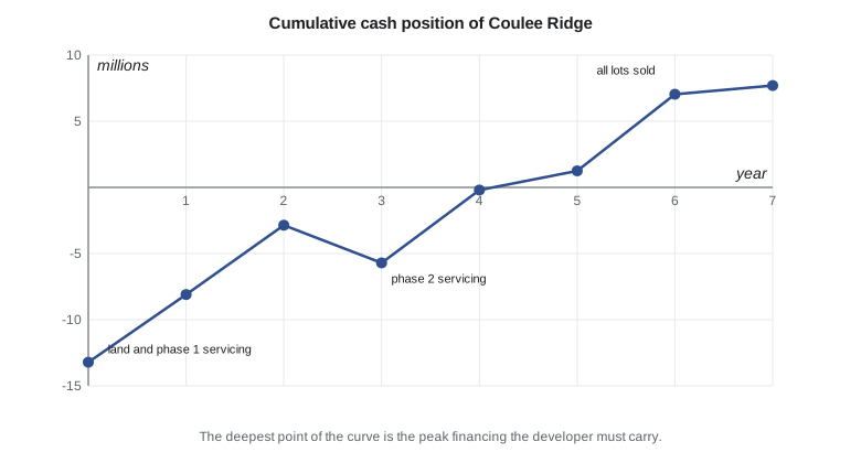
The pro forma also shows the developer's peak financing need, the lowest point of the cumulative cash curve, which is in year 0 before any lots are sold. Lenders look at that number as closely as at the return. The analysis is simple, and real pro formas add monthly timing, financing costs, taxes and sensitivity tests on price and sales pace, but even this version shows the lesson that land developers learn early: timing is worth as much as cost. A design that lets the first lots be sold sooner, or delays large costs until they are needed, can matter more than a cheaper pipe.
Presenting the project
The design is presented several times to different audiences. The annexation and zoning go to public hearings before the city commission, where residents of the neighboring acreages raise concerns about traffic on the gravel road and the view of the coulee. The team's answers are specific: the traffic study's numbers for the new collector connection, a sight-line drawing showing that the trail keeps the coulee edge public, and the geotechnical setback that protects the bank. Clear drawings and plain explanations, prepared from the same model as the engineering, are among the most persuasive tools a design team has.
The subdivision application package then goes to the city: the preliminary plat, the land budget, the site analysis report, the geotechnical and biophysical reports, the servicing and stormwater reports, the traffic study and the phasing plan. Claire's review produces twenty-three comments. Most are small; two need design changes, a wider walkway for a storm sewer and a second emergency access for phase 3, and the team resolves them in a revised submission.
Professional responsibility
Land development affects the public long after the developer has sold the last lot. The surveyors who sign the plat and the engineers who seal the designs owe their first duty to the public, not to the client who pays them. The Montana Board of Professional Engineers and Professional Land Surveyors set codes of conduct that require members to practice only within their competence, to give honest and complete advice, to avoid conflicts of interest and to sign only work they have prepared or supervised and checked. In this project that meant telling the developer that the first concept's lot count was too optimistic, insisting on the geotechnical setback even when it cost lots, and refusing to sign a field survey that did not meet the closure standard. These are the decisions that make a profession worth trusting.
Deliverables of the course project
A course project modeled on Coulee Ridge should produce: a feasibility memo with a yield estimate; an approvals path for the local jurisdiction; a site analysis map set; a dimensioned layout checked against zoning; curve and cul-de-sac computations; a lot grading concept for a typical block; a pond sizing calculation; a servicing concept with a sanitary capacity check; a closed and adjusted boundary with a final plat sketch; a staking plan for one street; a cost estimate for one phase; and a pro forma with at least one option tested. Each deliverable should state its assumptions and the standards it was checked against, as the lessons have done.
What the project teaches
Looking back over the project, the team lists what made the difference. The most valuable early work was the site analysis, because the geotechnical setback and the drainage pattern fixed so much of the layout. The single most important engineering decision was to drain the sanitary system west by gravity, which avoided a lift station and set the phasing. The most useful survey practice was the single design model, from which the layout, grading, quantities, plan dimensions and staking all came. And the most important financial insight was that timing, not just cost, decides whether a subdivision is worth building. These lessons transfer to almost any land development project.
Worked problem
Comparing concepts with different weights
Using the scores in the concept comparison table, recompute the weighted scores if view lots are weighted 25 percent and walkability 5 percent, with the other weights unchanged.
Show solution
- \[A = 0.20(4) + 0.25(3) + 0.15(4) + 0.05(5) + 0.20(4) + 0.15(4) = 3.80\]
- \[B = 0.20(5) + 0.25(5) + 0.15(3) + 0.05(3) + 0.20(4) + 0.15(3) = 4.10\]
Answer: With these weights Concept B scores 4.10 against 3.80: the preferred concept depends on how much the view lots matter relative to walkability, which is why the weights must be agreed and stated.
Common mistakes
MistakeComparing concepts without agreed criteria and weights.
InsteadAgree measurable criteria and weights before drawing the concepts.
MistakeTreating the technical pieces as separate deliverables.
InsteadCheck that grading, servicing, stormwater and layout fit together in one model.
MistakeJudging the project only by its cost per lot.
InsteadInclude timing; returns depend heavily on when costs are paid and lots are sold.
MistakeSigning work under pressure from the client.
InsteadSign only work you have prepared or supervised and checked; the duty is to the public.
Summary and key terms
- A design project turns a brief into measurable criteria before concepts are drawn.
- Concepts are compared with stated weights; robust choices survive reasonable changes in weights.
- The technical pieces, layout, grading, stormwater, servicing, plan and staking, must fit in one design model.
- A pro forma with net present value and internal rate of return tests the business case; timing matters as much as cost.
- Clear presentations and complete applications move a project through public hearings and review.
- Surveyors and engineers owe their first duty to the public and sign only work they can stand behind.
- Design brief
- The client's statement of goals and constraints for a project.
- Concept
- An early layout alternative used to compare approaches.
- Weighted scoring
- Ranking alternatives by scores on criteria multiplied by agreed weights.
- Pro forma
- A projection of a development's costs, revenues and cash flow over time.
- Hurdle rate
- The minimum return a developer requires before committing to a project.
- Peak financing need
- The largest cumulative negative cash position during a project.
Practice problems
Work each problem on paper first, then reveal the answer to check.
Why are criteria agreed before concepts are drawn?
Show answer
So the comparison is fair and the team cannot move the goalposts to favor a preferred design.
Why did deferring phase 3 not improve the return?
Show answer
Sales were deferred along with the costs, so the timing benefit was offset.
Why did paying for the land in two parts help?
Show answer
It moved the largest single cost later, which raises the return on the money invested.
What is the peak financing need, and why do lenders care?
Show answer
The lowest point of the cumulative cash curve; it is the most money the developer must borrow at once.
Name two ways the team answered public concerns at the hearing.
Show answer
Traffic study numbers for the new connection and a sight-line drawing showing the public trail along the coulee.
What did professional responsibility mean in practice on this project?
Show answer
Honest advice on lot yield, insisting on the geotechnical setback and refusing to sign a survey that did not meet the standard.
Lesson quiz · 5 questions
Score 60% or more to complete this lesson.
Create a free account to save your progress, take quizzes and earn a certificate.