
GEOM-450 · Lesson 5 of 12 · 21 min
Road geometry
Streets take a fifth to a quarter of a subdivision's land and a large share of its cost, and once built they last for generations. Their geometry, the alignment in plan, the profile and the cross-section, must be safe for drivers, pedestrians and cyclists, must drain, must carry the utilities and must fit the lots on either side. Detailed highway design belongs to the civil engineer, and an earlier transportation course covers it in depth. This lesson covers what a land development surveyor and designer must know to lay out local and collector streets, compute their curves and fit cul-de-sacs, and it uses Coulee Ridge Drive, the new collector, as its example.
The road hierarchy
Streets in a neighborhood are classified by function. Local streets give access to lots; they carry little traffic at low speed and should not attract through trips. Collectors gather traffic from local streets and lead it to arterials; they carry more traffic, often a bus route, and have fewer driveways. Arterials move traffic between neighborhoods and are usually built by the city rather than the developer, though the developer may pay part of the cost through impact fees. Each class has its own design speed, right-of-way width, pavement width and access rules.
| Street class | Typical right of way | Design speed | Access |
|---|---|---|---|
| Local residential | 50 to 60 ft | 20 to 30 mph | Driveways to every lot |
| Collector | 60 to 80 ft | 30 to 35 mph | Limited driveways |
| Arterial | 100 to 150 ft | 35 to 50 mph | Few or no direct accesses |
In the United States, the AASHTO policy on geometric design of highways and streets, known as the Green Book, is the national reference, adapted by each city in its own standards. The city's standards are what the design is checked against, so Sunil and Leah keep them open on their desks throughout.
The cross-section
The cross-section shows what sits in the right of way: the pavement with its crown, curb and gutter, boulevards, sidewalks or multi-use paths, street trees, street lights and the buried utilities. The pavement is crowned, typically at about 2 percent, so that water runs to the gutters. Curbs channel the water to catch basins; rolled curbs let cars cross anywhere, while barrier curbs need driveway drops. The width of the right of way is set by what must fit in it, and the surveyor must make sure the legal right of way on the plat matches the design cross-section exactly.
Utilities are placed in standard positions in the cross-section so that crews always know where to dig. Lesson 8 shows a typical arrangement. For layout, the important point is that the right-of-way width is not negotiable once the cross-section is set: narrowing it by a meter to fit one more lot can push a utility out of the right of way and into private lots, which creates easements, conflicts and future costs.
Horizontal alignment
The plan of a street is defined by its centerline: straight tangents joined by circular curves, with transition spirals only on faster roads. Each curve is fixed by its radius R and its central angle Δ, which equals the deflection angle between the tangents at their point of intersection, the PI. From these two values come all the other elements: the tangent length T from the beginning of curve, BC, to the PI; the arc length L; the external distance E from the PI to the middle of the curve; the middle ordinate M from the middle of the curve to the long chord; and the long chord LC from BC to the end of curve, EC.
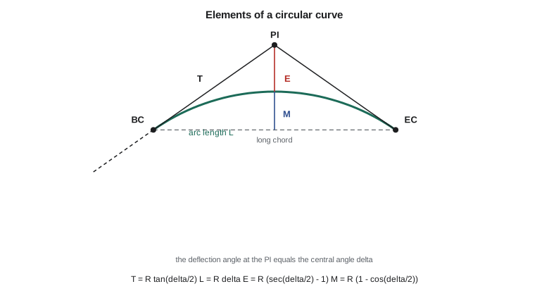
Points along a road are located by stationing, the distance along the centerline from its start. In US practice stations are written as hundreds of feet plus feet, so 8+95.11 is 895.11 ft from the start. The BC station is the PI station minus T, and the EC station is the BC station plus L, not the PI station plus T, because the curve is shorter than the two tangents it replaces.
The minimum radius depends on the design speed, the side friction the tires can safely develop and the cross slope. On a normally crowned urban street, half the pavement slopes the wrong way on a curve, which works against the driver; the minimum radius formula takes this as a negative superelevation of about 2 percent. Theo's script computes the curve on Coulee Ridge Drive, checks its radius against this formula, and then lays out the cul-de-sac bulb at the end of Coulee Court.
import math
# Horizontal curve on Coulee Ridge Drive
R = 400.0                 # radius of the road's axis (ft)
delta = math.radians(38.5)
pi_station = 1034.80       # station of the PI (ft from the start of the road)
T = R * math.tan(delta / 2)
L = R * delta
E = R * (1 / math.cos(delta / 2) - 1)
M = R * (1 - math.cos(delta / 2))
LC = 2 * R * math.sin(delta / 2)
bc = pi_station - T
ec = bc + L
for name, v in (("tangent T", T), ("arc L", L), ("external E", E), ("middle ordinate M", M), ("long chord", LC)):
    print(f"{name:18} {v:8.2f} ft")
print(f"BC at {bc:.2f}, EC at {ec:.2f}")
# Minimum radius check: R = V^2 / (127 (e + f)) in SI, V^2 / (15 (e + f)) in US
V, e, f = 25, -0.02, 0.16           # design speed, normal crown, side friction
Rmin = V ** 2 / (15 * (e + f))
print(f"minimum radius at {V} mph on a normal crown: {Rmin:.0f} ft  ->  {'OK' if R >= Rmin else 'too tight'}")

# Cul-de-sac bulb: street of width w joins a bulb of radius Rb through fillet curves of radius r
w, Rb, r = 60.0, 55.0, 30.0
half = w / 2
# a fillet's middle point: offset half + r from the street axis, distance Rb + r from the bulb middle
y = half + r
x = math.sqrt((Rb + r) ** 2 - y ** 2)
phi = math.asin(y / (Rb + r))              # angle at the middle of the bulb
fillet = r * (math.pi / 2 - phi)           # each fillet arc
bulb = Rb * (2 * math.pi - 2 * phi)         # property line arc around the bulb
print(f"bulb property line arc {bulb:.1f} ft, each fillet {fillet:.1f} ft")
lots = int(bulb // 30.0)
print(f"room for {lots} pie lots with at least {30.0} ft of frontage on the bulb")tangent T 139.69 ft arc L 268.78 ft external E 23.69 ft middle ordinate M 22.36 ft long chord 263.75 ft BC at 895.11, EC at 1163.89 minimum radius at 25 mph on a normal crown: 298 ft -> OK bulb property line arc 259.4 ft, each fillet 23.6 ft room for 8 pie lots with at least 30.0 ft of frontage on the bulb
The curve, with a radius of 400 ft and a central angle of 38.5 degrees, has a tangent of 139.69 ft and an arc of 268.78 ft, so it runs from station 8+95.11 to 11+63.89. At the collector's design speed of 25 mph on a normal crown, the minimum radius is about 298 ft, so the curve is comfortable. Had the city asked for a higher design speed, the radius would have to grow, or the curve would need superelevation, which is unusual on residential streets because of driveways and drainage.
Vertical alignment
The profile of a street is a series of straight grades joined by parabolic vertical curves. The grade must be steep enough for the gutters to drain, usually at least about 0.5 to 0.6 percent, and not so steep that winter driving is unsafe; local streets in prairie cities are often limited to about 6 to 8 percent. Crest curves must be long enough for stopping sight distance, sag curves long enough for headlight distance and comfort, and every sag must have catch basins at its low point. The profile also sets the elevation of every driveway and therefore every lot, which is why lesson 6 on grading and this lesson must be worked together.
At Coulee Ridge the land falls gently from the ridge to the coulee, so local streets running across the slope can follow the ground at about 1 to 3 percent with little earthwork. The collector along the ridge is flatter, and Sunil holds it at a minimum of 0.6 percent by rolling the profile so that it drains to catch basins at regular low points rather than staying flat for hundreds of meters.
Intersections and cul-de-sacs
Intersections should meet as nearly at right angles as possible, and city standards usually require angles of at least about 70 to 75 degrees. Intersections along a collector should be spaced far enough apart that their queues and turning movements do not overlap, and offsets between nearby intersections on opposite sides should be avoided or made large. Each corner gets a curb return radius and a corner cut or sight triangle on the lots, where fences and planting are restricted so drivers can see each other. These corner cuts appear on the plat as part of the right of way.
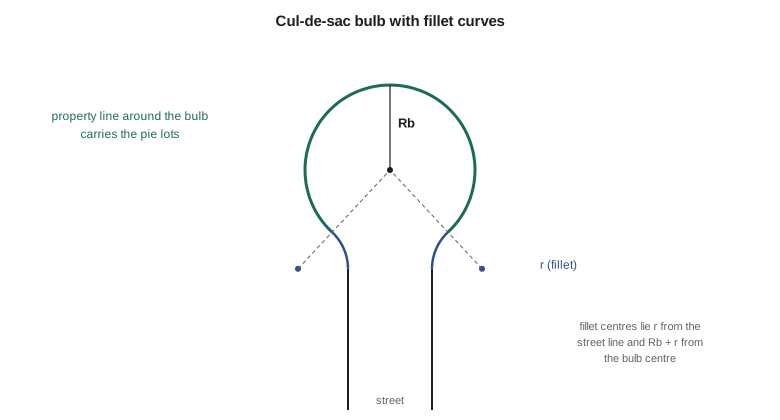
A cul-de-sac ends in a turning bulb large enough for fire trucks, garbage trucks and snow plows to turn around. The fire code, as adopted by the city, sets the minimum turnaround size for dead-end fire access roads, and the city's standards set the maximum cul-de-sac length. The bulb's property line is a circle joined to the street's right-of-way lines by reverse curves, called fillets. The surveyor computes where each fillet meets the street line and the bulb, so that the lot lines and the pie lots can be dimensioned. In Theo's computation, a bulb of radius 55 ft with 30 ft fillets leaves about 259 ft of property line around the bulb, enough for eight pie lots.
Worked problem
Stationing a curve
A curve on a local street has R = 300 ft and Δ = 52°00′00″. The PI is at station 13+75.40. Find T, L and the stations of BC and EC.
Show solution
- \[T = 300\tan 26^\circ = 146.32 \text{ ft}\]
- \[L = 300 \times 52 \times \frac{\pi}{180} = 272.27 \text{ ft}\]
- \[\text{BC} = 1375.40 - 146.32 = 1229.08 \;\to\; 12{+}29.08\]
- \[\text{EC} = 1229.08 + 272.27 = 1501.35 \;\to\; 15{+}01.35\]
Answer: T = 146.32 ft, L = 272.27 ft, BC at 12+29.08 and EC at 15+01.35.
Calming traffic and serving people on foot
Geometry also shapes how people behave on a street. Long straight local streets invite speeding; gentle curves, short blocks, narrower pavements and raised crossings slow traffic without signs. Curb extensions at intersections shorten pedestrian crossings and make the corner radius tighter, which slows turning cars. Many cities now require sidewalks on both sides of collectors and at least one side of local streets, and multi-use paths that connect to schools, parks and transit. These features have geometry of their own, such as path widths, curb ramps, crossing locations and sight lines, and they appear on the plat as rights of way or walkways. Designing them into the first layout is far easier than fitting them in after the lots are fixed.
Coulee Geomatics: fitting roads and lots
Leah's first layout had a tight curve where the collector bends around the park. The curve was fine for traffic, but it left a run of narrow wedge lots on its inside. Flattening it to a 400 ft radius moved the park edge and gave regular lots on both sides. This is a common pattern in subdivision design: road geometry is often chosen as much for the lots it creates as for the traffic it carries, as long as the safety minimums are met.
Common mistakes
MistakeComputing the EC station as the PI station plus T.
InsteadEC equals BC plus the arc length L, because the curve is shorter than the tangents.
MistakeUsing a minimum radius formula with positive superelevation on a crowned urban street.
InsteadOn a normal crown, half the pavement has a negative cross slope; use about −2 percent.
MistakeDesigning a flat street profile to save earthwork.
InsteadKeep a minimum gutter grade, about 0.5 to 0.6 percent, or roll the profile to low points.
MistakeNarrowing the right of way to gain a lot.
InsteadKeep the full cross-section; utilities and sidewalks need the space.
Summary and key terms
- Streets are classified as local, collector and arterial, each with its own speed, width and access rules.
- The cross-section sets the right-of-way width; it must hold pavement, curbs, walks, trees and utilities.
- A circular curve is defined by R and Δ; T, L, E, M and LC follow from them.
- Stations are distances along the centerline; EC equals BC plus L.
- Minimum radii depend on design speed, side friction and cross slope; crowned streets use about −2 percent.
- Profiles need minimum grades for drainage; cul-de-sac bulbs are sized for service and emergency vehicles.
- Right of way
- The strip of land dedicated for a street and its utilities.
- PI
- The point of intersection of two tangents.
- BC and EC
- The beginning and end of a circular curve.
- Station
- A distance along a centerline from its starting point.
- Fillet
- A short curve joining a cul-de-sac bulb or corner to the straight street line.
- Sight triangle
- An area at a corner kept clear so drivers can see approaching traffic.
Practice problems
Work each problem on paper first, then reveal the answer to check.
Which street class should carry through traffic: local or collector?
Show answer
Collector; local streets serve only access to lots.
What is the central angle of a curve in terms of the tangents?
Show answer
It equals the deflection angle between the tangents at the PI.
Why is superelevation rare on residential streets?
Show answer
Driveways, intersections and drainage make tilted pavements impractical at low speeds.
Why must every sag in a street profile have a catch basin?
Show answer
Water collects at the low point and has nowhere else to go.
What is the long chord of a curve with R = 100 and Δ = 60°?
Show answer
2 × 100 × sin 30° = 100, in the same units as R.
Why did Leah flatten the curve around the park?
Show answer
A larger radius gave regular lots instead of narrow wedges on the inside of the curve.
Lesson quiz · 5 questions
Score 60% or more to complete this lesson.
Create a free account to save your progress, take quizzes and earn a certificate.